Introduction
The Timanian Orogeny is an episode of NNE–SSW-oriented contraction that led to the accretion of crustal blocks in the Barents Sea and northwestern Russia onto the northeastern margin of Baltica in the late Neoproterozoic at ca. 650–550 Ma (Olovyanishnikov et al., 2000; Roberts & Olovyanishnikov, 2004; Figure 1a). During this episode, oceanic crust was possibly subducted below Baltica as suggested by blueschist metamorphism and potential island-arc magmatism (Beckholmen & Glodny, 2004; Dovzhikova et al., 2004; Gee et al., 2000; Kostyuchenko et al., 2006; Olovyanishnikov et al., 2000; Pease et al., 2004; Remizov, 2006; Remizov & Pease, 2004). Onshore northern Norway and northwestern Russia, the Timanian Orogen is characterized by NNE-dipping thrust systems (Lorenz et al., 2004; Olovyanishnikov et al., 2000; Roberts et al., 2004; Siedlecka, 1975; Siedlecka & Roberts, 1995; Siedlecka & Siedlecki, 1967; Siedlecka & Siedlecki, 1971; Figure 1a).
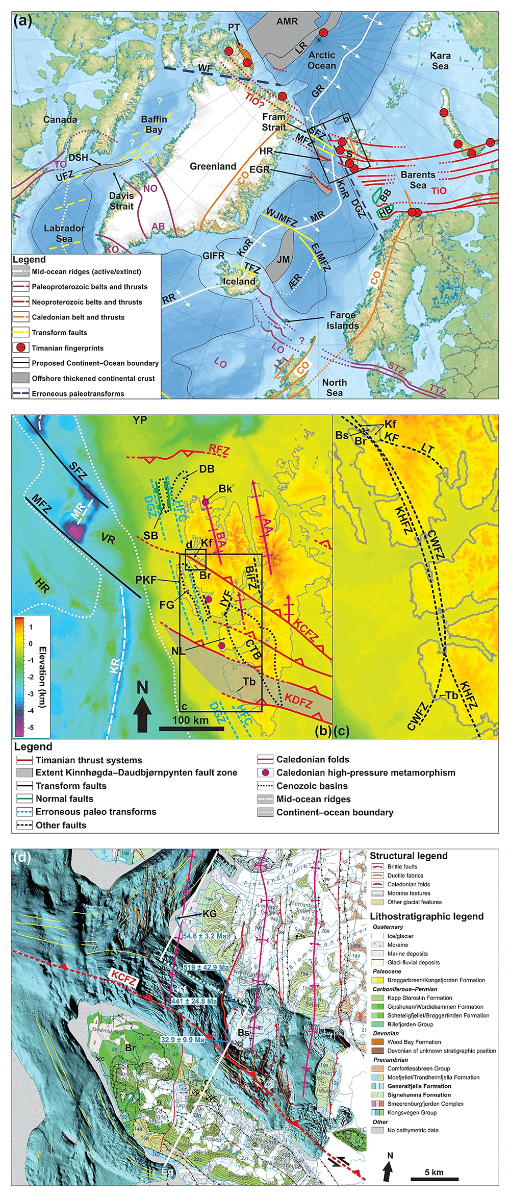
Figure 1. Overview maps of the study area.
(a) Overview map of the northeastern Atlantic and Arctic oceans. Basemap is from Jakobsson et al. (2012). Modified after Koehl & Foulger (2025 awaiting peer review). Abbreviations: AB: Ammassalik Belt; AMR: Alpha–Mendeleev Ridge; BB: Bjørnøya Basin; CO: Caledonian Orogen; DGZ: De Geer Zone; EGR: DSH Davis Strait High; East Greenland Ridge; EJMFZ: East Jan Mayen fault zone; GIFR: Greenland–Iceland–Faroe Ridge; GR: Gakkel Ridge; HB: Hammerfest Basin; HR: Hovgård Ridge; JM: Jan Mayen Microcontinent Complex; KnR: KO: Ketilidian Orogen; Knipovich Ridge; KoR: Kolbeinsey Ridge; LO: Laxfordian Orogen; LR: Lomonosov Ridge; MFZ: Molloy fault zone; MR: Mohns Ridge; NO: Nagssugtoqidian Orogen; PT: Pearya Terrane; RR: Reykjanes Ridge; S: Svalbard; SFZ: Spitsbergen fault zone; STZ: Sorgenfrei–Tornquist Zone; TFZ: Tjörnes fault zone; TiO: Timanian Orogen; TO: Torngat Orogen; TTZ: Teisseyre–Tornquist Zone; UFZ: Ungava Fault Zone; WF: Wegener Fault; WJMFZ: West Jan Mayen fault zone; ÆR: Ægir Ridge. (b) Overview of major structures in Spitsbergen. Basemap is from Jakobsson et al. (2012). Location is shown in (a). Abbreviations: AA: Atomfjella Antiform; BA: Bockfjorden Anticline; Bi: Billefjorden; BiFZ: Billefjorden Fault Zone; Bk: Biskayarhalvøya; Br: Brøggerhalvøya; CTB: Central Tertiary Basin; DB: Danskøya Basin; DGZ: De Geer Zone; FG: Forlandsundet Graben; HFC: Hornsund Fault Complex; HR: Hovgård Ridge; IYF: Isfjorden–Ymerbukta Fault; KCFZ: Kongsfjorden–Cowanodden fault zone; KDFZ: Kinnhøgda–Daudbjørnpynten fault zone; Kf: Kongsfjorden; KR: Knipovich Ridge; MFZ: Molloy fault zone; MR: Molloy Ridge; NL: Nordenskiöld Land; PKF: Prins Karls Forland; RFZ: Risen fault zone; Sa: Sassenfjorden; SB: Sjubrebanken basin; SFZ: Spitsbergen fault zone; Tb: Torellbreen; VR: Vestnesa Ridge; YP: Yermak Plateau. (c) Zoom in (b) showing previously speculated faults in the Kongsfjorden area. Fault outlines are from Harland & Horsfield (1974), Harland & Wright (1979), and Harland et al. (1993). Location is shown in (b). Abbreviations: Br: Brøggerhalvøya; Bs: Blomstrandøya; CWFZ: Central–West Fault Zone; Kf: Kongsfjorden; KF: Kongsvegen Fault; KHFZ: Kongsfjorden–Hansbreen Fault Zone; LT: Lappdalen Thrust; Tb: Torellbreen. (d) Geological map of the study area in Kongsfjorden. Interpreted geological features in nearshore bathymetric data are from ongoing work and are not discussed in the present manuscript. The thick white lines show the location of the transect displayed in Figure 15. The geological units are from Dallmann (2015) and the bathymetric data from the Norwegian Mapping Authority and Norwegian Polar Institute. Location is shown in (b). Abbreviations: Br: Brøggerhalvøya; Bs: Blomstrandøya; Eg: Engelskbukta; KCFZ: Kongsfjorden–Cowanodden fault zone; Kf: Kongsfjorden; KP: Kapp Guissez.
Late Neoproterozoic contraction and metamorphism have been previously documented in Svalbard (Birkenmajer, 1991; Bjørnerud, 1990; Bjørnerud et al., 1991; Dallmeyer et al., 1990a; Faehnrich et al., 2020; Griffin et al., 2012; Koglin et al., 2022; Majka et al., 2008; Majka et al., 2012; Manecki et al., 1998; Peucat et al., 1989), and more recently from the conjugate rifted margin in northern Greenland and Arctic Canada (Estrada et al., 2018a; Estrada et al., 2018b; Rosa et al., 2016; Figure 1a). However, their relationship to the Timanian Orogen in northern Norway and northwestern Russia is uncertain.
The rock units which record late Neoproterozoic (Torellian) tectonism in Svalbard show affinities with the Pearya Terrane in Arctic Canada (e.g., Majka et al., 2021; Piepjohn et al., 2016; Figure 1a). These rock units and late Neoproterozoic Torellian tectonism were interpreted as exotic to Svalbard and current models for the amalgamation of these crustal blocks involve tens to hundred km strike-slip displacement (e.g., Majka et al., 2021).
However, recent structural interpretation of regional geophysical datasets indicates that structures of the late Neoproterozoic Timanian Orogen extend across the Barents Sea from northwestern Russia to southern and central Svalbard (Koehl, 2020; Koehl et al., 2022a; Figure 1a–b). This thus suggests that the episode of late Neoproterozoic (Torellian) tectonism in Svalbard may correspond to the western continuation of the Timanian Orogen.
The present study aims to test whether an anomalous WNW–ESE-striking fault zone in central western Spitsbergen could represent the western extension of a late Neoproterozoic Timanian thrust system, the Kongsfjorden–Cowanodden fault zone, which was mapped on seismic reflection data in the Barents Sea and central Spitsbergen (Sassenfjorden–Billefjorden; Koehl, 2020; Koehl et al., 2022a; Figure 1a–b).
The targeted fault in Kongsfjorden, western Spitsbergen, has been suspected for some time, but its location, geometry, and tectonic evolution remain poorly understood. It was initially interpreted in Oscar II Land as a Carboniferous–Cenozoic fault with top-NNE kinematics (Kongsvegen fault), which presumably continued to the southeast as a mid–late Cenozoic top-NNE thrust (Lappdalen thrust; Harland & Horsfield, 1974; Figure 1c). Later studies speculated it to be a Late Devonian sinistral fault and suggested that it bent into a N–S strike in Isfjorden and into a NE–SW strike in Torellbreen (Kongsvegen fault zone and Central–West fault zone of Harland & Wright, 1979; Figure 1c). Subsequently, the fault was reinterpreted with a N–S strike south of Torellbreen and renamed the Kongsfjorden–Hansbreen fault zone (Harland et al., 1993). The latter was thought to have been offset or reworked by NNE–SSW-striking faults during the Cenozoic, e.g., the Isfjorden–Ymerbukta Fault (e.g., Bergh et al., 1997; Braathen et al., 1999; Harland & Horsfield, 1974; Harland et al., 1993; Figure 1b).
A secondary goal included constraining the impact of early Cenozoic Eurekan contractional and late Cenozoic extensional reactivation–overprinting on preexisting structures, especially that of margin-oblique WNW–ESE-striking faults (Koehl et al., 2022a).
The structural and geochronological data presented provide a more definitive answer on the formation, geometry, and tectonic evolution of the anomalous WNW–ESE-striking fault in Kongsfjorden and allow correlation with nearby regional structures.
The present work has implications for structural inheritance during rifting, transform faulting, and plate tectonics in general, especially with regards to Orogenic Bridge Theory. The present results further showcase the use of U–Pb geochronology in resolving Precambrian–Paleozoic plate tectonics using syn-kinematic carbonate veins and marble. It also impacts on how geoscientists should approach outcrops when attempting to find traces of old tectonic episodes and sampling for geochronological analysis.
Geological setting
Timanian Orogeny
Precambrian basement rocks in the Svalbard Archipelago include metasedimentary and metaigneous rocks of generally poorly constrained age, especially in western Spitsbergen (e.g., Dallmann, 2015; Hjelle et al., 1999). These rocks are believed to belong to a series of terranes with varying affinities presumably amalgamated during the early–mid Paleozoic Caledonian Orogeny. For example, basement rocks in southwestern Svalbard show affinities to Baltica and the Pearya Terrane in Arctic Canada (e.g., Majka et al., 2015; Mazur et al., 2009), whereas basement rocks in northeastern Svalbard show affinities to northern Greenland (e.g., Harland et al., 1993). Some of these rocks show traces of a NNE–SSW-oriented episode of late Neoproterozoic contraction, the Timanian Orogeny, including WNW–ESE-striking shear zones, amphibolite- and eclogite-facies metamorphism, magmatism, and major unconformities in southwestern and northwestern Svalbard (Birkenmajer, 1991; Bjørnerud, 1990; Bjørnerud et al., 1991; Dallmeyer et al., 1990a; Faehnrich et al., 2020; Griffin et al., 2012; Koglin et al., 2022; Manecki et al., 1998; Majka et al., 2008; Majka et al., 2012; Mazur et al., 2009; Peucat et al., 1989; Figure 1a).
The Timanian Orogeny is constrained to ca. 650–550 Ma in northwestern Russia and northern Norway, where it is characterized by dominantly top-SSW, crustal-scale thrust systems and related blueschist- and eclogite-facies metamorphism and magmatism (e.g., Dallmeyer & Reuter, 1989; Dovzhikova et al., 2004; Gee et al., 2000; Glodny et al., 2004; Gorokhov et al., 2001; Korago et al., 2004; Kostyuchenko et al., 2006; Kuznetsov et al., 2007; Larionov et al., 2004; Lopatin et al., 2001; Lorenz et al., 2004; Olovyanishnikov et al., 2000; Pease et al., 2004; Remizov, 2006; Remizov & Pease, 2004; Siedlecka, 1975; Siedlecka & Roberts, 1995; Figure 1a). In Russia, age constrains for the Timanian Orogeny include ca. 555–544 Ma U–Pb zircon and ca. 618–550 Pb–Pb evaporation zircon ages for (late) syn-kinematic (to post-kinematic?), island-arc, suprasubduction granodioritic intrusions in the Pechora Basin (Andreichev et al., 2017; Gee et al., 2000; Pease et al., 2004), ca. 640–594 Ma Pb–Pb evaporation and U–Pb zircon ages for magmatic rocks in the Timan Range (Larionov et al., 2004), ca. 578 Ma U–Pb zircon and ca. 537–536 Ma Rb–Sr ages for blueschist metamorphism in the northern Urals (Beckholmen & Glodny, 2004; Remizov, 2006; Remizov & Pease, 2004), ca. 533–532 Ma U–Pb zircon and Rb–Sr ages for eclogite metamorphism in the southern Urals (Valizer et al., 2015; Willner et al., 2019), and a ca. 585 Ma U–Pb zircon age for ophiolites in the northern Urals (Savelieva et al., 2007). In northern Norway, age constraints include ca. 650 Ma and ca. 560–530 Ma Rb–Sr clay ages and ca. 650–635 Ma and ca. 575–550 Ma whole-rock 40Ar–39Ar ages suggesting late Neoproterozoic diagenesis (Dallmeyer & Reuter, 1989; Gorokhov et al., 2001), and potentially ca. 580–560 Ma and ca. 530–520 Ma U–Pb zircon ages for the Seiland Igneous Province (Roberts et al., 2006; Roberts et al., 2010), which has recently been suggested to have formed in a backarc setting (Koehl & Stokmo, 2024). Traces of late Neoproterozoic orogenesis probably related to the Timanian Orogeny are also recorded in northern Greenland (Estrada et al., 2018a; Rosa et al., 2016), Arctic Canada (Estrada et al., 2018b), the Lomonosov Ridge (Rekant et al., 2019), Taimyr and Siberia (Kröner et al., 2015; Kuzmichev et al., 2008; Pease & Scott, 2009; Pease & Vernikovsky, 2000; Priyatkina et al., 2017; Vernikovsky et al., 2004; Vernikovskaya et al., 2020), the De Long Islands (Akinin et al., 2015; Ershova et al., 2016), and Wrangel Island and Chukotka (Gottlieb et al., 2018; Natal’in et al., 1999).
Recent structural mapping on geophysical data in the Barents Sea suggests that WNW–ESE-striking Timanian thrust systems extend continuously across the Barents Sea and Svalbard (Klitzke et al., 2019; Koehl, 2020; Koehl, 2025; Koehl & Stokmo, 2024; Koehl et al., 2022a; Koehl et al., 2023a; Koehl et al., 2023b; Figure 1a). These studies suggest that Svalbard’s basement rocks were already all amalgamated and attached to Baltica in the late Neoproterozoic.
Caledonian Orogeny
In the Middle Ordovician–Silurian (ca. 465–425 Ma), Svalbard was involved in E–W-oriented Caledonian contraction, which is characterized by N–S-striking folds, thrusts, and foliation and blueschist- and eclogite-facies metamorphism (Birkenmajer, 1975; Birkenmajer, 2004; Dallmeyer et al., 1990b; Dumais & Brönner, 2020; Faehnrich et al., 2020; Gee & Hjelle, 1966; Gee & Page, 1994; Gee et al., 1992; Hjelle, 1979; Horsfield, 1972; Johansson et al., 2004; Johansson et al., 2005; Koglin et al., 2022; Manby, 1986; Ohta et al., 1989; Ohta et al., 1995; Witt-Nilsson et al., 1998; Figure 1a–b). In the study area (Kongsfjorden; Figure 1b–d), N–S-striking structures are widespread in Precambrian (tentatively Mesoproterozoic–earliest Neoproterozoic?) marbles and subsidiary phyllitic schist of the Generalfjella Formation and phyllitic to psammitic (garnet) micaschists with layers quartzite of the Signehamna Formation, which are gently folded and truncated by a pervasive foliation (Gee & Hjelle, 1966; Hjelle, 1979; Hjelle et al., 1999; Siggerud, 1963). Time equivalent units in Brøggerhalvøya are rocks of the Kongsvegen Group, which consist of similar rock types, i.e., phyllite, marble, and garnet micaschist with interlayered quartzite. Despite these similarities, regional correlations across Kongsfjorden are uncertain (e.g., Dallmann, 2015).
Late–post Caledonian collapse
Late–post-Caledonian extensional collapse is thought to have initiated in the latest Silurian with low-angle detachment faulting, some of which bounding potential core complexes (e.g., Braathen et al., 2018; Chorowicz, 1992; Koehl et al., 2022a; Koehl et al., 2023b; Roy, 2007). This is suggested by a ca. 429 Ma 40Ar–39Ar biotite age in mylonitic fault rock in northern Spitsbergen (Braathen et al., 2018). Extensional faulting was accompanied with the deposition of up to 9–10 km thick sedimentary rocks (e.g., Friend & Moody-Stuart, 1972; Friend et al., 1966; Murascov & Mokin, 1979). Extension continued in the Mississippian before fading away in the Early–Middle Pennsylvanian (Aakvik, 1981; Gjelberg, 1984; Koehl & Muñoz-Barrera, 2018; Koehl et al., 2023c; McCann & Dallmann, 1996).
In the study area in Blomstrandøya, reddish Devonian conglomerates (Gjelsvik, 1974) were tentatively correlated to the Liljeborgfjellet and Wulffberget formations (Dallmannn & Piepjohn, 2020; Murascov & Mokin, 1979). The conglomerates on Blomstrandøya are seemingly thrust onto basement marbles of the Generalfjella Formation (Thiedig & Manby, 1992). It has been tentatively suggested that some of these structures formed during an episode Late Devonian E–W-oriented contraction, the Svalbardian Orogeny (Dallmann & Piepjohn, 2020; Kempe et al., 1997; Piepjohn, 2000). However, recent paleontological and structural studies suggest that this is unlikely (Koehl et al., 2022b and references therein).
Eurekan tectonic episode
In the early Cenozoic, Svalbard experienced E–W-oriented Eurekan contraction, which resulted in the formation of dominantly N–S-striking folds and thrusts of the West Spitsbergen Fold-and-Thrust Belt in western Spitsbergen and in the deposition of sedimentary basins such as the Central Tertiary Basin (Bergh et al., 1997; Dallmann et al., 1993; Maher et al., 1986; Steel et al., 1981; Tessensohn, 2001). In Brøggerhalvøya, the fold-and-thrust belt bends into a WNW–ESE strike and Precambrian basement rocks were thrust onto Carboniferous–Permian and lower Cenozoic sedimentary rocks (Bergh et al., 2000; Piepjohn et al., 2001; Saalmann & Brommer, 1997; Saalmann & Thiedig, 2000; Saalmann & Thiedig, 2001; Saalmann et al., 1997). This event is constrained by 40Ar–39Ar, K–Ar, U–Pb, and U–(Th)–Pb geochronology to ca. 67–44 Ma (Barnes & Schneider, 2018; Blythe & Kleinspehn, 1998; Charles et al., 2011; Haaland et al., 2024; Jones et al., 2017; Schaaf et al., 2020; Schneider et al., 2018; Tessensohn et al., 2001).
Notably, Eurekan tectonism in Svalbard is constrained by ca. 67–50 Ma K–Ar ages for syn-kinematic clays in slates (Tessensohn et al., 2001), a ca. 53.5 Ma K–Ar age for syn-kinematic clay in fault gouge (Schaaf et al., 2020), ca. 55–44 Ma 40Ar–39Ar ages for muscovites (Schneider et al., 2018), ca. 53–47 Ma (U–Th)/He ages for detrital zircons (Barnes & Schneider, 2018), and a ca. 59 Ma U–Pb age for syn-kinematic carbonates (Haaland et al., 2024). Deposition of related foreland basins such as the Central Tertiary Basin is constrained by ca. 64–63 Ma ages from fission track data for detrital apatite (Blythe & Kleinspehn, 1998), and ca. 52–44 Ma K–Ar ages (Tessensohn et al., 2001) and ca. 61.5–55.8 Ma U–Pb ages for bentonites in the Central Tertiary Basin (Charles et al., 2011; Jones et al., 2017).
This overlaps with the initiation of the Mohns Ridge between in the northeastern Atlantic and Gakkel Ridge in the Arctic Ocean at ca. 56 Ma (Faleide et al., 1993; Faleide et al., 2008; Gaina et al., 2002; Srivastana, 1985; Figure 1a). Coeval rifting in the northeastern Atlantic and Arctic oceans and contractional structures in Svalbard were previously reconciled with an overall transpressional tectonic regime for the West Spitsbergen Fold-and-Thrust Belt (e.g., Bergh & Grogan, 2003; Bergh et al., 2000; Leever et al., 2011). In this scenario, the De Geer Zone, a postulated major paleo-transform fault off western Svalbard and the western Barents Sea (Figure 1a), is believed to have accommodated c. 400 km of dextral movement (De Geer, 1926; du Toit, 1937; Faleide et al., 1993; Faleide et al., 2008; Harland, 1961; Harland, 1967; Harland, 1969; Holtedahl, 1936; Horsfield & Maton, 1970; Piepjohn et al., 2016; Wegmann, 1948). However, the existence of such a fault was recently invalidated by seismic mapping of late Neoproterozoic Timanian thrust systems across the presumed trace of this fault (Koehl, 2025).
Late Cenozoic opening of the Fram Strait
In the mid Cenozoic, the tectonic regime in western Svalbard is believed to have changed to transtension. This is supported, e.g., by (U–Th)/He detrital zircon thermochronology, which suggest a period of exhumation at ca. 47–34 Ma (Barnes & Schneider, 2018), and by U–Pb geochronology of syn-kinematic carbonates suggesting normal faulting at ca. 41–33 Ma and ca. 13 Ma (Haaland et al., 2024). Transtension resulted in a c. 90° bend of the rift system into a NNW–SSE strike (instead of ENE–WSW) along the western Svalbard–Barents Sea margin and opening of the Fram Strait at ca. 24 Ma (Engen et al., 2008), i.e., significantly later than breakup in the northeastern Atlantic and Arctic oceanic domains (at ca. 56 Ma).
Recent seismic mapping has shown that N–S-striking faults, e.g., Hornsund Fault Complex, accommodated dominantly normal movements during the mid–late Cenozoic (Koehl, 2025). Thus, most transform faulting between Svalbard and Greenland was likely accommodated by the currently active transform faults in the Fram Strait, the Molloy and Spitsbergen fault zones (Koehl, 2025; Figure 1a). This is supported by transtensional folding along a NW–SE-striking axis in the Forlandsundet Graben (Schaaf et al., 2020).
Methods
Structural fieldwork
Structural fieldwork and U–Pb geochronological analysis of syn-tectonic carbonates in deformed veins were used to characterize brittle–ductile deformation structures in Kongsfjorden. Measurements of foliation, bedding, and fracture surfaces and fold axes were collected with geological compasses and observations of structure geometries and kinematic indicators were collected both in outcrop and at microscopic scale, to correlate with regional structural strikes and the dated tectonic episodes (Figure 2–Figure 12a–b; Koehl & Stokmo, 2022a; Koehl & Stokmo, 2022b).
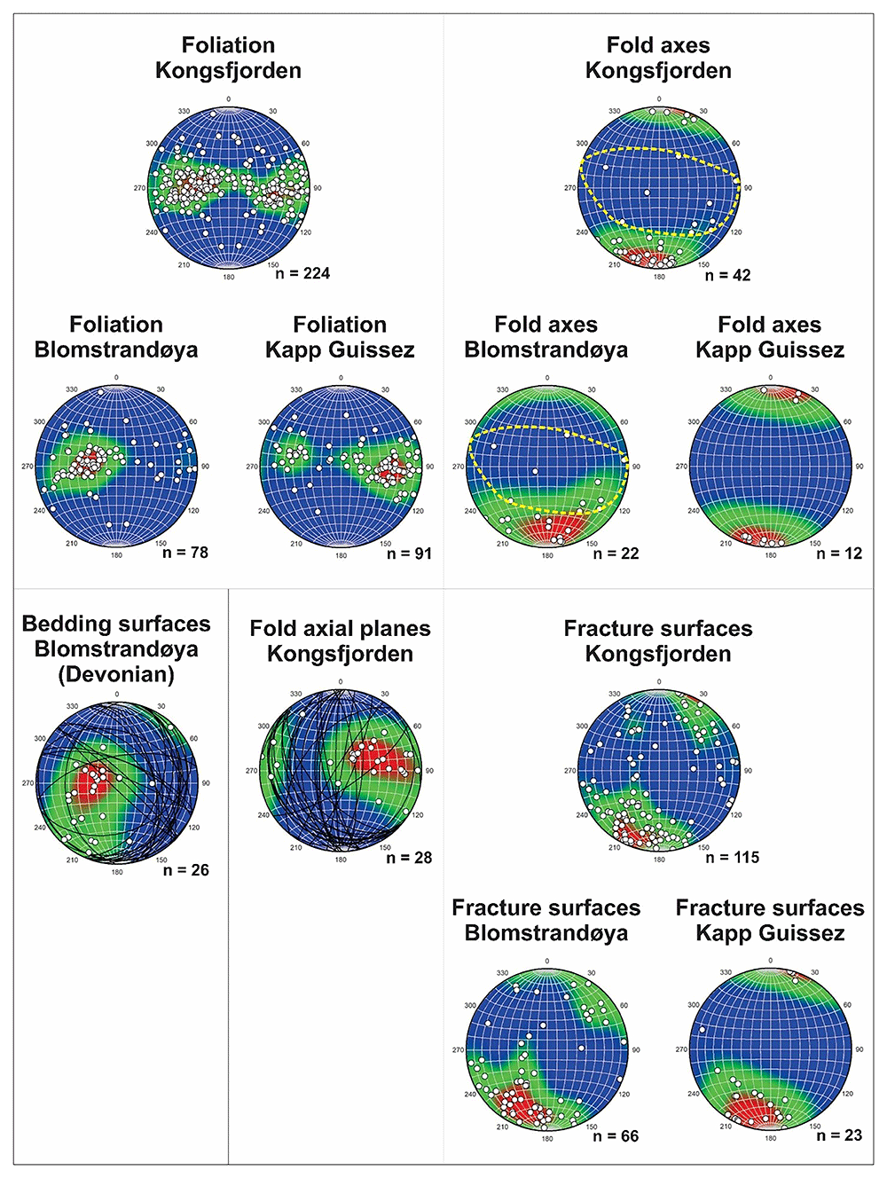
Figure 2. Structural measurements in Kongsfjorden.
Stereonets display gradient shading with red-colored high density and blue-colored low density. The data are displayed as poles to plane. Great circles were added to the stereonets showing axial fold planes and bedding surfaces in Devonian sedimentary rocks to further illustrate the WNW–ESE-striking Timanian and N–S-striking Caledonian fold trends. The Timanian fold trend is also highlighted by dashed yellow lines in the stereonets showing fold axes in Blomstrandøya and whole study area (Kongsfjorden). Notice the variation from gently east-dipping to dominantly west-dipping of the Caledonian foliation in Blomstrandøya and Kapp Guissez, which indicates positions on opposite N–S-striking Caledonian fold limbs (Figure 1d).
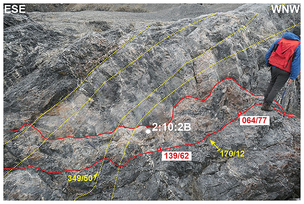
Figure 3. Outcrop photograph of the E–W-striking fault zone in northwestern Blomstrandøya.
The fault zone crosscuts marbles of the Generalfjella Formation and consists of µm- to mm-scale carbonate veins and iron-rich cataclastic fault rock. The fault is folded along a N–S-striking axis (i.e., showing alternating WNW–ESE- and ENE–ESE-striking segments) and truncated by the Caledonian foliation. The photo shows the location of sample 2:10:2B, in which gently folded carbonate veins yielded a 519 ± 42.9 Ma U–Pb age. Legend is in Figure 5.
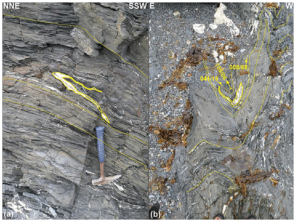
Figure 4. Outcrop photograph of isoclinally folded carbonate veins in northern Blomstrandøya.
Outcrop photographs showing carbonate veins isoclinally folded in 3D and their relationship to the N–S-striking Caledonian foliation. (a) NNE–SSW-oriented outcrop transect showing that, unlike the Caledonian foliation by which they are truncated, carbonate veins are folded along a WNW–ESE-striking axis. This suggests an episode of pre-Caledonian, NNE–SSW-oriented contraction. (b) N–S-oriented outcrop transect showing Caledonian N–S-striking folding of the carbonate veins folded together with the foliation. Legend is in Figure 5.
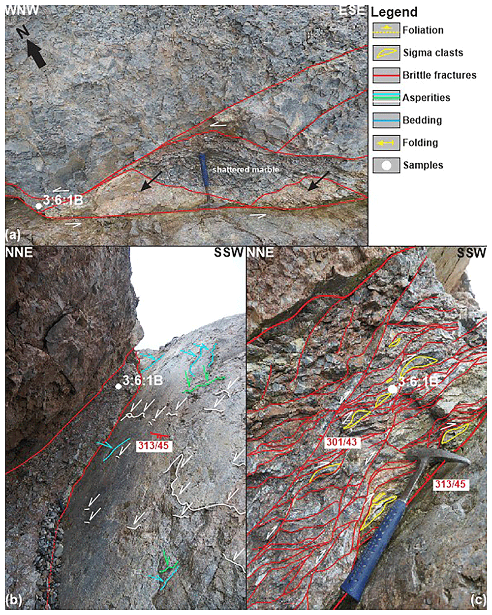
Figure 5. Outcrop photographs of the NNE-dipping fault zone in southwestern Blomstrandøya.
(a) In map view, the fault zone consists of lenses of shattered marble and calcite-cemented cataclastic fault rocks (black arrows). (b) Major fault surfaces show asperities indicating sinistral strike-slip (light blue), normal dip-slip (white), and composite sinistral-normal oblique-slip (green) movement. (c) The fault shows S–C-like brittle fabrics suggesting top-SSW thrusting and/or down-NNE normal movements, and sigma clasts indicating top-SSW thrusting. (a–c) show the location of sample 3:6:1B in which carbonate veins and marble bedrock yielded respectively 54.6 ± 3.2 Ma and 441 ± 24.8 Ma U–Pb ages.
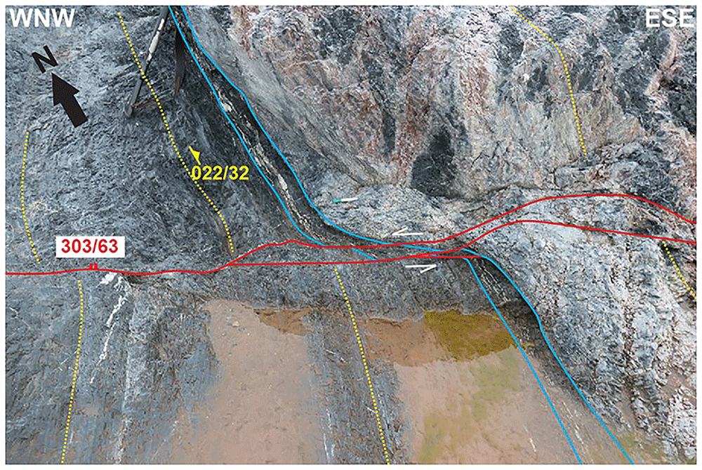
Figure 6. Outcrop photograph of sinistral strike-slip offset in southwestern Blomstrandøya.
NNE-dipping fault consisting of carbonate veins and cataclastic fault rock offsetting bedding and the N–S-striking Caledonian foliation. This suggests post-Caledonian sinistral strike-slip reactivation of WNW–ESE-striking faults in Blomstrandøya. Legend is in Figure 5.
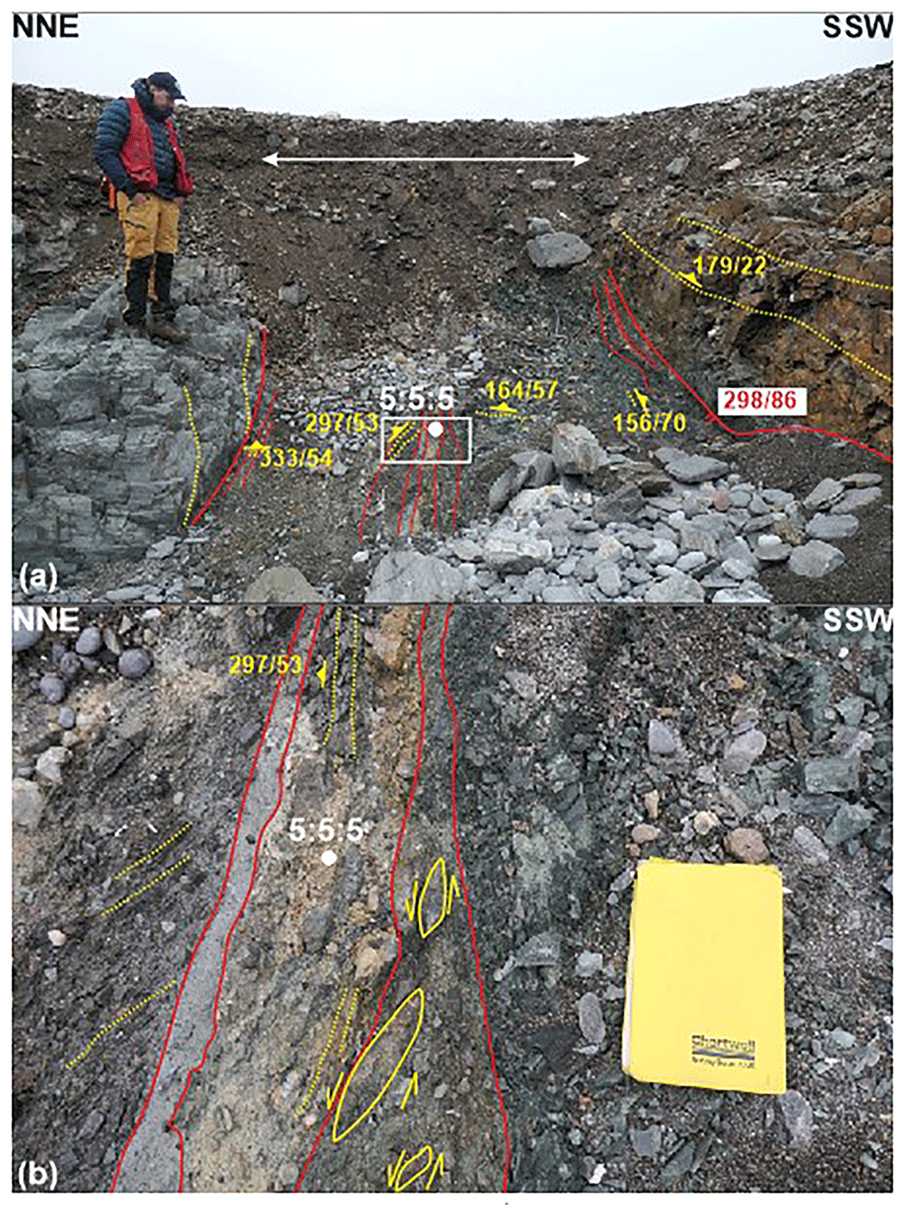
Figure 7. Outcrop photograph of the subvertical WNW–ESE-striking fault at Kapp Guissez.
(a) The three-meter-wide fault zone truncates the gently east-dipping Caledonian foliation. Clasts of micaschist bedrock with foliation bending into a WNW–ESE strike are found within the fault zone. (b) The fault rock includes cm- to tens-of-cm-thick layers of greyish clay-rich fault gouge and clasts of marbles, as well as sigma clasts indicating sinistral strike-slip post-Caledonian movements (b). Legend is in Figure 5.
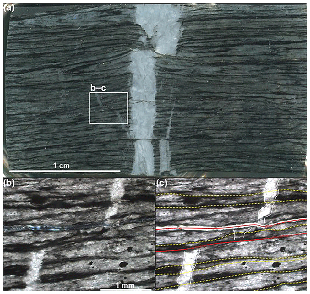
Figure 8. Isoclinally folded carbonate veins in northwestern Blomstrandøya.
(a) Polished sample showing µm- to hundred-µm-scale, isoclinally folded carbonate veins truncated by the Caledonian foliation. (b) Uninterpreted polarized-light and (c) interpreted non-polarized-light microscope photograph of an isoclinally folded carbonate vein (white lines) truncated by the Caledonian foliation (dotted yellow lines) and by post-Caledonian cracks (red lines). Location of (b–c) is shown in (a).
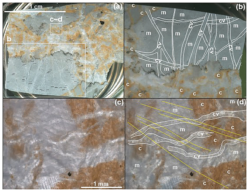
Figure 9. Gently folded carbonate veins in northwestern Blomstrandøya.
(a) Overview of the dated sample 2:10:2B thick section showing the iron-rich, partly carbonate-cemented cataclasite truncating clasts of marble crosscut by hundred-µm- to mm-scale carbonate veins. (b) is a zoom into the lower left corner of (a) and shows the dated gently folded carbonate veins, which yielded the 519 ± 42.9 Ma U–Pb age. Location shown in (a). (c) Uninterpreted non-polarized-light and (b) interpreted polarized-light microscope photograph showing that the gently folded carbonate veins are truncated by the Caledonian foliation (dotted yellow lines). Location of (c–d) is shown in (a). Abbreviations: c: cataclasite; cv: carbonate vein; m: marble.
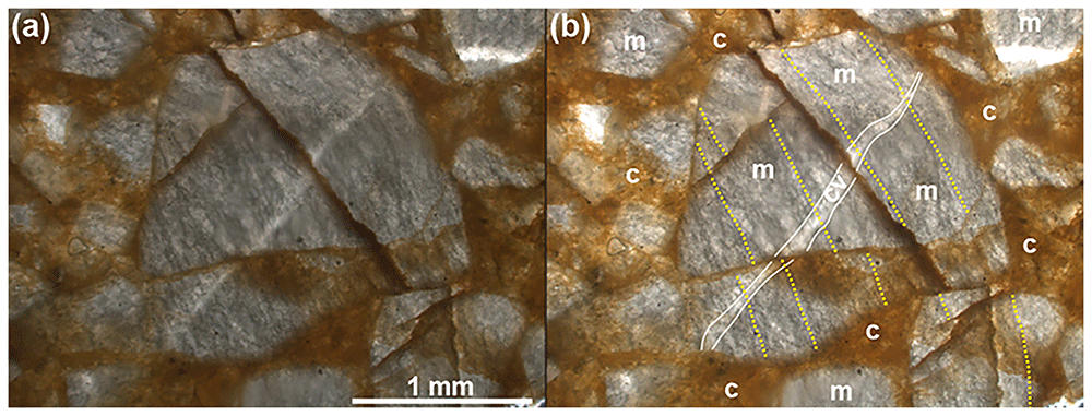
Figure 10. Gently folded carbonate veins truncated by foliation and cataclasite.
(a) Uninterpreted polarized-light and (b) interpreted non-polarized-light microscope photograph of iron- and clay-rich cataclastic fault rock comprising clasts of foliated marble truncated by foliated carbonate veins. This suggests an episode of pre-Caledonian tectonism. Abbreviations: c: cataclasite; cv: carbonate vein; m: marble.
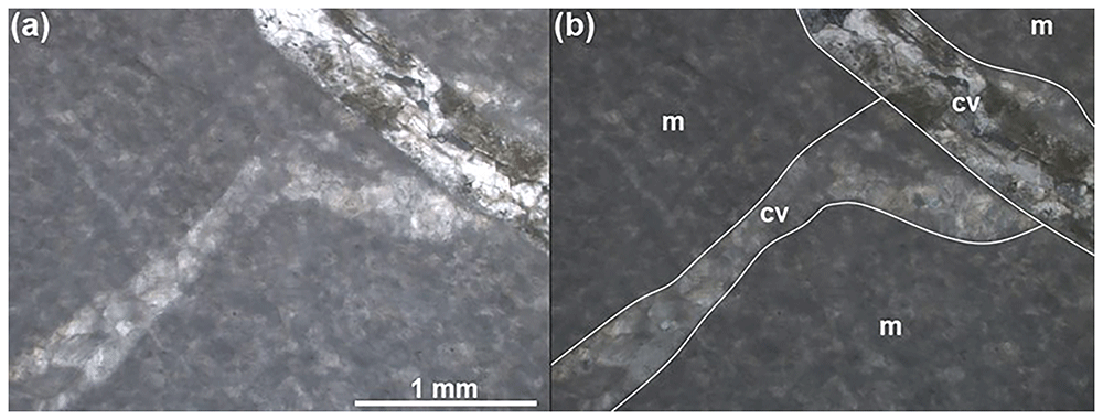
Figure 11. Carbonate veins in southwestern Blomstrandøya.
(a) Uninterpreted non-polarized-light and (b) interpreted polarized-light microscope photograph showing several generations of post-Caledonian carbonate veins in sample 3:6:1B. The veins and marble yielded respectively 32.9 ± 9.9 Ma and 441 ± 24.8 Ma U–Pb ages. Abbreviations: cv: carbonate vein; m: marble.
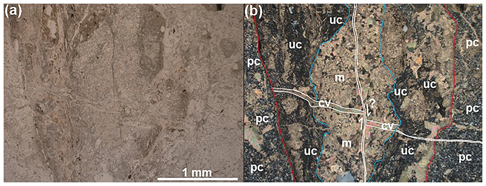
Figure 12. Fault rock along the subvertical WNW–ESE-striking fault at Kapp Guissez.
(a) Uninterpreted non-polarized-light and (b) interpreted polarized-light microscope photograph showing a vein of clay-rich ultracataclasite truncating protocataclastic micaschist of the Signehamna Formation in sample 5:5:5. The ultracataclasite incorporates clasts of marble crosscut by carbonate veins, which yielded a 54.6 ± 3.2 Ma U–Pb age. Abbreviations: cv: carbonate vein; m: marble; pc: protocataclasite; uc: ultracataclasite.
U–Pb geochronology
Sampling. The main challenge during fieldwork was to find suitably oriented deformation structures, i.e., displaying characteristic Timanian strike (WNW–ESE) knowing that such structures would have subsequently been reworked during Caledonian and Eurekan contraction and late Paleozoic and mid–late Cenozoic extension. Thus, to sample carbonate veins for U–Pb analysis, a “forward-casting approach” was adopted. This new approach aims to determine the strike and geometry of structures formed during the event targeted after they were deformed by the subsequent tectonic episodes known to have affected the study area (Figure 13a–e).
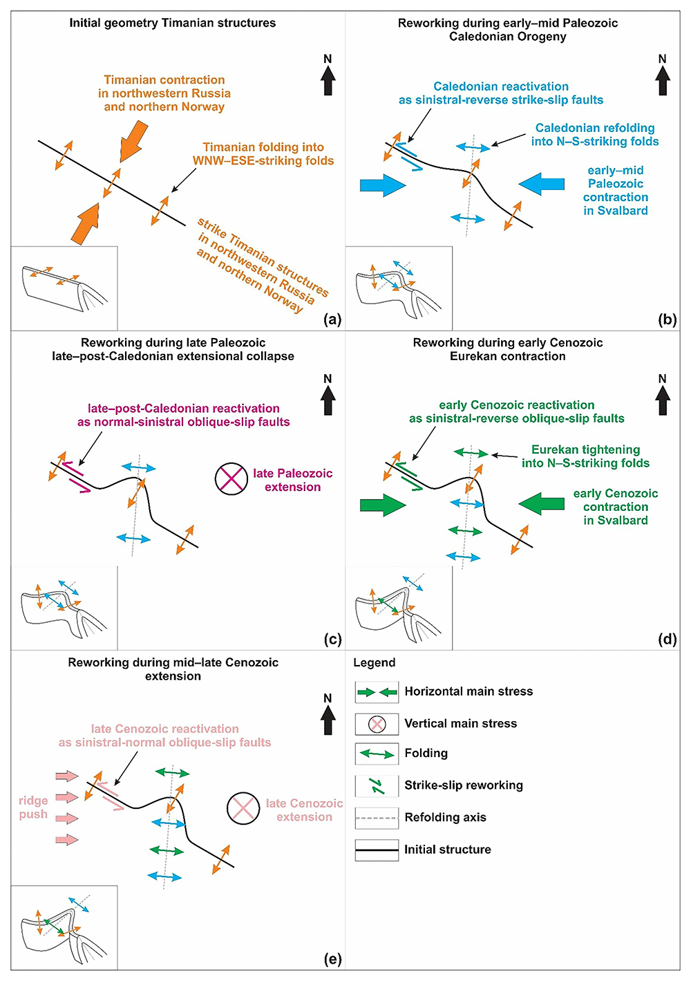
Figure 13. Forward-casting approach.
Sketches detailing the forward-casting approach used to anticipate the geometry of old structures and veins for sampling for geochronological analysis after they were deformed during well-constrained tectonic episodes. Each inset includes a 2D overview and a 3D sketch of the potential geometry of the targeted structures in the lower left corner. (a) Timanian structures developed with an overall WNW–ESE strike and were folded and thrust dominantly top-SSW. (b) During E–W-oriented Caledonian contraction, WNW–ESE-striking Timanian structures were probably reworked by N–S-striking Caledonian folds and thrusts and possibly reactivated as sinistral-reverse faults. (c) During E–W-oriented late–post-Caledonian collapse, WNW–ESE-striking Timanian structures were probably reactivated as normal-sinistral faults. (d) During E–W-oriented Eurekan contraction, WNW–ESE-striking Timanian structures were probably further folded and tightened along the N–S structural axis and possibly reactivated as sinistral-reverse faults. (e) During E–W-oriented mid–late Cenozoic extension, WNW–ESE-striking Timanian structures were probably reactivated as sinistral-normal faults due to ridge push during the opening of the Fram Strait rift. Notice that the overall WNW–ESE strike of the oldest (Timanian) structures remains the same. The structures are locally reoriented due to refolding and locally change oriented to NW–SE or E–W. Note that deformation due to E–W-oriented Svalbardian contraction was not accounted for because of the unlikelihood of this event in Svalbard (Koehl et al., 2022b). Nevertheless, since the main stress of this tectonic event was presumably oriented E–W like Caledonian and Eurekan contraction, the resulting geometry of the targeted structures is not significantly impacted.
A key goal of the study was to test whether the major WNW–ESE-striking fault zone in Kongsfjorden formed during the late Neoproterozoic Timanian Orogeny. Thus, to identify suitable syn-kinematic carbonates, we had to target carbonate veins potentially folded in a WNW–ESE strike as a result of Timanian deformation (Figure 13a). Such veins may as well have been deformed by Caledonian contraction, which is well-known the study area and Svalbard (e.g., Dallmann, 2015; Dallmeyer et al., 1990b; Hjelle, 1979; Ohta et al., 1989; Siggerud, 1963; Thiedig & Manby, 1992), i.e., veins crosscut by Caledonian foliation and involved into N–S-striking folds. Thus, suitable carbonate veins would ideally be (most likely tightly, e.g., isoclinally) folded into 3D folds (Figure 13b). In addition, suitable veins may have been reworked by and/or as partly sinistral strike-slip faults during E–W-oriented, early–mid Paleozoic, Caledonian and early Cenozoic Eurekan contraction and late Paleozoic and late Cenozoic extension (Figure 13b–e). Furthermore, suitable structures are more likely to be relatively small and located away from major fault zones, which have a higher reactivation and overprinting potential. In the study area, this is illustrated by traces of intense brecciation and hydrothermal activity along the main WNW–ESE-striking fault in southern Blomstrandøya (Siggerud, 1963). An ideal sampling location was therefore northern Blomstrandøya, i.e., away from the main fault zone but still part of the same fault system.
Sampling to constrain the timing of early Cenozoic Eurekan and late Cenozoic reactivation–overprinting targeted WNW–ESE-striking, brittle–ductile, sinistral strike-slip faults truncating the Precambrian marbles, Caledonian foliation, and Devonian sedimentary rocks.
U–Pb analysis. U–Pb carbonate analyses were conducted in-situ in polished 80–100 µm thick sections and epoxy mounts at the University of Portsmouth, UK, using an ASI RESOlution© 193 nm ArF excimer laser coupled to an Agilent 8900 triple quadruple (QQQ–) ICP instrument. Samples were analyzed in-situ during 5 analytical sessions in March 2023. Suitable domains with high U (< 1–10 ppm) and low Pb were identified through reconnaissance spot analysis. Carbonate was analyzed using 80 µm spot size, laser fluence of ≈3.5 J/cm2, and a repetition rate of 8 Hz. A 40µm, 10 Hz, 4.5 Jcm2 line on NIST612 glass yields a typical sensitivity of ~1,000,000 cps 238U and a 202Hg background of ~400 cps. U/Th fractionation was typically ~1–6% and Th oxide production was ~0.07–0.13%. There was a 20 s background measurement, followed by 30 s of ablation, and 15 s of washout for each analysis. Four pulses of pre-ablation with a 100 µm spot size and a 15 s washout were used to clean the area before each analysis. Analyzed spot locations can be found in Koehl and Mottram (2024).
NIST SRM 614 was used as the primary reference material for downhole corrections, mass fractionation for Pb, U–Pb drift correction, and U–Pb initial normalization and WC-1 carbonate (254.4 ± 6.4 Ma; 5 ppm U, >90% radiogenic; Roberts et al., 2017; see Koehl and Mottram, 2024) was used for final carbonate U–Pb calibration. Mudtank zircon (~12 ppm U, 732 ± 5 Ma; Black & Gulson, 1978; Jackson et al., 2004) and Duff Brown Limestone (64 ± 2 Ma; Hill et al., 2016) were used as secondary reference material to test long-term reproducibility. Analyses of Duff Brown yielded a 206Pb/238U intercept age of 61.9 ± 1.2 Ma MSWD=1.1 (3.3% from reported age). Mudtank during the analytical period yielded a 206Pb/238U Concordia age of 728.9 ± 2.6 Ma MSWD 0.6 (0.4% from reported age). Two of each reference materials were ablated between every 8 unknowns.
The data were reduced and correcting for instrumental U–Pb drift, downhole fractionation (which was minimal to non-existent), Pb isotope mass bias, U–Pb normalization and peak correction using NIST614 with Iolite©3 software (Paton et al., 2011). A second correction using an in-house spreadsheet was made using the WC-1 reference material to correct for the final matrix-matched normalization, and non-radiogenic Pb (Parrish et al., 2018; correction factor 1.085). Two-sigma uncertainties and include propagated analytical uncertainties, the reproducibility of WC-1 in each analytical session and a 5% uncertainty on the WC-1 RM have been added in quadrature to all data presented in data tables and in plots. Final quoted uncertainties include an additional 3% uncertainty added in quadrature to account for typical long-term reproducibility of analytical equipment and reproducibility 3% of Duff Brown and 0.4% reproducibility of Mudtank. U–Pb data are presented on Tera Wasserburg plots using Isoplot 4.15 (Ludwig, 2003) and IsoplotR (Vermeesch, 2018) with non-common Pb corrected intercept ages reported with two-sigma uncertainties (Figure 14a–c and Table 1).
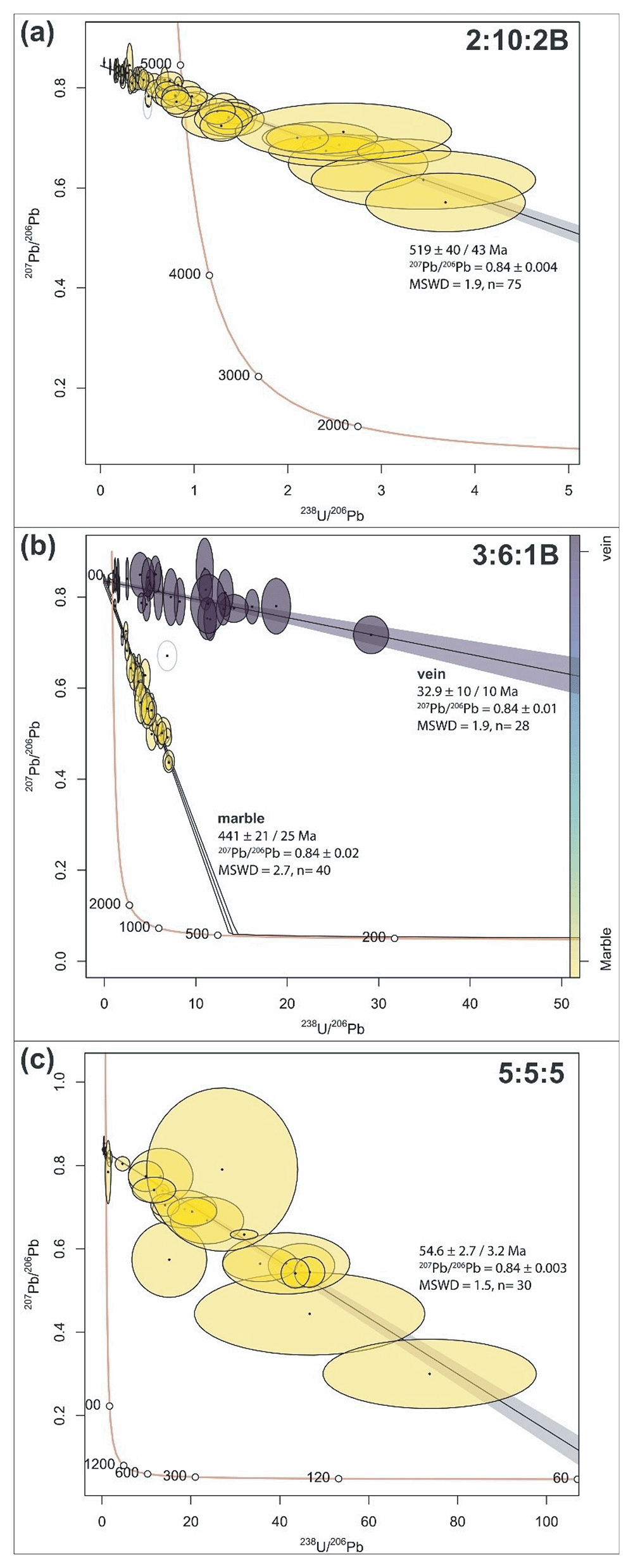
Figure 14. Tera-Wasserburg plots for the dated samples in Kongsfjorden.
U–Pb carbonate Tera-Wasserburg plots (with 2σ uncertainty ellipses) and 206Pb/238U intercept ages for samples (a) 2:10:2B in northwestern Blomstrandøya (mildly folded carbonate veins), (b) 3:6:1B in southwestern Blomstrandøya (carbonate veins and marble), and (c) 5:5:5 at Kapp Guissez (carbonate veins). Abbreviation: MSWD: Mean Squared Weighted Deviation. Quoted 2σ uncertainties are propagated to include reproducibility of the secondary reference materials.
Table 1. U–Pb ages obtained for carbonate veins and marble in Kongsfjorden.
Sample
number | 206Pb/238U intercept
age (Ma) | Uncertainty | Propagated
uncertainty | MSWD | n = |
|---|
| 2.10.2B | 519 | 40 | 42.9 | 1.9 | 75 |
| 3.1.6B_marble | 441 | 21 | 24.8 | 2.7 | 40 |
| 3.1.6B_vein | 32.9 | 9.9 | 9.9 | 1.9 | 28 |
| 5.5.5 | 54.6 | 2.7 | 3.2 | 1.5 | 30 |
Results
Description
In northern Blomstrandøya, carbonate was sampled from (1) boudinaged carbonate veins, which were isoclinally folded in 3D in phyllitic schists, and (2) mildly (open) folded carbonate veins along an E–W-striking fault zone truncating marble (Figure 1d, Figure 3, and Figure 4a–b). The former are involved and folded together with the main N–S-striking foliation along N–S- and WNW–ESE-striking axes and, in places offset by younger brittle fractures that developed along preexisting foliation (Figure 2, Figure 3, Figure 4a–b, and Figure 8a–c). The latter are also involved in the N–S-striking foliation and are part of an E–W-striking fault zone folded along a N–S-striking axis and crosscut by the main foliation (Figure 3, Figure 9a–d and Figure 10a–b). The E–W-striking folded fault comprises tens of cm thick iron-rich, cataclastic fault rock and hundred-µm- to mm-scale carbonate veins that is traced for tens of meters to the east and west (Figure 9a–d and Figure 10a–b). This fault zone is part of the dominant WNW–ESE-striking fault trend in Blomstrandøya and Kongsfjorden (Figure 2). The isoclinally folded veins did not yield any meaningful U–Pb age due to their low uranium content (<0.1 ppm U) and limited extent (i.e., too few spots) and potential contamination by the foliated wallrock. The mildly folded veins crosscut by the E–W-striking folded fault zone yielded a 206Pb/238U intercept age of 519 ± 42.9 Ma (MSWD = 1.9; n=75; Figure 14a and Table 1).
The marbles on Blomstrandøya have a pervasive N–S-striking foliation, which is deformed into dominantly N–S- and subsidiary WNW–ESE-striking folds (Figure 2). The marble adjacent to the NNE-dipping fault zone in southwestern Blomstrandøya yielded a 206Pb/238U intercept age of 441 ± 24.8 Ma U–Pb age (MSWD=2.7; n=40; Figure 14b and Table 1).
In southwestern Blomstrandøya, the marbles of the Generalfjella Formation are crosscut by a meter-wide, moderately NNE-dipping fault zone (Figure 1d and Figure 5a–c). The fault zone exhibits brittle–ductile shear fabrics, including undulating, S–C-like brittle fractures and sigma-clasts (Figure 5c). Three groups of asperities occur along the main planar fault surfaces, one largely horizontal, one vertical, and the other oblique (respectively white, light blue, and light green in Figure 5b). In addition, numerous nearby faults show sinistral strike-slip offset of the bedrock (Figure 6). In map view, the fault includes tens-of-cm- to m-thick lenses of shattered marble, some of which are cemented with carbonate cement (Figure 5a). The fault zone includes several generations of WNW–ESE-striking, µm- to mm-scale carbonate veins displaying crack-seal textures (Figure 11a–b). These veins yielded a 206Pb/238U intercept age of 32.9 ± 9.9 Ma U–Pb age (MSWD=1.9; n=28; Figure 14b and Table 1).
At Kapp Guissez, fracture surfaces strike dominantly WNW–ESE (Figure 2). Among these, a several meters thick, subvertical, WNW–ESE-striking fault zone crosscuts the gently to moderately west-dipping foliation in garnet-rich micaschist (Figure 2 and Figure 7a). The fault zone includes shattered blocks of micaschist bedrock in which the foliation is rotated into steeper dips and reoriented parallel to the fault zone and sigma-clasts (Figure 7a–b). Cm- to tens-of-cm-thick clasts of marble were also incorporated into the fault zone alongside cm- to tens-of-cm-thick, greyish, clay-rich fault gouge (Figure 7b). Carbonate veins crosscutting clasts of marble within cataclastic fault rock yielded a 206Pb/238U intercept age of 54.6 ± 3.2 Ma (MSWD=1.5; n=30; Figure 14c and Table 1). The crystals in the veins showed well-preserved calcite cleavage. The dated calcite veins are truncated by cataclastic fault rock (Figure 12a–b).
Interpretation
Early Cambrian age. Caledonian deformation in Svalbard is constrained to ca. 465–425 Ma (e.g., Dallmeyer et al., 1990b; Faehnrich et al., 2020; Johansson et al., 2004; Johansson et al., 2005; Koglin et al., 2022; Ohta et al., 1989; Ohta et al., 1995). Thus, the 519 ± 42.9 Ma age obtained here for the gently folded and foliated carbonate veins in northern Blomstrandøya does not overlap with Caledonian deformation in Svalbard. In contrast, the age partly overlaps with a major orogenic episode in the Arctic, the ca. 650–550 Ma Timanian Orogeny (Beckholmen & Glodny, 2004; Dovzhikova et al., 2004; Estrada et al., 2018a; Estrada et al., 2018b; Gee et al., 2000; Majka et al., 2008; Olovyanishnikov et al., 2000; Pease et al., 2004; Remizov, 2006; Remizov & Pease, 2004; Rosa et al., 2016). In Svalbard, this orogeny is constrained to ca. 661–540 Ma (Faehnrich et al., 2020; Koglin et al., 2022; Majka et al., 2008; Majka et al., 2012; Manecki et al., 1998; Peucat et al., 1989). The 519 ± 42.9 Ma age is therefore interpreted to reflect late-tectonic fluid flow and crystallization of the folded veins during the final stages of the Timanian Orogeny.
Younger, partly discordant, 40Ar–39Ar, ca. 540–500 Ma ages were obtained for amphiboles in Biskayarhalvøya in northwestern Spitsbergen (Dallmeyer et al., 1990a). These were interpreted to reflect partial resetting due to subsequent Caledonian tectonism (e.g., Schaen et al., 2020; Figure 14a). Recent advances in in-situ 40Ar–39Ar and Rb-Sr dating methods may provide more insight into potential resetting or recrystallisation behavior in these samples (e.g., Gyomlai et al., 2023). The 519 ± 42.9 Ma U–Pb carbonate age yielded here is within this timeframe suggesting potential partial resetting of the isotopic system (e.g., Roberts et al., 2020). However, as the data yields one intercept population with a statistically robust MSWD of 1.9, it is more likely that the limited 238U/206Pb spread along the isochron results in a lack of precision in the dataset. It is therefore unlikely that this carbonate U-Pb age represents partial resetting, but instead late-stage crystallization of vein carbonate.
Other factors further indicate a relationship to the Timanian Orogeny. For example, related carbonate veins are folded isoclinally in 3D along WNW–ESE- and N–S-striking axes (Figure 4a–b and Figure 8a–c). Such geometry is to be expected for structures deformed during two sub-orthogonal orogenic events (Figure 13a–e). Since Caledonian contraction was oriented E–W and resulted into N–S-striking folding and foliation (Hjelle, 1979; Ohta et al., 1989; Siggerud, 1963; Thiedig & Manby, 1992), it is probable that the folding along a WNW–ESE-striking axis derives from NNE–SSW-oriented Timanian contraction (i.e., dated veins perpendicular to σ1). In addition, the dated veins are truncated by the Caledonian foliation, which suggests a pre-Caledonian origin for these veins (Figure 8a–c and Figure 9a–d). The dated folded veins and WNW–ESE-striking faults are therefore interpreted as (late?) Timanian structures.
Silurian age. The 441 ± 24.8 Ma (earliest Silurian) age obtained for the marble of the Generalfjella Formation in Blomstrandøya largely overlaps with that of Caledonian metamorphism in Svalbard (ca. 465–425 Ma; Dallmeyer et al., 1990b; Faehnrich et al., 2020; Johansson et al., 2004; Johansson et al., 2005; Koglin et al., 2022; Ohta et al., 1989; Ohta et al., 1995). It is therefore interpreted as the age of Caledonian metamorphism in the study area. The closure temperature for Pb diffusion in calcite is c. 300–400°C for crystals >100 µm and length scales >1 million years (Cherniak, 1997). The measurable radiogenic Pb in this sample therefore indicates that this metamorphic event likely occurred at <400°C in the greenschist facies. This is supported by the dominance of chlorite and sericite in the phyllitic schist within the marbles of the Generalfjella Formation and partial recrystallization of the marble in Blomstrandøya (Dallmann, 2015; Hjelle, 1979; Siggerud, 1963).
Early Cenozoic age. The subvertical Kapp Guissez WNW–ESE-striking fault zone preserves evidence consistent with sinistral strike-slip movement, including sigma-clasts, lateral offsets along the dated carbonate veins, and the foliation dragged into parallelism with fault zone (Figure 7a–b and Figure 12a–b). The 54.6 ± 3.2 Ma age for the carbonate veins truncating marble clasts directly overlaps with ca. 67–44 Ma 40Ar–39Ar, K–Ar, and U–(Th)–Pb ages for the Eurekan episode in western Spitsbergen (Barnes & Schneider, 2018; Schaaf et al., 2020; Schneider et al., 2018; Tessensohn et al., 2001) and is thus interpreted as the age of early Cenozoic contraction. Sinistral strike-slip kinematics along this WNW–ESE-striking fault during the early Cenozoic are consistent with E–W-oriented Eurekan contraction. The well-preserved calcite cleavage in the dated carbonate suggests that they did not experience metamorphism >300–400°C and, thus, a relatively young (post-Caledonian) event, thus consistent with the early Cenozoic age obtained. The dated calcite veins are crosscut by cataclastic fault rock, which suggests that the fault zone was reactivated subsequently.
Mid–late Cenozoic age. Kinematic indicators along the NNE-dipping fault zone in southwestern Blomstrandøya suggest a protracted tectonic history. The S–C-like brittle fractures may indicate either or both top-SSW and down-NNE movements, whereas the sigma-clasts indicate top-SSW thrusting (Figure 5c). The asperities along the main fault surfaces indicate down-NNE (white asperities and half arrows in Figure 5b), sinistral-normal (green asperities and half arrows in Figure 5b), and sinistral strike-slip brittle faulting (light blue asperities and half arrows in Figure 5b). Since the sigma-clasts are truncated by the calcite-cemented brittle fractures, the 32.9 ± 9.9 Ma vein age is interpreted as the age of down-NNE normal to sinistral strike-slip along the fault. The sinistral movement component is further supported by numerous sinistral offsets and related drag folding along WNW–ESE-striking faults in Blomstrandøya (e.g., Figure 6). This age does not overlap with the ca. 67–44 Ma Eurekan episode in Spitsbergen (Barnes & Schneider, 2018; Schaaf et al., 2020; Schneider et al., 2018; Tessensohn et al., 2001), but is consistent with other studies suggesting a shift to a transtensional/extensional regime from ca. 47–41 Ma (mid Eocene) using U–Pb calcite and (U–Th)/He zircon dating (Barnes & Schneider, 2018; Haaland et al., 2024).
Discussion
Regional correlation of the fault system in Kongsfjorden
Previous studies have suggested the existence of a major WNW–ESE-striking fault in Kongsfjorden, e.g., Kongsvegen fault (Harland & Horsfield, 1974), Kongsvegen fault zone (Harland & Wright, 1979), Kongsfjorden fault zone (Bergh et al., 2000), and Kongsfjorden fault (Piepjohn et al., 2001). Most previous works postulated a south-southwestward dip for this major fault. Some studies suggested it initiated as a Late Devonian Svalbardian thrust (Harland et al., 1993), other as a Carboniferous normal fault (Bergh et al., 2000; Harland & Horsfield, 1974; Piepjohn et al., 2001), and others as an early Cenozoic top-NNE Eurekan thrust (Harland & Horsfield, 1974; Harland & Wrigth, 1979). Many proposed that this potential major fault bends clockwise into a N–S strike to the south in Isfjorden, e.g., Central–West fault zone and Kongsfjorden–Hansbreen fault zone (Harland & Wright, 1979; Harland et al., 1993; Figure 1c).
In contrast, recent interdisciplinary works including regional geophysical datasets in the Barents Sea and Svalbard have uncovered the existence of thousands of kilometers long, WNW–ESE-striking, dominantly NNE-dipping, late Neoproterozoic Timanian thrust systems extending from northwestern Russia to Svalbard (Koehl, 2020; Koehl et al., 2022a; Koehl et al., 2023a). Some of these thrusts, e.g., the NNE-dipping Kongsfjorden–Cowanodden fault zone, extend to Sassenfjorden and Billefjorden in central Spitsbergen (Koehl, 2020; Koehl et al., 2022a; Koehl et al., 2023b; Figure 1b).
The presented structural data in Kongsfjorden show that most fractures dip to the north-northeast (Figure 2). In addition, the largest fault zones in southern Blomstrandøya have a similar north-northeasterly dip (Figure 5a–c). Furthermore, the 519 ± 42.9 Ma age obtained suggests affinities of the studied faults with the Timanian Orogeny. Thus, a correlation is proposed between the WNW–ESE-striking faults in Kongsfjorden and Timanian thrust systems in central Spitsbergen, specifically with the NNE-dipping Kongsfjorden–Cowanodden fault zone (Figure 1b; Koehl, 2020; Koehl et al., 2022a; Koehl et al., 2023b). This suggests that the main fault zone in Kongsfjorden (i.e., between Blomstrandøya and Brøggerhalvøya) dips to the north-northeast and initiated in the late Neoproterozoic (Figure 15).
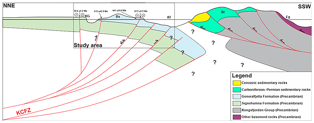
Figure 15. Transect across the Kongsfjorden–Cowanodden fault and West Spitsbergen Fold-and-Thrust Belt.
NNE–SSW-trending transect across the late Neoproterozoic (Timanian) Kongsfjorden–Cowanodden fault zone and early Cenozoic (Eurekan) West Spitsbergen Fold-and-Thrust Belt in Brøggerhalvøya. The Kongsfjorden–Cowanodden fault zone repeatedly uplifted Precambrian metamorphosed basement rocks of the Generalfjella Formation and underlying Signehamna Formation to the south-southwest, which acted as a buttress against relatively soft, unmetamorphosed, post-Caledonian (Carboniferous–Permian and lower Cenozoic) sedimentary rocks, thus forcing the early Cenozoic West Spitsbergen Fold-and-Thrust Belt to bend into a WNW–ESE strike in Brøggerhalvøya. Despite similar rock types in the basement units across Kongsfjorden (dolomite–marble, garnet micaschist, and phyllite), correlations across the Kongsfjorden–Cowanodden fault zone remain uncertain. See location in Figure 1d. Abbreviations: Br: Brøggerhalvøya; Bs: Blomstrandøya; Eg: Engelskbukta; KCFZ: Kongsfjorden–Cowanodden fault zone; Kf: Kongsfjorden; KG: Kapp Guissez.
A NNE-dipping geometry for the Timanian fault system in Kongsfjorden is consistent with the geometry of Timanian thrust systems in seismic transects west of Svalbard (e.g., Koehl, 2025 his figure 4). In addition, it is compatible with the dominantly top-NNE vergence of early Cenozoic Eurekan thrusts onshore Brøggerhalvøya (Bergh et al., 2000; Piepjohn et al., 2001; Saalmann & Brommer, 1997; Saalmann & Thiedig, 2000; Saalmann & Thiedig, 2001; Saalmann et al., 1997), i.e., opposite to that of Timanian thrust systems in Svalbard and the Barents Sea (Koehl, 2020; Koehl, 2025; Koehl & Stokmo, 2024; Koehl et al., 2022a; Koehl et al., 2023a; Koehl et al., 2023b). The studied NNE-dipping Timanian thrust system in Kongsfjorden is tens of km thick (Koehl, 2020; Koehl et al., 2022a; Koehl et al., 2023b), whereas the West Spitsbergen Fold-and-thrust Belt is only a few km thick (e.g., Bergh et al., 2000; Piepjohn et al., 2001). Thus, the major Timanian thrust system in Kongsfjorden and uplifted metamorphic Precambrian basement rocks in the northeast likely acted as a buttress during Eurekan contraction in the early Cenozoic (Figure 15). When Eurekan contraction initiated, dominantly bedding-parallel N–S-striking thrusts formed in post-Caledonian sedimentary rocks in western Spitsbergen (Bergh & Andresen, 1990; Braathen & Bergh, 1995; Dallmann et al., 1993; Maher et al., 1986; Tessensohn, 2001). In Brøggerhalvøya, however, the reactivation of the deep-seated, oblique, NNE-dipping Kongsfjorden–Cowanodden fault zone as a reverse-sinistral fault system (e.g., 54.6 ± 3.2 Ma age) created local stress perturbations. Hence, NNE-verging thrusts formed within shallow, relatively weak, post-Caledonian sedimentary rocks deposited on Brøggerhalvøya (Figure 15).
The speculated WNW–ESE- to N–S-striking Kongsfjorden–Hansbreen fault zone was solely based on stratigraphic and sedimentary discrepancies (Harland et al., 1993). Stratigraphy and sedimentology may be affected by many non-tectonic factors, such as climate, depositional environment, erosion, water depth, and Milankovitch cycles. The present results suggest that the main WNW–ESE-striking fault system in Kongsfjorden and is part of a ≥2000 km long, late Neoproterozoic, NNE-dipping thrust system, the Kongsfjorden–Cowanodden fault zone (Koehl et al., 2022a). Thus, the present results suggest that stratigraphy and sedimentology are inadequate stand-alone tools to resolve tectonic relationships and must be used in conjunction with, e.g., structural fieldwork, geochronological analysis, and geophysical mapping.
Implications for Orogenic Bridge Theory and plate tectonics
Previous studies have shown that Timanian thrust systems extend from northwestern Russia to Svalbard and the western Barents Sea (e.g., Faehnrich et al., 2020; Koehl & Stokmo, 2024; Koehl et al., 2022a; Koehl et al., 2023a; Koehl et al., 2023b; Mazur et al., 2009), and across the presumed Caledonian suture and postulated De Geer Zone (Koehl, 2025; Figure 1b–c). The present study demonstrates that the Kongsfjorden–Cowanodden fault zone, a major late Neoproterozoic Timanian thrust, extends across the entire island of Spitsbergen (Figure 1b and d).
In western Svalbard, Timanian thrust systems, namely the Kongsfjorden–Cowanodden and Kinnhøgda–Daudbjørnpynten fault zones align respectively with the Spitsbergen and Molloy fault zones, major transform faults in the Fram Strait (Figure 1a–b). The present study suggests that the Kongsfjorden–Cowanodden fault zone has repeatedly accommodated sinistral strike-slip movements since the early Eocene. This is suggested by the 54.6 ± 3.2 Ma and 32.9 ± 9.9 Ma U–Pb ages for syn-kinematic carbonate veins along WNW–ESE-striking faults in the study area (Table 1) and related kinematic indicators of sinistral strike-slip movement (Figure 5a–c, Figure 6, and Figure 7a–b). It is also supported by younger cataclastic fault rock crosscutting the dated early Eocene veins at Kapp Guissez, which suggests subsequent (Oligocene or younger?) sinistral strike-slip movements along this fault (Figure 12a–b). A new study on recent earthquakes and associated focal mechanisms in Svalbard suggests that Timanian thrust systems still accommodate sinistral (-normal) movement at present (Koehl et al., 2025 awaiting peer review).
The opening of the Fram Strait is believed to have initiated at ca. 24 Ma (Engen et al., 2008). The 32.9 ± 9.9 Ma age and related sinistral-normal kinematic indicators along a WNW–ESE-striking fault (Figure 5a–c and Figure 6) suggest that continental extension/transtension along inherited, WNW–ESE-striking Timanian thrusts initiated in the earliest Oligocene. This is consistent with recent geochronological data from Haaland et al. (2024), which yielded ca. 41–33 Ma and ca. 13 Ma U–Pb ages for syn-kinematic carbonate veins in western Spitsbergen, and with ca. 47–34 Ma (U–Th)/He ages suggesting a cooling event (e.g., extension-related exhumation) in western Svalbard at that time (Barnes & Schneider, 2018). The similarities in strike, timing, and kinematics of the Kongsfjorden–Cowanodden fault zone in Kongsfjorden with the main transform faults in the Fram Strait suggests that the former controlled the formation of the Spitsbergen fault zone (Figure 1a–b).
The abrupt change from an ENE–WSW- to a NNW–SSE-striking passive margin along the coastline of Norway occurs at the western termination of the Timanian thrust front (Figure 1a; Koehl & Stokmo, 2024; Olovyanishnikov et al., 2000). There, the Mohns Ridge bends c. 90° into the Knipovich Ridge (Figure 1a). The Mohns Ridge opened simultaneously with the Gakkel Ridge in the Arctic Ocean at ca. 56 Ma (earliest Eocene; Faleide et al., 1993; Faleide et al., 2008; Gaina et al., 2002; Srivastana, 1985), i.e., much earlier than the Fram Strait and the Knipovich Ridge (at ca. 24 Ma; Engen et al., 2008).
Despite a couple of failed attempts at incising the thickened Timanian orogenic crust of the Barents Sea in the Hammerfest and Bjørnøya basins (Figure 1a), the northeastern Atlantic rift stepped into the Arctic Ocean, i.e., bypassing numerous oblique, WNW–ESE-striking, dominantly NNE-dipping, Timanian thrust systems in the Barents Sea and Svalbard (Koehl, 2025; Koehl & Stokmo, 2024; Koehl et al., 2022a; Koehl et al., 2023a), which were unsuitable to efficiently thin the crust because of their obliquity to the propagating rift (Koehl & Foulger, 2025 awaiting peer review).
The delayed oceanic opening and breakup in the Fram Strait suggests that the Timanian Orogen has acted as a barrier to rifting and forced the rift to step and reorient. Such an oblique barrier was recently defined as an “orogenic bridge”, i.e., a ribbon of thickened continental crust connecting two continents for prolonged periods while breakup has occurred on either sides (Figure 1a; Koehl & Foulger, 2025 awaiting peer review).
The present work suggests that major transform faults in the Fram Strait formed along inherited, rift-oblique, Timanian thrust systems, which are part of a potential late Neoproterozoic orogenic bridge (Figure 1a). The present results therefore provide ground evidence for Orogenic Bridge Theory, which suggests a controlling relationship of preexisting orogens on rifting and transform faulting (Koehl & Foulger, 2025 awaiting peer review).
Tectonic evolution of Svalbard since the late Neoproterozoic
In the late Neoproterozoic (–early Cambrian?), the Svalbard Archipelago experienced NNE–SSW-oriented Timanian contraction. This resulted in the formation of WNW–ESE-striking, dominantly top-SSW thrust systems, such as the Kongsfjorden–Cowanodden fault zone (present study; Koehl, 2020; Koehl et al., 2022a; Koehl et al., 2023b). At local scale, related WNW–ESE-striking brittle faults, carbonate veins, and folds formed (Figure 3, Figure 4a–b, Figure 8a–c, Figure 9a–d, Figure 10a–b, Figure 16a). This is documented by the 519 ± 42.9 Ma U–Pb age for folded carbonate veins in marbles of the Generalfjella Formation in northern Blomstrandøya, which reflect late Timanian processes (Figure 1d, Figure 3, Figure 9a–d, and Figure 14a, and Table 1).
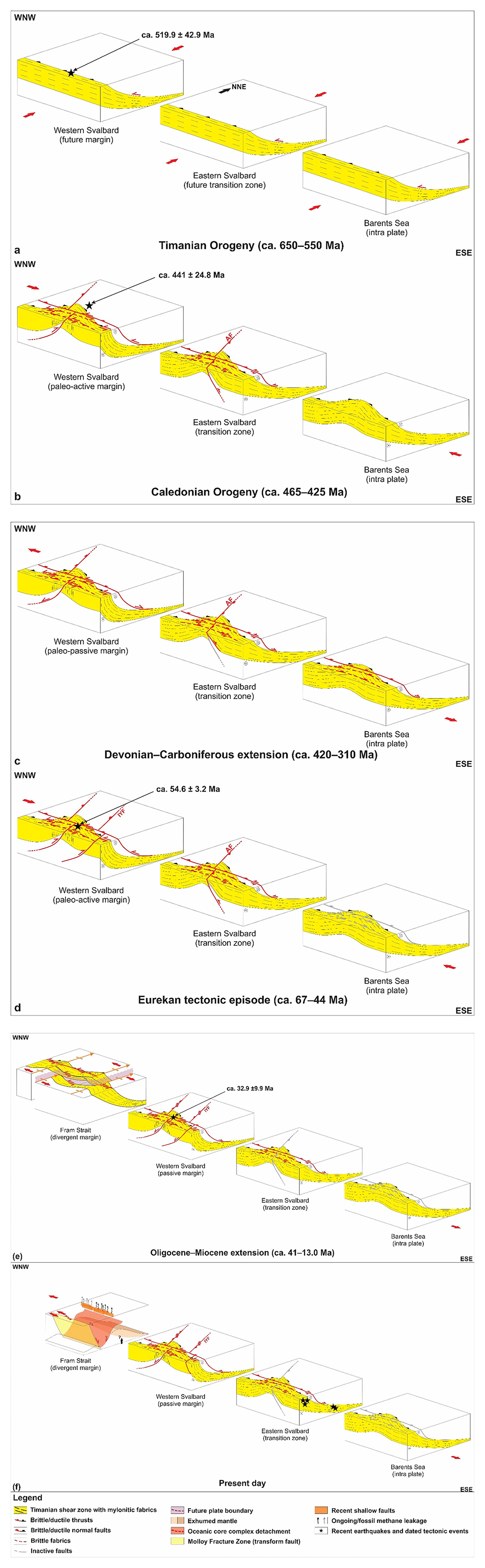
Figure 16. Late Neoproterozoic–present tectonic evolution of Svalbard and the Fram Strait.
(a) NNE–SSW-oriented, late Neoproterozoic Timanian contraction and formation of WNW–ESE-striking, dominantly NNE-dipping thrust systems. (b). E–W-oriented, Middle Ordovician–Silurian Caledonian contraction and reworking of Timanian thrust systems into N–S-striking folds and potential reactivation as sinistral-reverse faults. (c) Devonian–Carboniferous late–post-Caledonian extensional collapse and reactivation of inherited Timanian thrusts as sinistral-normal faults. (d) E–W-oriented, early Cenozoic Eurekan contraction and reactivation of Timanian thrust systems as sinistral-reverse faults. (e) Oligocene–Miocene extension (opening of the Fram Strait) and reactivation of Timanian thrust systems as sinistral-normal faults. Timanian thrust systems localize mantle exhumation (core complex) and the formation of major transform faults in the Fram Strait. (f) Timanian thrust systems are currently reactivated as sinistral-normal faults due to ongoing extension in the Fram Strait. Abbreviations: AF: Agardhbukta Fault; IYF; Isfjorden–Ymerbukta Fault.
In the Middle Ordovician–Silurian, E–W-oriented Caledonian contraction formed N–S-striking folds, thrusts, and foliation (Dallmeyer et al., 1990b; Faehnrich et al., 2020; Hjelle, 1979; Johansson et al., 2004; Johansson et al., 2005; Koglin et al., 2022; Ohta et al., 1989; Ohta et al., 1995; Siggerud, 1963; Thiedig & Manby, 1992). This episode reworked WNW–ESE-striking Timanian thrusts into N–S-striking, dominantly NNE-plunging folds and possibly reactivated them as sinistral-reverse faults (e.g., Gabrielsen et al., 2022; Koehl et al., 2022a; Koehl et al., 2023a; Figure 13a–e and Figure 16b). This is supported by the 441 ± 24.8 Ma U–Pb age for isoclinal geometry of carbonate veins and timing of metamorphism in the marble of the Generalfjella Formation in Blomstrandøya (Figure 1d, Figure 4a–b, and Figure 14b, and Table 1).
In the (latest Silurian?) Devonian–Carboniferous, late–post-Caledonian extensional collapse reactivated Timanian thrust systems as normal-sinistral faults (Braathen et al., 2018; Chorowicz, 1992; Friend, 1961; Friend & Moody-Stuart, 1972; Koehl & Muñoz-Barrera, 2018; Koehl et al., 2023b; McCann & Dallmann, 1996; Murascov & Mokin, 1979; Roy, 2007; Ziemniak et al., 2022; Figure 16c).
In the early Cenozoic, E–W-oriented Eurekan contraction formed dominantly N–S-striking folds, thrusts, and basins (e.g., Central Tertiary Basin; Bergh & Andresen, 1990; Braathen & Bergh, 1995; Dallmann et al., 1993; Koehl, 2021; Koehl et al., 2024; Maher et al., 1986; Steel et al., 1981; Tessensohn, 2001), except in Brøggerhalvøya where Eurekan structures strike WNW–ESE (Bergh et al., 2000; Piepjohn et al., 2001; Saalmann & Brommer, 1997; Saalmann et al., 1997; Saalmann & Thiedig, 2000; Saalmann & Thiedig, 2001; Figure 1b). There, the deep-seated, NNE-dipping Kongsfjorden–Cowanodden fault zone and uplifted Proterozoic basement rocks in the northeast acted as a buttress and forced new early Cenozoic structures to develop obliquely (Figure 15). During this period, Timanian thrust systems and their overprints accommodate most of the (sinistral) strike-slip movement component in Svalbard. This is supported by the 54.6 ± 3.2 Ma U–Pb vein age and sinistral strike-slip kinematic indicators (foliation drag folding) along the subvertical brittle fault zone at Kapp Guissez (Figure 1d, Figure 7a–b, Figure 12a–b, and Figure 14c, and Table 1). Large-scale (c. 400 km) dextral movement along the postulated De Geer Zone west of Spitsbergen was invalidated by the mapping of late Neoproterozoic Timanian thrust systems across its presumed location (Koehl, 2025).
A change to an extensional to transtensional regime occurred in the mid Cenozoic at ca. 47–33 Ma (mid–late Eocene; Barnes & Schneider, 2018, and Haaland et al., 2024), when the opening of the Fram Strait initiated. This is supported by the 32.9 ± 9.9 Ma U–Pb age and sinistral–normal kinematic indicators (e.g., fault surface asperities) in southwestern Blomstrandøya (Figure 1d, Figure 5a–c, Figure 6, Figure 11a–b, and Figure 14b, and Table 1). N–S-striking Caledonian and Eurekan structures were reactivated as normal faults (Haaland et al., 2024), e.g., Hornsund Fault Complex (Koehl, 2025), and Timanian thrust systems as sinistral-normal faults, e.g., Kongsfjorden–Cowanodden fault zone (present study; Figure 5a–c and Figure 6). N–S-striking structure may also have accommodated limited (≤ kilometer-scale) dextral strike-slip movements, e.g., Isfjorden–Ymerbukta Fault (Bergh et al., 1997; Braathen et al., 1999; Harland & Horsfield, 1974; Koehl, 2025). Continuous extensional movements along N–S-striking structures in the mid–late Cenozoic (Haaland et al., 2024) led to crustal thinning, regional mantle exhumation, and development of the Knipovich Ridge, while normal-sinistral movements along Timanian thrust faults led to local mantle exhumation, potential core complexing (e.g., Koehl et al., 2021), and formation of major WNW–ESE-striking transform faults in the Fram Strait, the Molloy and Spitsbergen fault zones (Figure 1a–b and Figure 16e). Timanian thrust systems are still accommodating normal-sinistral movement at present and are responsible for most recent earthquakes around the Svalbard Archipelago (Koehl et al., 2025 awaiting peer review; Figure 16f).









