Introduction
The question of “What is a city?” dates back to ancient philosophers grappling to define its form and function and the corresponding rights of its citizens (Shahidipak, 2022). From a contemporary perspective, cities function more like dynamic ecosystems—interconnected spaces where residents, institutions, and economic actors interact and co-evolve (Batty, 2013). Yet despite their centrality to everyday life and to research across disciplines, one fact remains constant: cities continually reshape themselves in response to changing agglomeration forces. Rapid urban population growth, compounded by nationally varying definitions (Allen et al., 2005; Gregory et al., 2009; Parr, 2007) and divergent disciplinary classifications (Caves, 2005; Chant & Goodman, 1999; Doxiadis, 1970; Paddison, 2001), has vastly outpaced the capacity of policymakers, industries, and researchers to maintain a timely, reliable, and verifiable global list of cities.
Even global entities, like the United Nations, have been struggling to answer that question since 1967 (United Nations, 1969). Over the past five decades, the United Nations Population Division has been compiling a comprehensive demographic account of the global urbanization process, now recognized as the biennial "World Urbanization Prospects". Yet despite these efforts, persistent inconsistencies in national definitions have prevented the creation of a unified global list. For example, the 2018 edition surveyed 233 countries and areas and found that 104 differed in both the number and criteria used to define their own cities (United Nations, 2019).
Part of the challenge on defining what a city is lies in the conceptual instability of the term itself. The term city can be applied to “anything and everything” (Caves, 2005) and is often used interchangeably with terms like urban area, metropolitan region, city proper, urban agglomeration, and capital (UN-Habitat, 2020). This semantic fluidity complicates the task of producing a singular, globally valid definition (UN-Habitat, 2020). A recent study brilliantly summarizes the various definitions of cities and their evolution (Dong et al., 2024).
Rather than defining what a city is, we focus instead on how to create a flexible methodology and verifiable list of cities. We will create a lexicon of settlements based on a new methodology, whereby users can flexibly identify cities as it suits their definition. It will fulfil two urgent needs: an up-to-date verifiable list of cities with their corresponding information (with populations of 50,000 and above1), and an adaptable methodology that allows this lexicon to be expanded with lower population thresholds and continuously updated by anyone with access to the internet. This approach directly responds to UN-Habitat’s need for timely data and metrics (UN-Habitat, 2020). to operationalize any local and/or global policy.
To the best of our knowledge (2024), five datasets (Table 1) exist that list cities across the world. The two most comprehensive and academically sound datasets of cities were created in 2010 (Angel et al., 2016) and in 2015 (Florczyk et al., 2019). New York University and UN-Habitat compiled the first dataset in 2010 as part of the Atlas of Urban Expansion project. This dataset identified 4,231 free-standing cities in 172 countries or territories with populations exceeding 100,000, using spatial criteria based on built-up areas and open spaces, rather than administrative boundaries (Angel et al., 2016). The second is the 2015 Degree of Urbanization (DoU) dataset, created by a consortium of six international organizations, including the European Commission, UN-Habitat, and the World Bank. This dataset employed a 1 km² population grid and density thresholds to delineate urban areas, defining cities as contiguous urban clusters with at least 50,000 inhabitants. As a result, it identified 13,135 cities across 182 countries or territories (Dijkstra et al., 2021).
Table 1. Existing city datasets and their limitations.
Source: The authors.
Name of
the dataset | Organisation | Date of the
used data | Criteria | Number
of cities | Shortcomings |
|---|
1. Cities in
the World | The OECD2 | 2000 – 2015 | Densely populated areas with at
least 50,000 people and 1,500
inhabitants per square kilometre. | 9,028 | The dataset doesn’t include all
countries in the world. |
2. UN data
Database | United Nations
Statistics Division3 | 1970 – 2023 | The government decided
on the list of cities since the
data was collected based on
questionnaires dispatched
annually to national statistical
offices. | 4,968 | The dataset is outdated because
recent government lists have not been
updated, e.g., Lebanon. |
3. World
Cities | Open source4 | March 31, 2023 | Based on authoritative sources
from the USA. | 44,691 | It is non-governmental origin and
solely determined by U.S. government
agencies, potentially limiting its
representativeness and inclusivity. |
| 4. Geonames | Open source5 | November 10, 2023 | All cities with a population
> 1000 or seats of administrative
divisions (ca 80.000). | 141,184 | It is a crowdsourcing scheme with an
interface that allows everyone to sign
in and edit the database, hence false
information can be entered, and such
information can remain undetected. |
5.Urban
Centre
Database | EU6 | 2015 | Based on the Degree of
Urbanisation, employs satellite
remote sensing. It uses small
grid cells to measure human
settlements regardless of
administrative boundaries | 13,135 | This method focuses solely on physical
and spatial attributes, potentially
misrepresenting the functional and
administrative aspects of cities. |
6. The 2010
Universe of
Cities | UN Habitat, New
York University,
Lincoln Institute7 | 2010 | Urban Extent, Built-Up, and
Urbanized Open Space. | 19,289 | The dataset is outdated since it relies on
data from 2010. |
Both methods face implementation challenges. Approaches like the concept of Urban Expansion using remote nighttime images obtained from satellites are not easily translated into administrative and statistical realities on the ground (Angel et al., 2016). Moreover, the authors of the Degree of Urbanization acknowledged that countries still need to implement this method, and only a minority of countries have an official population grid, despite a substantial number of countries preparing a geo-coded census or population register (Dijkstra et al., 2021).
The first method identifies cities based solely on physical features, while the second relies on population data. Recognizing that cities also reflect other factors, several authors have proposed alternative ways to define their boundaries. For example, an exciting new approach to identifying cities has been developed in theory. Dong et al. (2024) proposed using cell-phone datasets, which capture the movement of people and serve as a proxy for the temporal and spatial connections that define urban life. The authors estimate that 7 billion cell-phone users create geolocated data across the world. This data can indicate people’s presence in specific areas and their movement between locations. They suggest that this method has the potential to become widely accepted for delineating cities. However, they do not address the challenge of individuals owning multiple phones or relying exclusively on wireless technology.
In summary, all three methods use an expert-driven, top-down methodological approach: the classification of cities from a top-down perspective, meaning they work with global governmental entities like the United Nations to decide what a city is. They require access to significant amounts of private and/or expensive data and need significant manpower, expertise, and resources to make a list of cities based on the three methodologies. Similarly, to keep the city lists up to date, all of these must be continuously or repeatedly invested. For example, the two city lists mentioned above are severely out of date (the first drawing on a dataset from 2010, the second from 2015). In addition to these three, several other researchers have compiled similar lists (see Table 1), applying varying criteria for what constitutes a city and often capturing only a partial subset of cities worldwide (Yap & Biljecki, 2023).
Despite numerous calls by geographers, demographers, and statisticians for internationally comparable definitions of urban areas and cities, the many different national definitions have not shown any tendency to converge to a common one. International comparability, especially in measuring urbanisation in a particular country, is likely not a major concern for national authorities (Buettner, 2015).
In light of the persistent lack of consensus on what defines a city, we shift the focus from enforcing a universal definition to building a dataset grounded in how cities are defined by individual governments. We argue that the question is no longer what a city is, but how it evolves within its national context. Given the resource constraints and temporal limitations inherent in data collection, pursuing a single, fixed definition has become less relevant than developing a methodology that is adaptable over time. Our approach acknowledges that each government operates with its own criteria—criteria that inevitably shift in response to political, demographic, and spatial change. To accommodate this complexity, we offer a methodology, lexicon, and dataset that are responsive, transparent, and flexible tools designed to support researchers and policymakers alike.
Method
To build our lexicon of cities, we draw on three foundational perspectives. Altshuler emphasizes the governance dimension of cities, highlighting the role of expert planners (Warren, 1967); Jacobs portrays cities as dynamic, evolving ecosystems shaped by everyday human interaction (Jacobs, 1961); and Corburn underscores the importance of local knowledge and participatory processes. Together, these views support a bottom-up understanding of urban classification (Corburn, 2005).
In our lexicon, we identify each self-declared settlement alongside its official website, adopting the definitions and lists provided by local governments. This aligns with the principle of local governance (Ndreu, 2016), where urban status is determined by municipal authorities rather than global institutions. This approach ensures contextual accuracy, official recognition, inclusivity, and currency. Our method triangulates three data sources: dynamic and crowd-sourced platform (i.e., Wikipedia (Wikipedia, 2024), expert-curated databases City Population (Brinkhoff, 2024a), and localized information (using websites of the human settlements) to create a final list.
Creating the lexicon and database contained six steps:
Step 1: To compile data on cities for the Lexicon, we simultaneously examined City Population (Brinkhoff, 2024a) and Wikipedia (Wikipedia, 2024). City Population, managed by Thomas Brinkhoff in Germany, is, to the best of our knowledge, the only website providing comprehensive global city information based on census results and official estimates (Brinkhoff, 2024b). Wikipedia, being crowdsourced, allows for frequent updates by anyone. We compiled the data into an Excel file, grouping countries listed by the United Nation (United Nations, 2025) into world regions as per Angel et al. (2016).
Step 2: We validated the list of cities in each country by initially referring to the region index pages in the City Population database and cross-referencing it with the country’s city list in Wikipedia. Subsequently, we conducted further validation by comparing the final list of country cities with the original data sources listed on both websites.
Step 3: If the lists from the two websites do not match, we check the government’s official documents for verification. Additional scrutiny involved checking the specific Wikipedia page of any extra city identified or other sources such as Google Maps. This process ensures the existence of the city. Moreover, if the source of information could not be verified on the City Population or Wikipedia websites, we only considered the list from the website with a verified reference source, and that source was further validated (e.g., Cambodia).
Step 4: If the years of the population numbers differ between the two websites, we select the latest available census or estimated population list. Moreover, during our data verification process, we may discover that the country has updated its city list on its official government website. However, this updated list may not have been reflected on the two websites we referenced. In such cases, we prioritized the list sourced directly from the government website, ensuring that we incorporated the most accurate and up-to-date information available (e.g., Thailand).
Step 5, for each city included in the final list, we documented its administrative level, identifying whether it was classified as a municipality, district capital, special-status city, or another type of administrative unit. This information was obtained either directly from the country’s official government list or from the city’s official website, depending on availability.
Finally, we used Google search to find the official website, alongside cross-referencing with the City Population and Wikipedia pages, ensuring that the website is indeed the city’s official site. (See Workflow diagram 1). The websites of US cities were adopted from Cai et al. (2023).
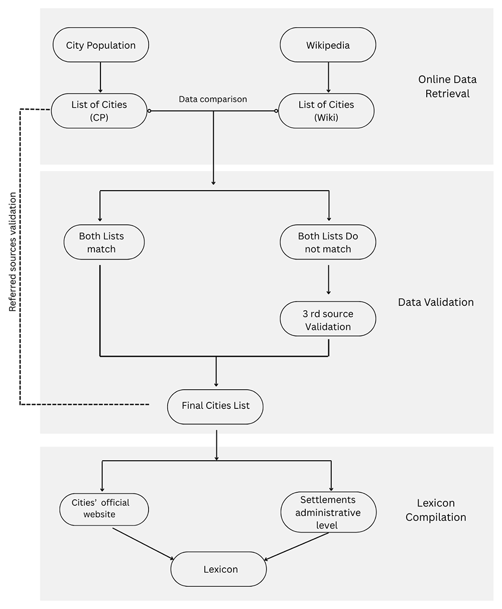
Workflow diagram 1. Illustrates the logic, operations, and decisions involved in the compilation and validation processes of compiling the lexicon.
Source: The authors.
Limitation
A core challenge in developing a global dataset through open-source platforms lies in their heavy reliance on predominantly Western-oriented sources, especially the English-language version of Wikipedia. This dependence raises valid concerns about representativeness and inclusivity—particularly in regions where Wikipedia content is censored or inconsistently developed across languages (see: Censorship of Wikipedia). To address this, we mitigated the bias by triangulating data from government websites and expert-curated databases.
Data availability
Zenodo repository: “World Cities Lexicon – Urban Administrative Units and Population Data” https://zenodo.org/records/16419786. (Karam et al., 2025)
This project contains following underlying data:
LexiconDataset_25072025.xlsx Contains major cities across world regions with their administrative classification, population data, official digital presence, and relevant geographic identifiers.
Data are available under the terms of the Creative Commons Attribution 4.0 International license (CC-BY 4.0) (https://creativecommons.org/licenses/by/4.0/).
Contribution
We do not claim that our dataset is exhaustive, nor do we offer a silver bullet for the persistent challenge of defining what constitutes a city. Instead, we provide a replicable method to construct and validate a flexible, globally relevant dataset. We contribute to global comparability by clarifying how cities are defined and designated in different national contexts. Through the compilation of a lexicon that documents country-specific criteria, thresholds, and classification systems, the study equips users to better interpret the variation in how cities are recognized worldwide. This transparency enables more informed, purposeful sampling in cross-national research and policy development. In doing so, the lexicon promotes comparability not by enforcing sameness, but by rendering visible the diversity embedded in urban definitions making it accessible to researchers, practitioners, and policymakers alike.
A natural question arises: if an official list of cities, such as those from national census data, is available, why not use it directly as the foundation for the lexicon, given its presumed authority? However, locating and interpreting official government data is often challenging and time-consuming, especially when sources are available only in local languages unfamiliar to the researchers. In our dataset, when the lists from Wikipedia and City Population align, compiling the information becomes straightforward and efficient. But when discrepancies arise, cross-referencing the citations and references in Wikipedia or City Population can provide useful entry points, as either source may link to a more accurate or accessible government source.
Acknowledgement
We would like to extend our sincere gratitude to the following individuals for their invaluable contributions to compile the lexicon: Ánh Minh Nguyen, Dacheng Lu, Dinah Theresia Buhr, Ezra Garcia, Ines Wich, Kristian Mayer, Marie Kühn, Ngoc Trinh Nguyen, and Pardis Safarafard.
Faculty Opinions recommendedReferences
- Allen J, Massey D, Pile S:
City worlds. Routledge, 2005. Publisher Full Text
- Angel S, Blei A, Parent J, et al.:
Atlas of urban expansion: the 2016 edition, volume 1: areas and densities. NYU Urban Expansion Program, UN-Habitat, & Lincoln Institute of Land Policy, 2016. Reference Source
- Batty M:
The new science of cities. The MIT Press, 2013. Publisher Full Text
- Brinkhoff T:
City population. 2024a. Reference Source
- Brinkhoff T:
City population—help & information. City Population Help & Information, 2024b. Reference Source
- Buettner T:
Urban estimates and projections at the United Nations: the strengths, weaknesses, and underpinnings of the world urbanization prospects.
Spat Demogr.
2015; 3(2): 91–108. Publisher Full Text
- Cai M, Huang H, Decaminada T:
Local data at a national scale: introducing a dataset of official municipal websites in the United States for text-based analytics.
Environ Plan B: Urban Anal City Sci.
2023; 50(7): 1988–1993. Publisher Full Text
- Caves RW:
Encyclopedia of the city. Taylor & Francis, 2005. Reference Source
- Chant C, Goodman D:
European cities and technology: industrial to post-industrial cities. Routledge, 1999. Reference Source
- Corburn J:
Street science: community knowledge and environmental health justice. The MIT Press, 2005. Publisher Full Text
- Dijkstra L, Florczyk AJ, Freire S, et al.:
Applying the degree of urbanisation to the globe: a new harmonised definition reveals a different picture of global urbanisation.
J Urban Econ.
2021; 125: 103312. Publisher Full Text
- Dong L, Duarte F, Duranton G, et al.:
Defining a city—Delineating urban areas using cell-phone data.
Nat Cities.
2024; 1(2): 117–125. Publisher Full Text
- Doxiadis CA:
Emergence and growth of an urban region the developing urban detroit area volume 3: a concept for future development. Detriot Edison Co., 1970. Reference Source
- Florczyk A, Melchiorri M, Corban C, et al.:
Description of the GHS urban centre database 2015. JRC Publications Repository, February 4, 2019. Publisher Full Text
- Gregory D, Johnston R, Pratt G, et al.:
The dictionary of human geography. (6th edn.). Wiley-Blackwell, Chichester, 2009. Reference Source
- Jacobs J:
Death and life of Great American cities. Random House, 1961. Reference Source
- Karam H, Phatthanachaisuksiri L, Palliyil V:
World cities Lexicon – urban administrative units and population data.
Zenodo.
2025. http://www.doi.org/10.5281/zenodo.16419786
- Ndreu A:
The definition and importance of local governance.
Social and Natural Sciences Journal.
2016; 10(1). Publisher Full Text
- Paddison R, (Ed.): Handbook of urban studies. SAGE, 2001. Reference Source
- Parr JB:
Spatial definitions of the city: four perspectives.
Urban Stud.
2007; 44(2): 381–392. Publisher Full Text
- Shahidipak DM:
Philosophy of democracy, shaping city in ancient Greece by Plato and Aristotle. 2022; 1(1): 25–29. Reference Source
- UN-Habitat:
What is a city? UN-Habitat, 2020. Reference Source
- United Nations:
Growth of the world’s urban and rural population, 1920–2000 (44; POPULATION STUDIES). Department of Economic and Social Affairs, 1969. Reference Source
- United Nations:
World urbanization prospects the 2018 revision. 2019. Reference Source
- United Nations:
Member states. United Nations, 2025. Reference Source
- Warren R:
Altshuler, Alan A., The city planning process: a political analysis.
Nat Res J.
1967; 7(4): 666. Reference Source
- Wikipedia:
Lists of cities by country. February 29, 2024. Reference Source
- Yap W, Biljecki F:
A global feature-rich network dataset of cities and dashboard for comprehensive urban analyses.
Sci Data.
2023; 10(1): 667. PubMed Abstract
| Publisher Full Text
| Free Full Text