Introduction
Iceland straddles the divergent boundary between the North American and Eurasian plates, where the plate boundary overlies an upwelling mantle plume (Einarsson, 2008; Hjartarson et al., 2017; Jakobsson and Gudmundsson, 2008). Its unique setting gives rise to a big diversity of hydrothermal systems, ranging from terrestrial high-temperature springs and fumaroles, to underwater shallow-water hydrothermal vents such as the Strýtan vent (Gutiérrez-Ariza et al., 2024; Marteinsson et al., 2001; Price and Giovannelli, 2019; Stefánsson et al., 2021). The interaction between active volcanism and groundwater circulation supports diverse microbial ecosystems, providing a large range of physicochemical gradients (Friðleifsson et al., 2017; Twing et al., 2022). In Iceland, hydrothermal systems span a broad range of pH and temperature conditions, from acidic solfataras to alkaline carbonate chimneys, and are enriched in dissolved gasses (e.g., CO2, H2, CH4), and trace metals (e.g., Fe, Mn, Cu) (Geptner et al., 2002; Stefánsson et al., 2021; Szponar et al., 2013). Such gradients cause strong redox disequilibria that fuel chemolithotrophic microbial metabolisms, including hydrogen oxidation, methanogenesis, and sulfur cycling (Dahle et al., 2015; Torsvik et al., 2015). As a result, Icelandic hydrothermal sites represent rare natural laboratories for studying microbes–mineral interactions, biogeochemical cycles, and the limits of life in extreme environments (Früh-Green et al., 2003; Fullerton et al., 2021; Martin and Russell, 2006).
Beyond their ecological importance, Icelandic environments have been proposed as analogues for early Earth conditions and for potential habitable niches on other planetary bodies (Sojo et al., 2016). Studying the microbial communities that these places host across multiple geothermal sites bridging large geological scales allows one to capture a more comprehensive view of how environmental heterogeneity influences and shapes microbial diversity, community structure, and metabolic potential (Giovannelli et al., 2022).
The ISL23 expedition was designed to investigate the Icelandic microbial diversity and its interactions with the geology by sampling a wide range of hydrothermal systems, including shallow-sea chimneys, hot springs, and fumarolic fields. This report describes the methods and the sites sampled during the ISL23 expedition, which is part of a project that, by combining geochemical analyses with microbial community profiling, aims to improve our understanding of the complex interplay between geological activity and microbial life.
Expedition team and logistics
The project team is composed of interdisciplinary scientists spanning the fields of microbiology, biogeochemistry, microbial ecology, gas geochemistry and science communication. The expedition logistics was facilitated by the University of Iceland. Access to the cabins and direct contact with land owners was provided through the University of Iceland. The Field Science Party was responsible for sample collection and the field measurements. The remote location of some springs and the lack of roads and paths on the island, required extensive planning with reasarchers of the University of Iceland for the logistics, preparation of the expedition and to understand the best way to reach the sites, in particular the ones in the center of Iceland. To reach these sites it was necessary to use 4x4 vehicles with high clearance and equipped with winter-rated all-season tires. Access to site SC_230907 requires a boat and diving equipment for cold water conditions. The dive is technical and we were supported by the Strýtan Dive Center.
Field Science Party composition: Francesco Montemagno, Annarita Ricciardelli, Feliciana Oliva, Martina Cascone, Namitha Kumar, Maarten de Moor, Jacopo Pasotti, Carlos José Ramírez Umaña, Roy Price, Snaedis Bjornsdottir, Ingi Agnarsson, Sæmundur Ari Halldórsson and Donato Giovannelli (Expedition Leader and PI of the project).
Support Science Party composition: Angelina Cordone, Jake Lowe, Antonino Pollio, Peter Barry and Andri Stefansson.
Geological and environmental background
Iceland sits atop the Eurasian-North American divergent plate boundary and a mantle plume (Einarsson, 2008; Eiríksson and Símonarson, 2021), resulting in the extensive volcanism and basaltic flows which characterize this unique geological setting. Relative motions between the two features lead to oblique faulting, fissuring, and a general eastward shift of volcanic zones over time volcanic activity is more intensive where these phenomena cut across the plate boundary (Stefánsson et al., 2017).
Basaltic volcanism transports mantle volatiles to the surface, including carbon, sulfur, noble gases, and halogen species (Ranta et al., 2023). Typically, seawater at mid-ocean ridges dominates other possible sources of volatiles (Stefánsson et al., 2017); the subaerial setting of Iceland’s divergent plate boundary means volcanic hydrothermal systems can be used to investigate alternative volatile sources, and to gauge the contribution of degassing intrusions to volatile release (Ranta et al., 2023; Stefánsson et al., 2017).
Each neovolcanic rift zone has its own distinct He isotope signature (West Rift Zone: 12–17 Ra, the ratio of 3He/4He is reported relative to the ratio of air (Ra); North Rift Zone: 8–11 Ra; East Rift Zone: 18–21 Ra), suggested to mark the location of past and present plume activity (Harðardóttir et al., 2018). Such high ratios have been associated with un-degassed and primordial mantle sources (Füri et al., 2010; Harðardóttir et al., 2018), and together with estimates for pre-eruptive carbon isotope signatures (δ13C values from neovolcanic zone basalts) suggest close resemblance to primary mantle composition (Barry et al., 2014). However, a large range of δ13C values measured across fluid samples across Iceland suggests that hydrothermal processes extensively modify the original source composition through degassing and/or crustal assimilation (Barry et al., 2014). The extent to which microbial processes might further contribute to altering the mass balance of volatiles recycled through the crust as demonstrated in other locations globally (e.g. Costa Rica and South America (Barry et al., 2025, 2022; Fullerton et al., 2021)).
Geothermal activity in Iceland is classified by high- and low-temperature systems, the former are typically associated with volcanism within its neovolcanic zones, such as the EVZ and NVZ, and the latter with active fractures and faults which are widespread across Quaternary and Tertiary formations (Stefánsson et al., 2017) (
Figure 1). Geothermal fluids are characterized by a wide range in carbon isotope ratios CO2/3He values. Extreme geothermal values suggest that original source compositions have been extensively modified by hydrothermal processes such as degassing and/or calcite precipitation. Relatively low δ13C and CO2/3He values in low-temperature zones are consistent with calcite precipitation as a dominant process in older portions of the Icelandic crust (Barry et al., 2014). High-temperature regions demonstrate maximum δ13C and CO2/3He values, with orders of magnitude higher for fluids, relative to gas-phase samples suggesting that hydrothermal phase separation processes may be prevalent in these zones (Barry et al., 2014).
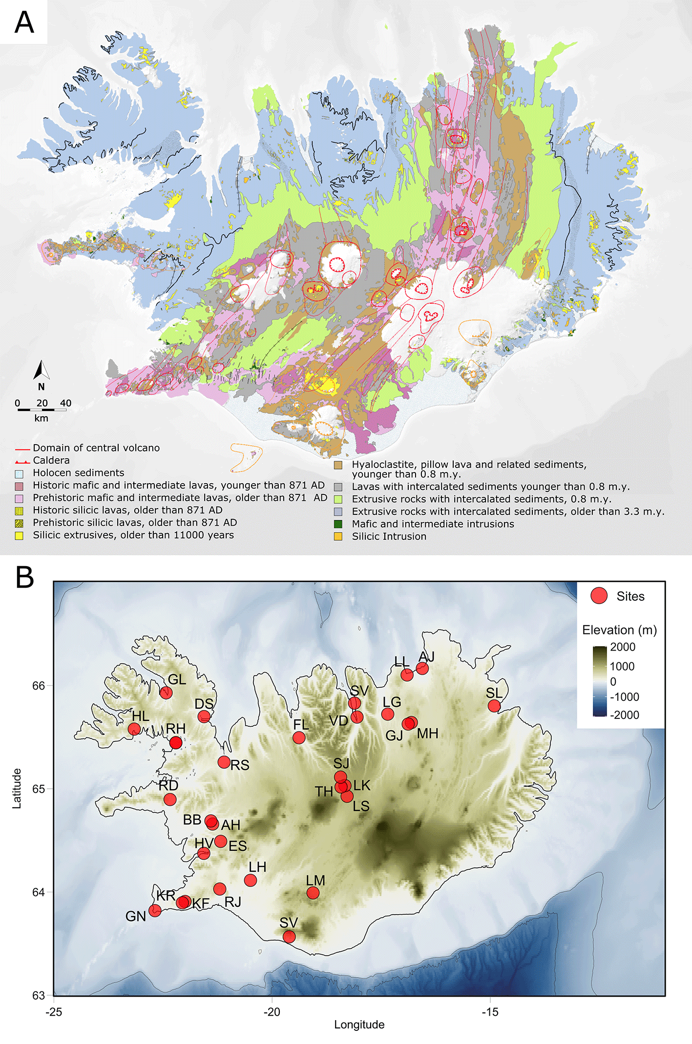
Figure 1. Geological map of the bedrock of Iceland (A) and location of the sites sampled (see
Table 1) during the ISL23 expedition (B).
Red circles mark the sites sampled during the expedition. The geological map was modified from the Natural Science Institute of Iceland (Jóhannesson, 2014 “Geological maps | Náttúrufræðistofnun”). The basemap shows shaded relief topography and surrounding bathymetry; colors indicate elevation (m), from −2000 (dark blue) to +2000 (tan/green).
Table 1. Location and principal physico-chemical characteristics of the sampled sites.
NA - Fluid flux not available. No flow - no visible flow of fluids from the source visible for measurements.
|
Collection ID |
Site name |
Sampling date |
Latitude
(°N) |
Longitude
(°E) |
Elevation (m) |
Temp (°C) |
pH |
Fluid flux (L/s) |
SPC (mS/cm) |
ORP (mV) |
DOsat (%) |
DO (ppm) |
TDS (ppm) |
Sal (%) |
TA (ppm) |
Sulfide (ppb) | Fe2+ (ppb) |
|---|
| KF_230826 | Kleifarvatn | 2023-08-26 | 63.9082429 | −21.9950715 | 138 | 66 | 5.9 | NA | 0.955 | −44.1 | 21.8 | 1.99 | 480 | 0.05 | 36 | NA | NA |
| KR_230828 | Krýsuvik | 2023-08-28 | 63.8954748 | −22-0570171 | 170 | 78 | 2.1 | no flow | 12.08 | 6.6 | 22 | 1.11 | 6,000 | 0.66 | 0 | 11,700 | 2,950 |
| GN_230828 | Gunnuhver | 2023-08-28 | 63.8194083 | −22.6846433 | 17 | 72 | 2.14 | no flow | 13.98 | 34 | 10.7 | 0.58 | 6,992 | 0.78 | 0 | 0 | 4,060 |
| RJ_230829 | Reykjadalur | 2023-08-29 | 64.028994 | −21.1996159 | 128 | 69.5 | 6.98 | 0.15 | 0.86 | 2.8 | 52.3 | 2.85 | 430 | 0.04 | 126 | 6 | 0 |
| LH_230829 | Laugarás | 2023-08-29 | 64.1129167 | −20.4958392 | 59 | 80 | 9.38 | 17.4 | 0.81 | −2.6 | 29.4 | 1.57 | 408 | 0.04 | 150 | 169 | 39 |
| LM_230830 | Landmannalaugar | 2023-08-30 | 63.9915483 | −19.0627467 | 597 | 60 | 6.18 | 406 | 1.09 | 10.5 | 14.9 | 0.73 | 545 | 0.05 | 255 | 131 | 1,890 |
| SV_230831 | Seljavallalaug | 2023-08-31 | 63.5661483 | −19.6079383 | 76 | 57.5 | 7.75 | 0.24 | 1.96 | 14.3 | 34.3 | 2 | 979 | 0.10 | 270 | 0 | 34 |
| HS_230901 | Hvammsvík | 2023-09-01 | 63.5661483 | −19.6079383 | 25 | 91.3 | 8.93 | 16.75 | 1.09 | −22.2 | 7.1 | 0.4 | 544 | 0.05 | 78 | 1,810 | 42 |
| ES_230901 | Englandshverir | 2023-09-01 | 64.4905648 | −21.179099 | 178 | 78 | 9.17 | 7 | 0.62 | −3.1 | 37.8 | 2.03 | 314 | 0.02 | 114 | 382 | 28 |
| AH_230901 | Árhver | 2023-09-01 | 64.6584216 | −21.3639612 | 29 | 57 | 9.16 | NA | 0.46 | 2.6 | 97.6 | 7.13 | 232 | 0.02 | 75 | 420 | 343 |
| BB_230902 | Borgarbyggð | 2023-09-02 | 64.6883977 | −21.4028918 | 41 | 99.8 | 9.2 | 18 | 0.80 | −0.3 | 12 | 0.64 | 401 | 0.04 | 109 | 1,970 | 221 |
| RD_230902 | Rauðamelsölkelda | 2023-09-02 | 64.8956115 | −22.3388239 | 107 | 10.53 | 4.53 | no flow | 0.18 | 13.6 | 45.4 | 4.7 | 90 | 0.01 | 27 | 0 | 178 |
| RS_230903 | Reykjaskóli | 2023-09-03 | 65.2577603 | −21.100458 | 19 | 86.9 | 9.12 | 5 | 2.86 | 10.3 | 60.4 | 3.44 | 1430 | 0.14 | 36 | 47 | 930 |
| RH_230904 | Reykhóar | 2023-09-04 | 65.4456505 | −22.2064709 | 12 | 82 | 9.4 | NA | 0.53 | 2.1 | 58.8 | 3.51 | 268 | 0.03 | 96 | 0 | 117 |
| DS_230904 | Drangsnevegur | 2023-09-04 | 65.6479000 | −21.6429000 | 11 | 79.6 | 8.99 | 2.1 | 0.964 | 5.3 | 38.6 | 2.29 | 482 | 0.046 | 63 | 350 | 0 |
| HL_230905 | Hellalaugur | 2023-09-05 | 65.5776628 | −23.1597213 | 10 | 39.5 | 9.99 | 4.8 | 0.261 | −3.6 | 54 | 3.55 | 130 | 0.012 | 73.5 | 0 | 20 |
| GL_230905 | Gamla Laugin | 2023-09-05 | 65.9290867 | −22.428785 | 6 | 84.4 | 8.19 | NA | 6.365 | 14.7 | 49.3 | 3.21 | 3182 | 0.34 | 30 | 9 | 590 |
| FL_230906 | Fosslaug | 2023-09-06 | 65.4941967 | −19.3836483 | 49 | 68.5 | 10 | NA | 0.618 | −0.8 | 53.6 | 3.39 | 309 | 0.029 | 132 | 64 | 10 |
| SC_230907 | Strýtan vent cone | 2023-09-07 | 65.828852 | −18.111779 | −23.5 | 72 | 9.5 | NA | 33.28 | 12.6 | 59.4 | 4.98 | 16.64 | 2.092 | 189 | 166 | 12 |
| LG_230907 | Laugar | 2023-09-07 | 65.7225747 | −17.3505889 | 163 | 53.5 | 10.4 | 0.4 | 0.511 | 21.7 | 96.6 | 5.66 | 256 | 0.024 | 159 | 0 | 15 |
| LL_230908 | Lón lake | 2023-09-08 | 66.1020433 | −16.9077 | 5 | 10.77 | 8.26 | NA | 0.231 | 8.2 | 126.9 | 13.43 | 116 | 0.011 | 72 | 19 | 76 |
| MH_230908 | Mývatn Námaskarð Hverir | 2023-09-08 | 65.6415088 | −16.8090939 | 369 | 85 | NA | no flow | NA | NA | NA | NA | NA | NA | NA | 0 | NA |
| SL_230909 | Selárdals laug | 2023-09-09 | 65.8023317 | −14.9095317 | 63 | 53 | 10.12 | 4 | 0.378 | −5.2 | 0 | 0 | 189 | 0.017 | 109.5 | 43 | 0 |
| AJ_230909 | Æerlækjarsel | 2023-09-09 | 66.1652014 | −16.5584453 | 6 | 88 | 7.77 | no flow | 11.26 | 25 | 30.5 | 1.85 | 5629 | 0.624 | 42 | 0 | 23 |
| GJ_230910 | Grjótagjá | 2023-09-10 | 65.6264991 | −16.882801 | 302 | 48.7 | 8.2 | no flow | 0.831 | 17 | 1.5 | 0.08 | 415 | 0.039 | 105 | 21 | 58 |
| VD_230911 | Vaðlaheiðargöng | 2023-09-11 | 65.6942367 | −18.0543738 | 72 | 47.7 | 9.87 | NA | 0.392 | −5.3 | 108.5 | 6.13 | 196 | 0.018 | 153 | 0 | 26 |
| LS_230912 | Laugafell South | 2023-09-12 | 64.9271304 | −18.282252 | 765 | 31 | 10.08 | NA | 0.24 | −8.9 | 25.7 | 1.69 | 120 | 0.011 | 79.5 | 6 | 7 |
| TH_230912 | Þuríðarhver (Thuridahver) | 2023-09-12 | 65.0302351 | −18.3305599 | 757 | 43.2 | 10.03 | NA | 0.243 | −11.9 | 26.7 | 1.41 | 121 | 0.011 | 100.5 | 0 | 0 |
| SJ_230913 | Sesseljubær | 2023-09-13 | 65.1127117 | −18.431581 | 648 | 10.3 | 9.65 | NA | 0.052 | 15.7 | 74.9 | 8.35 | 26 | 0.002 | 90 | 10 | 14 |
| LK_230913 | Laugakvísl | 2023-09-13 | 65.024425 | −18.3319267 | 724 | 40.3 | 9.67 | NA | 0.12 | 1.8 | 44 | 2.65 | 60 | 0.005 | 36 | 0 | 5 |
Sampling methods
Sample selection
Fluids, sediments and gases were collected from 30 locations identified based on the literature and the knowledge of the researcher of the University of Iceland. Several of the springs show characteristics compatible with the definition of deeply-sourced seeps (Giovannelli et al., 2022). We identified the main seep outlet by using a combination of field observation and measurements, as pH, temperature, conductivity and the use of a thermal camera. The aim of this approach is to sample pristine gasses and fluids as they emerge from the subsurface, minimizing their interaction with the surface environment. We also sampled background soil samples in the proximity of each site, choosing a close point that did not show geothermal alterations. This type of sampling approach, described in detail in Giovannelli et al. (2022), aims to maximize the subsurface information that can be extrapolated from the data. Temperature, conductivity, pH, redox potential, total suspended solids and dissolved oxygen were measured directly in the field using a Hanna Multiparameter probe (HANNA, HI98196, accuracy: ±0.15°C, ±0.02 pH), regularly calibrated. Water emission rates were estimated by measuring the spring outlet dimensions and the water flow velocity using a FL-K1 stream flow metre, handheld rod with impeller and LCD readout (JDC Instruments Electronics Flowatch Flowmeter). Alkalinity, iron (II) and dissolved hydrogen sulfide were also measured in the field as described below.
Geochemistry samples acquisition
Aqueous and Sediment Geochemistry
When possible, we took sediment samples as close as possible to the water outlet point, and collected them into 50 ml metal-free conical tubes. For the characterization of the major dissolved ions, 0.22 μm filtered fluids were collected in a 50 ml conical tube (Correggia et al., 2024a). For the analysis of trace elements, a duplicate sample was collected in acid-washed tubes and acidified with nitric acid 2% final concentration to avoid the precipitation of metals (Correggia et al., 2024). Filtered fluids (0.22 μm) were also collected in a 10 ml penicillin vial air-free for dissolved inorganic carbon isotope composition.
Dissolved and free gas geochemistry
Fluids were collected both for gas composition analysis, stable isotope of the carbon pools (δ13C of CO2, dissolved inorganic carbon and organic carbon) and water (d18O and D) and noble gas isotope systematics. Fluid samples for noble gas analysis were first flushed through silicone tubing and into 3/8-inch copper tubes. After sample flushing (i.e., approximately 10x the volume of the tubing), stainless steel clamps were closed on each end of the copper tubes, trapping the fluid sample inside of the copper tubing between the clamps (Barry et al., 2022). Fluids to be analyzed for dissolved gas compositions were collected in pre-evacuated 250 ml Giggenbach bottles as previously described (Barry et al., 2019). At sites where a free gas phase was present, copper tubes were also used to collect free gas for noble gas isotope analysis using a funnel to collect the gases. Gases were concentrated using an inverted funnel and silicone tubing and after flushing the sampling line with gas for approximately 30 minutes, clamps were closed. Free gas for major and trace gas analysis was collected using Giggenbach bottles containing 4 M NaOH to remove CO2 from the gas phase and allowing trace gas to accumulate (de Moor et al., 2013).
Determination of total Alkalinity, dissolved sulfide and iron (II) in geothermal fluids
Ferrous iron (Fe2+), sulfide (S2−), and dissolved silica (SiO2) concentration, as well as alkalinity, were measured immediately after sampling to minimize oxidation and precipitation processes. Fluid aliquots were filtered through 0.22 μm membranes.
Iron (Fe2+) concentration was determined colorimetrically using the Hach test kit based on the ferrozine method, in which Fe2+ forms a complex with ferrozine, which was then measured using the Hach DR1900 portable spectrophotometer. Concentrations were calculated from a calibration curve prepared with FeSO4 standards. Sulfide (S2−) was quantified using the methylene blue method, also implemented in the Hach field kit. Sulfide reacts to form methylene blue, which is measured spectrophotometrically. Dissolved silica (SiO2) was measured using the Hanna silica test kit and quantified using the Hanna field spectrophotometer. Total alkalinity was determined with the Hanna alkalinity test kit by acid titration to a colorimetric endpoint, providing results expressed as mg/L CaCO3.
All measurements were performed on site immediately after filtration to ensure accuracy and to prevent the chemical alteration of the samples.
Biological samples acquisition
Sediments and fluid samples were collected aseptically for molecular analysis, with a sampling approach described in Fullerton et al. (Fullerton et al., 2021). We filtered about 4 L of seeping fluid in 3 replicated 0.22 μm polysulfonate Sterivex filter cartridges (Millipore Sigma), to collect enough biomass for DNA extraction from geothermal fluids. Filtration was achieved using a 3D-printed custom designed peristaltic pump (https://github.com/giovannellilab/Field_3D-printed_peristaltic_pump
) connected to a battery powered portable drill. Sediments and background solid were collected in sterile 50 ml conical tubes. Sediments, background and filters were immediately frozen. Fluids were also collected in 2 ml cryovial preserved in 3% paraformaldehyde for cell counts. Glass vials (120 ml) were filled with biofilms and fluids for culturing and isolation purposes.
Sites and samples log
Details on the sampling locations and the measured environmental parameters are reported in
Table 1 and
Figure 2. The description of each sampled location follows together with pictures useful for future identification of the site.
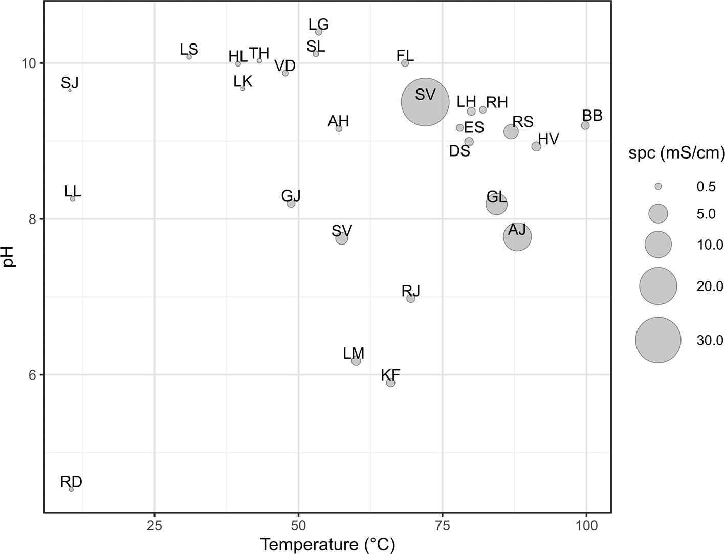
Figure 2. Graph showing the range of temperature (°C), pH, and specific conductivity (spc, mS/cm) of the sampled locations.
Site 1 - Kleifarvatn, KF230826 (63.9082429 °N, −21.9950715 °E)
The first site of this expedition is located on the Reykjanes Peninsula (
Figure 3), specifically in Lake Kleifarvatn located at 138 meters above sea level (masl), which is surrounded by volcanic features of both Holocene and Upper Pleistocene ages. These predominant features include hyaloclastites, pillow lavas, and other post-glacial lavas. To reach the site, one must leave the Krýsuvíkurvegur road and travel approximately two kilometres on an unpaved road. Upon reaching the destination point, it is necessary to park and walk towards the beach for a distance of 200 meters. The site of interest is submerged at a depth between 80 centimetres and 2 meters below the water surface and located 70 metres from the shoreline. The area of interest extends parallel to the beach for approximately 200 metres. Notably, the area exhibits two main underwater depressions from which a substantial amount of gas is emitted, along with numerous small emission points scattered all around. A faint sulphur smell can be detected in the air. A whitish encrusted mat is present in the area. The water at the emission points reaches a temperature of 66°C and has a pH of 5.9.
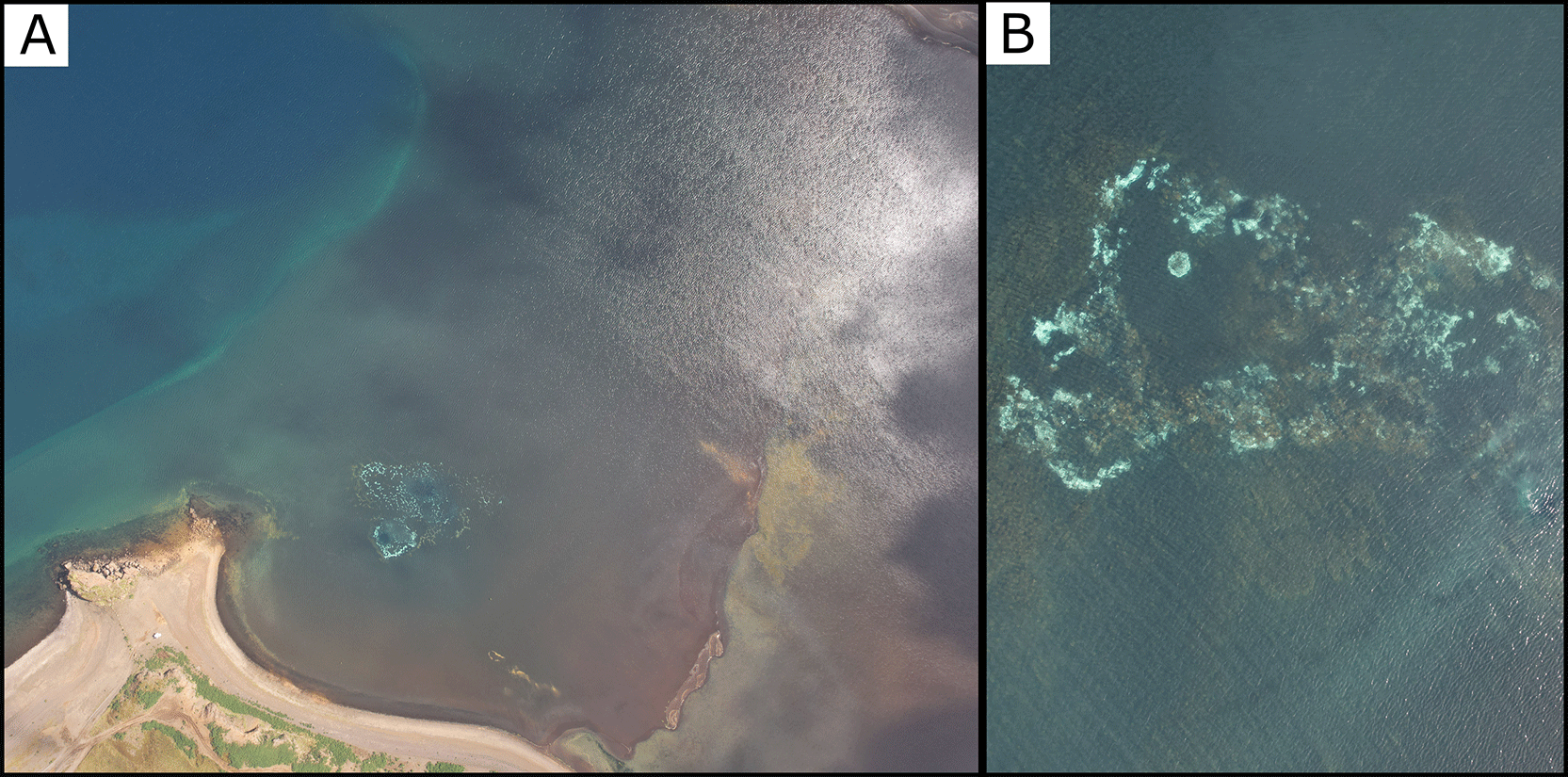
Figure 3. Aerial view (A) and close up (B) of the sampled location KF230826.
Fluids, sediments and biofilms were sampled by scuba divers. Drone and underwater photograph taken by author RP for this publication.
Site 2 - Krýsuvík, KR230828 (63.8954748 °N, −22.0570171 °E)
This site is located in the high-temperature geothermal area called Krýsuvik on the Reykjanes Peninsula (
Figure 4). Specifically, Seltún is a small area where geothermal activity is very intense located at 170 masl. The site is dotted with pools of mud, fumaroles and hot springs with temperatures reaching boiling point, and there is a moderate risk of burns. As it is a tourist site, there are well-maintained wooden walkways around the springs providing easy access. We sampled a hot spring near the boardwalk with fine suspended sediment. The main emission point measured 78°C and had an acidic pH of 2.10.
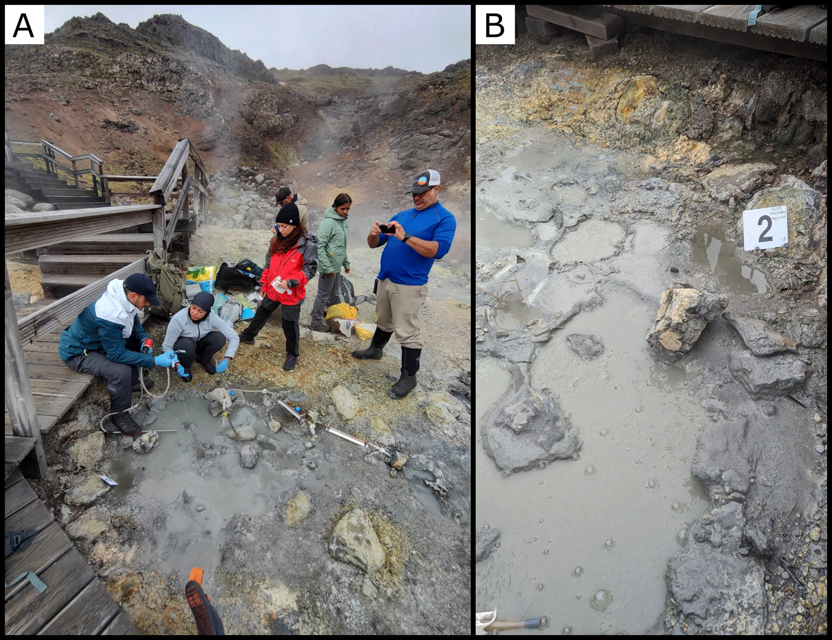
Figure 4. (A) Overview of Site 2 during sampling. (B) Ground-level view of the mud spring next to the boardwalk.
Photograph taken by author FM and DG for this publication.
Site 3 - Gunnuhver, GN230828 (63.8194083 °N, −22.6846433 °E)
The southernmost point we sampled on the Reykjanes Peninsula is the tourist site known as Gunnuhver (
Figure 5). Here, a wooden walkway for tourists facilitates access to the area. The site was characterised by pools of mud, fumaroles and hot springs with temperatures reaching boiling point located at an altitude of 17 masl. The sites of interest are a bit far from the walkways (30–40 m). We identified several mud pools approximately 20 meters from the tourist boardwalk and chose to sample the one most suitable for our purposes, without risking the safety of our team. The temperature at the emission point measured 72°C with a pH of 2.14.
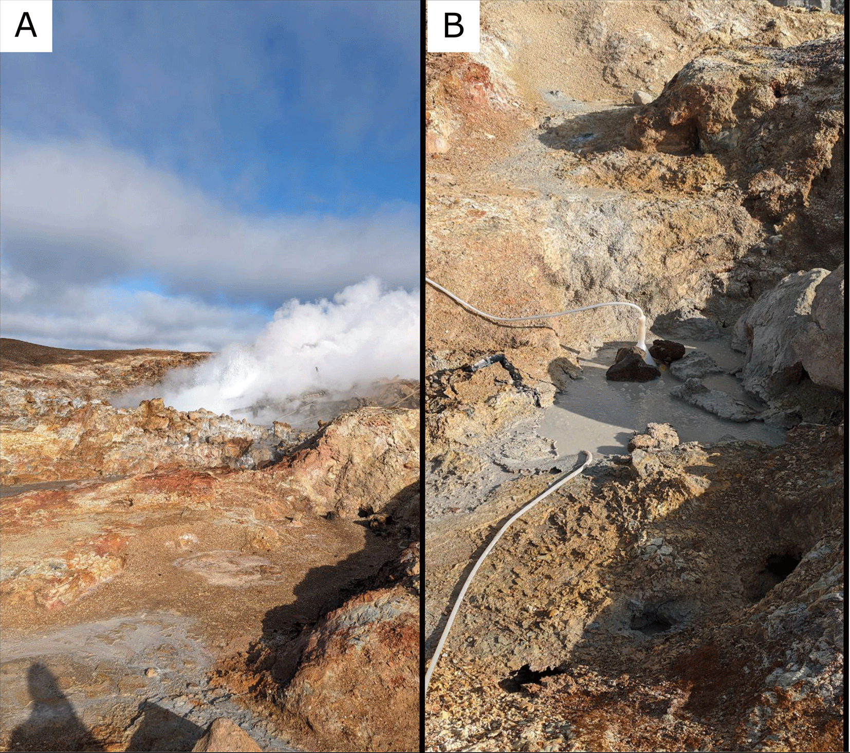
Figure 5. (A) Overview of the geothermal field with a steam plume. (B) Close-up of the selected mud pool.
Photograph taken by author FM for this publication.
Site 4 - Reykjadalur, RJ230829 (64.0289940 °N, −21.1996159 °E)
The site RJ230829 is located at an altitude of 128 masl and is situated at approximately 1 kilometer from the Parking de Reykjadalur (
Figure 6). It is situated within the Reykjadalur area, which translates to ‘Valley of Steam’ in Icelandic. Along the path to the site, there are several points of steam emission. To reach the site, one must traverse a small glacially-formed valley with a small river running through it. By following the river in a northeast direction for approximately 700 meters and then moving away from the riverbed to the north, one arrives at Site 4 of this expedition. The soil in this area is rich in water content, and at the emission points, pools are formed where temperature measurements have recorded a maximum of 69.5°C with a pH of 6.98 and a flow rate of 0.15 L/s. This is evident in the substantial presence of vegetation, including a grassy covering, and microfauna such as insects and birds. Furthermore, grazing animals are allowed to pasture near the river.
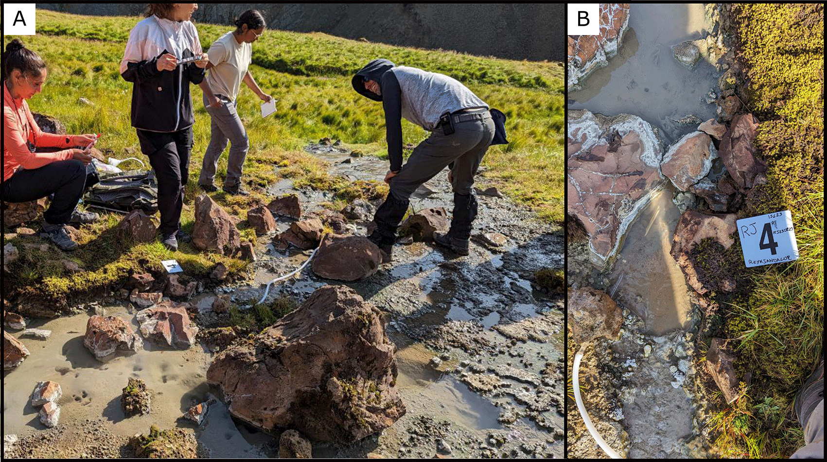
Figure 6.
(A) Overview of Site 4 with a muddy geothermal pool during sampling. (B) Close-up of the sampled pool with silicone and titanium tube to recover the fluids.
Photograph taken by author FM for this publication.
Site 5 Laugarás, LH230829 (64.1129167 °N, −20.4958392 °E)
The Laugarás site is easily accessible, situated near the Hvítá River (
Figure 7). We departed from the main road, Skálholtsvegur, and continued for an additional 200 meters by vehicle. From there, it is only a short walk of a few minutes to reach this grass plain rich in gas emissions (Figure A) at an altitude of 59 masl. It stretches for approximately 1 kilometer in length and it is about 100 meters wide. Walking from north to south while keeping to the left for 400 meters, one arrives at an artificial pool measuring 1x1.5 meters (Figure C). From this structure, there is a hot emission with a temperature of 80°C, pH of 9.38 and a flow rate of 17.4 L/s. Surrounding this site, there are additional points of fluid and gas emissions.
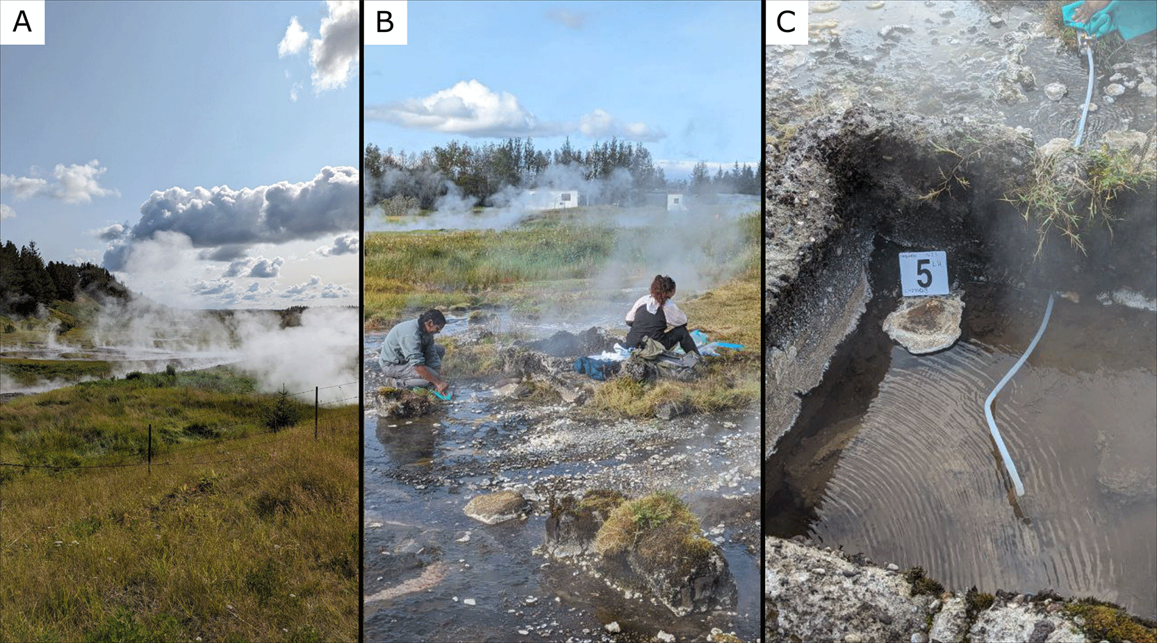
Figure 7.
(A) Large view of the area of the sampling site. (B) We sampled an artificial pool measuring 1x1.5 meters (C) Detail of the sampling location where the fluids were collected.
Photograph taken by author FM for this publication.
Site 6 Landmannalaugar, LM230830 (63.9915483 °N, −19.0627467 °E)
The Fjallabak Nature Reserve represents the location of the sixth site (https://nat.is/fjallabak-nature-reserve/) (
Figure 8). The area is not particularly hazardous, as evidenced by the presence of numerous tourists in the pools. In close proximity to the site, there are several hot springs with temperatures ranging between 40 and 60 degrees Celsius. Our emission point is at an altitude of 597 masl and located approximately 200 meters south of the bathing area frequented by tourists. The spring measured approximately 60°C and had a pH level of 6.18. A few meters away, measurements were taken for both water flow (406 L/s) and gas emissions (605 L/s). The site featured a multilayered microbial mat of various colors.
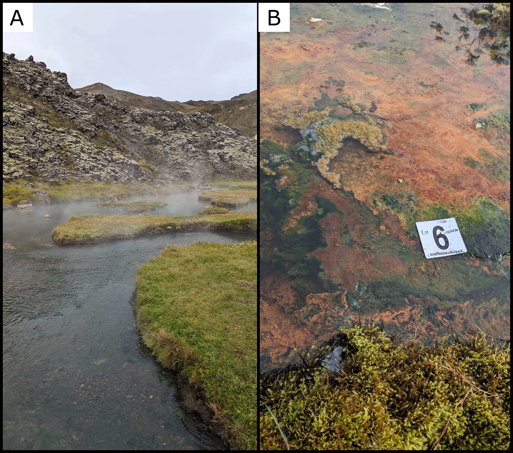
Figure 8. (A) An overview of the site (B) Microbial mats at the sampling site showing orange and green coloration.
Photograph taken by author FM for this publication.
Site 7 Seljavallalaug, SV230831 (63.5661483 °N, −19.6079383 °E)
Seljavallalaug is a protected outdoor pool in southern Iceland located at an altitude of 76 masl, fed by a natural hot spring (
Figure 9). We moved from the main road and traversed 4 kilometers within one of the glacial valleys that characterize the area. Inside the valley, there is a river that flows right by the pool. The main spring inlet was located right above the pool on top of a carbonate structure, which had a water flow of 0.24 L/s and a multicolored mucilaginous microbial mat. The water temperature measured 57.5°C with a pH of 7.75.
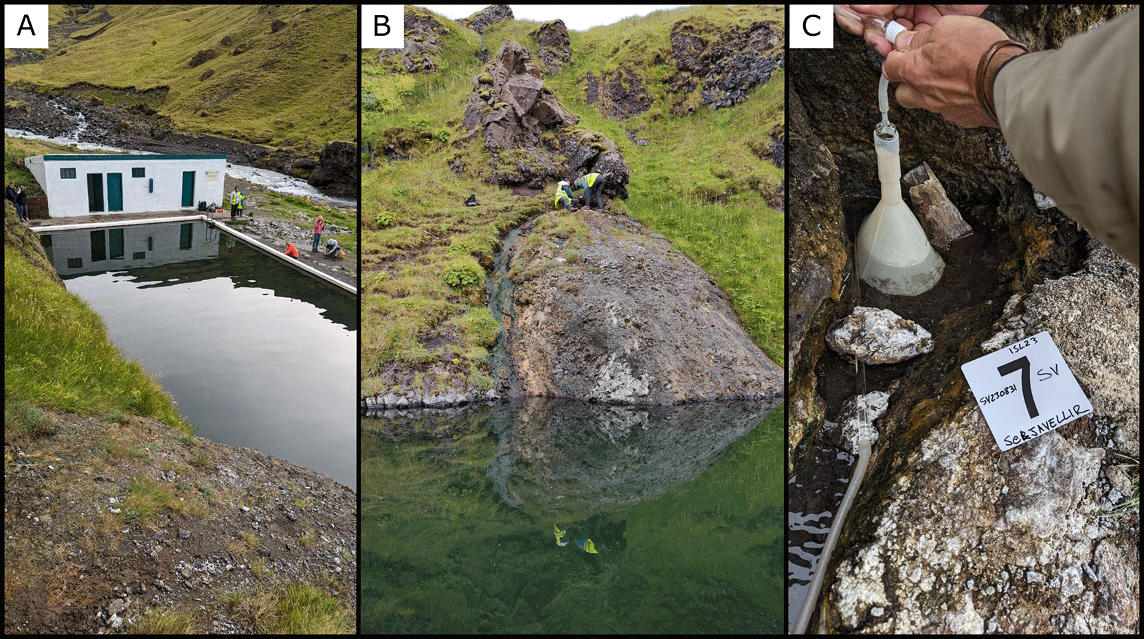
Figure 9.
(A) Seljavallalaug pool is 10 meters (30 feet) in width and 25 meters (82 feet) in length. (B) The emission point that we sampled was above the pool on top of a carbonate structure. (C) Close up of the emission point.
Site 8 Hvammsvík, HS230901 (64.3742033 °N, −21.5658497 °E)
This site is an artificial well utilized for heating nearby buildings of a geothermal bathing facility (https://guidetoiceland.is/travel-iceland/drive/hvammsvik-hot-springs) (
Figure 10). It is located at an altitude of 25 masl on a side of the fjord Hvalfjörður on the western side of Iceland. Along its coast, situated 200 meters from the sea there is the site HS230901. We connected our silicone tube with connectors to the well, and we collected our water sample. No sediment samples were collected for this site. The water from this well had a flow rate of 16.75 L/s, a temperature of 91.3°C, and a pH of 8.93.
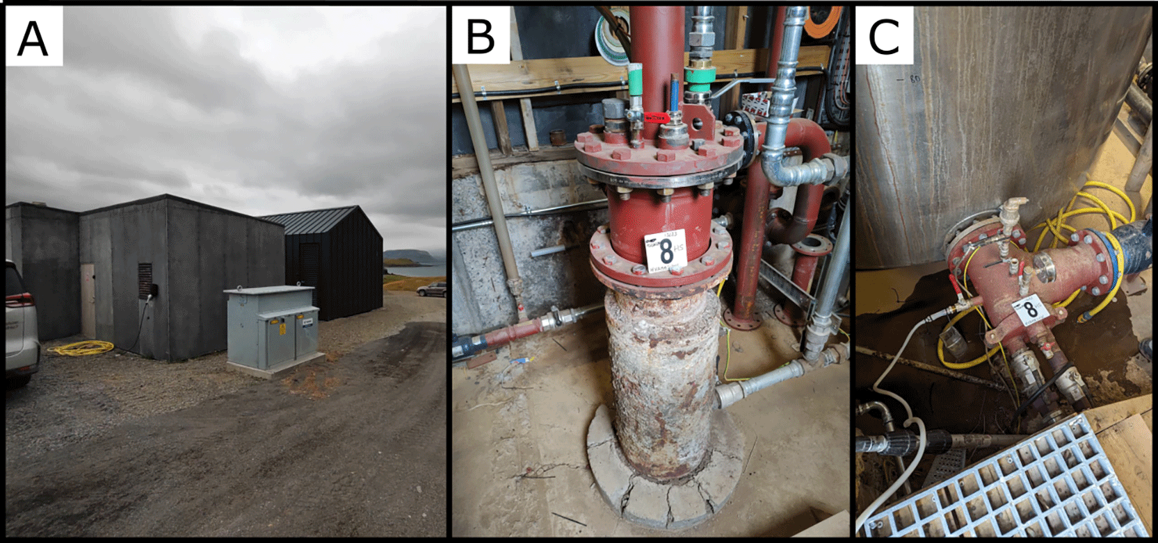
Figure 10. (A) An overview of the site (B) The artificial well used for heating nearby buildings (C) A closeup of the emission point sampled.
Photograph taken by author FM and DG for this publication.
Site 9 Englandshverir, ES230901 (64.4905648 °N, −21.179099 °E)
This site was located at an altitude of 178 masl and approximately 240 meters from the structure that we used as a bridge at the coordinates 64.492778 °N, −21.176364 °E, along a small river (
Figure 11). We sampled one of the emission points, which had a temperature of 78°C and a pH of 9.17. The water flow of the river near the emission point was 7 L/s, and the area was rich in this reddish-orange mucilaginous microbial mat.
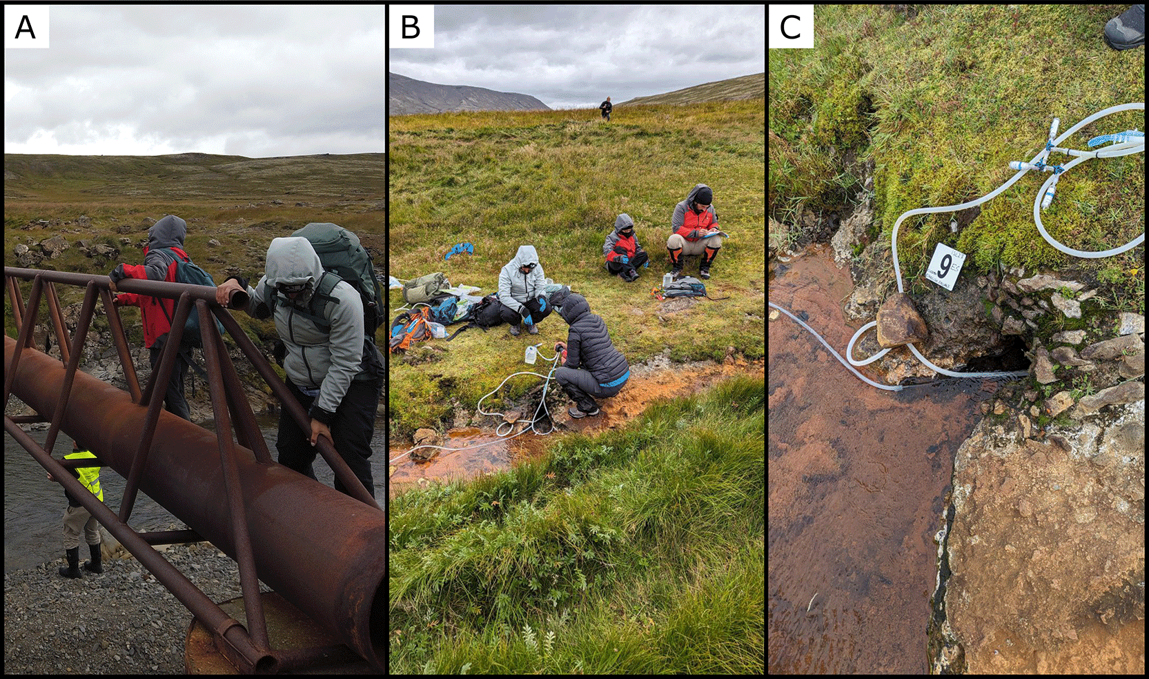
Figure 11. (A) The structure used as a bridge to cross the river (B) An overview of the site (C) A closeup of the emission point, we used a titanium tube to go how deep it was possible.
Photograph taken by author FM and JP for this publication.
Site 10 Árhver, AH230901 (64.6584216 °N,-21.3639612 °E)
Árhver is a spring located in the middle of a river (a tributary of the Hvítá River) at an altitude of 29 masl (
Figure 12). The car can be parked 50 meters away from the spring, and it can be reached by crossing sand bars and shallow water areas. The spring consists of a large emission point with water temperatures around 100°C and significant gas discharge. Additionally, both near the main crater and along the river, there are several smaller emission points where hot water emerges at varying temperatures. To avoid being struck by sudden jets of boiling water, we chose not to work on the main crater and instead moved a few meters away to one of the smaller emission points. The water temperature at this location was 57°C, and the pH was 9.16.
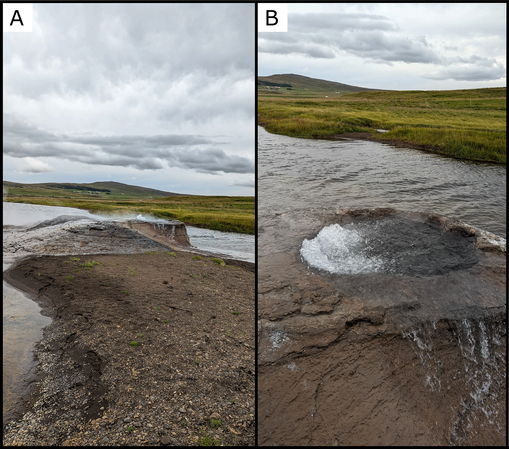
Figure 12. (A) Overview of the geothermal mound emerging from the riverbed. (B) Close-up view of the boiling vent opening.
Photograph taken by author FM for this publication.
Site 11 Borgarbyggð, BB230902 (64.6883977 °N, −21.4028918 °E)
This site is located on private property at an altitude of 41 masl and 450 meters from the Hvítá River (
Figure 13). A few meters from an old building (Figure A), there was an emission point of water and gas at an altitude of 41 masl. The water had a temperature of 99.8°C with a pH of 9.20. The area was water-rich, and there were multiple emission points. We selected a point with a flow rate of 18 L/s.
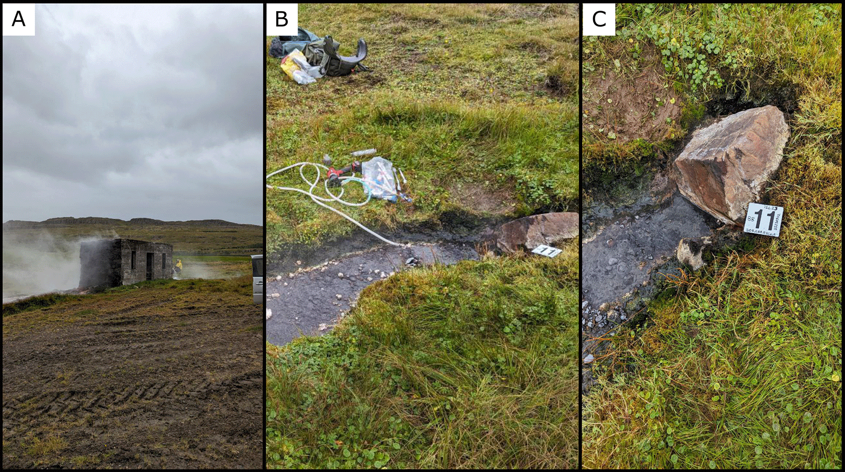
Figure 13. (A) An old building on private property close to the site. (B) An overview of the sampled site (C) A closeup of the emission point sampled.
Photograph taken by author FM for this publication.
Site 12 Rauðamelsölkelda, RD230902 (64.8956115 °N, −22.3388239 °E)
Rauðamelsölkelda is a spring located at an altitude of 107 meters asl. After crossing a small bridge, we found the spring among the rocks in a pool approximately 1 x 2 meters in size (
Figure 14). The water temperature was 10.5°C and pH 4.53, and there were gas emissions with a flow rate of 3.5 L/s.
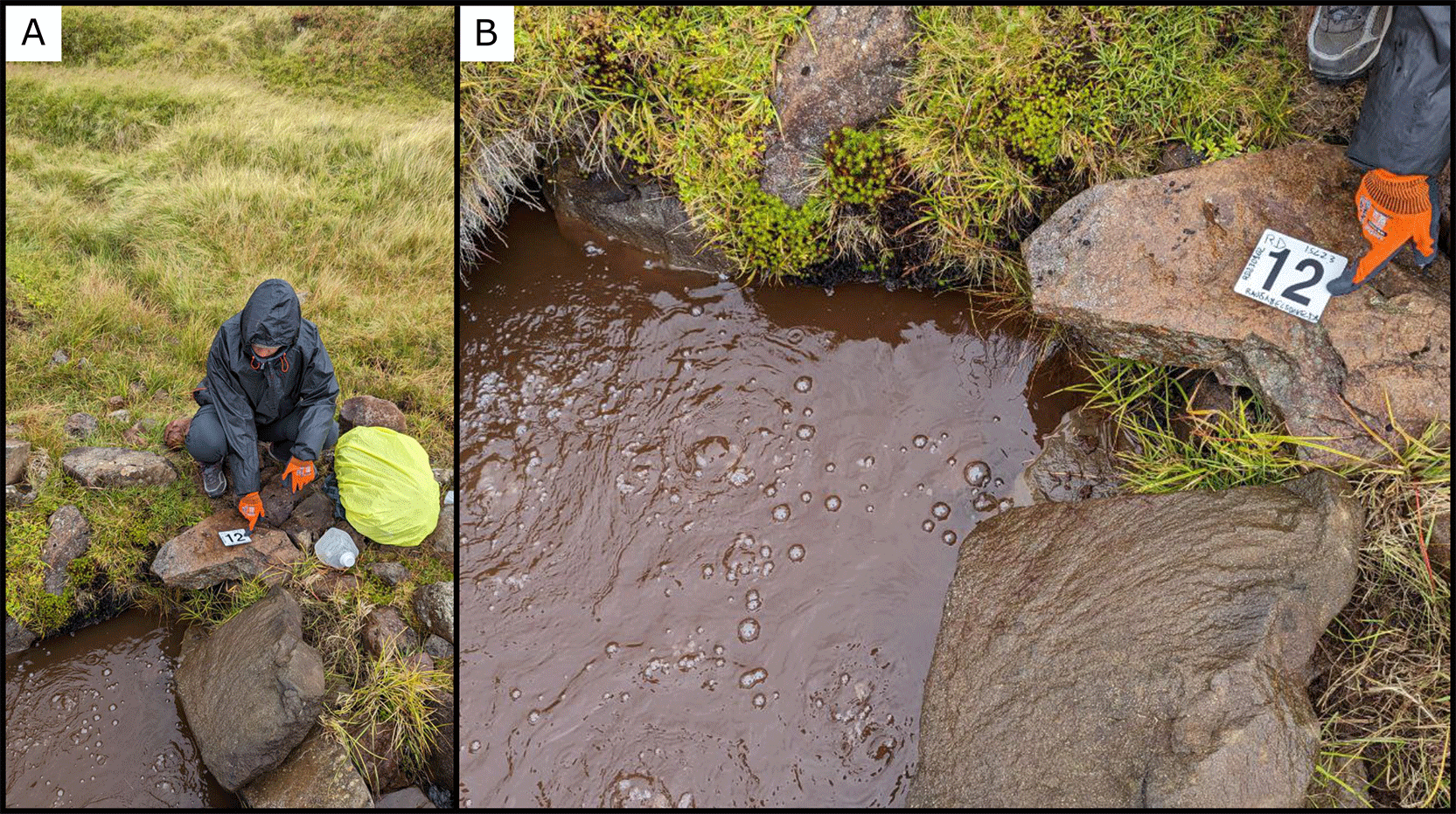
Figure 14. (A) Overview of the sampling activity at the spring of Rauðamelsölkelda. (B) Close-up view of the bubbling pool where water was collected.
Photograph taken by author FM for this publication.
Site 13 Reykjaskóli, RS230903 (65.2577603 °N, −21.1004580 °E)
The site RS230903 is located at an altitude of 19 masl in an area with water-rich soil, near the Barnaskólavegur towards Reykir road, close to some houses at an altitude of 19 masl (
Figure 15). There is a concrete pool measuring 2 x 3 meters, with gas emissions at multiple points, and a water temperature of 86.9°C and the pH was 8.12. The water flow rate was 5 L/s. We sampled the water and the sediment at the bottom of the pool.
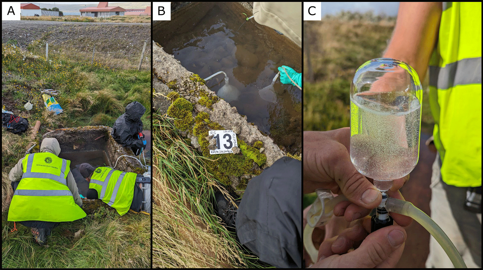
Figure 15. (A) Overview of the artificial basin used for water sampling. (B) Close-up view of the tubing system and collection setup. (C) Water sample collected in a giggenbach bottle for gas analysis.
Photograph taken by author FM for this publication.
Site 14 Reykhólar, RH230904 (65.4456505 °N, −22.2064709 °E)
In the fjord area in the northwest of Iceland, there is a small village named Reykhólar, which is 12 meters above sea level (
Figure 16). Here, we found a hot water spring on the property of a local resident. The spring consisted of a series of small outlets emerging on the side of a small creek running through the property. The sampled outlet had a fluid temperature of 82°C with a pH of 9.4 and was surrounded by bright green and orange microbial mats and precipitated calcite. Free gas was sampled a few meters away from the point where we sampled the fluids.
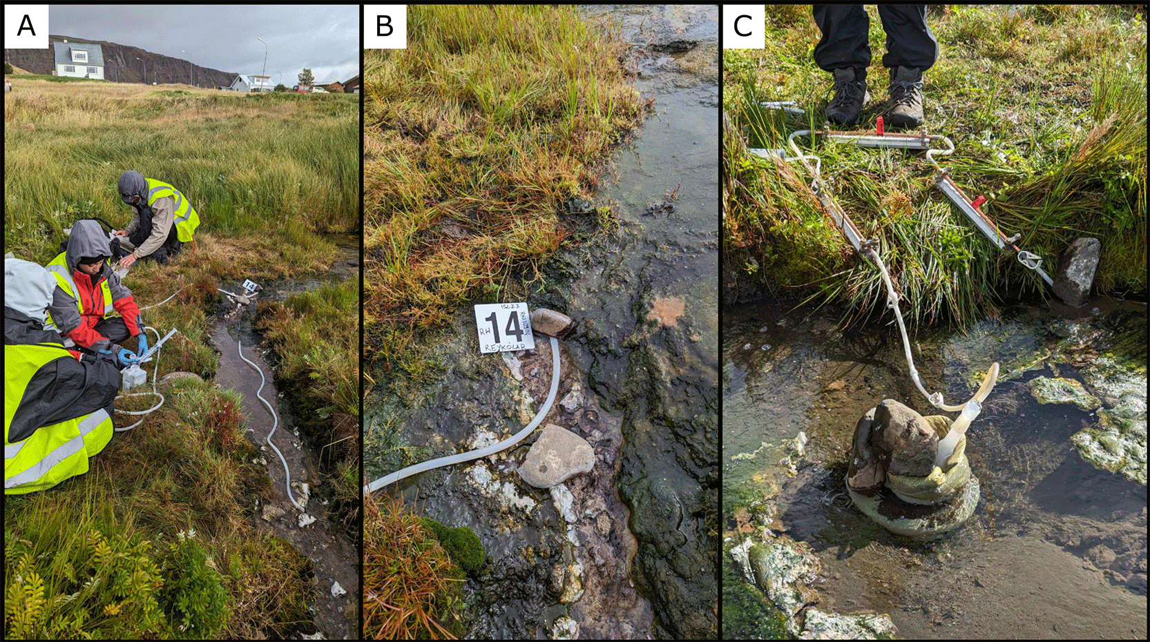
Figure 16. (A) Collecting water samples using silicon tubes, syringes, and a peristaltic pump. (B) and (C) Close-up views of the small geothermal stream and the tubing system used for water collection.
Photograph taken by author FM for this publication.
Site 15 Drangsnesvegur, DS230904 (65.698493 °N, −21.559922 °E)
At 2 meters above sea level, near Drangsnesvegur road, we sampled our fifteenth site. This location was historically utilized by humans, as evidenced by the small artificial pool (Figure A) just above the sea (
Figure 17). Along the coast near the pool, there are several points where high-temperature water emerges. The point we sampled (Figure B) had a temperature of 79.6°C, a pH of 8.99, and a flow rate of 2.1 L/s. The site was characterised by very large and thick multicoloured microbial mats. Photograph taken by author FM for this publication.
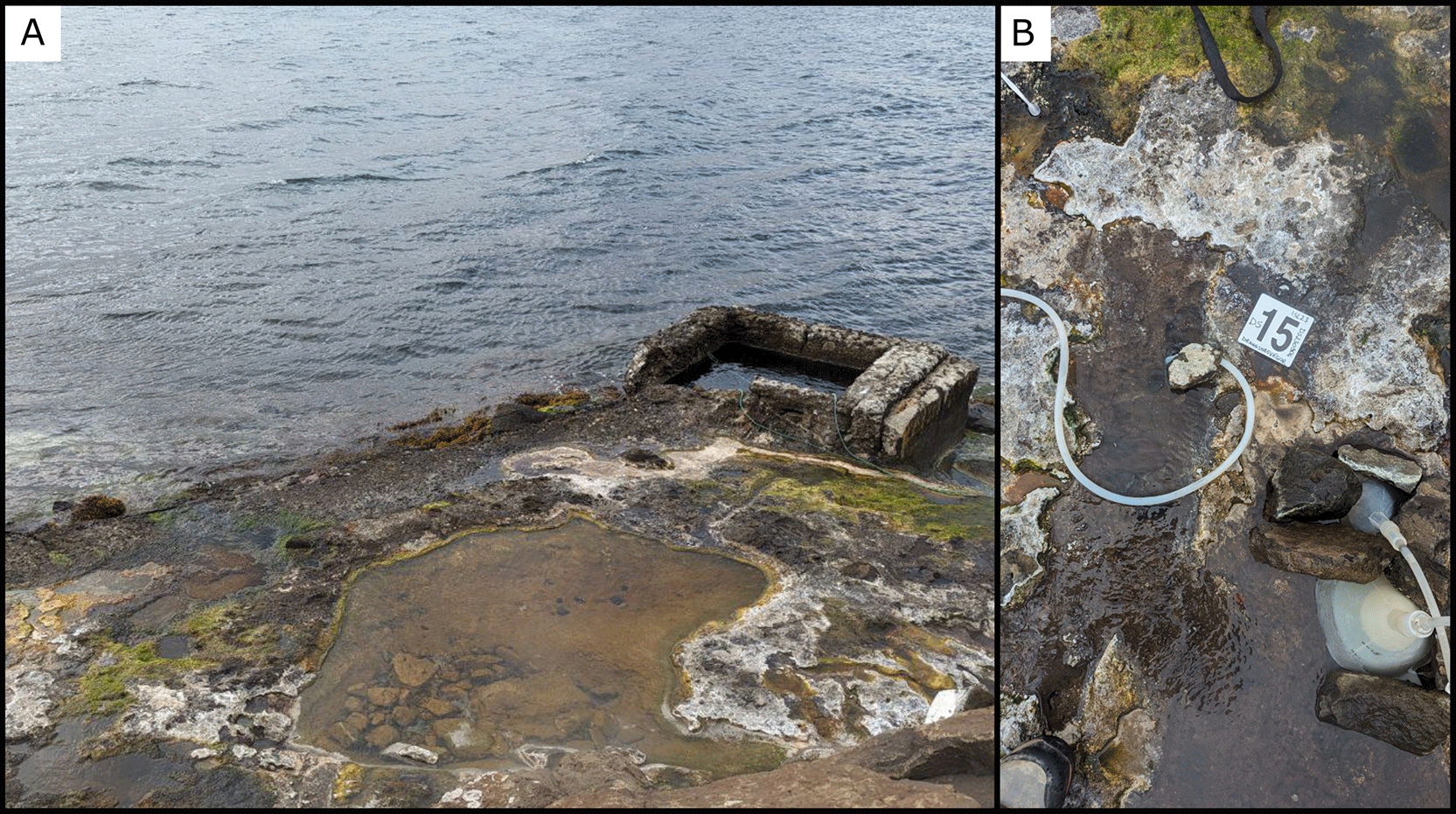
Figure 17. (A) Overview of the coastal geothermal pool adjacent to the shoreline. B) Close-up view of the sampling setup used to collect water from the outflow area.
Site 16 Hellulaug, HL230905 (65.5776628 °N, −23.1597213 °E)
Hellulaug is located in the northwest region of Iceland, a natural hot spring pool near the village of Flókalundur (
Figure 18). The pool is located in one of the fjords of the area and is measuring approximately 4 x 3 meters, and about 20 to 30 inches deep. The site has an altitude of 5 masl, just a few meters from the sea. The water temperature is 39.5°C, and the pH is 9.99. At the point where the water flows from the pool to the sea, we measured a flow rate of 4.8 L/s.
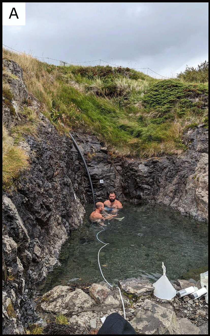
Figure 18. (A) Overview of the small geothermal pool where water was collected through tubing connected to the lateral outflow.
Photograph taken by author FM for this publication.
Site 17 Gamla Laugin Reykjanes, GL230905 (65.9290867 °N, −22.4287850 °E)
The site GL230905 is located at an altitude of 6 masl and in the inner part of the Ísafjarðardjúp fjord in northwestern Iceland (
Figure 19). Its accessibility depends on the tidal cycle. When the water recedes, it leaves exposed pools and marine vegetation, and there are several fractures from which high-temperature water emerges (Figure A). Our site is situated among the rocks just a few meters from the sea (6 meters above sea level). In our case, we sampled an emission point with a temperature of 84.4°C and a pH of 8.19.
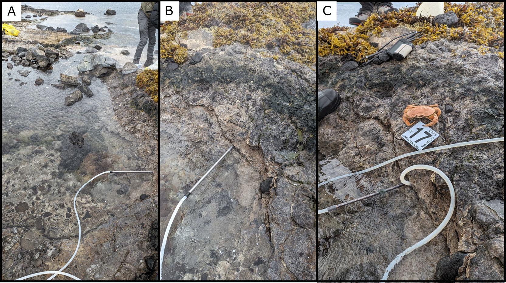
Figure 19. (A) Overview of the coastal sampling area. (B) and (C) Close-up views showing the tubing system used to collect water directly from the outflow cracks.
Photograph taken by author FM for this publication.
Site 18 Fosslaug, FL230906, (65.4941967 °N, −19.3836483 °E)
This site is located in northern Iceland at an altitude of 49 masl, near the Húseyjarkvísl River (
Figure 20 A) at the Reykjafoss waterfall. There is easy parking near the site. The waterfall is a tourist site, easy to access. Just before the waterfall, there is the Fosslaug spring (
Figure 20 B), which flows into a pool along the river. The spring had intermittent gas emission with an average period of 2.45 minutes, fluid temperature of 68.5°C and pH 10.
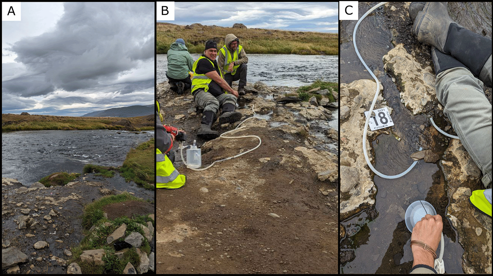
Figure 20. (A) Overview of the river system where sampling was conducted. (B) and (C) Close-up views of the field setup and tubing used for water collection.
Photograph taken by author FM for this publication.
Site 19 Strýtan vent, SV230907 (65.828852 °N, −18.111779 °E)
In northern Iceland, not far from the country’s second-largest town, Akureyri, there is a unique dive site: Strýtan (
Figure 21). Situated in the middle of Eyjafjörður at a depth of around 70 meters, this site has been venting warm water into the ocean for approximately 11,000 years. When the mineral-rich freshwater mixes with the cold seawater, the dissolved minerals precipitate, gradually forming a towering silica chimney. Over millennia, this process has built a structure that rises 55 meters from the seafloor, reaching to within 15 meters of the surface. Thanks to the Strytan Dive Center (Strytan Divecenter), we reached the site by Zodiac boat and collected data, including the water temperature from one of the vents, which was 72°C, and the pH was 9.5.
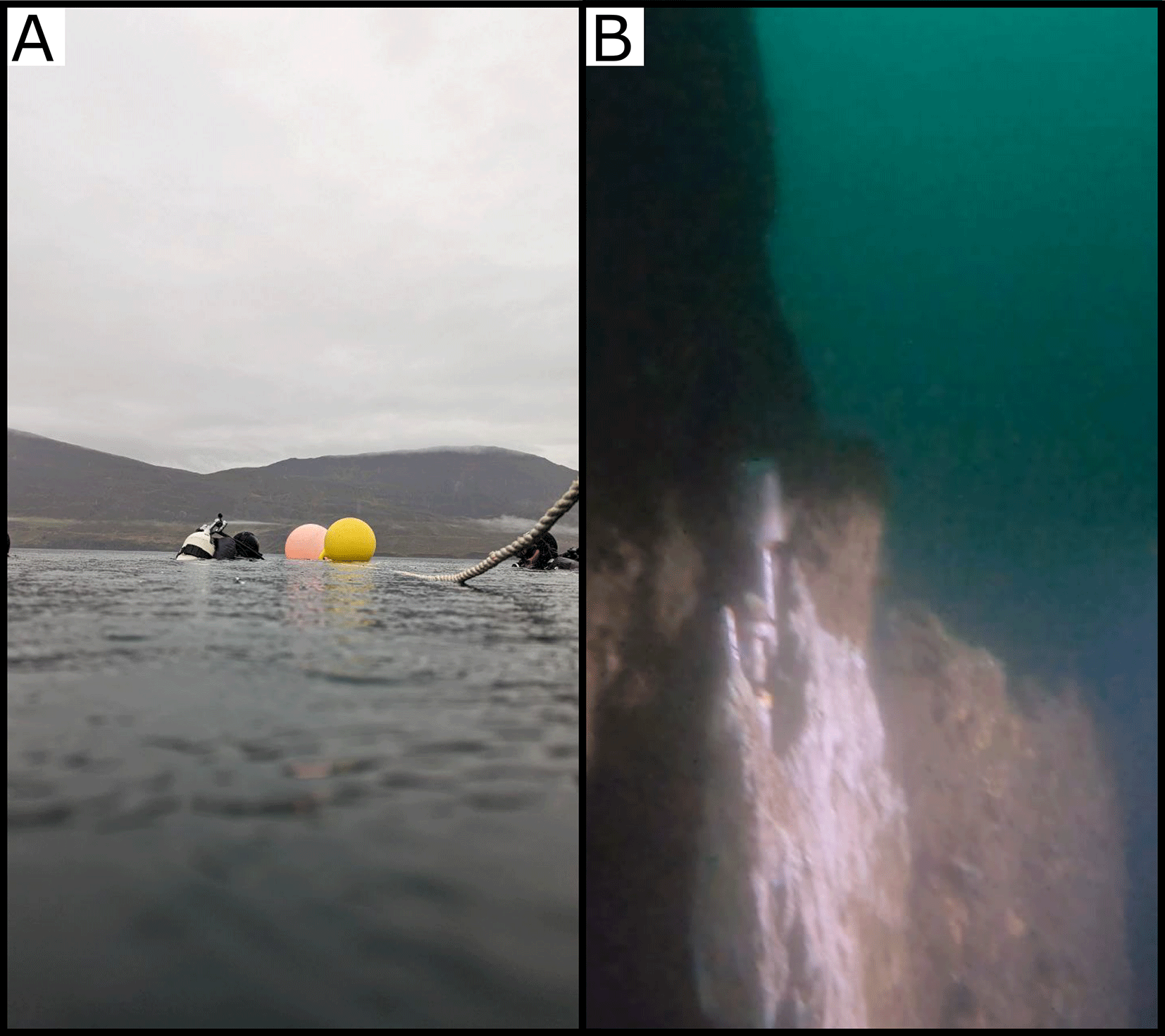
Figure 21. (A) Overview of the diving operation conducted at the hydrothermal field, showing the sampling area marked by buoys. (B) A close-up of one of the venting sites at Strýtan.
Photograph taken by author FM and DG for this publication.
Site 20 Laugar, LG230907 (65.7225747 °N, −17.3505889 °E)
In the Laugar area of North Iceland lies site LG230907 within a private residence, surrounded by vegetation at an altitude of 163 masl, there is a well covered by a metal plate (
Figure 22). It is located on a small hill, unstable and slippery due to water and vegetation. After lifting the metal plate, we measured the water temperature (53.5°C) as close as possible to the source. The pH was 10.4 and the water flow rate was 0.4 L/s.
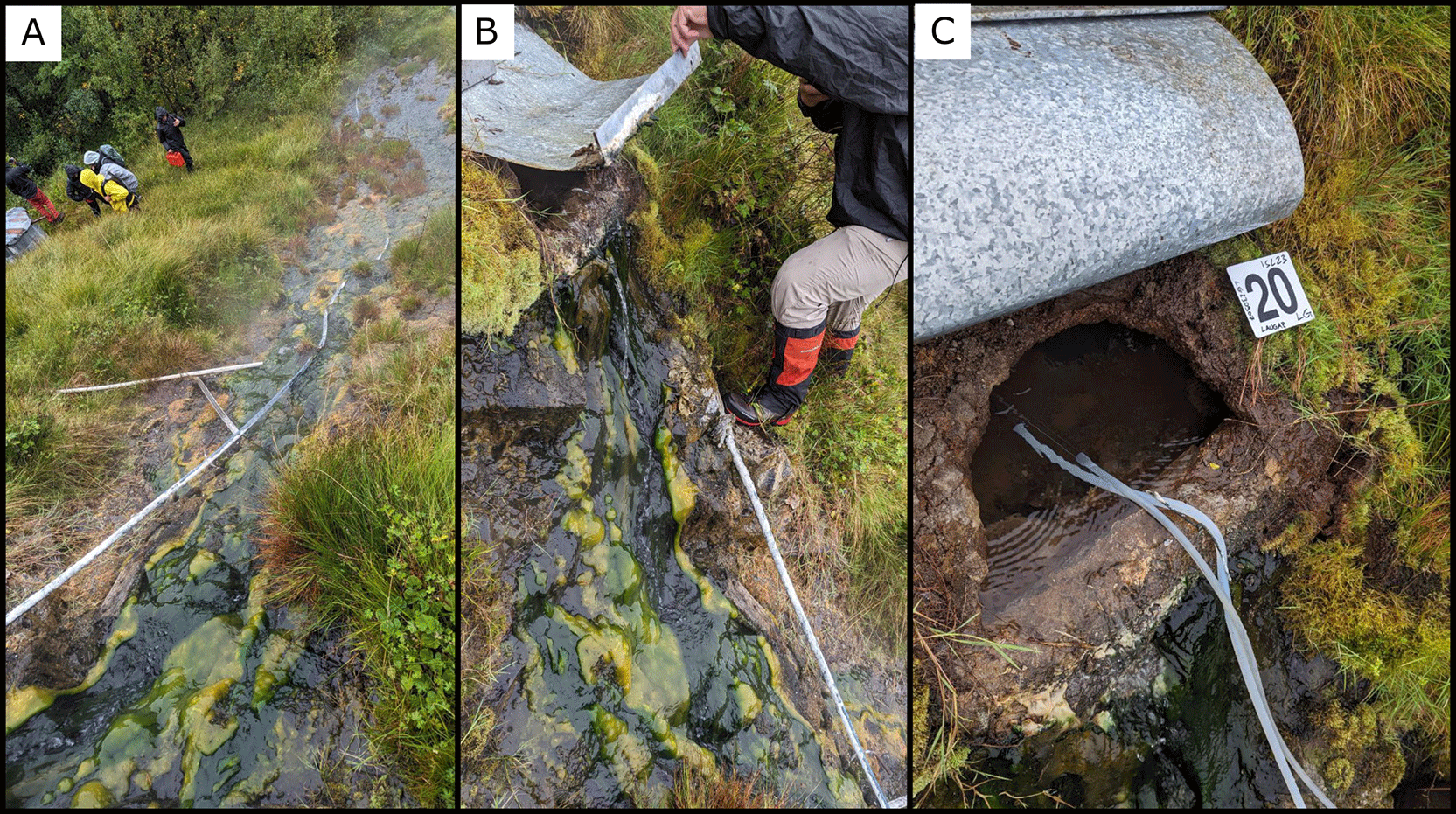
Figure 22. (A) Overview of the geothermal outflow covered by microbial mats. (B) and (C) Close-up views of the water collection setup near the outlet pipe.
Photograph taken by author FM for this publication.
Site 21 Lón Lake, LL230908 (66.1020433 °N, −16.9077000 °E)
In the northern part of the island at an altitude of 5 masl, 3 km from the Arctic Ocean, there is Lake Lón (
Figure 23). Near a fish farm, just a few meters from one of the lake’s shores, there is the site LL230908. The water temperature was low, 10.77°C and pH 8.26.
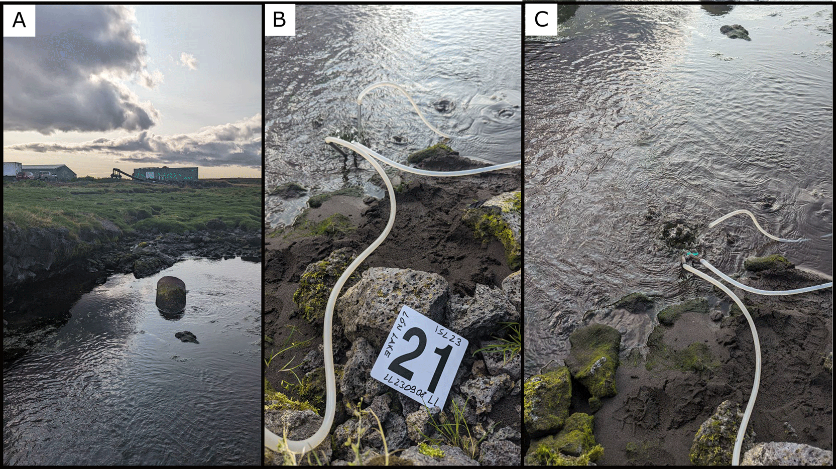
Figure 23. (A) Overview of the pond where sampling was conducted. (B) and (C) Close-up views of the tubing system used for water collection from the outflow area.
Photograph taken by author FM for this publication.
Site 22 Mývatn Námaskarð Hverir, MH230908 (65.6415088 °N, −16.8090939 °E)
The twenty-second site is located in the tourist area of Námaskarð Hverir, near Lake Mývatn at an altitude of 369 masl (
Figure 24). In this area there are many mud pools, some reaching boiling temperature. There are also several gas emission points. In one of these pools, we collected samples for geochemical analysis, and the temperature was 98.4°C. We collected microbiological samples within this same pool, and at the place where we collected the samples we measured a temperature of 84°C. In the same area, we also sampled a fumarole with a temperature of 137°C.
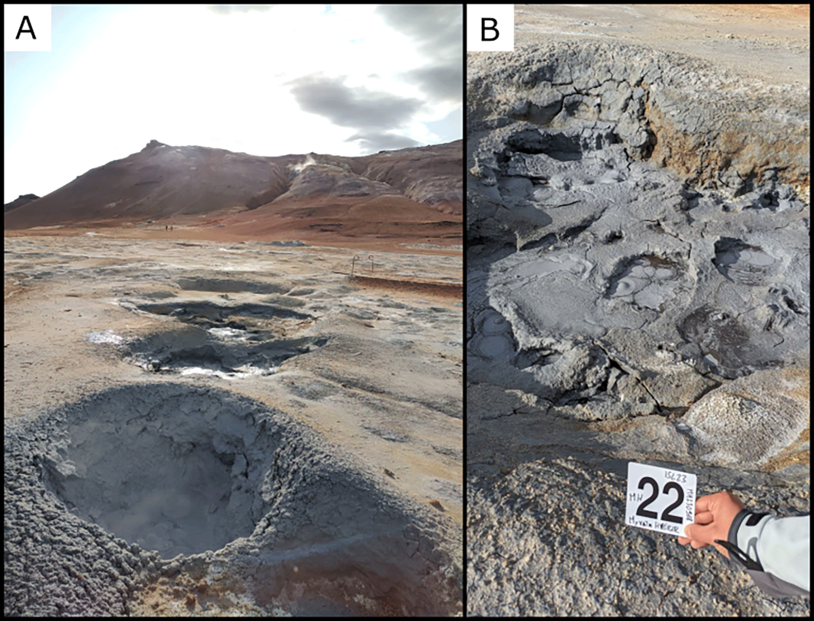
Figure 24. (A) Overview of the mud pool sampled, showing active geothermal activity and gas bubbling.
Photograph taken by author FM for this publication.
Site 23 Selárdalslaug, SL230909 (65.8023317 °N, −14.9095317 °E)
Along the Selá River, which flows into the Arctic Ocean in eastern Iceland, there is at an altitude of 63 masl, the site SL230909 (
Figure 25). This site is a well with unknown depth, utilized by a public pool called Selárdalslaug. The well is located at a higher point than the pool, and unfortunately, the well’s structure only allowed us to sample water at a temperature of 53°C and pH 10.12, while we sampled sediments further downstream near a pipe discharging water close to the river. The water flow near the well was 4 L/s.
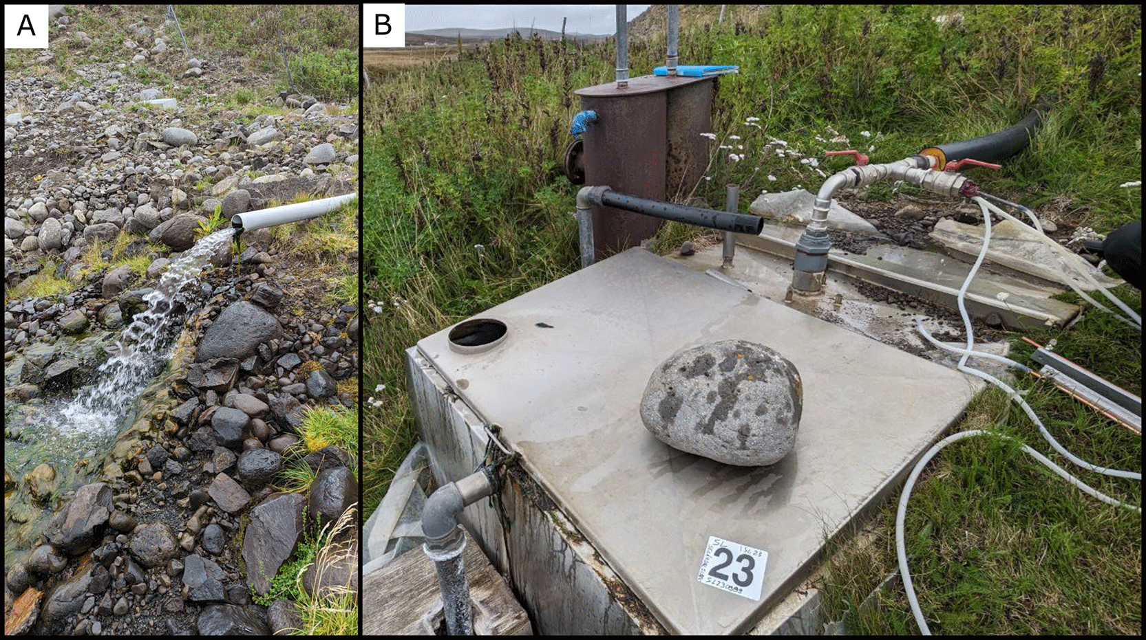
Figure 25. (A) Overview of the artificial outlet discharging geothermal water. (B) Close-up view of the sampling setup connected to the outlet tube.
Photograph taken by author FM for this publication.
Site 24 Ærlækjarsel, AJ230909 (66.1652014 °N, −16.5584453 °E)
The site AJ230909 is located on private property in northern Iceland, at an altitude of 6 masl, 1 km from the Arctic Ocean and 2 km from the owner’s residence (
Figure 26). The terrain in this area was rich in water. Near a shed we found a spring at 88°C and pH 7.87 with little gas flow. Near the spring there was a thin, filamentous brown microbial mat.
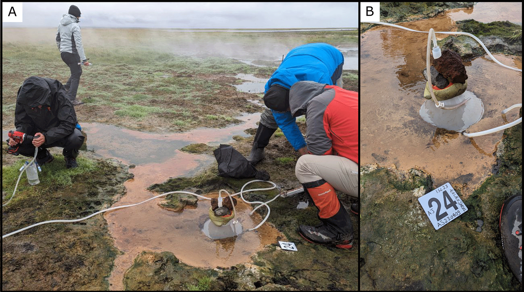
Figure 26. (A) Overview of the sampling activity, showing the geothermal outflow area. (B) Close-up view of the funnel used for sampling at the emission point.
Photograph taken by author FM for this publication.
Site 25 Grjótagjá, GJ230910 (65.6264991 °N, −16.8828010 °E)
Grjótagjá is a small lava cave located at an altitude of 302 masl in northern Iceland, near Lake Mývatn (
Figure 27). Inside, it hides a hot spring that, for many years, was a popular natural bathing spot among Icelanders. Entering from the right entrance and keeping to the right while following the perimeter of the pool, near the surface, you can observe a flow of hot water at 48.7°C. The measured pH was 8.20.
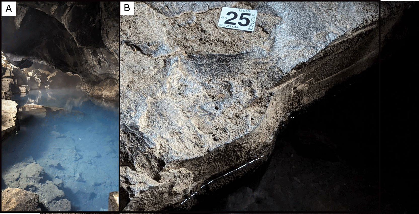
Figure 27. (A) Overview of the cave pool selected for water sampling. (B) Close-up view of the emission point.
Photograph taken by author FM for this publication.
Site 26 Vaðlaheiðargöng, VD230911 (65.6942367 °N, −18.0543738 °E)
At an altitude of 72 masl, in the Eyjafjörður fjord on the shore opposite to Akureyri, 50 meters east of the road, there are three pipes with hot water emerging from a friable soil (
Figure 28). Of the three pipes, we sampled the central one with a PP bottle because the flow of the water was too strong for our tube. The water temperature was 47.7°C, and the pH was 9.87.
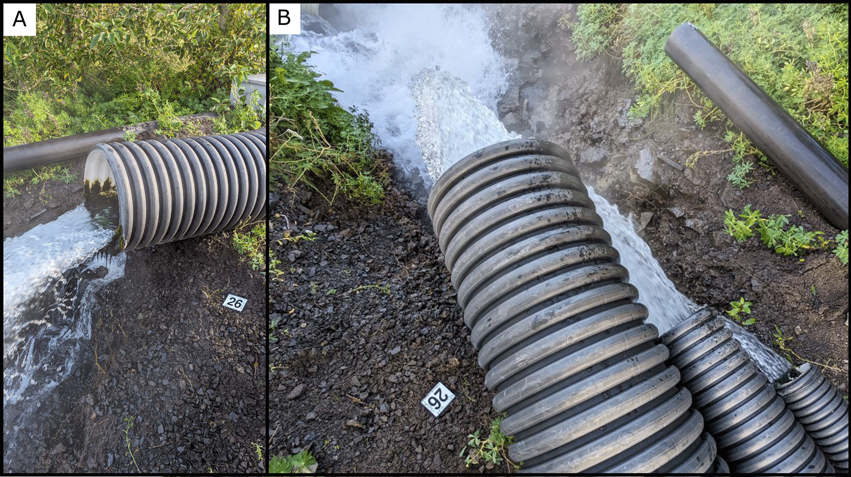
Figure 28. (A) Overview of the artificial tube selected for water sampling. (B) Close-up view of the emission point.
Photograph taken by author FM for this publication.
Site 27 Laugafell South, LS230912 (64.9271304 °N, −18.2822520 °E)
For the last four sites we move to the center of the island, specifically between two large glaciers, Hofsjökull and Vatnajökull (
Figure 29). At an altitude of 765 masl, in an area that the locals call Laugafell South, is our twenty-seventh site. We sampled a spring marked by a pile of rocks, with no gas emissions. Here the water temperature was 31°C and a pH was 10.08.
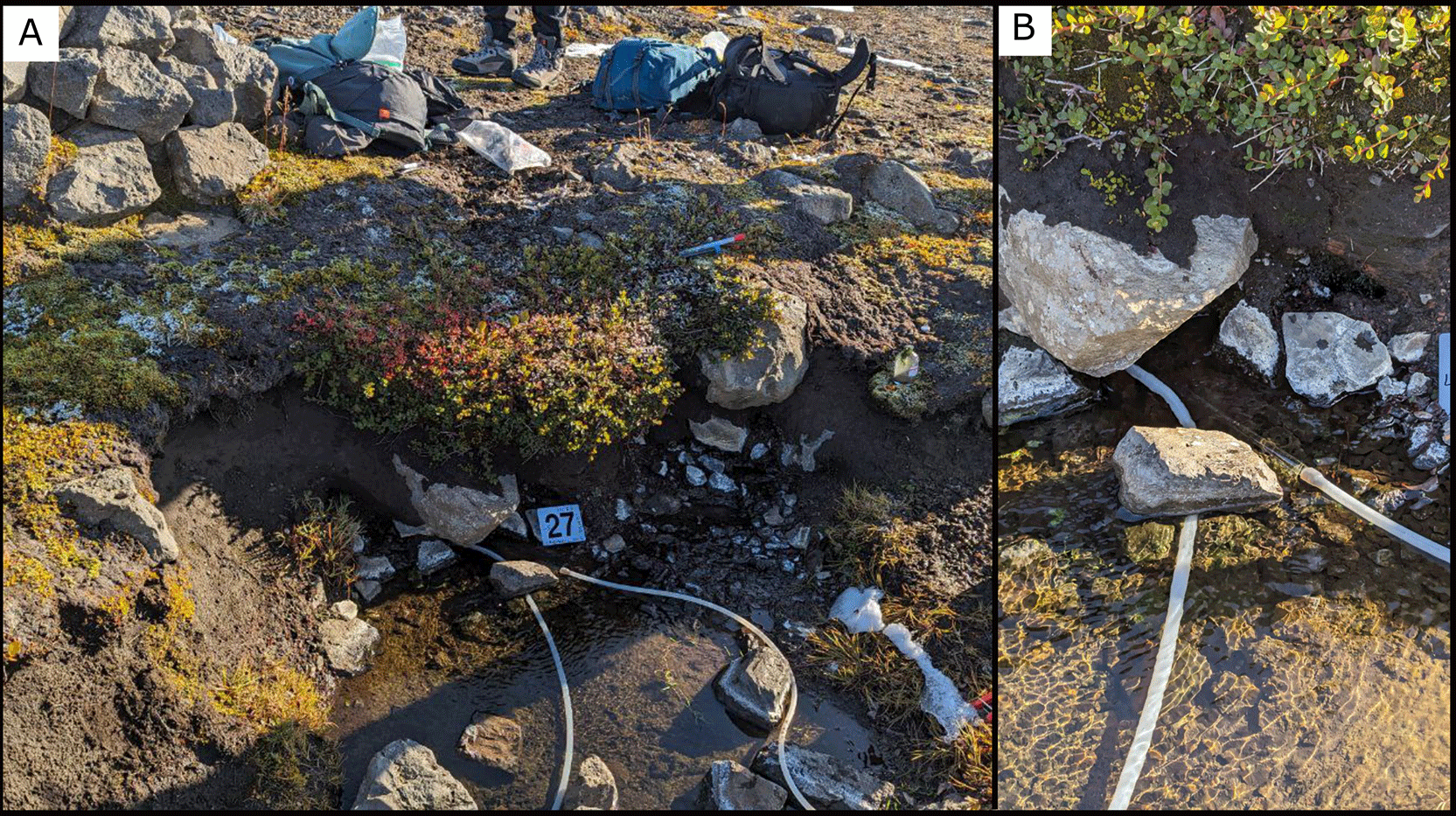
Figure 29. (A) An overview of the site chosen for the sampling. (B) Close-up view of the emission point.
Photograph taken by author FM for this publication.
Site 28 Þuríðarhver, Thuridahver, TH230912 (65.0302351 °N, −18.3305599 °E)
TH230912 is the twenty-eighth site of this expedition, and is located at an altitude of 757 masl and at 250 meters from Icelandic university cabins, northwest direction (
Figure 30). Between two small hills there is a pool filled with algae, and with a small flux of gas that we accumulated in a flannel and then sampled. The water temperature was at 43.2°C and a pH of 10.03.
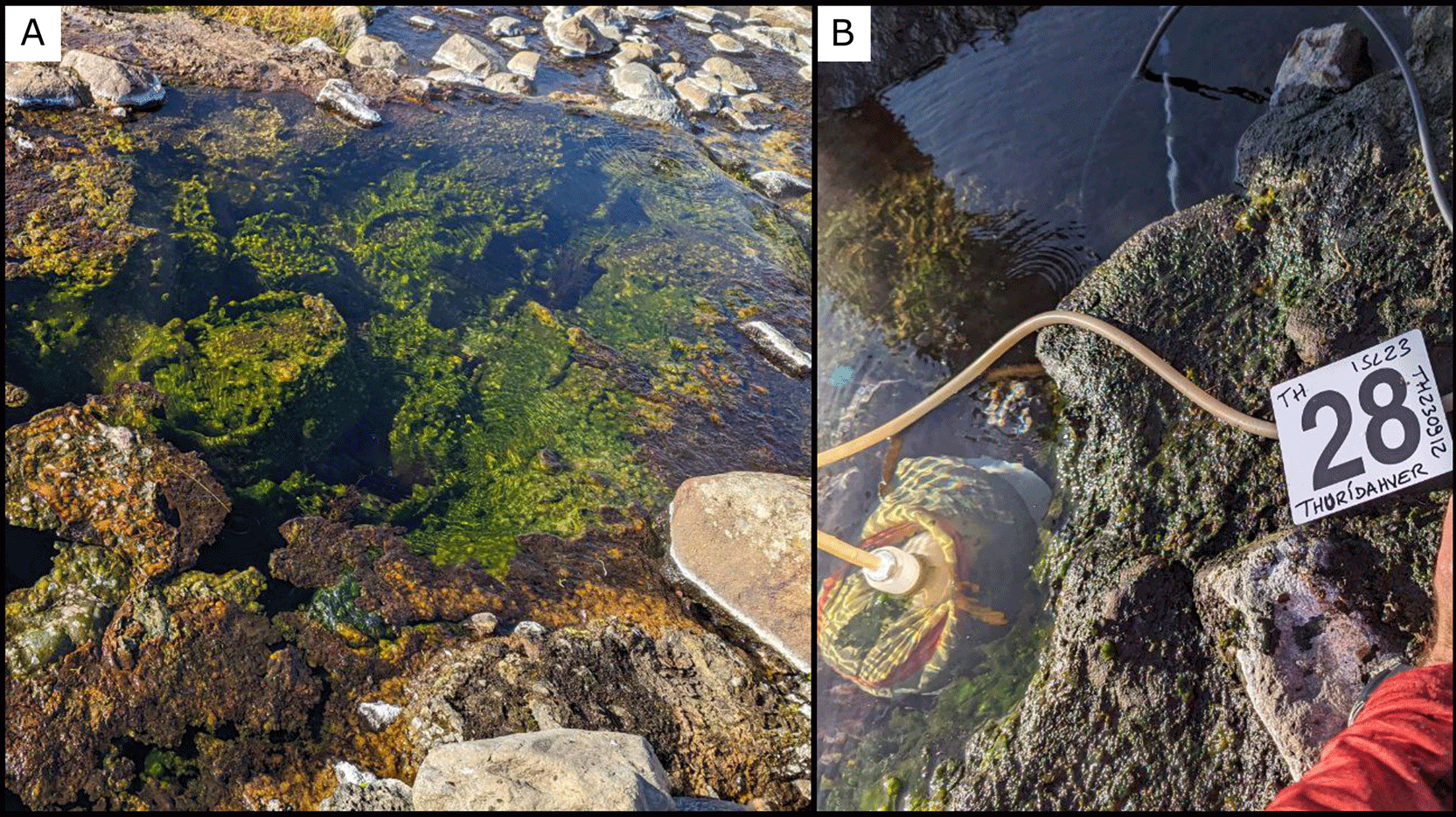
Figure 30. (A) A close-up view of the sampling location. (B) Close up of the emission point.
Photograph taken by author FM for this publication.
Site 29 Sesseljubær, SJ230913 (65.1127117 °N, −18.4315810 °E)
To reach the site SJ230913 from the cabins, we had to drive on poorly maintained roads and cross two rivers (
Figure 31). In a small valley at an altitude of 648 masl and 11 km far from the cabins, there is a small valley with a cabin next to a river. On the sides of the river there were a lot of small pools. In one of these we found a small flux of cold water (10.3°C) that we sampled. The pH measured there was 9.65.
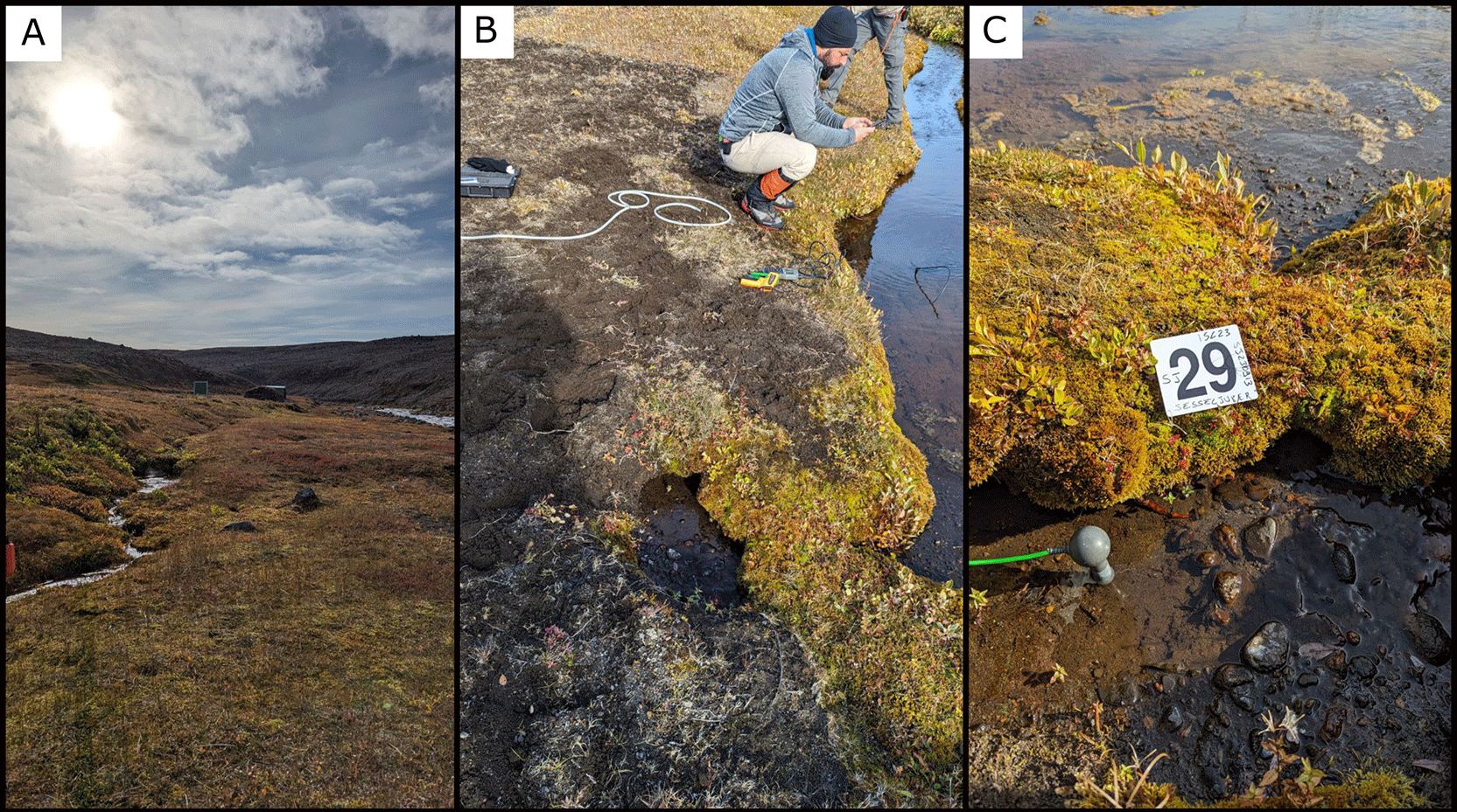
Figure 31. (A) An overview of the location chosen for the sampling. (B) Close-up view of the sampling location. (C) Close up of the emission point.
Photograph taken by author FM for this publication.
Site 30 Laugakvísl, LK230913 (65.0244250 °N, −18.3319267 °E)
The twenty-ninth site is an old artificial pool to accumulate the water coming out from the ground (
Figure 32). It is located at an altitude of 724 masl 300 meters from the Laugafell cabins, preceding the southeast direction. The temperature of the water was 40.3 and pH was 9.67. We sampled gas emission coming from the bottom of the pool (C).
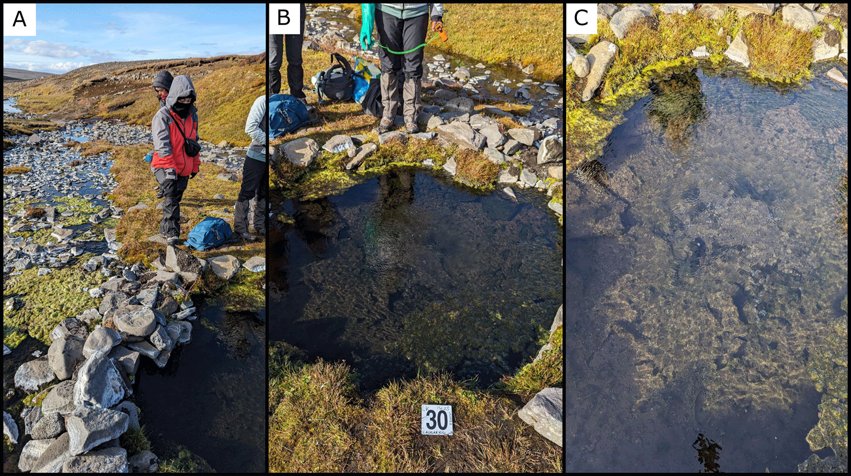
Figure 32. (A) Overview of the sampled site. (B) Close-up view of the sampling location. (C) Close up of the emission point.
Photograph taken by author FM for this publication.
Conclusion
The ISL23 expedition provided a comprehensive opportunity to explore the microbial diversity of Iceland’s geothermal ecosystems. By sampling a wide range of features we captured a diverse array of microbial communities that live in a variety of environments, with different ranges of temperatures, pH, and chemical conditions. Our approach of minimizing the interaction between subsurface fluids and the surface environment allowed us to collect robust geochemical and biological data reflecting subsurface processes at different levels of mixing with the surface, which will contribute to our understanding of microbial adaptation to such environments.
The data collected will enable us to investigate how microbial communities respond to the dynamic and extreme conditions of these geothermal habitats. The multidisciplinary approach used in this expedition, which combines geochemical and microbiological analyses, provides a holistic understanding of how geological processes influence microbial life. The results from this expedition will also contribute to ongoing discussions on the analogs between Earth’s geothermal environments and similar habitats on other planetary bodies, where subsurface hydrothermal activity could potentially host life.
Ethics and consent
Ethical approval and consent were not required.