Introduction
The continental and oceanic crusts host large and largely inaccessible microbial ecosystems, representing a substantial fraction of planetary biomass whose distribution, activity, and interactions with geological processes remain incompletely constrained (Kallmeyer et al., 2012; Bar-On et al., 2018; Magnabosco et al., 2018). These subsurface communities contribute to global biogeochemical cycles, influence the redox state of the crust and the mobility and transformation of volatiles, and have implications for the long-term evolution of planetary habitability (Falkowski et al., 2008; Magnabosco et al., 2018; D’Hondt et al., 2019; Giovannelli et al., 2021). Direct observation and sampling of subsurface ecosystems, however, remain limited by accessibility, cost, and scale (Giovannelli et al., 2021).
Scientific drilling has provided critical insights into the composition and activity of subsurface life (Harms and Emmermann, 2007; Soreghan and Cohen, 2013; Becker et al., 2019), but individual boreholes provide observations at discrete locations and cannot readily resolve the spatial heterogeneity and geological gradients that structure subsurface processes at regional scales. Thermal springs and deeply-sourced seeps, collectively referred to here as deeply-sourced seeps (Giovannelli et al. 2022), provide a complementary mode of access. These systems are surface expressions of subsurface fluid circulation, transporting dissolved compounds, volatiles, particles, and microbial communities shaped by water–rock interaction, thermal regimes, and biological activity along their flow paths (Deming and Baross, 1993; Giovannelli et al., 2022). Although they do not constitute direct samples of discrete subsurface horizons, they preserve integrated signals of processes occurring during fluid circulation and ascent. When sampled systematically across geological gradients, they can therefore be used to investigate geosphere–biosphere interactions across spatial scales that are difficult to access through drilling alone (Power et al., 2018; Barry et al., 2019; Fullerton et al., 2021; Giovannelli et al., 2022; Rogers et al., 2022; Upin et al., 2023; Basili et al., 2024).
A central challenge is that fluids emerging at the surface are modified during ascent and discharge through cooling, degassing, mixing with shallow groundwater and atmospheric gases, and interaction with surface-derived organic and mineral inputs (Barry et al., 2022, 2025; Giovannelli et al., 2022; de Moor et al., 2025). Sampling strategies must therefore both minimize surface overprinting and retain the information needed to evaluate it.
Here, we present a standardized field framework for microbiological and geochemical sampling of deeply-sourced seeps. Developed over the past decade across multiple projects and field campaigns, the framework integrates site and outlet selection, synoptic co-located sampling of multiple matrices, structured metadata acquisition, and approaches to assess the relative contribution of subsurface and surface signals. Although developed to address our specific research questions on subsurface geosphere–biosphere interactions, many components of the framework are modular and can be adapted to different scientific objectives, environments, and sampling requirements.
Conceptual framework
Deeply-sourced seeps as windows into the subsurface
In many geological settings, subsurface fluids migrate upward along permeable pathways and are expressed at the surface through thermal springs, bubbling pools, diffuse degassing areas, mud-rich seep zones, seep-fed sediments, and low-temperature hydrothermal manifestations. These systems transport fluids, dissolved solutes, gases, particles, and microbial cells that have interacted with the subsurface along their flow paths (Giovannelli et al., 2022). Here, following Giovannelli et al. (2022), these features are collectively referred to as deeply-sourced seeps.
This definition is based on connection to subsurface fluid circulation rather than temperature, morphology, or visual characteristics (Kresic, 2010). Temperature alone does not reliably indicate the strength of this connection: low-temperature seeps may reflect fluids that have cooled during ascent or mixed with shallow waters, while providing conditions compatible with sustained biological activity (Deming and Baross, 1993; Giovannelli et al., 2022). Restricting sampling to conspicuously hot systems would therefore capture only a subset of subsurface circulation and potentially exclude systems particularly relevant to microbial processes.
Deeply-sourced seeps do not represent discrete subsurface depth horizons, but integrate processes occurring along fluid pathways. Their chemical and biological composition reflects fluid–rock interaction, thermal and redox conditions, volatile exchange, mixing, and biological transformations experienced during fluid circulation and ascent (Giovannelli and Lloyd, 2026). The chemical and biological composition of a seep reflects the cumulative effects of processes distributed along these pathways, including mineral buffering, volatile exchange, and metabolic transformation.
Within this framework, seep systems are treated as integrative outputs of subsurface processes. Their value lies in the structured information they retain about the coupling between geology and biology during fluid ascent. The objective of field sampling is not to approximate direct access to the deep subsurface, but to resolve these integrated signals in a way that preserves their relationship to the processes that generated them. From this perspective, the relevant question is not whether a seep belongs to a particular category of hydrothermal activity, but the extent to which the sampled material reflects subsurface processes versus modification during ascent and near-surface emergence.
Synoptic, co-located sampling philosophy
If deeply-sourced seeps are treated as integrative outputs of subsurface processes, any data interpretation requires the different components of that integration within a common spatial and temporal framework (Giovannelli and Lloyd, 2026). No single dataset is sufficient; microbial community composition, fluid chemistry, gas composition, and geologic context each constrain different aspects of the system, and their interpretation depends on their alignment (Giovannelli et al., 2022).
The framework is therefore based on synoptic, co-located sampling, in which relevant measurements and sample types are collected from the same outlet during the same sampling event and linked through a shared metadata structure (Giovannelli et al., 2022; Shaffer et al., 2022). Co-location is defined operationally: samples must originate from the same physical system at the scale at which environmental gradients are resolved (
Figure 1). In deeply-sourced seeps, this scale is often on the order of centimeters to meters, over which temperature, redox conditions, and fluid composition can vary sharply. Collecting different sample fractions from spatially separated points within the same site can therefore introduce variability that is difficult to distinguish from process-driven differences, potentially confounding ecological and geochemical relationships.
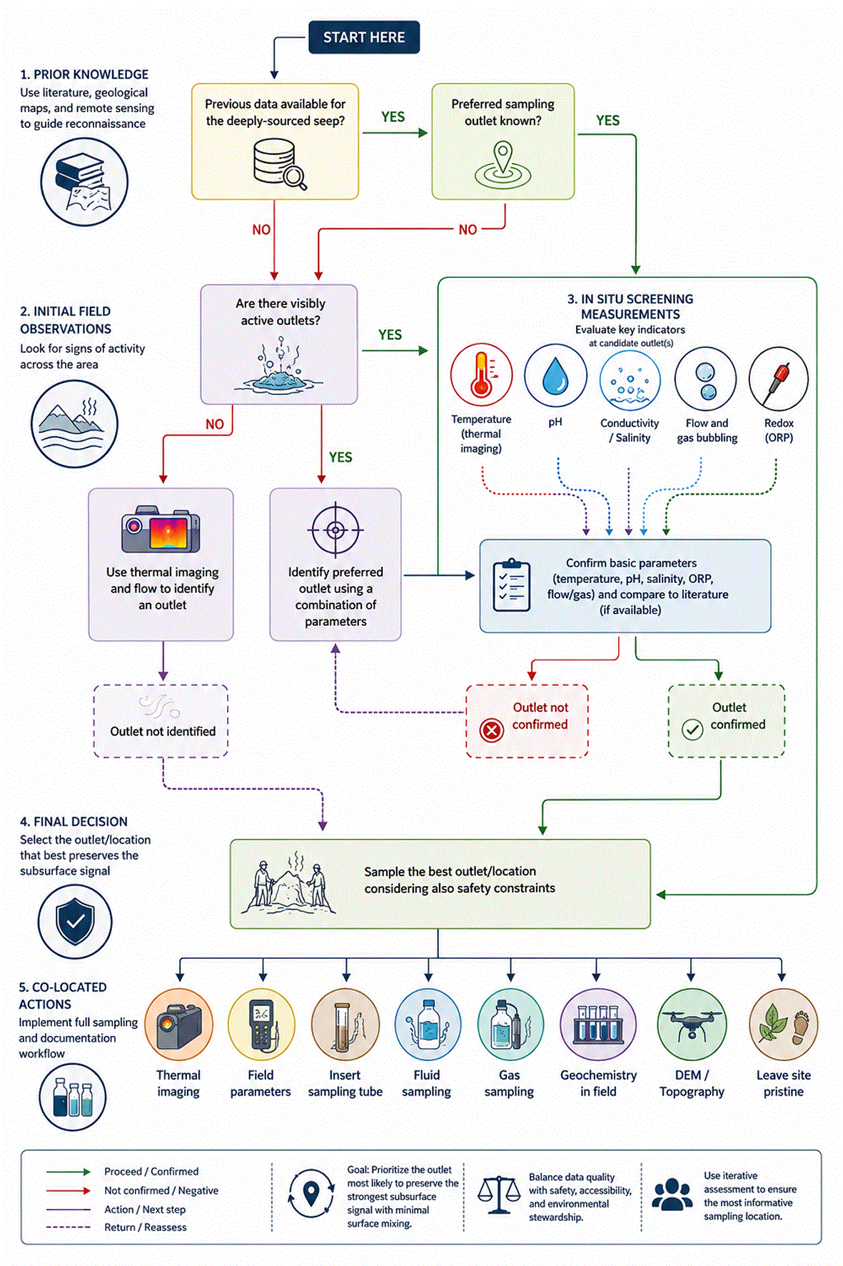
Figure 1. Decision tree for identification and prioritization of seep outlets in the field.
Operational workflow used to identify candidate seep systems and select the most informative sampling spot within each site. The decision tree integrates prior knowledge from literature, geological maps, and remote sensing with in situ observations, including thermal anomalies, visible discharge, pH, conductivity, salinity, oxidation–reduction potential, and gas or fluid flux. The aim is to prioritize the outlet most likely to preserve the strongest subsurface signal while minimizing surface mixing and preserving comparability among co-located sample types.
Temporal alignment is equally important because seep systems are dynamic. Discharge rate, gas flux, oxygen exposure, thermal structure, and other environmental conditions can vary over short to medium timescales. Measurements collected at different times may therefore represent different states of the system, even at the same location. Synoptic sampling requires biological, chemical, and physical measurements to be acquired within a temporal window that preserves their comparability.
This sampling philosophy also reflects the coupling among the processes being investigated. Fluid pathways are controlled by geological structures; water–rock interactions influence solute composition and buffering capacity; volatile transfer links subsurface reservoirs to surface discharge; and microbial activity both responds to and modifies these conditions, including during fluid ascent and within near-surface environments (Barry et al., 2019; Fullerton et al., 2021; Basili et al., 2024). The framework treats each sample type as part of a coupled system, where the value of each measurement derives from its relationship to the others. Synoptic, co-located sampling preserves these relationships and reduces the risk that apparent associations among biological, chemical, and geological variables arise from spatial or temporal mismatches.
Geological gradients as ecological drivers
The spatial scale of sampling is central to this framework. Microbial ecology has traditionally operated either at the scale of individual systems—through transects across springs, mats, vents, or redox interfaces—or at broader descriptive scales that are often detached from geological processes. Both approaches provide valuable insights, but neither alone resolves how subsurface ecosystems are structured within their geological context. Many processes relevant to subsurface life operate across large-scale geological gradients, and sampling strategies need to reflect these scales (Giovannelli et al., 2022; Cloetingh et al., 2023).
Subsurface ecosystems are embedded within tectonic, lithological, geothermal, and hydrological settings that influence fluid circulation and volatile flux (Giovannelli et al., 2022). Seep systems located in a convergent-margin forearc, along a hotspot track, within a rift basin, or in ultramafic terrains undergoing serpentinization represent distinct geological regimes rather than interchangeable environments. These settings structure fluid composition, the availability of electron donors and acceptors, the supply of rock-derived nutrients and inhibitors, thermal and redox histories, and fluid residence times. Biological variability among seeps may therefore reflect geological organization in addition to local ecological processes (Fullerton et al., 2021; Rogers et al., 2022; Paul et al., 2023; Upin et al., 2023; Basili et al., 2024).
Sampling across geological gradients makes this structure observable (Giovannelli et al., 2022). Along convergent margins, for example, variations in slab-derived inputs, mantle contributions, crustal interaction, and thermal regimes from trench to arc are reflected in fluid composition and microbial communities (Upin et al., 2023; Basili et al., 2024). Across volcanic provinces, differences in lithology, magmatic age, hydrothermal evolution, and volatile composition generate other structured gradients (Fullerton et al., 2021; Rogers et al., 2022; Paul et al., 2023). In older volcanic systems and hotspot tracks, these gradients may be time-transgressive, with seep systems sampling fluids influenced by magmatic bodies of different ages and stages of cooling (Giovannelli et al., 2024). In each case, sites are interpreted as elements of a geological gradient rather than as independent observations.
This distinction concerns process resolution as much as spatial scale (Giovannelli et al., 2022; Cloetingh et al., 2023). Local transects resolve how microbial communities respond to environmental gradients within a system, whereas geological transects test whether those responses persist across systems and map onto larger-scale geological controls. The two scales are complementary: one resolves ecological variation within habitats, while the other places that variation within the processes structuring the subsurface.
Temporal structure adds another dimension to this coupling. Subsurface microbial systems often operate under low energy fluxes, with long turnover times and persistent fluid–rock interactions. Geological processes such as fault-controlled circulation, hydrothermal cooling, and deep volcanic volatile inputs can also operate over extended timescales. Sampling deeply-sourced seeps across geological gradients therefore provides a practical means of examining biosphere–geosphere interactions across spatial and temporal scales that overlap with the processes generating the observed signals (Giovannelli et al., 2022).
Resolving subsurface and surface signals
Fluids sampled at seep outlets integrate source characteristics with processes occurring during ascent and discharge (Giovannelli and Lloyd, 2026). Cooling, degassing, oxidation, migration, mixing with shallow groundwater, atmospheric gas exchange, and interaction with surface materials can modify fluid composition and associated microbial communities. These processes are inherent to seep systems. Aside from contamination introduced by sampling or handling, the relevant question is therefore not whether a sample is “contaminated,” but to what extent it reflects subsurface processes versus modifications acquired during ascent and near-surface emergence. We treat this variation as a continuum rather than a binary distinction between subsurface and surface samples. Field sampling aims to minimize near-surface modification by targeting the least-mixed source fluids and limiting disturbance and atmospheric exposure. The remaining influence is evaluated using multiple independent geochemical, physical, and biological constraints (see Contamination assessment). This approach follows the general logic of endmember and tracer-based methods in hydrogeochemistry and isotope geochemistry, where multiple tracers constrain fluid sources, mixing, and subsequent modification (Clark and Fritz, 1997; German and Von Damm, 2006; Tóth and Katz, 2006; Gori et al., 2023). No single proxy is informative across all geological settings, and the combination used must reflect the characteristics of the system being sampled.
Relevant constraints include noble gas elemental and isotopic systematics, dissolved oxygen, carbon isotopic composition, salinity, alkalinity, redox-sensitive species, and other aqueous geochemical relationships. Biological information provides complementary constraints through, for example, phototrophic signatures, the distribution of obligately aerobic or anaerobic taxa, pigments associated with prolonged light exposure, and similarity to microbial communities in the surrounding surface environment (Giovannelli et al., 2022). Temperature and regional conductive and advective heat flow can further constrain the potential depth of habitable conditions (Giovannelli and Lloyd, 2026). These observations are interpreted together to position samples along a continuum from predominantly subsurface-derived to strongly surface-influenced conditions.
Importantly, intermediate or mixed systems are not necessarily less informative. Mixing, oxidation, cooling, and other transformations during fluid ascent and near-surface residence may themselves be processes of interest. The purpose of the framework is therefore not to exclude mixed samples, but to constrain their position along the subsurface–surface continuum so that they can be interpreted in the appropriate context.
The surface background strategy
Resolving surface influence requires characterization of the environment into which a seep emerges. Background soils, sediments, fluids, or waters are therefore collected from nearby areas that are not visibly affected by seep activity and that represent the local surface environment while minimizing direct hydrothermal or geochemical influence. These samples are not intended as strict experimental controls, which are rarely achievable in natural field settings, but as local references against which seep-associated biological and geochemical signals can be evaluated.
This comparison is particularly important in low-temperature and diffuse systems, where biomass, organic matter, detritus, spores, pigments, oxygenated porewater, and other surface-derived material can contribute substantially to the sampled material. For example, a microbial taxon enriched in a seep may represent a response to seep geochemistry, but its significance depends in part on its abundance in the surrounding soil, sediment, or water. Similarly, mineralogical or geochemical signatures that appear distinctive in a seep may also characterize the local substrate. Background samples provide the environmental context needed to distinguish these possibilities.
The background matrix is selected according to the environment being sampled. In continental systems, background soils or unaffected surface waters can be collected alongside seep fluids and sediments; in submarine systems, background seawater and unaffected sediments provide the corresponding reference. Similarity between seep and background samples can then be incorporated explicitly into the assessment of surface influence, including microbial community composition, pigment distributions, and shallow organic matter signatures. In this way, the surrounding environment is treated as part of the system influencing the material recovered at the outlet rather than as an external source of uncontrolled “contamination.”
Field strategy and site selection
Site selection criteria: literature, remote sensing, and geologic maps
Pre-field prioritization is guided by whether candidate seeps can be placed within a defined geological framework (
Figure 1). The target is not an isolated hydrothermal feature, but a seep that can be interpreted as part of a structured geological system: along transects across subduction margins, within volcanic provinces of known age, along fault-controlled discharge zones, at lithological contacts such as basalt–gneiss interfaces (Giovannelli et al., 2024), or across gradients in salinity, pH, or redox conditions. Site selection therefore considers the relationship between individual seeps and larger-scale geological structures (Cloetingh et al., 2023), subsurface fluid circulation (Basili et al., 2024) and geosphere–biosphere interactions (Fullerton et al., 2021; Rogers et al., 2022). Selection is necessarily also opportunistic and constrained by prior knowledge, accessibility, permits, and logistics. In Greenland, for example, candidate seeps identified from published information were positioned within an island-scale framework defined by fault systems, lithological contacts, and known or inferred thermal manifestations (Giovannelli et al., 2024). In Iceland, geological structure and existing measurements, including temperature, pH, and 3He/4He ratios, were considered alongside accessibility and landowner permission (Montemagno et al., 2026).
Remote sensing and geospatial information support site selection and reconnaissance. Satellite imagery, orthophotos, drone reconnaissance, and thermal data can be used to evaluate accessibility, spatial organization, and the presence of potential discharge points. Vegetation patterns and mineralogical anomalies may indicate persistent discharge or thermal stability, but are treated as indicators requiring in situ validation rather than diagnostic criteria. In Greenland, for example, vegetation assemblages helped identify potential homeothermic systems that were subsequently evaluated in the field. Geological maps are used to identify lithological boundaries, structural controls, potential fluid pathways, eruptive centers, sedimentary basins, and degassing zones relevant to seep chemistry and biology. Together, these sources guide reconnaissance and place candidate sites within their regional geological context.
Local knowledge is integrated into site selection and field planning. Local researchers, technical experts, and, where relevant, community members can provide information on seep locations, access routes, temporal variability, and site-specific hazards that is absent from published datasets, maps, or remote sensing products. This information is considered alongside literature and geospatial data when refining site priorities and sampling plans. Whenever possible, local collaborators are involved in the codesign of field activities and scientific questions, and data generated during the campaign are shared with collaborating institutions and stakeholders (Odeny and Bosurgi, 2022; Laumann et al., 2025).
Identification of seep systems and sampling locations
At each locality, field reconnaissance is used to identify the seep system and the specific location to be sampled (
Figure 1). The primary criterion is not whether a feature is visually prominent, but whether it shows evidence of subsurface-derived discharge. Relevant indicators include visible or diffuse emergence of fluids or gases, thermal or chemical anomalies relative to the surrounding environment, focused outflow from a defined source zone, and spatial gradients that distinguish source fluids from mixed or downstream waters. The objective is to sample as close as possible to the point of emergence and where modification by surface processes is minimized, while accounting for accessibility and safety.
Visual inspection provides the first level of field assessment. The setting of the seep is recorded, including whether discharge occurs within a pool, streambed, beach sediment, fumarolic field, rock fracture, marsh, mud cone, or runoff zone. The morphology of the discharge area is documented through photographs, sketches, and field-log annotations, including the number and distribution of outlets, pooling, bubbling, precipitates and mineral crusts, vegetation, redox zonation, sediment texture, flow direction, and evidence of seasonal or tidal influence. These observations establish the spatial context of the system and guide subsequent measurements and sampling.
In systems with focused discharge, the sampling location may be readily identified from discrete orifices, gas vents, bubbling zones, or well-defined thermal anomalies. Diffuse or low-temperature systems, including beach springs, sediment-hosted seepage, and shallow hydrothermal fields, generally require additional screening. Temperature, conductivity, pH, salinity, oxidation–reduction potential, and dissolved oxygen can be measured across the system to resolve spatial gradients and identify the least-mixed endmember. The variables used depend on the system: a thermal gradient may be diagnostic at one site, whereas salinity, redox conditions, or gas discharge may provide stronger constraints at another.
Thermal imaging can complement these measurements where discharge is diffuse or spatially complex. It can distinguish active discharge from mixed ambient waters, resolve subtle temperature gradients, and identify thermal inputs beneath vegetated or sediment-covered surfaces (Bastoni et al., 2024). In higher-temperature systems, thermal imaging can also inform placement of sampling equipment and safe access. Where appropriate, drone surveys provide a broader spatial context through orthomosaics, high-resolution imagery, and digital elevation models. These products can locate outlets within their microtopographic and geomorphological setting, including drainage pathways, terrace position, structural features, sediment transport zones, and coastal mixing interfaces. They are particularly useful for spatially extensive seep systems and for sites revisited over time, where discharge locations may shift.
The final sampling location is selected by integrating these observations and measurements. In all cases, sampling targets the position that best preserves the subsurface signal rather than simply the most conspicuous feature. A single locality may contain multiple outlets representing different flow paths or degrees of mixing; where these represent distinct hydrological or geochemical domains, they are treated as separate sampling sites. The selected location and the observations used to define it are recorded in the field log, and associated visual, thermal, and drone datasets are linked to the corresponding identifiers.
Prioritization of sampling outlets: temperature, pH extremes, salinity, ORP, and flux
When multiple candidate outlets are present within a seep system, sampling is prioritized toward the location most likely to preserve the subsurface signal with the least near-surface modification. Temperature is an informative parameter but is not used as a standalone indicator of subsurface origin. Low-temperature outlets may still represent deeply circulating fluids, particularly in older volcanic terrains, forearc settings, or systems where fluids cool substantially during ascent. Outlet selection therefore considers temperature together with pH, conductivity or salinity, oxidation–reduction potential (ORP), dissolved oxygen, gas discharge, and hydrological focus (
Figure 1). Priority is generally given to outlets showing the strongest and most coherent anomalies relative to the surrounding system, particularly where these coincide with focused fluid or gas discharge. Depending on the system, this may correspond to extremes in temperature, pH, salinity, redox conditions, or flux rather than to the highest-temperature outlet.
The parameters used for prioritization are site-specific. In acid-sulfate systems, for example, low pH and sulfide or iron signatures may provide stronger constraints than temperature. In coastal hydrothermal systems, salinity and dissolved oxygen may better resolve mixing with seawater. In gas-rich terrestrial systems, gas flux and redox anomalies may identify the most direct discharge. In stratified pools, the least-modified fluid may occur beneath microbial mats or mineral precipitates rather than at the warmest surface location. No universal thresholds are applied: outlets are ranked according to relative contrasts within each seep system and the combination of indicators most appropriate to its geological and hydrological setting.
Accessing source fluids and minimizing surface mixing
Following selection of the sampling location, fluids are accessed at the point where surface modification is minimized relative to the rest of the system. Inert sampling tubes, typically titanium, are inserted to intercept the fluid below the main mixing interface. In shallow or sediment-rich environments and wells, Teflon or PVC bailers can be used where appropriate for the target analyses. Where discharge occurs through unconsolidated sediments, the sampling tube is inserted to a depth sufficient to bypass the visibly mixed surface layer. In systems with focused gas discharge or fracture-controlled flow, the sampling line is positioned as close as possible to, or within, the point of fluid or gas emergence. Placement is performed with minimal disturbance, and physicochemical parameters can be re-measured after insertion to verify that access to the source has not substantially altered local conditions.
Surface mixing is minimized throughout the subsequent sampling sequence. Collection rate is adjusted to the natural discharge of the seep to avoid inducing flow from surrounding or overlying waters. In static systems, excessive withdrawal can draw water from the margins or overlying layers, while in flowing systems it can entrain oxic or surface-derived water along the flow path. Sampling should therefore not exceed local replenishment. In low-flow systems, this may require slow collection and prioritization of analytical fractions; partial sampling under stable conditions is preferable to complete sampling that alters the system and introduces mixing artifacts.
Before analytical samples are collected, dead volume in tubing, syringes, and connectors is flushed and the sampling system is conditioned with several volumes of source fluid or gas. Sampling order is then adapted to preserve the most sensitive fractions and minimize cross-contamination. Dissolved and noble gases, DIC/DOC, and other gas-sensitive fractions are generally collected before bulk geochemistry or microbiological filtration, provided that this does not increase the risk of microbial contamination. A single fixed sampling sequence cannot be applied to all sites because outlet geometry, flow conditions, analytical priorities, contamination risks, and safety constraints vary among systems.
Operator position and disturbance of the sampling area are also considered. Where possible, the operator works downstream of the outlet, avoids disturbing sediments before fluid or gas collection, and minimizes contact with pool margins or overlying layers that could mix surface and source waters. In systems affected by external forcing, such as beach springs or intertidal seeps, sampling is timed relative to tidal stage, wave action, or local hydrology to minimize short-term variability. These conditions and any deviations from the standard sampling procedure are recorded in the field log.
Sampling design
Sampling units: the “series” concept
The core operational unit of the framework is the sampling series (
Table 2). A series is defined as the complete set of pre-labeled containers, filters, preservation reagents, and associated metadata templates required to characterize a single seep outlet or defined sampling location within a site. It establishes in advance the analytical structure of the material to be collected. Preparing the series before field deployment standardizes sampling across sites and campaigns, maintains the link between field samples and downstream analyses, and reduces variability introduced by in-field decisions and labeling errors. The relationship between physical samples and their intended analytical workflows is therefore defined at the time of collection rather than reconstructed post hoc.
Table 1. Sample types, preservation methods, storage conditions, and target analyses in the standardized field framework.
Comprehensive overview of the matrices routinely collected from deeply-sourced seeps, including fluids, gases, sediments, biofilms, and background soils, together with their typical volumes or masses, collection containers, preservation procedures, recommended storage conditions, and intended downstream analyses. The table defines the standard analytical architecture of a single sampling series and serves as the reference guide for field preparation and sample handling.
| Sample type |
Code | Typical volume/mass | Container | Preservation | Storage | Target analyses |
|---|
| Fluid biomass (molecular) | F | ~2 L (3× filters) | Sterivex 0.22 μm | None/storage buffer | −20 °C | Metagenomics, metabarcoding |
| Fluid (geochemistry) | Geo F | ~40 mL | 50 mL Falcon | Filtered (0.22 μm) | +4 °C | Major ions, nutrients, dissolved species |
| Fluid (trace elements) | Geo F acid | ~40 mL | Acid-washed 50 mL Falcon | Filtered (0.22 μm) + HNO3 (~2%) | +4 °C | Trace metals |
| Fluid (DIC/DOC) | ISO | ~10 mL | Acid-washed and hashed 10 mL glass vial | Crimped (air free, no headspace) | +4 °C | δ13C-DIC, δ13C-DOC, H2O isotopes, dissolved carbon concentrations |
| Fluid (bulk) | – | 0.5–1 L | PP bottle (no headspace) | None | +4 °C | Backup/additional analyses |
| Sediment (molecular) | S | ~40 g | 50 mL Falcon | None | −20 °C | Metagenomics, metabarcoding |
| Sediment (geochemistry) | GEO S | ~40 g | Acid-washed 50 mL Falcon | None | −20 °C | Mineralogy, elemental composition, trace metals |
| Biofilm | B | variable (~5–20 g) | Falcon/glass vial | None | −20 °C | Metagenomics, metabarcoding, elemental composition |
| Background soil | BG | ~40 g | 50 mL Falcon | None | −20 °C | Surface reference (biology + chemistry) |
| Background water/fluids biomass (molecular) | BGW or BGF | ~2 L (3× filters) | Sterivex 0.22 μm | None/storage buffer | −20 °C | Metagenomics, metabarcoding |
| Background water/fluids (geochemistry) | Geo-BGW or Geo-BGF
| ~40 mL | 50 mL Falcon | Filtered (0.22 μm) | +4 °C | Major ions, nutrients, dissolved species |
| Gas (reactive) | G | ~250 mL bottle | Giggenbach bottle (NaOH) | CO2 trapped in solution | RT | Gas composition (GC), δ13C-CO2 |
| Gas and dissolved gas (noble) | NG | ~10–20 mL | Copper tube | Clamped (air-free) | RT | He, Ne, Ar isotopes |
| Dissolved gas | DG | variable | Giggenbach bottle (NaOH) | CO2 trapped in solution | RT | Dissolved gases (H2, CH4, CO2, etc.) |
| Enrichment culture | A | ~20–100 mL | Anaerobic vial 250 mL | Crimped (air free, no headspace) | +4 °C | Cultivation, metabolic assays |
| Cell counts (fluid) | PCF | ~2 mL | Cryovial | 2% formaldehyde | +4 °C | Cell abundance and biomass |
| Cell counts (sediment) | PCS | ~1 g | Cryovial | 2% formaldehyde | +4 °C | Cell abundance and biomass |
| Particulate organic matter | POM | ~200 mL | GFF filter 0.3 μm (ashed) | Frozen | −20 °C | Particulate organic matter concentrations, δ13C-POM, δ15N-POM
|
Table 2. Hierarchical identifier system for environmental samples collected in the CoEvolve framework.
Definition of the four identifier levels used for sample tracking—ExpID, SiteID, CollectionID, and SampleID—together with their conceptual role, syntax, examples, and rules of use. The table clarifies the separation between identity and metadata, the relationship between canonical and compacted field forms, and the role of SampleID as the primary key linking field samples to downstream analytical data. Typical examples: F – fluid, B – biofilm, S – sediment, R – rock, G – gas, SW – seawater, SS – soil sample. Every code has a canonical code for database (ITA25_ARC_250103A_F) and a compact code for labelling (ARC250103AF).
| Level | Identifier | Definition | Sinthax | Synthx rules | Syntax example | Rules |
|---|
| Expedition | ExpID | Project or expedition context | XXXYY | [XXX] defined as either the Country ISO 3166-1 alpha-3 code or the project code and the [YY] is generally the year of the project | ISL23, AEO25, EXT25 | Immutable |
| Site | SiteID | Spatial locality (WGS84) | [ZZZ] | [ZZZ] defined as three alphanumeric characters that identify a unique locality on the surface of the planet (in 2D space). This means that depths or multiple quotes at a single location (drilling, water column, etc, are handled separatedly). Legacy SiteID were occasionally two characters [ZZ] | ARC, SD1, BQR, RCA | Reused across visits |
| Collection event | CollectionID | Site + date (+ modifiers) | SiteID_YYMMDD [modifier] | CollectionID identifies a unique sampling event defined by where (SiteID) and when (date). Modifiers can be used to represent multiple samples in a day from the same SIteID or multiple depths, or freely | BQ1_220911, VQA_230208, ARC_250103A | Unique per sampling event |
| Sample | SampleID | Unique physical sample type | CollectionID_T | SampleID is the true unique identifier sample identifier of the system. It identifies a unique physical sample type collected during a CollectionID. A SampleID may correspond to multiple physical containers (vials, filters, bags) that all derive from the same material and are intended for different analyses. Aliquots/containers are tracked in separate metadata tables linked to the parent SampleID. [T] is one or more alphanumeric characters that identifies the type of sample such as F (fluids), S (sediments), B (biofilm), G (gas), SW (seawater), SS (soil), etc … | ARC_250103A_F, BQ1_220911_S, VQA_230208_SS,
| Primary key. SampleIDs are never changed or reused |
Each series is organized around synoptic, co-located sampling. Fluid, gas, sediment, and biological material are collected as components of the same sampling event, allowing chemical, isotopic, and biological measurements to be interpreted within a shared spatial and temporal context. In the implementation described here, a standard series includes triplicate Sterivex filters for fluid-associated biomass, filtered fluid aliquots for aqueous geochemistry, acidified aliquots for trace-element analysis, cryovials for cell counts, anaerobic culture vials, isotope samples, and additional containers for particulate organic matter and gas analyses. This configuration reflects the analytical requirements of our work on geosphere–biosphere interactions in deeply-sourced seeps. The series itself is modular: individual sample types and analytical fractions can be added, omitted, or modified according to the scientific objectives, characteristics of the system, and logistical constraints, while retaining the same organizational structure.
Sample identification and data architecture
The field framework uses a hierarchical identifier system designed to preserve sample identity, provenance, and relationships across field observations, analytical workflows, and data repositories (Shaffer et al., 2022). It provides a simplified operational structure informed by Darwin Core (Darwin Core Quick Reference Guide, n.d.), the MIxS Standard (Yilmaz et al., 2011) and the ISA-tab metadata standard (González-Beltrán et al., 2014), while remaining practical for field use. The hierarchy comprises ExpID, SiteID, CollectionID, and SampleID (
Figure 2), representing respectively the expedition or project, geographic locality, sampling event, and sample type collected during that event.
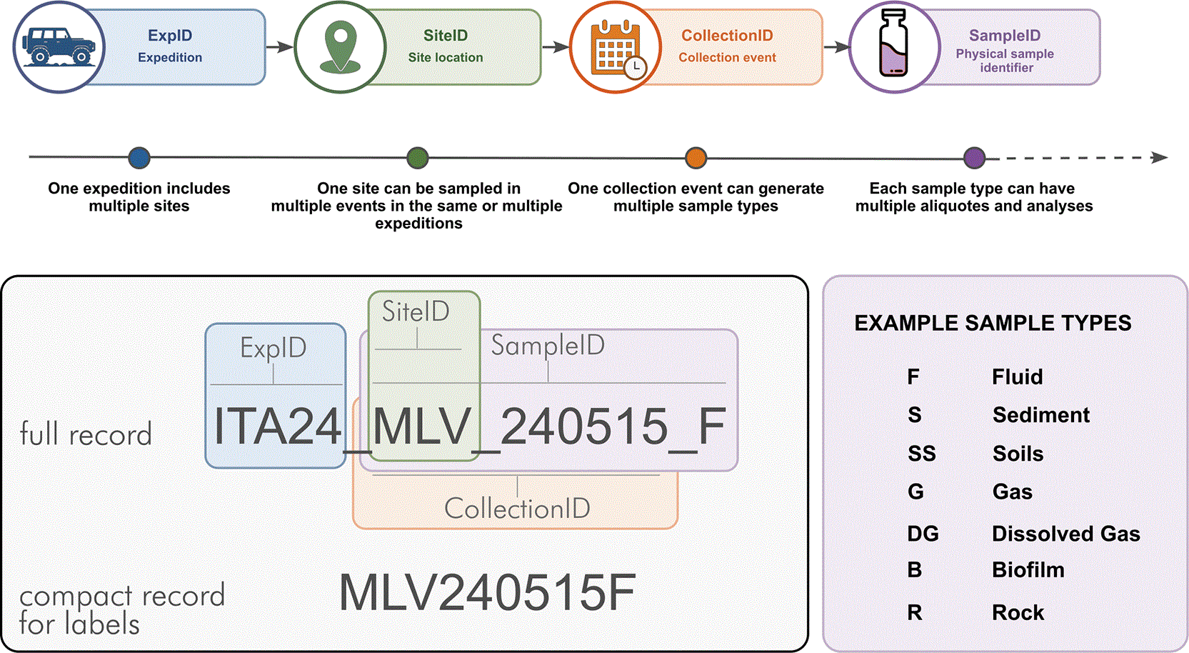
Figure 2. Hierarchical sample identification system used in the CoEvolve field framework.
Structure of the identifier architecture linking expedition, site, collection event, and physical sample type. The system is composed of ExpID, SiteID, CollectionID, and SampleID, each representing a distinct dimension of sample identity. The figure illustrates the conceptual dependence among identifier levels, the distinction between canonical database format and compact field labeling.
The SampleID identifies the sampled material rather than its subsequent analytical destination. For example, fluid (F), sediment (S), and surface soil (SS) collected during the same event are assigned distinct SampleIDs under a common CollectionID. A single sample may then be distributed among multiple containers or analytical workflows. These are identified using secondary operational codes—for example, ISO for isotope analysis, GEO for aqueous geochemistry, or PCF for fluid cell counts—but these codes do not form part of the primary identifier hierarchy. Consequently, measurements generated through different analytical streams remain traceable to the same original sample. This distinction is particularly important for synoptic sampling, where biological, chemical, and isotopic measurements must remain explicitly linked to the same material collected at the same place and time.
The primary identifiers are intentionally minimal and do not encode analytical methods, preservation conditions, operator information, or other contextual descriptors, which are maintained as metadata. This separation allows the primary identifier to remain stable as samples move through different analytical workflows and as methods evolve. A site can be revisited across campaigns, each visit can include one or more collection events, and each event can generate multiple sample types and analytical fractions without changing the underlying identifier structure.
The field log provides the operational link between identifiers and metadata. Coordinates, environmental conditions, field measurements, sampling context, processing details, and other observations are recorded against the corresponding identifiers at the time of collection. The resulting architecture links each analytical result back through the sampled material and collection event to its spatial, temporal, and environmental context.
Standard per-site architecture
For each prioritized outlet, the standard series comprises a consistent set of sample types, with deviations recorded when complete collection is not feasible or when additional samples are required by specific scientific objectives (
Table 1). In fluid-emitting systems, this typically includes fluid for molecular analyses, major ions and nutrients, trace elements, dissolved inorganic and organic carbon, and reactive and noble gases; gas samples for reactive and noble gas analyses; sediment from the outlet zone; biofilm where present; background soil, sediment, or water representative of the surrounding environment; and preserved fluid and sediment aliquots for cell counts and enrichment cultures. The number and volume of samples within each category may vary with local conditions and campaign objectives, while the overall architecture of the series is maintained through standardized field kits and packing lists.
The composition of each series is defined at the CollectionID level, with each collected matrix assigned its corresponding SampleID. Individual containers and analytical fractions are tracked using secondary operational codes linked to that SampleID rather than through additional levels in the primary identifier hierarchy. This preserves a stable relationship between the original sampled material and the multiple analytical datasets generated from it.
Sample types and analytical rationale
Fluids constitute the primary integrative matrix sampled from deeply-sourced seeps. They transport dissolved products of water–rock interaction, volatile exchange, and microbial metabolism along the flow path, together with suspended and planktonic biomass. Fluid samples therefore link aqueous geochemistry, dissolved gases, and microbial communities within the same transported matrix. At collection, the fluid is partitioned among analytical fractions targeting molecular analyses, aqueous and trace-element geochemistry, carbon and other isotopes, dissolved gases, cell abundance, and cultivation. These complementary measurements resolve processes occurring simultaneously within the fluid phase, including redox transformations, carbon cycling, volatile transport, and microbial activity.
Sediments, gases, and biofilms provide complementary information that is not fully captured by the fluid phase. Sediments collected at or near the outlet record processes at the fluid–solid interface, including mineral precipitation and dissolution, redox gradients, and attached microbial communities. They can capture transformations such as sulfur and iron cycling or organic matter turnover that are spatially localized at the discharge interface. Gas samples resolve the volatile component of the system, with free and dissolved gases representing distinct but complementary phases. Free gases provide information on volatile composition and potential mantle, crustal, or biogenic sources, whereas dissolved gases reflect exchange with the aqueous phase and the fraction directly available for microbial production or consumption. Reactive gases constrain redox processes and potential metabolic substrates, while noble gases provide tracers of fluid origin and mixing and, together with measurements such as 14C of dissolved CO2, can constrain fluid residence times (Barry et al., 2025). Biofilms provide a spatially resolved biological matrix at the interface between seep fluids and the surface environment. Although not a primary target of the framework, sulfur mats, iron-rich films, filamentous growths, and pigmented microbial layers can capture microbial responses to steep local physicochemical gradients that may be weakly represented in bulk fluids or sediments.
Background soils, sediments, fluids, or waters provide the local surface reference described in the conceptual framework. The appropriate matrix depends on the seep environment and is selected to represent the surrounding system while minimizing direct influence from seep discharge. Comparison with these samples helps constrain the contribution of local surface microbial communities, organic matter, and geochemical characteristics to seep-associated samples and provides one of the references used to position samples along the subsurface–surface continuum.
Sample collection protocols
Fluids
Fluid collection sequence is adapted to the local seep structure and flow rate, to preserve gas-sensitive and isotope-sensitive targets and reduce the risk that agitation, air entrainment, or disturbance of the seep will modify microbiology, volatile concentrations or isotopic composition. Following interception of the outlet and flushing of all lines, fluid is routed sequentially to the required containers. This can be obtained using gravity flow or peristaltic pumps, such as the 3D printed peristaltic pumps we have developed for remote field applications (Selci et al., in prep). This approach is also used to collect fluids for the multiparametric probe when it cannot be inserted safely within the outlet. For molecular analyses, approximately 2 L of fluid are filtered, typically in triplicate, through 0.22 μm Sterivex cartridges (Millipore Sterivex SVGP01050). The objective is to capture suspended microbial biomass while preserving the chemical integrity of the fluid (
Table 1). Filters are immediately frozen in the field or as soon as the logistics allows it. Filtered fluids, after allowing several volumes of fluids to flow through for filter conditioning, are then partitioned into analytical fractions for geochemical analysis. Aliquots for major ions, nutrients, and general field aqueous geochemistry are collected into falcon tubes. Parallel aliquots are transferred into acid-washed containers and acidified with nitric acid to approximately 2% final concentration for trace element analysis. For dissolved inorganic and organic carbon and associated isotopic measurements, filtered fluid is transferred into acid washed, ashed glass vials without headspace. Bulk fluid collection is performed only after analytically sensitive fractions have been secured. In low-flow or structurally delicate systems, complete collection of all fractions may not be possible without inducing mixing. In such cases, priority is given to irreplaceable aliquots, and omitted fractions are recorded in the field log.
Sediments
Sediment sampling targets material actively interacting with seep fluids at or immediately adjacent to the outlet. Collection is performed using stainless steel or inert plastic tools, with selection based on analytical requirements. Surface debris and allochthonous organic material are excluded unless explicitly required by the sampling objective. For molecular analyses, sediment is transferred to sterile 50 mL conical tubes and frozen as rapidly as field conditions allow. For solid-phase geochemistry, isotopic work, or reactive phase analyses, parallel aliquots are collected into designated containers, including acid-washed vessels where appropriate. Separate aliquots are maintained for molecular and geochemical analyses to avoid cross-contamination and to accommodate different preservation requirements. This separation is tracked through metadata and sample type codes rather than through modifications of the identifier structure.
Biofilms
Biofilms are sampled only where they are clearly distinguishable from surrounding sediment and directly associated with seep discharge. Collection is performed using sterile tools and the sample is homogenized unless preserving visible structures and stratification is explicitly required by the study design. For enrichment or cultivation, biofilm may be transferred together with fresh seep fluid into glass or anaerobic vials, maintaining minimal headspace where possible. This approach preserves the redox and chemical context sufficiently to support downstream cultivation attempts.
Background samples
Background samples are collected outside the visible or inferred influence of seep discharge and selected to represent the relevant local surface environment. Depending on the setting, these may include water upstream of a seep, seawater outside the inferred zone of geochemical or volatile influence, unaffected sediments, or soils located upslope or away from the discharge system. Sampling locations are selected to minimize direct input from seep-derived fluids, aerosols, transported sediment, or other obvious seep influence. Background samples are collected and preserved using procedures equivalent to those applied to the corresponding seep matrix. In particular, samples intended for molecular analyses are frozen under the same conditions as seep samples. Consistent collection, preservation, and storage are maintained to allow direct comparison between seep and background samples.
Gas samples: dissolved and free gas
Gas sampling is divided into reactive gas and inert noble gas workflows, with separation between free and dissolved phases. The sample tubing line is flushed extensively, typically exceeding ten tubing volumes, before samples are collected. For reactive and major gas composition, samples are collected in pre-evacuated 250 ml Giggenbach bottles containing 5 M NaOH solution (de Moor et al., 2025). This configuration allows trapping of CO2 in solution while preserving headspace gases for chromatographic analysis. Depending on the system, these bottles are used for both free gas and dissolved gas collection. Larger volumes might be used if specific downstream analysis is required. For both free and dissolved noble gases isotopic analysis, fluid is transferred through silicone tubing into copper tubes (Barry et al., 2019, 2022, 2025) and stainless steel clamps are applied to both ends to isolate the sample. Subsequent laboratory analyses may include gas chromatography of headspace components, titration of trapped CO2, and isotope measurements. Field collection is structured to preserve compatibility with these workflows.
Cultures and cell count preservation
Samples for cell counts are preserved immediately to arrest biological activity. Fluid aliquots are transferred to cryovials containing formaldehyde or paraformaldehyde to a final concentration of approximately 2–3%. Sediment samples are preserved in parallel by subsampling into cryovials containing fixative and sterile water. Samples are stored cold, typically at 4 °C, until processing. Samples intended for cultivation are handled differently. Fluid, biofilm, or sediment is transferred into anaerobic culture vials or glass containers with minimal headspace. These samples are maintained under conditions that preserve viability and redox state, typically by minimizing oxygen exposure and storing at low temperature without freezing. This distinction between preserved and viable samples is maintained throughout the series architecture.
Field observations and in situ measurements
Field observations and in situ measurements are acquired at each sampling location to characterize the conditions under which samples are collected and provide the environmental, geological, and hydrodynamic context required for their interpretation. Measurements are made as close as possible to the sampling point and time and are linked to the corresponding identifiers in the field log. The core measurements, methods, and instrumentation used in the framework are summarized in
Table 3.
Table 3. In situ field measurements acquired during sampling of deeply-sourced seeps.
Summary of the core physicochemical, geochemical, and contextual measurements collected in the field, including parameter name, analytical principle or method and instrument or kit used.
| Parameter | Method | Instrument | Notes |
|---|
| GPS coordinates | WGS84 | GPS | Mandatory |
| Weather conditions | Observation | Air thermometer /Anemometer/Compass | Contextual metadata |
| Thermal imaging | Infrared | Thermal camera | Outlet identification, general thermal context |
| Temperature | Direct probe | Multiparameter probe/thermocouple | Measured at outlet |
| pH | Electrode | Multiparameter probe | Calibrated daily |
| Conductivity/SPC | Electrode | Multiparameter probe | Proxy for salinity |
| Salinity | Derived/probe | Multiparameter probe | Context-dependent
|
| Dissolved oxygen (DO) | Optical/electrode | Multiparameter probe | Indicator of mixing, measured both as absolute concentration and relative saturation |
| ORP (Eh) | Electrode | Multiparameter probe | Relative redox proxy |
| Total dissolved solids (TDS) | Derived/probe | Multiparameter probe | Influenced by sampling operations |
| Density | Optical | Field densimeter | Must be temperature corrected |
| Total alkalinity | Titration | Field kit | Immediate preferred |
| Dissolved silica | Colorimetric | Field spectrophotometer | Sensible to temperature changes |
| Total sulfide | Kline assay | Field spectrophotometer/Zn acetate | Redox-sensitive
|
| Fe (II) | 1,10-phenanthroline colorimetric method | Field spectrophotometer | Redox-sensitive
|
| Gas flux | Volumetric | Field estimate | Where possible |
| Fluid flux | Volumetric/flow meter | Field estimate | Where possible |
| Drone DEM | Photogrammetry | UAV | Spatial context |
Geological, geospatial, and visual documentation
Geological context is documented by integrating available geological maps and regional information with direct field observations. Regional setting, lithology, major structures, and other site-scale information are associated with the SiteID, while observations specific to the outlet are recorded for the corresponding CollectionID. At the sampling point, the substrate and local setting are described, including whether discharge occurs through bedrock, fractures, unconsolidated sediment, or mixed substrates, together with relevant structural and geomorphological relationships.
Each sampling point is georeferenced using GPS coordinates in WGS84 decimal degrees (dd.dddddd°). Coordinates are recorded at the actual sampling point rather than at a general site location, and positional uncertainty is noted where relevant. Visual documentation forms part of the field record. Photographs include the broader site setting, the outlet and its immediate surroundings, the sampling configuration, and geological, geomorphological, mineralogical, or biological features relevant to interpretation. Additional annotated photographs or field sketches are used where spatial relationships or observations cannot be adequately captured in the standardized fields of the field log.
Environmental conditions
Environmental conditions are recorded at the time of sampling as contextual metadata. These include air temperature, time of day, cloud cover or solar exposure, wind speed and direction, recent and ongoing precipitation, and hydrological conditions where relevant, such as tidal stage, stream flow, or standing-water level. These observations document short-term conditions that may influence seep expression or modify the sampled system through processes such as dilution, evaporation, atmospheric exchange, runoff, or changes in surface hydrology. They are not used as primary descriptors of the seep, but provide the context required to recognize and interpret variability associated with conditions at the time of sampling.
Physicochemical and geochemical measurements
Physicochemical parameters are measured directly at the outlet whenever possible, using a calibrated multiparameter probe or dedicated sensors (
Table 3). Core measurements include temperature, pH, conductivity or specific conductance, salinity, dissolved oxygen, oxidation–reduction potential (ORP), and total dissolved solids. Density is measured where relevant to characterize fluids with elevated salinity or dissolved loads. Where direct insertion of the probe into the outlet is unsafe or impractical, source fluid is routed to the probe using the same tubing or pumping system employed for fluid collection, minimizing atmospheric exposure and the time between emergence and measurement.
Measurements are allowed to stabilize before values are recorded, and probes are calibrated according to manufacturer specifications and campaign-specific quality-control procedures. Dissolved oxygen is recorded both as concentration and percent saturation where possible, as it provides an important constraint on atmospheric or shallow-water mixing. ORP is treated as an operational redox indicator and interpreted together with dissolved oxygen and redox-sensitive dissolved species rather than as an independent measure of equilibrium redox state.
Selected geochemical parameters that are sensitive to storage, oxidation, precipitation, or temperature change are measured directly in the field. These include total alkalinity, dissolved silica, total sulfide, and Fe (II), using field titration, colorimetric, or spectrophotometric methods as appropriate (
Table 3). Measurements are performed as soon as practical after fluid collection, with handling adapted to the sensitivity of the target analyte. Together, these measurements provide an immediate characterization of fluid composition and allow field observations and sample prioritization to be evaluated against quantitative geochemical data.
Spatial imaging and discharge measurements
Thermal imaging is acquired where useful to document the spatial distribution of temperature and discharge around the sampling point. Handheld or drone-mounted infrared cameras are used depending on site geometry and accessibility. Images are preferably acquired before sampling or other disturbance of the outlet and may include both close-range views and broader coverage of the seep system. In addition to its use during outlet identification, thermal imagery retained as part of the field record provides a spatial representation of temperature gradients and discharge patterns that complements point measurements (Müller et al., 2022).
Where appropriate and logistically feasible, drone surveys are used to document the spatial and geomorphological context of the seep. Surveys follow standard photogrammetric procedures and can be used to generate georeferenced imagery, orthomosaics, and digital elevation models (DEMs), with ground control points used where required and feasible. These products document the position of sampling points relative to slope, drainage pathways, terraces, structural features, sediment accumulations, shoreline interfaces, and other features controlling fluid flow or mixing. Acquisition parameters and links to the resulting datasets are retained with the field record.
Fluid and gas discharge are quantified where the geometry and accessibility of the outlet permit. Focused fluid discharge can be measured directly by recording the time required to fill a known volume or, for channelized flow, from flow velocity and cross-sectional area. Where quantitative measurement is not feasible, discharge is recorded semi-quantitatively using standardized descriptors such as continuous flow, intermittent discharge, seepage, or stagnant conditions.
Focused gas discharge can similarly be quantified using capture methods, including inverted funnels or containers, where conditions permit. Diffuse or irregular degassing is characterized semi-quantitatively according to the spatial extent, persistence, and relative intensity of bubbling, using categories such as weak diffuse, strong diffuse, weak focused, and strong focused discharge. The measurement or estimation method, observation period, and relevant limitations are recorded in the field log. Where discharge varies appreciably over short timescales, repeated measurements are made when feasible and the observed variability is documented.
Hazard and feature code
The hazardCode and MatType descriptors (see next section) were developed as project-specific field codes for rapid, standardized metadata acquisition rather than as replacements for formal risk assessment or microbial mat classification systems. Both descriptors are retained alongside detailed field notes, photographs, and analytical data and should not be interpreted as standalone classifications.
Each sampling location is assigned a hazardCode, a structured six-character alphanumeric descriptor that records site type, temperature class, gas occurrence, dominant gas composition, primary hazard, and hazard probability or access requirement (
Table 4). The system follows the general logic of established field risk assessment, but is adapted to hazards encountered during deeply-sourced seep sampling, including high temperatures, unstable terrain, drowning, toxic or asphyxiating gases, eruptions or ejections, and sites requiring diving or remote access.
Table 4. Hazard classification code used in the CoEvolve field sampling framework.
The six-character code summarizes site type, temperature, gas occurrence, dominant gas composition, primary hazard, and hazard probability or access requirement. Characters are read sequentially from positions 1 to 6; for example, M532DE identifies a mud pool at 80–100 °C with strong diffuse gas, H2S-dominated emissions, an eruption/ejection hazard, and an almost certain probability of occurrence. Codes X–Z in position 6 identify diving or remotely operated access requirements and are treated separately from the A–E probability classes when assigning risk levels.
| Type of Site | Code | Temperature | Code |
Gas presence | Code | Gas Type | Code | Hazard severity | Code |
Hazard probability | Code |
|---|
| Venting fluid (underwater) | V | 0–20 °C | 1 | No visible gas | 0 | Unknown/No gas | 0 | No specific hazards | A | Rare | A |
| Fumarole | F | 20–40 °C | 2 | Weak diffuse gas | 1 | Hydrocarbons | 1 | Unconsolidated terrain | B | Unlikely | B |
| Lake (emission on lakefloor) | L | 40–60 °C | 3 | Weak focused gas | 2 | H2S dominated | 2 | Acid gases present | C | Moderate | C |
| Degassing soils | H | 60–80 °C | 4 | Strong diffuse gas | 3 | CO2 dominated | 3 | Ustion hazard | D | Likely | D |
| Spring | S | 80–100 °C | 5 | Strong focused gas | 4 | N2 dominated | 4 | Asphyxiation hazard | E | Almost certain | E |
| Well | W | >100 °C | 6 | | | | | Drowning | F | Diving required | X |
| Mud pool | M | | | | | | | | | Technical diving required | Y |
| Geyser | G | | | | | | | | | ROV/SUB | Z |
| Bubbling pool (no fluid flow) | B | | | | | | | | | | |
| Seeping soil | P | | | | | | | | | | |
| kaipohan | K | | | | | | | | | | |
| general category (soil, seawater, ice, snow, etc.) | X | | | | | | | | | | |
The six characters are read sequentially, with each position representing a defined attribute of the sampling location. The first identifies site type, followed by temperature class, gas occurrence, dominant gas composition, primary hazard, and hazard probability or access requirement. The resulting code provides a compact description of the conditions relevant to field operations and allows sites to be compared consistently across sampling events and campaigns. For example, M532DE identifies a mud pool at 80–100 °C with strong diffuse gas discharge, H2S-dominated emissions, an eruption/ejection hazard, and an almost certain probability of occurrence (
Table 4).
The hazardCode is used together with the risk matrix in
Figure 3 to guide field decisions. Hazard probability and potential consequence are evaluated separately and combined to assign an overall risk level, with each risk class associated with specific operational requirements. These range from routine sampling under standard field precautions to additional controls, specialized training or equipment, and exclusion from standard sampling procedures. Access codes for diving or remotely operated sampling are treated separately from the probability classes because they describe operational requirements rather than likelihood. The hazardCode and resulting risk classification are recorded in the field log and can be reassessed if conditions change during sampling.
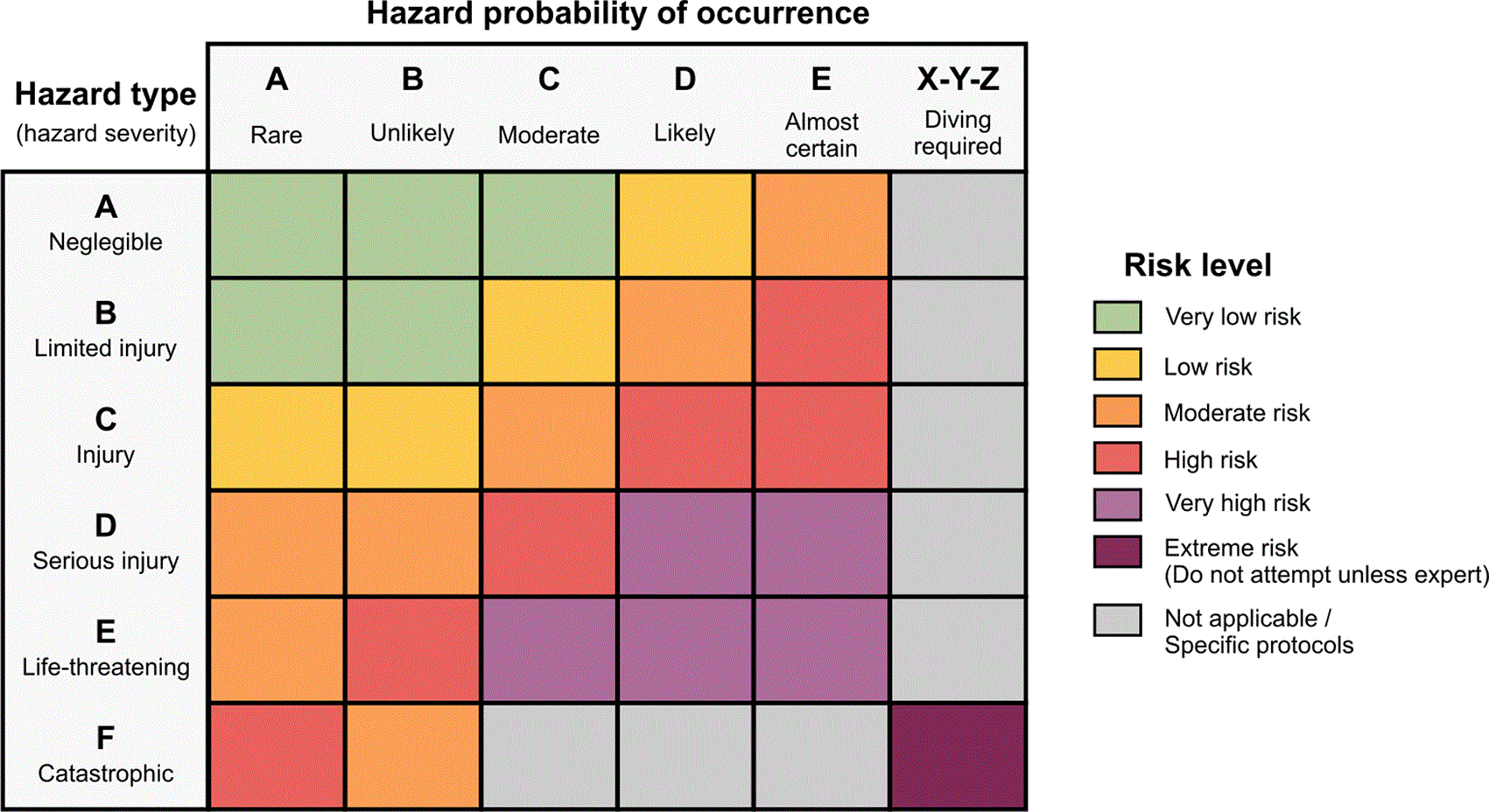
Figure 3. Site risk matrix derived from the CoEvolve Hazard Code.
Overall risk is determined by combining the severity associated with the hazard category and the estimated likelihood of occurrence. The resulting risk class defines the minimum operational requirements for sampling: Very Low Risk, no specific requirements beyond basic field training; Low Risk, specific hazards are present and appropriate personal protective equipment (PPE) is required; Moderate Risk, specific training and appropriate PPE are required; High Risk, specific training and technical equipment are required and sampling should not be attempted by unqualified personnel; Very High Risk, potentially life-threatening conditions requiring both specialized technical equipment and specific training; and Extreme Risk, sampling should not be attempted unless personnel are expert and appropriately certified. Activities requiring diving are treated as a dedicated operational category and require specific diving qualifications and procedures. See
Table 4 for the hazards coding system.
Microbial mat descriptor
Microbial mats observed at the sampling location are described using a three-character MatType code that records dominant color, structure, and putative metabolic association (
Table 4). The descriptor is assigned at the outlet or immediate discharge zone to preserve the spatial relationship between the mat and the sampled fluid and to minimize the influence of downstream mixing or alteration. The first character represents dominant color (e.g., green, yellow, white, red, black, multicolor, or absent), the second describes physical structure (e.g., filamentous, mucilaginous, encrusting, thin film, or multilayer), and the third records a putative metabolic association based on field observations (e.g., phototrophic, sulfidic, ferruginous, or undefined). The MatType code provides a standardized record of visually distinct microbial structures and characteristics that may be altered or lost during sample collection and processing. The inferred metabolic association is treated as a field observation rather than a functional assignment and is evaluated subsequently against geochemical and molecular data. Together with photographs and field notes, the descriptor facilitates comparison of mat characteristics across sampling locations and campaigns.
Core parameters: temperature, pH, ORP, DO, conductivity, salinity, TDS, and density
A core set of physicochemical parameters is measured at every sampling location and recorded in direct association with the corresponding CollectionID. Measurements are performed as close as possible in space and time to fluid collection, and the value corresponding to the sampled outlet is explicitly identified when multiple measurements are acquired across a seep system. The minimum dataset includes temperature, pH, oxidation–reduction potential (ORP), dissolved oxygen (DO; both concentration and percent saturation), specific conductivity, salinity, total dissolved solids (TDS), and density. Measurements are acquired using calibrated multiparameter probes (HANNA HI98494) or equivalent field instrumentation (e.g., YSI), with density measured separately using a field densimeter (
Table 3).
Measurements are preferably made directly at the outlet. When this is not possible, the fluid is transferred to the probe while minimizing the time between collection and measurement and limiting atmospheric exposure. For fluids at or above 55 °C, which exceed the operating temperature of the multiparameter probe used in our framework, an aliquot is collected in an airtight container without headspace and allowed to cool to 50–55 °C before measurement. The use of this procedure, including the temperature at which the measurement is made, is recorded in the field log. Measurements are acquired immediately before or after sample collection depending on outlet stability and accessibility. Where placement of sampling equipment may alter local conditions, measurements are repeated after installation to assess whether the sampled conditions have changed.
Where physicochemical gradients occur across a seep, measurements are made at multiple positions to characterize spatial variability and support selection of the least-mixed outlet. The measurement corresponding to the final sampling location is retained as the representative value for that CollectionID, while the additional measurements are preserved as contextual observations. All values are recorded with units, instrument identification, measurement location, and relevant information on acquisition conditions. Out-of-range values, failure to stabilize, or other measurement limitations are documented rather than discarded.
Calibration frequency and maintenance
Field sensors are calibrated during active sampling according to manufacturer specifications and recalibrated whenever drift is suspected, after transport, or following exposure to conditions that may affect sensor performance. Multiparameter-probe calibration includes at least a two-point pH calibration, conductivity standards, and dissolved oxygen calibration using air saturation or appropriate standards, where applicable. ORP sensors are checked against reference solutions. Calibration and electrode-storage solutions are included in the field kit and maintained according to manufacturer recommendations. Calibration events are recorded in the field log, including date and time, standards used, and any deviations from expected values. Sensors are rinsed with sample fluid between measurements to minimize carryover and are cleaned and stored according to manufacturer recommendations when not in use. Measurement limitations are documented together with the corresponding data. These include incomplete probe equilibration, measurements performed under constrained conditions such as cooled aliquots, unstable readings, values outside the calibrated or instrumental range, and measurements requiring averaging or other treatment. Recording these conditions allows measurement quality and uncertainty to be evaluated during subsequent interpretation rather than treating all field measurements as equally precise.
Field geochemistry
Total alkalinity
Total alkalinity is measured in the field as soon as possible after fluid collection to minimize changes associated with CO2 degassing and atmospheric exchange. Measurements are performed on freshly collected fluid, filtered or unfiltered depending on turbidity and analytical requirements, using a field titration kit (HANNA HI3811) following APHA Method 2320 (2320 alkalinity, 2017). Samples are titrated with hydrochloric acid of known normality using a bromophenol blue colorimetric endpoint, following the manufacturer protocol. Sample volume, acid normality, and titrant volume are recorded for calculation of total alkalinity. Replicate titrations are performed where sample volume and field conditions permit, particularly when the endpoint is uncertain.
Dissolved silica
Dissolved silica is measured in the field on 0.22 μm filtered fluid using a portable spectrophotometer (HANNA HI97770) and the corresponding colorimetric reagent kit. Reagents and reaction times follow the manufacturer protocol, and concentrations are determined using the instrument calibration. Measurements are performed as soon as possible after collection to limit changes associated with silica polymerization or precipitation. In high-temperature, silica-rich systems, samples are diluted immediately when required to prevent precipitation during cooling. Blanks and quality-control measurements are performed according to the analytical protocol, and dilution factors or observed interferences are recorded.
Total sulfide
Total sulfide is measured in the field whenever possible or preserved immediately for subsequent analysis. Field measurements are performed on freshly collected fluid with minimal atmospheric exposure using a portable spectrophotometer (HACH DR1900) and the methylene blue method (USEPA Method 8131). When immediate measurement is not possible, fluid aliquots are transferred directly into containers containing zinc acetate to preserve sulfide as ZnS. The amount of preservative is selected according to sample volume and expected sulfide concentration, and samples are mixed and sealed immediately after collection. The interval between collection and measurement or preservation is minimized and recorded. Samples in which oxidation, degassing, or incomplete preservation is suspected are flagged in the field log. Replicate measurements are performed where feasible, particularly in systems characterized by strong redox gradients or rapid sulfide turnover.
Dissolved iron (II)
Dissolved Fe (II) is measured in the field immediately after collection to minimize oxidation of Fe (II) to Fe (III). Measurements are performed on freshly collected 0.22 μm filtered fluid using the 1,10-phenanthroline colorimetric method (Method 8146), adapted from Standard Methods for the Examination of Water and Wastewater. The method has a working range of 0.02–3.00 mg/L Fe2+ and is applicable to freshwater, seawater, brines, and other high-ionic-strength waters. Reagent powder pillows are added according to the manufacturer protocol and, following the prescribed reaction time, absorbance is measured using a portable spectrophotometer. Samples exceeding the analytical range are diluted and reanalyzed. Blanks, dilution factors, interferences, and other deviations from the standard procedure are recorded in the field log.
Field data logging and QA/QC
Field log and metadata structure
The field log is the central operational record for each sampling event and links site context, field observations and measurements, collected samples, and associated datasets within a single structured record (
Figure 4). It is completed at the time of sampling in paper or digital format and indexed to the corresponding ExpID, SiteID, and CollectionID.
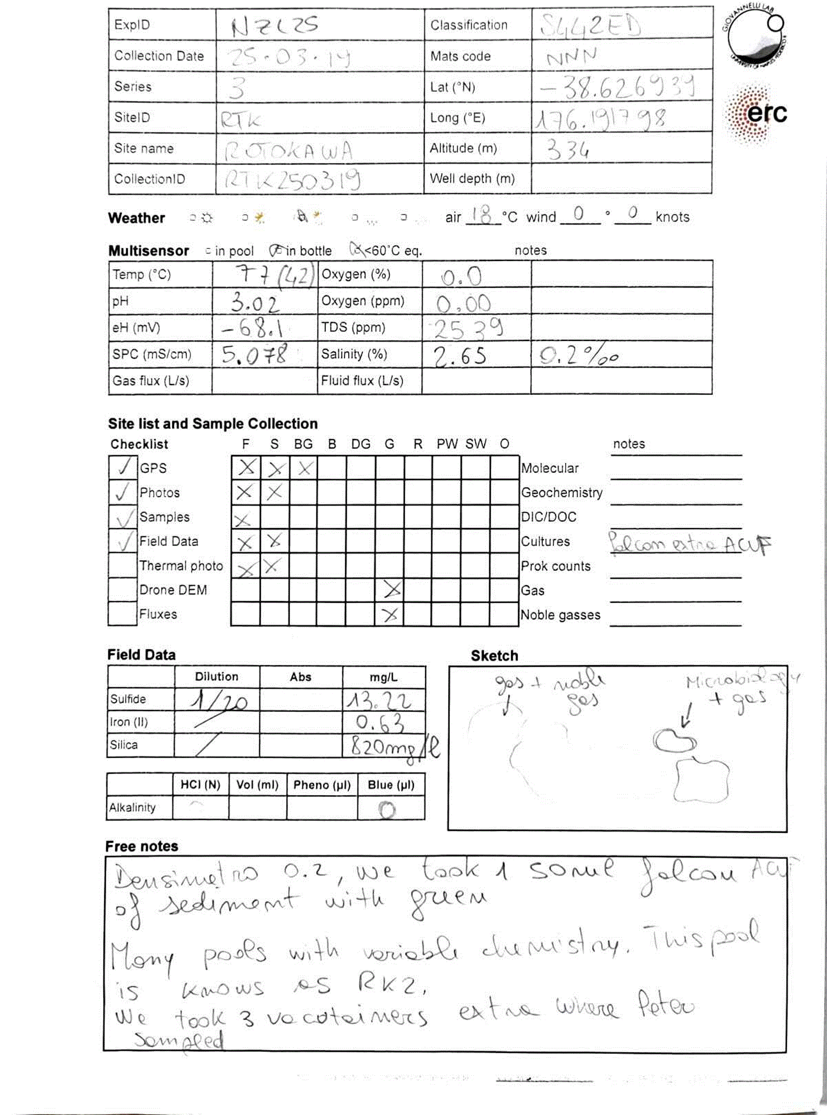
Figure 4. Example of a completed field log sheet used in the CoEvolve field sampling framework.
Standardized field logs ensure consistent recording of sample metadata, in situ measurements, sampling activities, and observational notes, providing traceable documentation from sample collection to downstream analyses. Log sheets are completed in pencil to prevent loss of information if the paper becomes wet or ink bleeds, and are photographed immediately after completion to create a digital backup.
For each collection event, the field log records geographic coordinates (WGS84), altitude, date and time, environmental conditions, site and outlet descriptions, core physicochemical parameters, field geochemistry, and fluid and gas flux measurements where available. A structured checklist records the matrices and analytical fractions collected, together with associated photographs, thermal images, GPS records, and drone-derived datasets. Dedicated fields are provided for sketches, deviations from the standard sampling procedure, disturbances during sampling, and other observations that cannot be captured through predefined fields (Supplementary Data 1).
The field log also records completion of the planned sampling series. SampleIDs are assigned to each collected matrix, and analytical fractions and containers are recorded using their corresponding operational codes. Fractions that could not be collected, measurements that failed or were outside instrumental range, and deviations from standard preservation or storage procedures are explicitly recorded rather than left as missing entries. This distinction allows true missing data to be separated from samples or measurements that were intentionally omitted or could not be obtained under field conditions.
Minimum metadata required for each sampling event include ExpID, SiteID, CollectionID, SampleID, geographic coordinates, altitude, date and time, sample matrix, preservation and storage conditions, operator or sampling team, and the core physicochemical measurements. Contextual information including host lithology, discharge characteristics, hydrological conditions, outlet geometry, and sampling disturbance is recorded where relevant. Metadata are entered or transferred to the project database as soon as practical after field collection, while field records remain available as the primary record of the sampling event.
Identifier errors are handled conservatively to preserve traceability. Errors detected before identifiers propagate into analytical datasets are corrected directly and the incorrect identifier retired. Where an incorrect identifier has already entered analytical workflows, databases, or external records, the correction is documented and an explicit mapping between the original and corrected identifiers is retained. Original identifiers that have propagated beyond the field record are not silently deleted or reassigned.
Contamination assessment and subsurface confidence
Multi-proxy scoring framework
The relative contribution of subsurface and surface signals is evaluated after collection using the multi-proxy framework introduced above and formalized in the decision matrix in
Table 5. The framework integrates independent geochemical, physical, and biological lines of evidence rather than relying on any single indicator of subsurface origin or surface influence. Each available proxy is assigned a score of +1 when it supports a predominantly subsurface signal, 0 when the evidence is intermediate, ambiguous, or does not discriminate between subsurface and surface influence, and − 1 when it supports stronger surface influence. Proxies that were not measured, failed quality control, or cannot be interpreted for a particular geological setting are treated as unavailable and are not assigned a score.
Table 5. Decision matrix for evaluating subsurface versus surface influence in samples from deeply-sourced seeps.
Each interpretable geochemical, physical, or biological proxy is scored as +1 (subsurface-dominated), 0 (intermediate or ambiguous), or − 1 (surface-dominated). The normalized subsurface confidence score ranges from −1 to +1 and defines five classes: subsurface-dominated (+0.6 to +1.0), likely subsurface (+0.2 to <+0.6), mixed or unresolved (> − 0.2 to <+0.2), surface-influenced (> − 0.6 to −0.2), and surface-dominated (−1.0 to −0.6). At least five complementary proxies are recommended; formal classification requires a minimum of three interpretable proxies spanning at least two independent evidence domains. Proxy coverage should be reported with the score (e.g., 5/7 proxies evaluated). The score represents confidence in subsurface signal preservation rather than a quantitative estimate of mixing.
| Proxy category | Indicator | Measurement | Subsurface-dominated signal (Score = +1) | Mixed signal (Score = 0) | Surface-dominated signal (Score = −1) | Notes/limitations |
|---|
| Noble gases | 4He/20Ne ratio | MS | Significantly above atmospheric values (>10) | Slightly above atmospheric values (3–10) | Near atmospheric values (<3) | Strong indicator of air contamination or shallow mixing |
| Noble isotopes | 3He/4He | MS | Significantly different from atmospheric (<0.5 or > 2) | Intermediate (between 0.5 and 2) | Atmospheric-like (~1) | Crustal vs. mantle contribution to volatiles |
| Biological reactive gases | H2, CH4 | GC | Elevated reduced gases | Moderate | Low/absent | Sensitive to oxidation |
| Gases | N2–He–Ar systematics | GC | Position on ternary plot and high He/Ar or N2/He | Position on ternary plot and intermediate He/Ar or N2/He | Position on ternary plot and N2/Ar of 40–80 | Separating crustal, mantle and atmospheric contributions |
| Gases | 40Ar/36Ar | GC-MS
| High (> 350) | Intermediate (350–300) | Low (~295) | Strong indicator of air contamination or shallow mixing |
| Dissolved oxygen | DO | Probe | Near zero/anoxic | Low (20–50%) | High (>50) | Rapid equilibration possible |
| Carbon isotopes | δ13C-DIC/CO2 | IRMS | Deep/abiotic signature (−5–0 ‰) | Intermediate (biogenic or 0 ‰) | Atmospheric (−8 ‰) | Overlapping ranges, difficult to evaluate in isolation |
| Salinity/TDS | Conductivity | Probe | High/brine signature | Moderate | Low/meteoric | Evaporation can bias, seawater recharge alters interpretation |
| Redox species | Sulfide, Fe (II) | Colorimetric | High reduced species | Moderate | Oxidized forms dominate | Rapid oxidation post-sampling
|
| Aqueous major ion species | Cl−–SO42−–HCO3- | IC | Deep chloride, thermal waters | Acid-sulfate waters,intermediate waters, steam-heated waters | Meteoric and/or peripheral waters | Position on ternary plot and piper plot relative to known surface samples. Depends on geology |
| Aqueous major ion species | Maturation plot (K + Na)–Mg–Ca | IC | Mature or partially mature waters | Immature waters | Proximity to the Mg corner | Position on Giggenbach maturation ternary plot. Depends on geology |
| Water isotopes | δD2, δ18O of H2O | IRMS | Overlap with andesitic or magmatic waters | Deviation from local meteoric line | Near the local meteoric line or known surface samples | Influenced also by evaporation and boiling |
| Microbial community | Taxonomy | Sequencing | Anaerobes, chemolithotrophs | Mixed assemblage | Phototrophs, aerobes | Requires context |
| Functional genes | Metabolic pathways | Metagenomics | Hydrogenases, sulfur reduction, methanogenesis | Mixed | Photosynthesis, aerobic respiration | Dependent on annotation quality |
| Pigments | Chlorophyll, carotenoids | Spectroscopy | Absent | Trace | Abundant | Persistence after death possible |
| Biomass | Cell counts | Microscopy/flow cytometry | Low–moderate | Moderate | High | Surface blooms bias counts |
| Background similarity | Community overlap | Beta-diversity
| Distinct from background | Partial overlap | Strong similarity | Requires proper BG sample |
Because the number of informative proxies may differ among samples, the cumulative score is normalized by the number of proxies evaluated:
where sᵢ is the score assigned to proxy i and n is the number of proxies considered interpretable for that sample. S_norm ranges from −1 to +1, with increasingly positive values indicating greater support for preservation of a subsurface signal and increasingly negative values indicating stronger surface influence.
The normalized score is interpreted using five classes: +0.6 to +1.0, subsurface-dominated with high confidence; +0.2 to <+0.6, likely subsurface with evidence of mixing; > − 0.2 to <+0.2, mixed or unresolved; > − 0.6 to −0.2, surface-influenced; and − 1.0 to −0.6, surface-dominated with high confidence. Classification requires a minimum of three interpretable proxies representing at least two independent evidence domains, for example geochemical and biological evidence. Scores derived from fewer proxies may be reported descriptively but are considered provisional and are not assigned a formal confidence class.
The normalized score is always reported together with proxy coverage (e.g., S_norm = 0.60; 5/7 proxies evaluated), allowing the strength and completeness of the underlying evidence to remain explicit. Where relevant, the individual proxy scores should also be retained in the dataset so that identical normalized scores arising from different combinations of evidence can be distinguished.
In the present implementation, all proxies contribute equally to the normalized score. This is a deliberate simplification rather than an assumption that all proxies have equivalent diagnostic power. Their informativeness is expected to vary among geological settings, and some proxies may be partially correlated. Developing differential weights would require independent calibration, assessment of covariance among proxies, and validation across sufficiently diverse and independently characterized seep systems. Until such validation is available, equal weighting provides a transparent and reproducible first-order framework while allowing the contribution of individual proxies to remain visible.
The resulting classification represents an evidence-based assessment of subsurface signal preservation rather than a quantitative estimate of the fraction of surface contamination. It is therefore not used as an automatic criterion for sample inclusion or exclusion. Mixed and surface-influenced samples remain informative where transformations during fluid ascent, discharge, or near-surface residence are relevant to the scientific question.
Field blanks and procedural controls
Field blanks and procedural controls are included according to the analytical workflow, particularly for molecular analyses and procedures involving reusable sampling equipment. Equipment blanks are used to assess contamination introduced by sampling lines, pumps, connectors, or other reusable components, while filtration and processing blanks assess contamination introduced during filtration, handling, preservation, or other field procedures. Sterile water or an appropriate analytical-grade solution is processed through the same equipment and handling steps as the corresponding environmental sample, as closely as practical. Blanks and controls are linked to the relevant CollectionID and recorded within the same metadata architecture as environmental samples, but are identified explicitly as controls rather than environmental sample types. Metadata record the type of control, equipment and materials involved, preparation conditions, and the sampling or processing steps represented. Where appropriate, controls are carried through the complete downstream analytical workflow together with environmental samples, allowing contamination introduced during field collection and processing to be identified and distinguished from signals present in the original sample.
Limitations of the approach and sources of bias
Surface mixing
Surface mixing remains an intrinsic limitation of using deeply-sourced seeps as windows into subsurface processes. Fluids and associated materials may be modified during ascent and discharge through cooling, degassing, oxidation, mixing with shallow or surface waters, atmospheric exchange, and biological activity. The sampling protocol minimizes these effects where possible, while the multi-proxy scoring framework provides an explicit assessment of the relative preservation of subsurface versus surface signals (
Table 5). However, the normalized score represents a measure of confidence based on the available evidence rather than a quantitative estimate of the proportion of subsurface-derived material in a sample. Samples classified as mixed or surface-influenced are therefore not necessarily unsuitable for analysis, but inferences about subsurface processes must account for the degree and nature of the inferred overprint. In some settings, these samples may instead provide information on transformations occurring during fluid ascent, discharge, and near-surface mixing.
Temporal variability
Deeply-sourced seeps are temporally dynamic. Discharge location, flow rate, gas flux, temperature, and fluid composition can vary over timescales ranging from hours to years in response to tides, precipitation and recharge, seasonal variability, seismic activity, and volcanic or hydrothermal processes. Each CollectionID therefore represents the state of a seep at a specific sampling event rather than a temporally invariant characterization of the site. Repeated sampling allows this variability to be quantified, but many sites are sampled only once because of logistical constraints. In these cases, temporal representativeness cannot be established from the sample itself and interpretation relies on the environmental and hydrological context recorded at collection. Temporal variability may also alter the degree of surface mixing and therefore the subsurface confidence assigned to different sampling events at the same site.
Accessibility bias
The seep systems sampled using this framework constitute a non-random subset of subsurface discharge environments. Site selection is constrained by prior knowledge, detectability, physical accessibility, permitting, safety, and logistical feasibility. Remote, hazardous, weakly expressed, or highly diffuse systems are consequently less likely to be sampled. Selection bias can also occur within individual seep systems, because focused, stable, or readily accessible outlets are more amenable to complete synoptic sampling than diffuse, transient, or inaccessible discharge. These constraints may systematically favor particular types of seep systems and therefore limit extrapolation from sampled sites to regional or global subsurface environments. The geological-gradient sampling strategy provides a structured basis for comparison across sites but does not eliminate this bias. Accessibility and selection constraints should therefore be considered explicitly when interpreting the prevalence or distribution of biological and geochemical characteristics observed across the resulting datasets.
Operator variability
Some elements of field sampling necessarily involve operator judgment, including identification of the most representative outlet, placement of sampling equipment, assessment of discharge structure, and selection of appropriate background samples. Standardized procedures, quantitative field measurements, structured metadata, and explicit decision criteria reduce this variability but cannot eliminate it, particularly in heterogeneous or poorly defined seep systems. Consistency across operators and campaigns is improved through training, shared field protocols, calibration exercises, and reference material documenting representative sampling situations. Decisions that depart from the standard workflow, ambiguous sampling conditions, and disturbances introduced during collection are recorded in the field log. Residual operator-dependent variability should nevertheless be considered when comparing samples collected by different teams or under substantially different field conditions.
Data management and sharing
FAIR principles
Field and analytical data are structured around the ExpID, SiteID, CollectionID, and SampleID hierarchy, which provides the common reference linking samples, measurements, metadata, and analytical outputs across the workflow. Metadata are generated at the time of sampling and maintained as part of the core dataset rather than reconstructed during data publication. This structure is designed to support implementation of the FAIR principles of findability, accessibility, interoperability, and reusability (Wilkinson et al., 2016). Findability and accessibility are supported through deposition in public repositories and the assignment of persistent identifiers to released datasets. Interoperability is facilitated through structured metadata, standardized formats and vocabularies, and persistent mapping among field and analytical identifiers. Reusability is supported by preserving sampling conditions, analytical context, QA/QC information, and relationships among samples and derived datasets. A dedicated R package for automated QA/QC and curation of the resulting datasets is currently under development.
Data and repository architecture
Field data and metadata are integrated into CoEvolveDB (www.coevolvedb.org), a structured project database that maintains relationships among sampling events, physical samples, field measurements, analytical results, and contextual information. The database is organized around the identifier hierarchy and supports integration of data generated across different expeditions, analytical workflows, and projects. Protocols, field templates, controlled vocabularies, data-processing scripts, and associated code are maintained in a version-controlled GitHub repository (Chen et al., 2025). The repository contains the actively maintained version of the field framework and associated computational tools. Stable versions of datasets, protocols, and supporting documentation are archived through Zenodo and assigned persistent DOIs. Released materials are cross-referenced through the identifier system so that field records, analytical datasets, code, and documentation can be traced to the corresponding sampling events and samples.
Domain-specific data deposition
Analytical datasets are additionally deposited in appropriate domain-specific repositories. Geochemical data are deposited in repositories such as EarthChem where compatible with project and data requirements, with CollectionID and SampleID retained in the submitted metadata to preserve links to the corresponding field records and complementary datasets.
Sequence and other molecular data are deposited in established nucleotide sequence repositories, including ENA and NCBI, with repository accession numbers mapped to the corresponding SampleIDs. Cross-references among project databases, domain repositories, and archived dataset releases are retained in the metadata, allowing geochemical, biological, and contextual information generated from the same sampling event to be integrated after deposition.
Deposited datasets include the metadata required to reconstruct sampling context and, where available, the individual proxy scores, normalized subsurface confidence score, and proxy coverage used in the contamination-assessment framework (
Table 5). This preserves the evidence underlying the classification rather than reporting only the resulting confidence class.
Field reports as reproducibility infrastructure
Each field campaign is accompanied by an expedition or field report that preserves contextual and operational information not readily represented in tabular datasets. The use of expedition reports as part of the scientific record has a long history in oceanographic, scientific drilling, and other large-scale Earth science programs, where they provide the link between field operations and the samples and observations generated during a campaign (Bastoni et al., 2024; Giovannelli et al., 2024; Montemagno et al., 2026). Field reports produced within this framework typically document campaign objectives, regional geological context, sampling rationale and chronology, maps and access routes, site and outlet descriptions, photographs, environmental and hydrological conditions, and logistical or site-specific limitations. Where available, they also reference thermal and drone imagery, geospatial products, preliminary field measurements, and associated KMZ or other spatial files maintained with the campaign data.
These reports are treated as part of the reproducibility infrastructure rather than solely as expedition summaries. They preserve observations and operational context that may be simplified or lost when field records are converted into analytical datasets and allow subsequent users to reconstruct how, where, and under which conditions samples were obtained. This contextual record is particularly relevant for deeply-sourced seeps, where outlet geometry, discharge conditions, weather, hydrological state, seasonality, and local disturbance can affect the interpretation of samples and measurements.
Conclusions
The framework presented here provides a standardized approach for sampling deeply-sourced seep systems, integrating field strategy, synoptic and co-located sampling, analytical partitioning, sample identification, and data management within a common operational workflow. It was developed to investigate geosphere–biosphere interactions using seeps as accessible expressions of subsurface processes, while preserving the geological, spatial, and temporal context required for interpretation.
The framework combines predefined sampling units, hierarchical identifiers, structured metadata, and field QA/QC to maintain traceability from collection through analysis and data deposition. Surface modification, an unavoidable feature of seep systems, is addressed explicitly through a multi-proxy subsurface confidence assessment rather than through an assumption of sample purity. This allows samples to be interpreted along a continuum from subsurface-dominated to surface-dominated conditions while retaining mixed systems as potentially informative components of the dataset.
Standardization does not imply that identical samples or measurements can be collected at every site. Rather, the framework provides a common structure within which site-specific constraints, incomplete sampling, and deviations from the standard workflow can be documented without losing comparability among sampling events and campaigns. This structure supports integration of observations across geological settings and over time, providing a reproducible basis for investigating how geological processes structure subsurface microbial ecosystems.
Although developed specifically for the study of deeply-sourced seeps and subsurface geosphere–biosphere interactions, much of the framework is transferable to other field-based research requiring synoptic, co-located sampling across multiple matrices, campaigns, laboratories, and environmental settings. The individual components can therefore be adapted to different scientific questions while retaining the principles of traceability, contextual integrity, and interoperability that underpin the workflow.
Ethics and consent
Ethical approval and consent were not required.
AI contribution statement
Artificial intelligence (ChatGPT, OpenAI) was used during manuscript preparation solely for language refinement, improvement of readability, and correction of grammatical errors. The authors reviewed and edited all AI-assisted text corrections and retain full responsibility for the content of the manuscript.