Description
The study area consists of three seismic domains: (1) a shallow (≤ 3.0 seconds TWT), wedge-shaped domain of highly disrupted, tightly curving, moderate- to low-amplitude reflections in the southwest, (2) a shallow (≤ 2.5 seconds TWT) domain of northeast-prograding, continuous, high- and low-amplitude reflections in the northeast, and (3) a deep, lower domain of moderate to high-amplitude reflections bounded from the southwestern domain by a major, gently SSW-dipping disruption surface (labelled “ST” in
Figure 3a–d) and from the northeastern domain by a prominent, positive, high-amplitude, truncating reflection (light green horizon in
Figure 3a–h).
Southwestern domain
The up to 3.0-second-thick (TWT), shallow (≤ 3.0 seconds deep; TWT), c. 30 km wide southwestern seismic domain displays a wedge geometry, which thins down gradually and pinches out to the northeast (
Figure 3a–d). Thus, discontinuous, moderate- to low-amplitude, curving up and down reflections of the southwestern domain gradually transition into gently undulating, dominantly northward-prograding, high- to low-amplitude, continuous reflections of the northeastern domain. The transition occurs first at a depth of ca. 2.0–2.8 (TWT) and gradually to shallower levels (
Figure 3a–d). Within this wedge-shaped domain, seismic reflections show a relatively higher amplitude at depth ≥ 0.5 second (TWT) in the southwesternmost portion of the southwestern domain and gradually deeper in a step-like fashion northwards (e.g., blue and light green horizons in
Figure 3a–d and
Figure 4).
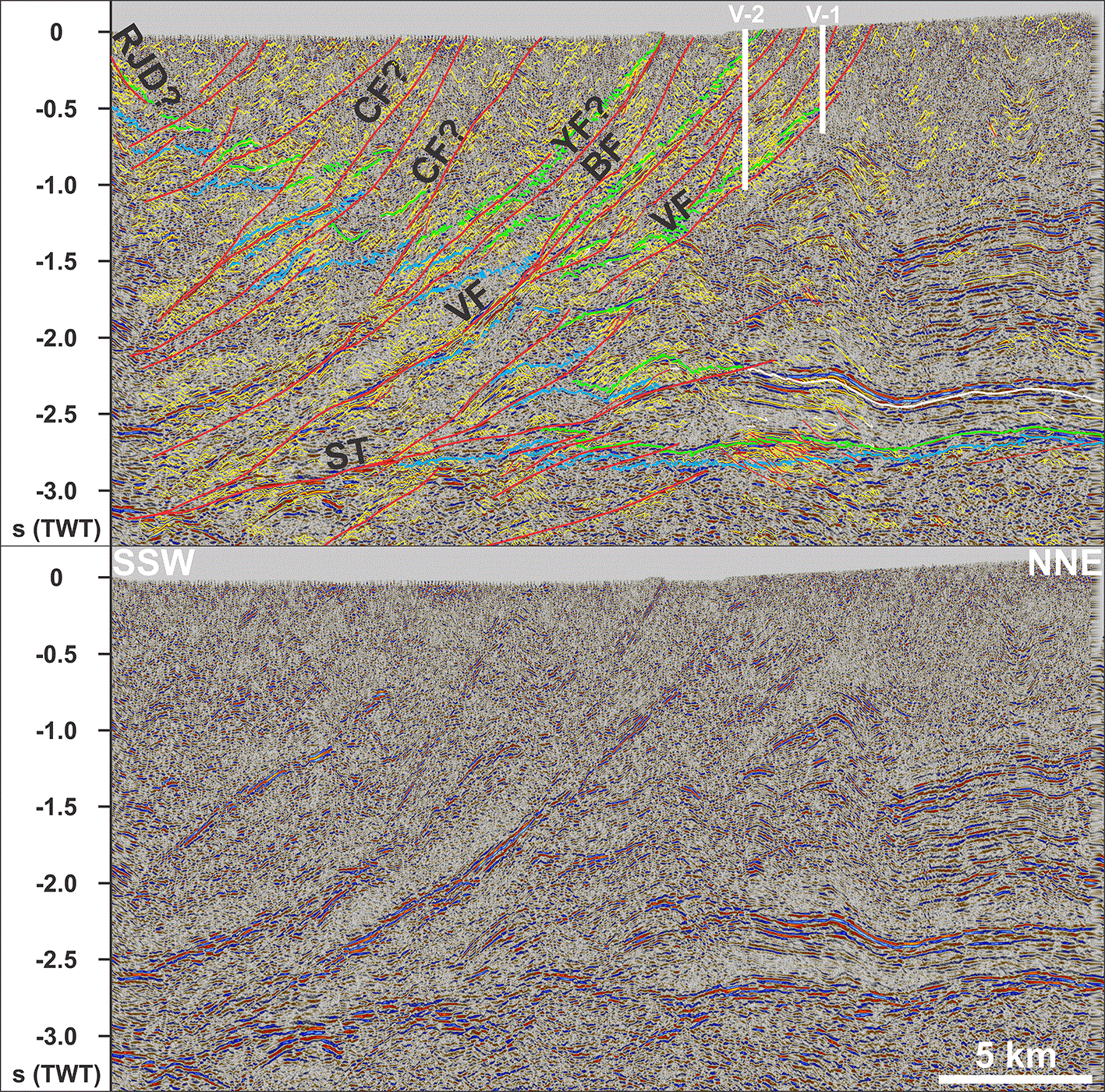
Figure 4. Interpreted (up) and uninterpreted (down) zoom in the Tierra del Fuego fold-and-thrust belt in the southwestern part of seismic transect PR-1 showing the overall imbricate geometry of thrust faults (e.g., Colo-Colo, Yartou, Bahia Bell, and Vicuña fault zones), which flatten at depth into the sole thrust (SF).
Notice how the Yartou and Vicuña faults parallel and detach major stratigraphic boundaries (light green Mid-Cretaceous unconformity reflection) observed both in outcrops and in nearby wellbores (V-1 and V-2; Zanella et al., 2014), thus suggesting that these faults initiated as bedding-parallel décollements at depth. Also notice the transition of tightly deformed Paleozoic–Mesozoic strata in the Tierra del Fuego fold-and-thrust belt in the hanging wall of the Vicuña fault zone in the southwest to more mildly deformed Cenozoic strata in the northeast. See location and legend in
Figure 3a. Abbreviations: BF: Bahia Bell fault zone; CF: Colo-Colo fault zone; RJD: Río Jackson detachment; ST: Sole thrust; VF: Vicuña fault zone; V-1: Vicuña 1 wellbore; V-2: Vicuña 2 wellbore; YF: Yartou fault zone.
The southwestern domain is truncated by major, tens of km wide, 0.5–3.0 seconds (TWT) thick, steeply to moderately SSW-dipping, listric disruption surfaces (
Figure 3a–d and
Figure 4). Most of these disruption surfaces are characterized by relatively planar, high-amplitude reflections, which contrast with the dominantly highly discontinuous, moderate- to low-amplitude, curving up and down reflections of the southwestern domain (
Figure 3a–d and
Figure 4). Offset across these major disruption surfaces is typically ≥ 5 km top-northeast (
Figure 3a–d and
Figure 4). At a depth of 2.5–3.0 seconds (TWT), most major disruption surfaces flatten into and merge with a gently SSW-dipping disruption surface at the boundary with the lower domain (
Figure 3a–d and
Figure 4). Minor, up to a few km wide, steeply to gently SSW-dipping, listric disruption surfaces also occur and typically display tens to hundreds of meters wide, reverse (top-northeast) offsets (
Figure 5a–e). In places, they flatten into major disruption surfaces and/or one another downwards, resulting in fan-shaped clusters (
Figure 3a–d,
Figure 4,
Figure 5a–e).
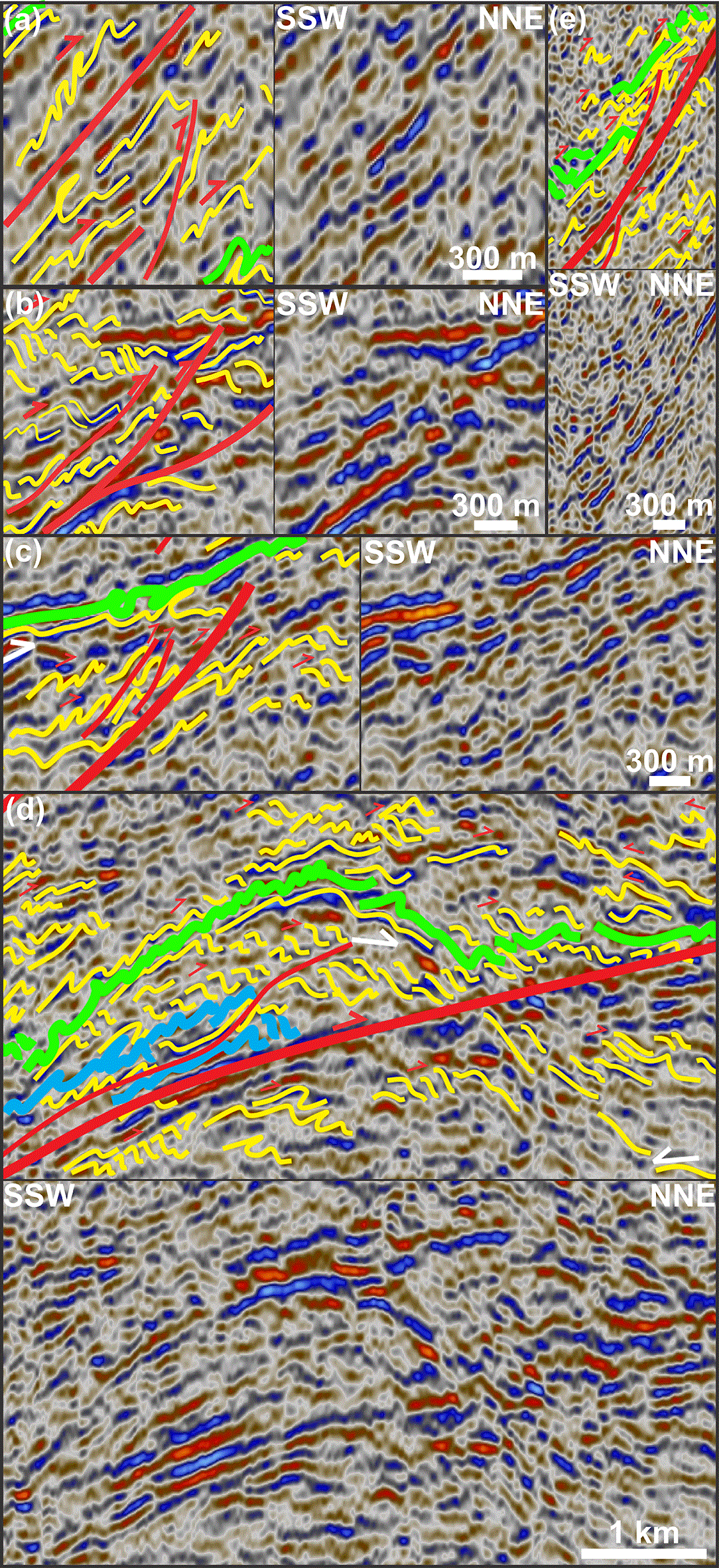
Figure 5. (a) Interpreted (left) and uninterpreted (right) zoom in potentially soft-linked top-NNE thrust faults flanked by NNE-verging, close to isoclinal, inclined to recumbent folds along the Colo-Colo fault zone.
(b) Interpreted (left) and uninterpreted (right) zoom in possibly mylonitic thrust fault splays of the Colo-Colo fault zone associated with NNE-verging folds, and tight, Z-shaped, forward-dipping duplexes. (c) Interpreted (left) and uninterpreted (right) zoom in thrust fault splays of the Vicuña fault zone showing NNE-verging, inclined to isoclinal folds, possible early-stage, top-NNE duplexes consisting of Z-shaped horses, and potential toplap reflection terminations (white half arrow) below the Mid-Cretaceous unconformity (light green lines). (d) Interpreted (up) and uninterpreted (down) zoom in the sole thrust (thick red line) showing NNE-verging folds, an antiformal thrust stack, and top-NNE duplexes and décollement–detachment faults with ramp-flat geometries soling into the sole thrust. (e) Interpreted (up) and uninterpreted (down) zoom in a shallow segment possibly of the Yartou fault zone associated with NNE-verging, inclined to overturned folds and minor thrust imbricates, and potential duplexing of the Mid-Cretaceous unconformity reflection (light green lines) along the main, likely mylonitic, fault surface (thick red line). See location and legend in
Figure 3a.
Moderate- to low-amplitude curving reflections in the southwestern domain show both open to close, in places (in the southwestern domain) chevron-like (i.e., tight, triangular, Λ- or V-shaped), symmetric geometries with wavelengths of a few kilometers and close up to isoclinal, upright to overturned, asymmetric geometries with associated wavelengths of a few hundred meters to a kilometer (
Figure 6,
Figure 7a–b,
Figure 8a–d, and
Figure 9a–c). Asymmetric reflections typically consist of a relatively gently–moderately dipping long edge and a steeply (generally oppositely) dipping narrow edge (
Figure 7a–b and
Figure 8a–d). While asymmetric reflections show both SSW- (i.e., a gently NNE-dipping, long edge in the northeast and a steeply SSW-dipping narrow edge in the southwest) and NNE-verging geometries (i.e., a gently SSW-dipping, long edge in the southwest and a steeply NNE-dipping narrow edge in the northeast), the latter type dominates the northeastern flank of symmetric curving reflections and along major SSW-dipping disruption surfaces (
Figure 3a–d,
Figure 4,
Figure 6,
Figure 7a–b,
Figure 7a–b,
Figure 8a–d, and
Figure 10). Asymmetric reflections in the southwestern domain also commonly occur as stacks (
Figure 4,
Figure 5b–e, and
Figure 8c–d). In places, these stacks include dense sets of dominantly Z-shaped asymmetric reflections, especially along major disruption surfaces (Figure 5b–e and
Figure 8c–d).
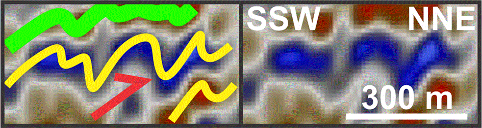
Figure 6. Interpreted (left) and uninterpreted (right) zoom in upright symmetrical folds transitioning to tight, NNE-verging asymmetric folds along the Vicuña fault zone in the Tierra del Fuego fold-and-thrust belt.
See location and legend in
Figure 3a.
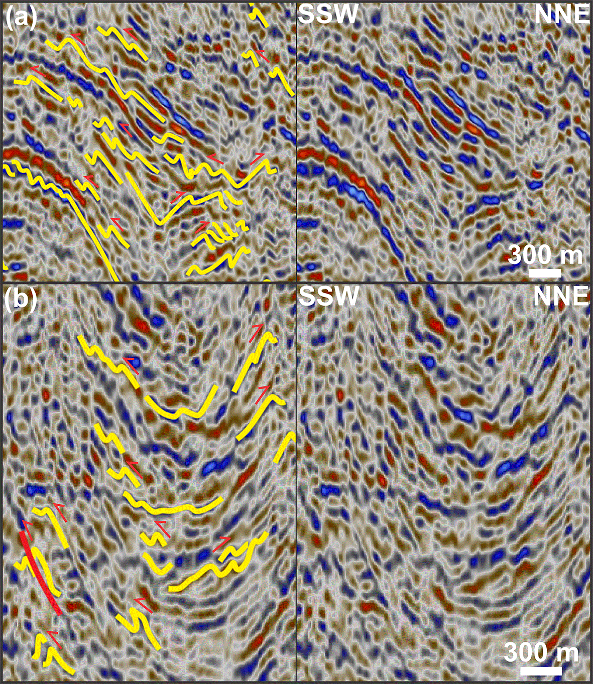
Figure 7. (a) Interpreted (left) and uninterpreted (right) zoom in hundred-meter- to km-scale, SSW-verging asymmetric folds showing opposite vergence to the dominant top-NNE transport direction in the Tierra del Fuego fold-and-thrust belt.
The folds are located on the northern limb of a several km wide, open, upright anticline and likely correspond to parasitic folds. (b) Interpreted (left) and uninterpreted (right) zoom in asymmetric parasitic folds showing opposite vergence on opposite limbs of a several km wide open, upright syncline, thus suggesting overall limited tectonic transport. See location and legend in
Figure 3a.
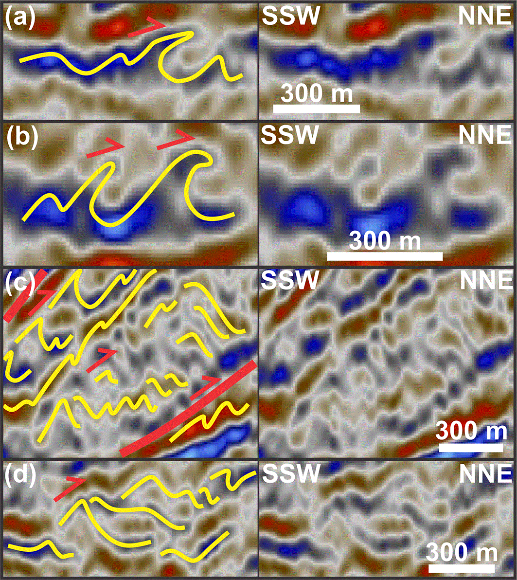
Figure 8. (a) Interpreted (left) and uninterpreted (right) zoom in a hundred-meter-scale, NNE-verging, recumbent, isoclinal fold in the Tierra del Fuego fold-and-thrust belt.
(b) Interpreted (left) and uninterpreted (right) zoom in hundred-meter-scale, NNE-verging, overturned to recumbent folds in the Tierra del Fuego fold-and-thrust belt. (c) Interpreted (left) and uninterpreted (right) zoom in hundreds of meters wide, NNE-verging asymmetric folds transitioning to top-NNE duplexes. Notice how the packages consisting of relatively low-amplitude reflections characterizing duplex horses are overlain and underlain by more mildly deformed units characterized by relatively continuous, high-amplitude reflections deformed into inclined to overturned asymmetric folds. This illustrates strain partitioning and decoupling between intensely deformed, weak volcanosedimentary units and more mildly deformed, competent units, i.e., initiation of bedding-parallel décollements–detachments. (d) Interpreted (left) and uninterpreted (right) zoom in NNE-verging asymmetric folds transitioning into Z-shaped, top-NNE duplex horses. See location and legend in
Figure 3a.
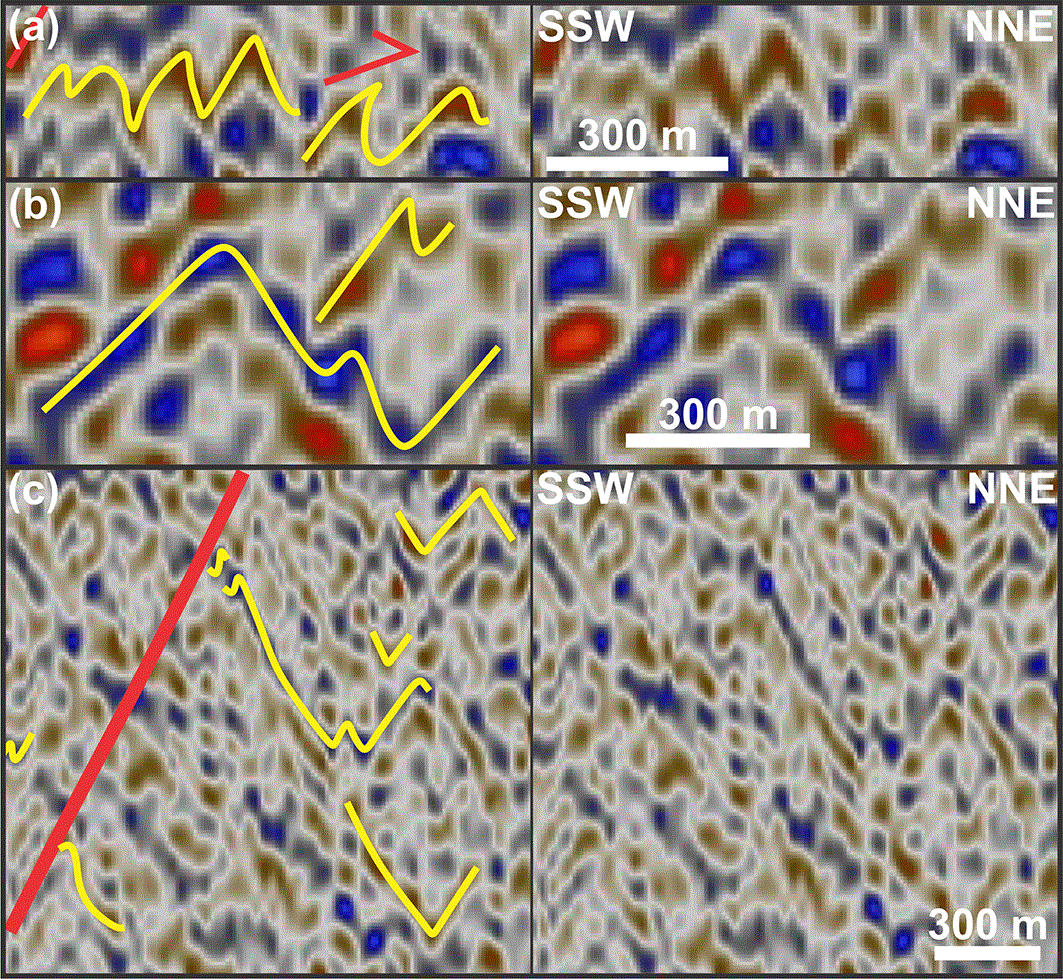
Figure 9. (a) Interpreted (left) and uninterpreted (right) zoom in close to tight, upright shallow chevron folds transitioning to NNE-verging asymmetric folds in Upper Cretaceous rocks in the Tierra del Fuego fold-and-thrust belt.
(b) Interpreted (left) and uninterpreted (right) zoom in hundreds of meters wide, upright, open chevron folds with a potential, SSW-verging, parasitic fold. (c) Interpreted (left) and uninterpreted (right) zoom in shallow, hundred-meter-scale, upright, open chevron folds in Upper Cretaceous rocks in the Tierra del Fuego fold-and-thrust belt. See location and legend in
Figure 3a.
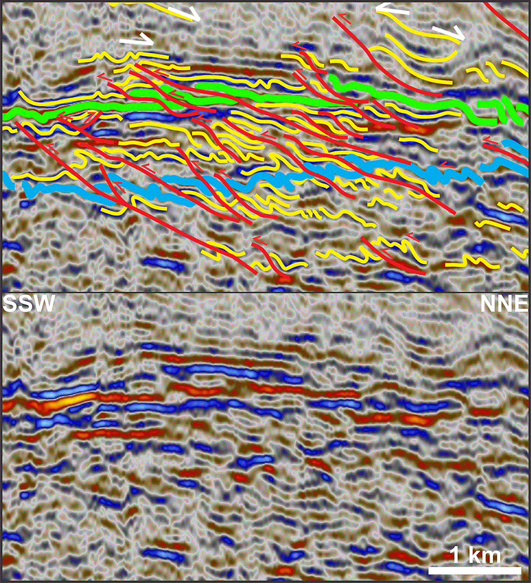
Figure 10. Interpreted (up) and uninterpreted (down) zoom in hundred-meter-scale offsets of major stratigraphic boundaries (blue and light green lines) by a cluster of minor, top-SSW, low-angle thrusts showing ramp–flat, imbricate, and splaying geometries with potential floor, roof, and link thrusts within an early-stage, backward-dipping duplex structure in the footwall of the sold thrust.
The thrusts are associated with inclined to overturned, open to isoclinal folds. Notice the dominant SSW-verging character of the folds and thrusts, i.e., opposite the dominant tectonic transport direction in the Tierra del Fuego fold-and-thrust belt, which suggests limited tectonic transport. See location and legend in
Figure 3a.
Lower domain
The upper part of the lower domain is characterized by 10–25 km wide, ca. 1.0–1.5 seconds (TWT) thick, undulating, U-shaped seismic packages consisting of alternating low- and high-amplitude reflections (
Figure 3a–h). These packages consist dominantly of asymmetric (locally π-shaped), curving reflections and are thickest at the center of the U-shaped troughs. For example, the thin (typically 0.1 second thick; TWT) uppermost package of the lower domain (package between dark green and light green horizons in
Figure 3a–h,
Figure 11,
Figure 12,
Figure 13, and
Figure 14a–e) thickens up to 0.2–0.3 second (TWT) and the areas where this succession is thickest are bounded on either side by minor, low-angle to subhorizontal disruption surfaces dipping towards the thickened area and showing hundreds of meters top-NNE and top-SSW reverse offsets (
Figure 3a–b and e–h,
Figure 11,
Figure 12,
Figure 14e,
Figure 15, and
Figure 16). Comparably to the southwestern domain, asymmetric reflections in the lower domain also occur as stacks, but also display S-shaped geometries in places, e.g., on the southwestern flanks of U-shaped seismic packages (
Figure 3a–b and e–h,
Figure 11,
Figure 12,
Figure 17a–i, and
Figure 18a–b).
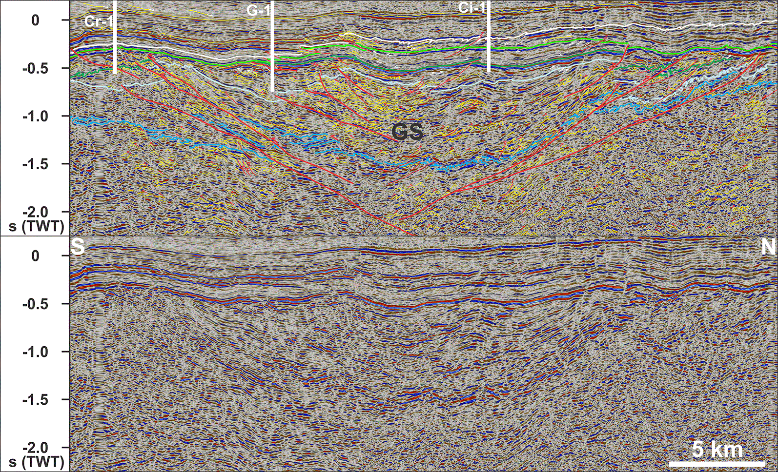
Figure 11. Interpreted (up) and uninterpreted (down) zoom in the U-shaped, tens of km wide, upright, open Gaviota syncline.
The syncline consists of Jurassic–Lower Cretaceous volcanosedimentary rocks deformed into hundreds of meters asymmetric folds and thrusts showing opposite vergence on either flank of the syncline (i.e., NNE-verging in the northern limb and SSW-verging in the southern limb of the syncline), thus indicating limited tectonic transport and displacement. Overlying Upper Cretaceous–Cenozoic sedimentary rocks are significantly less intensely deformed, which suggests a syn- to post-tectonic deposition. In contrast, the thickening of Lower Cretaceous succession towards the center of the Gaviota syncline signals the onset of contraction. Notice the southward thinning of the Upper Cretaceous succession in this area suggesting sediment input (uplift?) from the north. See location and legend in
Figure 3a. Abbreviations: Ci-1: Cisne 1 wellbore; Cr-1: Carmen 1 wellbore; GS: Gaviota syncline; G-1: Gaviota 1 wellbore.
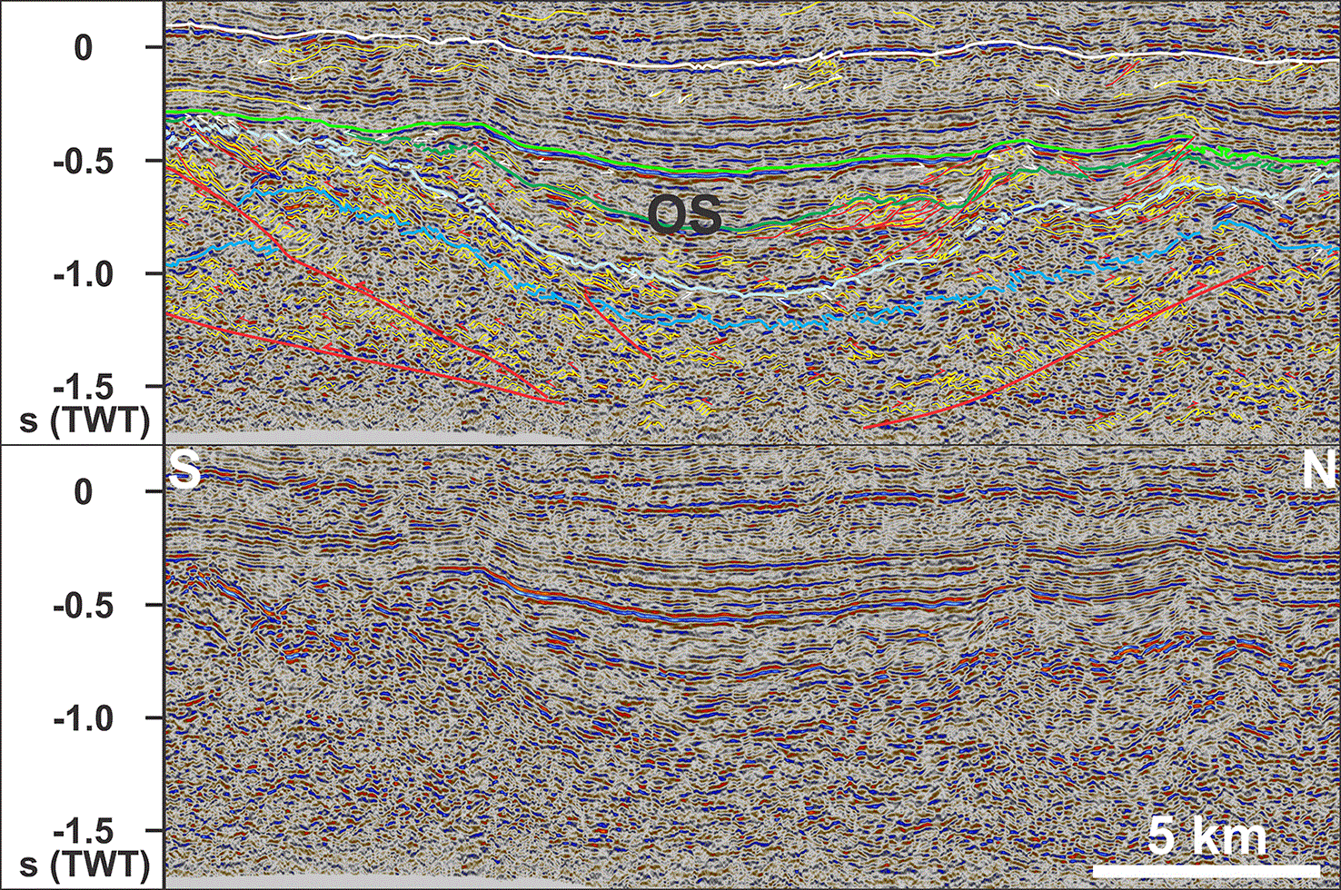
Figure 12. Interpreted (up) and uninterpreted (down) zoom in the Oriental syncline, showing comparable structures as in the Gaviota syncline, e.g., opposite vergence of asymmetric folds and thrust faults on either limb of the syncline, and thickening of the Lower Cretaceous succession (between dark and light green horizons) in the syncline hinge.
The northern half of the syncline displays bedding-parallel décollements and thrusts with duplex and antiformal stack geometries in Jurassic–Lower Cretaceous successions (between blue and dark green horizons). Notice the fewer thrust faults and relatively smaller (reverse) offsets than in the Gaviota syncline. See location and legend in
Figure 3a. Abbreviations: OS: Oriental syncline.
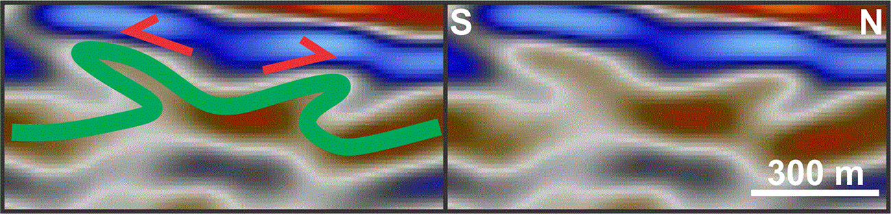
Figure 13. Interpreted (left) and uninterpreted (right) zoom in π-shaped reflections reflecting the occurrence of double-verging folds, i.e., limited tectonic transport.
See location and legend in
Figure 3a.
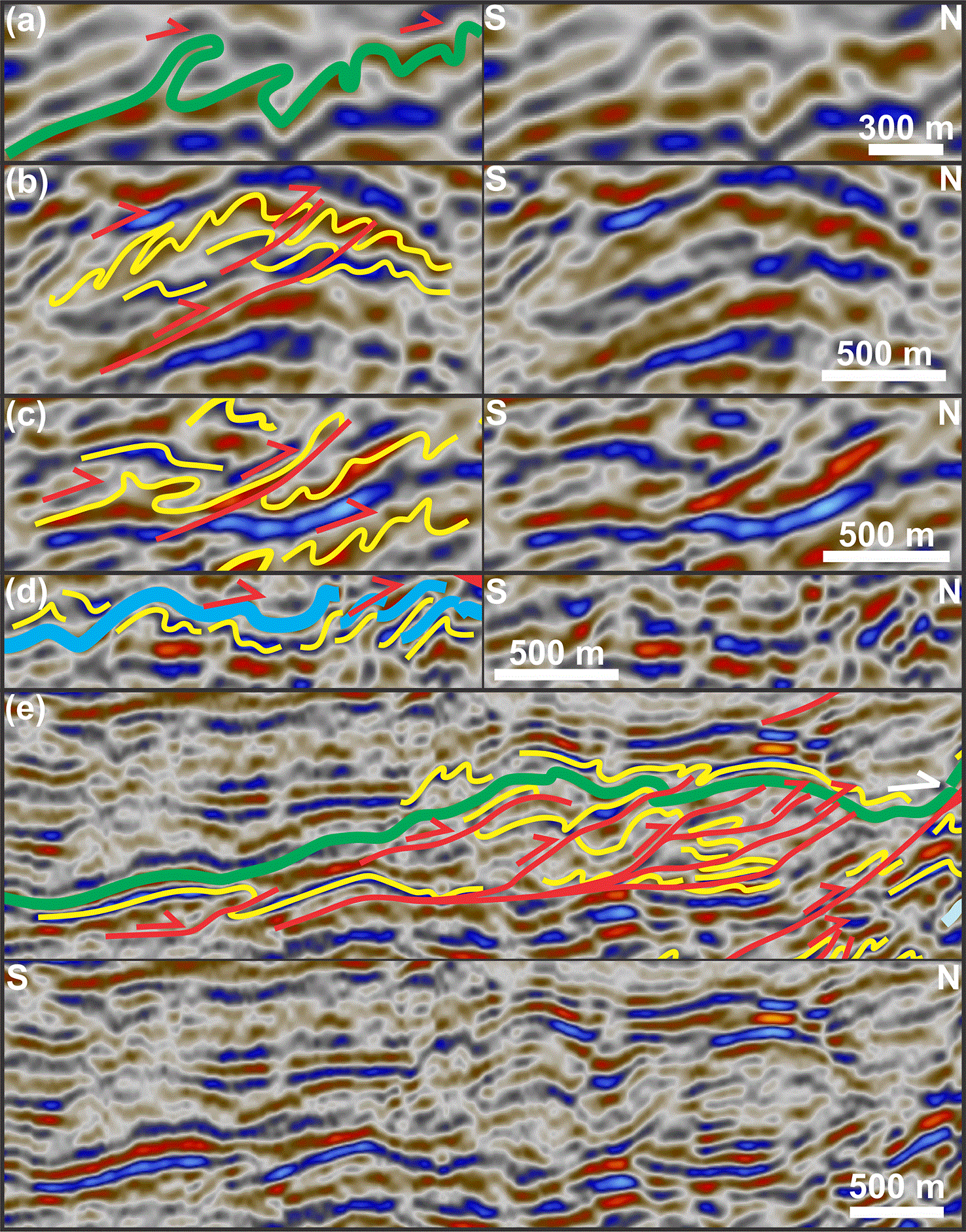
Figure 14. (a) Interpreted (left) and uninterpreted (right) zoom in NNE-verging, overturned to recumbent, isoclinal folds.
(b) Interpreted (left) and uninterpreted (right) zoom in NNE-verging asymmetric folds and minor, top-NNE thrusts in Jurassic volcanosedimentary rocks of the Gaviota syncline. The thrusts flatten downwards into bedding surfaces and, thus, possibly initiated as (partial) décollements. (c) Interpreted (left) and uninterpreted (right) zoom in dominantly NNE-verging asymmetric folds and top-NNE thrust in Jurassic rock units in the Gaviota syncline. Notice the occurrence of a double-verging, π-shaped fold in the south. (d) Interpreted (left) and uninterpreted (right) zoom in NNE-verging folds transitioning into top-NNE imbricate thrusts and/or (backward-dipping) duplexes. (e) Interpreted (up) and uninterpreted (down) zoom in imbricate thrusts soling into a bedding-parallel décollement and showing an early-stage, antiformal stack geometry. See location and legend in
Figure 3a.
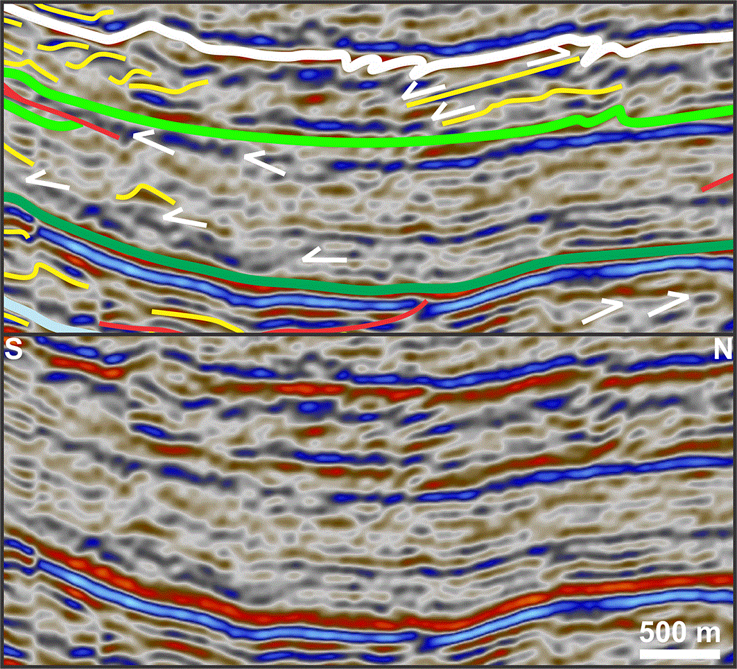
Figure 15. Interpreted (up) and uninterpreted (down) zoom in onlap, toplap, and downlap reflection geometries (white half arrows) in the Lower and Upper Cretaceous successions in the Gaviota syncline, suggesting respectively deposition during the formation of the Gaviota syncline in the mid-Early Cretaceous (onset of contraction), continued folding and uplift in the mid-Cretaceous resulting in regional erosion of Lower Cretaceous rock units (cf. Mid-Cretaceous unconformity; light green horizon), and a northern provenance for southward-prograding Upper Cretaceous succession.
See location and legend in
Figure 3a.
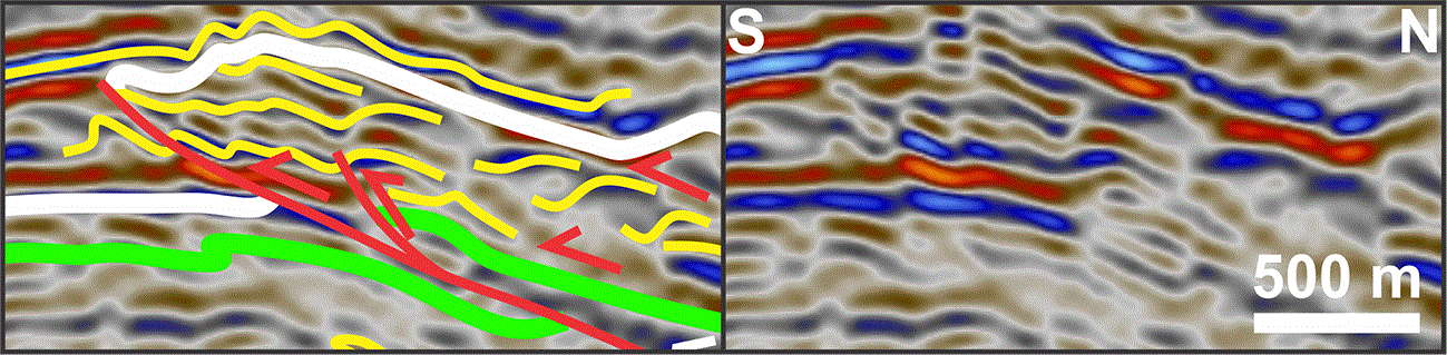
Figure 16. Interpreted (left) and uninterpreted (right) zoom in top-SSW, bedding-parallel décollement and minor thrusts and related SSW-verging asymmetric folds in Cretaceous–lower Cenozoic sedimentary rocks in the Gaviota syncline.
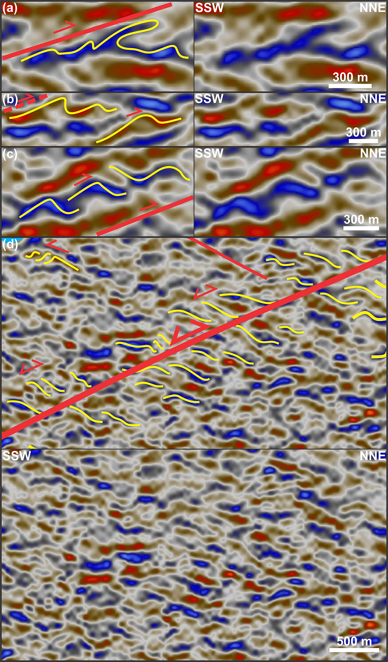
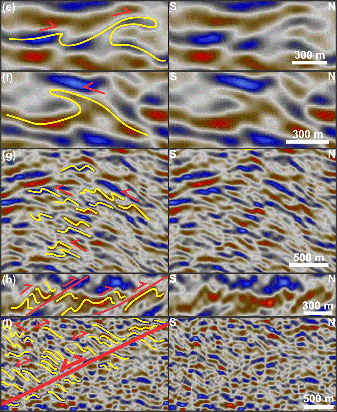
Figure 17. (a) Interpreted (left) and uninterpreted (right) zoom in a hundred-meter-scale, NNE-verging, recumbent, isoclinal fold in (Paleozoic?) basement rocks.
(b) Interpreted (left) and uninterpreted (right) zoom in hundred-meter-scale, inclined, open to close, NNE-verging asymmetric folds in basement rocks within the Mercedes fault zone. (c) Interpreted (left) and uninterpreted (right) zoom in NNE-verging asymmetric folds at the transition to an early-stage duplex geometry within the Mercedes fault zone. (d) Interpreted (up) and uninterpreted (down) zoom in potentially inverted, forward-dipping duplexes consisting of Z-shaped horses in the Fueguino syncline in the footwall of the Mercedes fault zone. (e) Interpreted (left) and uninterpreted (right) zoom in hundred-meter-scale, NNE-verging folds showing overturned close to recumbent isoclinal geometries in (Paleozoic?) basement rocks. (f
) Interpreted (left) and uninterpreted (right) zoom in a hundred-meter-scale, SSW-verging overturned isoclinal fold in basement rocks in the southern limb of the Gaviota syncline. (g) Interpreted (left) and uninterpreted (right) zoom in open, upright, symmetric folds and SSW-verging, inclined to overturned folds in basement rocks on the southern limb of the Gaviota syncline. (h) Interpreted (left) and uninterpreted (right) zoom in NNE-verging, inclined, open to close folds and top-NNE thrusts and associated forward-dipping duplexes in (Paleozoic?) basement rocks. (i) Interpreted (left) and uninterpreted (right) zoom in potentially inverted, top-NNE duplexes consisting of Z-shaped horses along a low-angle thrust fault in basement rocks on the northern limb of the Oriental syncline. See location and legend in
Figure 3a.
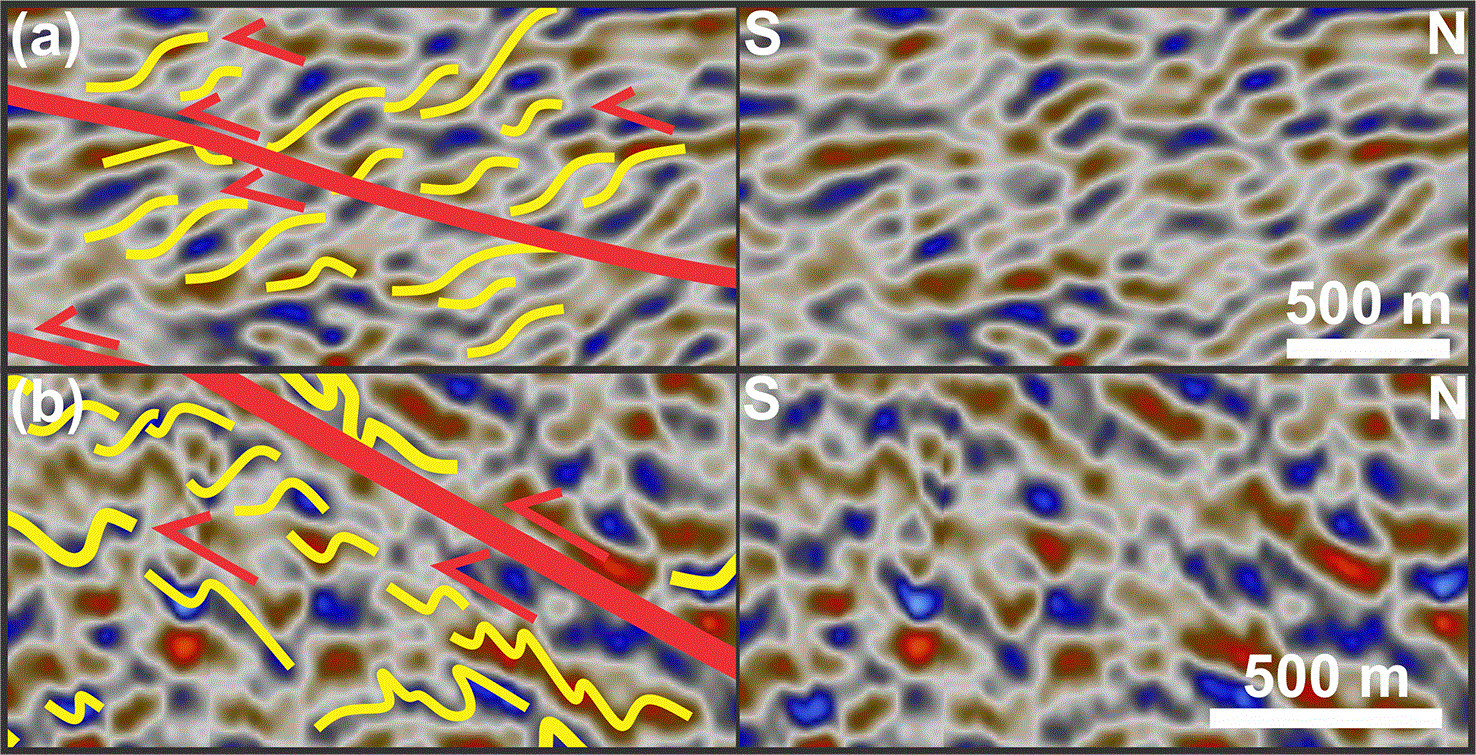
Figure 18. (a) Interpreted (left) and uninterpreted (right) zoom in (inverted?) top-SSW, S-shaped duplexes in basement rocks on the southern limb of the Gaviota syncline.
(b) Interpreted (left) and uninterpreted (right) zoom in SSW-verging asymmetric folds transitioning into top-SSW, S-shaped, forward-dipping duplexes in the footwall of a major thrust fault in basement rocks on the southern limb of the Gaviota syncline. See location and legend in
Figure 3a.
Similarly to the southwestern domain, the lower domain is crosscut by major disruption surfaces (
Figure 3a–h). However, these display both SSW- and NNE-dipping geometries and dip more gently than in the southwestern domain, thus truncating the U-shaped packages at an acute angle (
Figure 3a–h). Their upward terminations coincide with gentle, open, km-scale, upward curving geometries of the overlying, continuous reflections in the northeastern domain (
Figure 3a–h,
Figure 19,
Figure 20, and
Figure 21). Offset along major disruption surfaces in the lower domain are reverse and generally about a few hundred meters to a few km (≤ 5 km). Their dip direction typically but not exclusively matches that of bedding surfaces in the U-shaped packages, generally switching dip direction across the center of U-shaped packages (
Figure 3a–h,
Figure 11, and
Figure 12). A similar switch is observed for asymmetric reflections both within and below the U-shaped troughs, which display opposite vergence on either flank of U-shaped troughs (
Figure 3a–b and e–h,
Figure 11, and
Figure 12). Notably, they display dominantly S-shaped and SSW-leaning geometries (narrow and steep south-southwestern limb and long more gently dipping north-northeastern limb) on the NNE-dipping southern flank of the troughs and Z-shaped and NNE-leaning geometries on the northern, SSW-dipping flank of the troughs (
Figure 3a–b and e–h,
Figure 11, and
Figure 12).
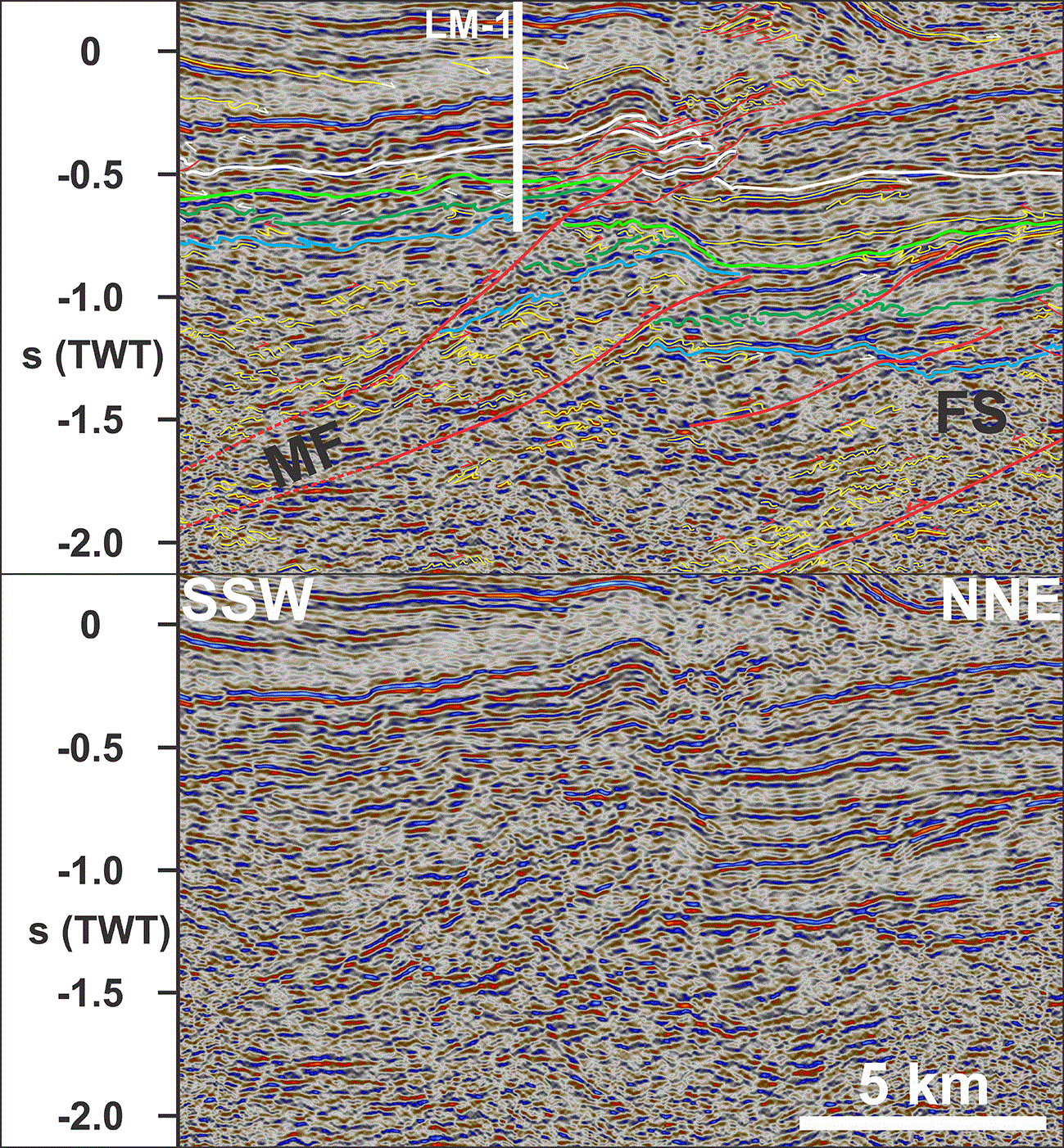
Figure 19. Interpreted (up) and uninterpreted (down) zoom in the Mercedes fault zone showing several km top-NNE offset of major pre-Cenozoic stratigraphic boundaries (i.e., blue and dark and light green horizons) consistent with NNE-verging folds and top-NNE duplexes along major thrust fault surfaces.
Upwards, the Mercedes fault zone splays into multiple, soft-linked segments showing hundred-meter- to km-scale offsets associated with a several km-wide, upright, open anticline in Upper Cretaceous–Cenozoic strata. See location and legend in
Figure 3a. Abbreviations: FS: Fueguino syncline; LM-1: Lago Mercedes 1 wellbore; MF: Mercedes fault zone.
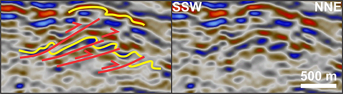
Figure 20. Interpreted (left) and uninterpreted (right) zoom in minor, top-NNE, imbricate thrusts within Cenozoic sedimentary strata above the Mercedes fault zone.
See location and legend in
Figure 3a.
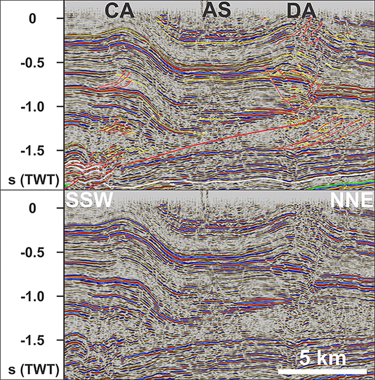
Figure 21. Interpreted (up) and uninterpreted (down) zoom in several km wide, upright, open folds about the Mercedes fault zone, i.e., in the proximal foreland of the Tierra del Fuego fold-and-thrust belt.
Notice the monoclinal geometry of the Constancia Anticline and the probable formation of the Despedida Anticline as detachment fold, i.e., formed in the hanging wall of a shallow, gently SSW-dipping, soft-linked segment of the Mercedes fault zone. See location and legend in
Figure 3a. Abbreviations: AS: Aurelia Syncline; CA: Constancia Anticline; DA: Despedida Anticline.
Upwards, the U-shaped troughs are bounded from prograding continuous reflections of the northeastern domain by a gently undulating, overall gently SSW-dipping, continuous, high-amplitude reflection, which truncates gently southwest- and northeast-dipping underlying reflections, resulting in toplap reflection geometries (light green horizon in
Figure 3a–h, and
Figure 15). In places, this horizon is offset in a reverse fashion by low-angle to sub-horizontal disruption surfaces, which typically flatten and die out within a few km downwards and within a few hundred meters upwards. Towards the southwestern domain, this high-amplitude reflection curves more tightly. In the southwestern domain, it is offset in a reverse fashion by several km along multiple, gently- to steeply-SSW-dipping disruption surfaces and can be tentatively traced up to a depth of 0.5 second (TWT;
Figure 3a–d and
Figure 4).
Northeastern domain
The northeastern domain consists of several elongated, wedge-shaped packages of continuous seismic reflections and thins from ca. 2.5 seconds (TWT) thickness in the southwest to ca. 1.5 seconds (TWT) in the northeast (
Figure 3a–h). Seismic reflections in the northeastern domain typically display prograding geometries, which result in gradual thinning of the seismic units and downlap reflection geometries in the direction of progradation and onlap and toplap reflection geometries in the opposite direction (
Figure 3a–h and
Figure 15). The thin (≤ 0.5 second thick; TWT) seismic succession at the bottom of the northeastern domain progrades northwards in the south and southwards in the north, thinning to ≤ 0.1 second (TWT) in the center of the study area (
Figure 3a–h). This succession is locally offset and abruptly thickens from ca. 0.1 to 0.5 second (TWT), e.g., above sets of gently to moderately SSW-dipping to subhorizontal disruption surfaces, some of which offset the lower domain by up to a few km top-northeast in the southwest near the location of the Lago Mercedes 1 wellbore (
Figure 3a–h and
Figure 19).
Internal reflection packages in the overlying, up to 2.0 seconds (TWT) thick succession, which makes up most of the northeastern domain, display dominantly NNE-prograding geometries (with minor local shifts in the north), thinning to a thickness of ca. 1.0 second (TWT) in the north. Disruption surfaces are generally absent in this thick succession, and only locally occur in conjunction with broad, open, km-scale upward curving of seismic reflections in the southwest, showing minor reverse offsets (≤ a few hundred meters;
Figure 3a–f,
Figure 20, and
Figure 21). The broad, open, upward-curving geometries generally extend into the lower domain, but in places are restricted to the upper part of the northeastern domain and coincide at depth with low-angle, dominantly SSW-dipping disruptions (
Figure 3a–f and
Figure 21).
Interpretation
Southwestern domain (Tierra del Fuego fold-and-thrust belt)
The highly disrupted, dominantly low-amplitude and asymmetric curving character of seismic reflections and the large number of major moderately- to steeply-SSW-dipping disruption surfaces in the southwestern domain suggest intensely deformed and ruptured bedding surfaces (
Figure 3a–d and
Figure 4). This is consistent with previous field studies in the area, which reported hundred-meter- to km-scale NNE-verging folds and top-NNE thrusts (e.g., Mosqueira González et al., 2021; Torres Carbonell et al., 2020; Zanella et al., 2014). The extent of the southwestern domain coincides with that of the Tierra del Fuego fold-and-thrust belt in surface outcrops. It is therefore interpreted as the subsurface expression of this orogen.
More specifically, the comparable size and geometry of NNE-verging folds in outcrops in the Sierra de Beauvoir, Sierra de Apen, and Lago Blanco (
Figure 1b–c) to that of asymmetric, dominantly ‘NNE-leaning’ and Z-shaped reflections in the southwestern domain suggest that the latter correspond to tightly folded sedimentary rocks and that their asymmetry indicates the direction of tectonic transport (
Figure 3a–d,
Figure 4,
Figure 5a–e,
Figure 7a–b, and
Figure 8a–d). The occurrence of asymmetric folds of opposite vergence on the opposite limbs of symmetric, (up to several) km-wide curving reflections suggest that the former initiated as parasitic folds on the limbs of (initially) broader, more gentle, typically open to close, in places chevron-like symmetric folds (
Figure 3a–d,
Figure 4,
Figure 6,
Figure 7a–b,
Figure 9a–c, and
Figure 10). The numerous stacks of NNE-leaning and Z-shaped asymmetric folds, especially adjacent to major disruption surfaces, suggest the occurrence of dense networks of folds and faults defining shear fabrics probably arranged in contractional duplexes, e.g., antiformal (thrust) stacks, forward-dipping duplexes, imbricate fans, including link thrusts, bedding-parallel décollements, and roof and floor thrusts and detachments (Boyer & Elliott, 1982; Koehl, 2021; McClay, 1992; McClay and Insley, 1986).
The tight deformation (e.g., NNE-verging folds and duplexes;
Figure 4,
Figure 5a–e, and
Figure 8a–d) and up to 5–10 km top-NNE reverse offsets (e.g., Mid-Cretaceous unconformity; light green horizon in
Figure 3a–d and
Figure 4) along the tens of km wide, up to 3.0 seconds (TWT) thick (i.e., several km thick), moderately to steeply SSW-dipping disruption surfaces in the southwestern domain (i.e., in the Tierra del Fuego fold-and-thrust belt) suggest that they correspond top-NNE thrust faults (
Figure 3a–d and
Figure 4). This is supported by the occurrence of dominantly top-NNE brittle–ductile thrusts and shear zones of the Tierra del Fuego fold-and-thrust belt in outcrops in the study area and is consistent with the dominance of NNE-verging folds in the southwestern domain both in outcrop and the subsurface (Mosqueira González et al., 2021; Torres Carbonell et al., 2020; Zanella et al., 2014;
Figure 3a–d,
Figure 4,
Figure 5a–e, and
Figure 8a–d).
Furthermore, offset seismic horizons are generally curving upwards above and downwards below major disruption surfaces (e.g., light green horizon in
Figure 4 and
Figure 5b–c and e). This together with the imbricate (i.e., partly overlapping), fan-shaped arrangement (i.e., flattening at depth and merging with a gently SSW-dipping disruption surface) suggests that the disruption surfaces correspond to top-NNE imbricate thrusts with related ramp anticlines in the hanging wall and footwall synclines (
Figure 3a–d,
Figure 4, and
Figure 5b–c and e; McClay, 1992). This is consistent with previous studies of seismic reflection data in the area (e.g., Álvarez-Marrón et al., 1993; Gallardo Jara et al., 2022). Five discrete clusters of SSW-dipping thrust surfaces are recognized in the southwestern domain (
Figure 3a–d and
Figure 4). The upper four clusters of moderately- to steeply-dipping surfaces correlate from north to south with the Vicuña, Bahia Bell, Yartou, and Colo-Colo fault zones and the lower, gently-dipping thrust surfaces coincide with the sole thrust at the base of the imbricate thrust fan (Álvarez-Marrón et al., 1993; Gallardo Jara et al., 2022; Zanella et al., 2014). Similarly to Álvarez-Marrón et al. (1993), the present interpretation separates the steeply-dipping Vicuña fault zone from the low-angle sole thrust, the former merging into the latter at depth (
Figure 3a–d and
Figure 4).
Thin, up to a few km wide fault-bounded slivers of Lower Cretaceous sedimentary rocks of the Río Jackson and Beauvoir–Vicuña formations crop out and were penetrated by the Vicuña 1 and Vicuña 2 wellbores along the Vicuña fault zone at Lago Blanco (Zanella et al., 2014). In the subsurface, these units appear intensely deformed into thrust-parallel imbricates dragged along major fault surfaces (light green horizon along the Vicuña and Yartou fault zones in
Figure 3a–d and
Figure 4). These suggest that weak (shale–slate-rich) Lower Cretaceous rocks of the Río Jackson and Beauvoir formations (and possibly Jurassic–earliest Cretaceous, interbedded volcanics and clastic rocks of the Tobífera Formation?) acted as a décollement that initially localized the formation of the Vicuña and Yartou fault zones, which later evolved into major detachments (
Figure 3a–d,
Figure 4, and
Figure 5d–e). This is consistent with previous tectonic models for the study area (Álvarez-Marrón et al., 1993; Zanella et al., 2014).
In the southwesternmost part of the data, a moderately-NNE-dipping disruption surface parallels and occurs just below the Mid-Cretaceous unconformity (
Figure 3a–d and
Figure 4). It is suggested that this disruption surface corresponds to the northern subsurface continuation of the Río Jackson detachment (back thrust), which crops out a few km south of the seismic section shown in
Figure 3a–b and occurs between Jurassic–earliest Cretaceous rocks of the Tobífera and Lemaire–Lapataia formations and Lower Cretaceous strata of the Río Jackson Formation (Klepeis, 1994a; Torres Carbonell et al., 2020). This provides some constraints on the approximate depth of this stratigraphic boundary in the southwestern end of the data, which deepens northwards in a step-like manner across major thrust faults within the Tierra del Fuego fold-and-thrust belt, except along the Vicuña and Yartou fault zones (
Figure 3a–d and
Figure 4). This suggests the presence of a wedge of pre-Jurassic (likely Paleozoic igneous and metamorphic) basement rocks characterized by moderate-amplitude reflections at depth ≥ 0.5 second (TWT) in the southwestern part of the Tierra del Fuego fold-and-thrust belt (
Figure 3a–d and
Figure 4). However, the absence of wellbores and numerous thrust faults in this area make regional stratigraphic correlations in the southwestern domain relatively uncertain.
While the apparent top-NNE offsets indicate brittle (cataclastic) deformation (e.g., Mosqueira González et al., 2021), the high-amplitude, locally asymmetrically folded geometry of the reflections characterizing the thrust faults suggests the occurrence of relatively dense rocks along the faults (
Figure 4). A probable candidate is mylonite, which typically develops along major thrust fault surfaces and has a higher density due to the formation of high-grade metamorphic minerals during deformation (e.g., Arbaret & Burg, 2003; Bell & Etheridge, 1973; Bell & Hammond, 1984; Colombu et al., 2015; Lapworth, 1885; Platt, 1983; Sibson, 1977; Sibson, 1980; White et al., 1980). Thus, mylonitic thrust surfaces generally appear as dominantly planar (locally folded), high-amplitude seismic reflections in seismic reflection data (e.g., Christensen, 1965; Christensen, 1966; Fazlikhani et al., 2017; Fountain et al., 1984; Hurich et al., 1985; Koehl et al., 2022; Phillips et al., 2016; Reeve et al., 2013), i.e., comparable to disruption surfaces in the Tierra del Fuego fold-and-thrust belt in the south, which are hence interpreted as brittle–ductile thrust systems (
Figure 3a–d and
Figure 4). This is supported by outcrops of mylonites in the Tierra del Fuego fold-and-thrust belt in the study area (Esteban et al., 2011; González Guillot et al., 2010; Menichetti et al., 2008; Suárez et al., 2000; Torres Carbonell et al., 2020) and farther west (Muller et al., 2020), and in the Darwin Cordillera in the south (Betka et al., 2022; Nelson et al., 1980).
Lower domain (Paleozoic basement rocks)
The transition from dominantly low-amplitude, highly disrupted reflections of the wedge-shaped southwestern domain (i.e., Tierra del Fuego fold-and-thrust belt) to moderate–high-amplitude reflections of the lower domain suggests a change in both rock type and deformation style across the gently SSW-dipping disruption surface (i.e., sole thrust;
Figure 3a–d). A notable abrupt change is the gentler dip of major disruption surfaces within the lower domain (
Figure 3a–d). Since these are also typically associated with km- to several-km-scale top-NNE reverse offsets (e.g., blue and light green horizons in
Figure 3a–d and
Figure 4) and NNE-verging asymmetric- and Z-shaped reflections, which are comparable to those along disruption surfaces in the overlying southwestern domain (i.e., Tierra del Fuego fold-and-thrust belt), they are interpreted as major brittle–ductile thrust faults. The abrupt change from moderate–steep to more gentle dips of thrust faults in the lower domain indicates a major rheological boundary. It is therefore proposed that the lower domain consists mostly of tightly deformed Paleozoic basement rocks of the Tierra del Fuego igneous and metamorphic complex (
Figure 3a–d and
Figure 4).
The presence of a major rheological boundary between the southwestern and lower domains is supported by the location and attitude of the sole thrust, i.e., subparallel to and partly localized along the interpreted boundary between Paleozoic basement and Mesozoic volcanosedimentary rocks (i.e., blue horizon in
Figure 3a–d and
Figure 4). It is also supported by the (thrust-related) thickening of pre-Cordilleran (i.e., pre-contraction), Jurassic–Lower Cretaceous volcanosedimentary units in the Tierra del Fuego fold-and-thrust belt (up to 0.4–0.5 second TWT) compared to equivalent strata just north of the fold-and-thrust belt (ca. 0.1–0.2 second TWT and c. 500 m thick in the Lago Mercedes 1 wellbore; Gallardo Jara et al., 2022;
Table 1), which suggests partial strain partitioning by these units. This is consistent with previous seismic interpretation in the area (e.g., Álvarez-Marrón et al., 1993; Gallardo Jara et al., 2022).
North of the Tierra del Fuego fold-and-thrust belt, most major low-angle thrust faults there die out below the Mid-Cretaceous unconformity, thus suggesting that these mostly formed prior to the mid-Cretaceous and/or strain partitioning (and, thus, a possible major rheological boundary) between the lower domain and northeastern domain (
Figure 3a–h). A notable exception is the thrust fault system below the Lago Mercedes 1 wellbore, which offsets the Mid-Cretaceous unconformity and Base Cenozoic horizon by up to c. 2 km top-NNE and coincides with a broad, c. 5 km wide, asymmetric upright anticline to monocline in the overlying northeastern domain (
Figure 3a–d and
Figure 19). This fault system correlates with the Mercedes fault zone (Gallardo Jara et al., 2022).
A major rheological boundary between the lower and northeastern domains is further supported by the occurrence of multiple gently dipping to subhorizontal, a few km wide disruption surfaces displaying hundred-meter- to km-scale reverse offsets of Mesozoic volcanosedimentary units and the Mid-Cretaceous unconformity and Base Cenozoic horizons (
Figure 3a–h,
Figure 11,
Figure 12, and
Figure 16). Their subhorizontal, downward-flattening geometry, i.e., subparallel to stratigraphic boundaries, suggests that they correspond to minor décollements–detachments.
North of the sole thrust of the Tierra del Fuego fold-and-thrust belt, major thrust faults and associated asymmetric folds and duplexes in the lower domain show alternating top-NNE and top-SSW kinematics, including both S- and Z-shaped duplex horses (
Figure 3a–h,
Figure 4,
Figure 11,
Figure 12,
Figure 14a–e,
Figure 17a–i, and
Figure 18a–b). Notably, they display opposite kinematics on opposite flanks of the U-shaped troughs of Jurassic–Lower Cretaceous units (
Figure 3a–b and e–h,
Figure 11,
Figure 12,
Figure 14a–e, and
Figure 16). For example, structures along the northern flank of the Gaviota and Oriental (also called Ostión and Calafate) troughs include NNE-verging asymmetric folds and top-NNE thrust faults and Z-shaped duplexes, whereas the southern flanks show SSW-verging folds and top-SSW thrusts and S-shaped duplexes (
Figure 3a–b and e–h,
Figure 11,
Figure 12, and
Figure 18a–b). In addition, the local π-shaped geometry of asymmetric reflections in U-shaped seismic packages suggest double-verging folds (
Figure 13). Like between the southwestern and lower domains, the subparallelism of major thrust faults and stratigraphic boundaries suggests that these localize strain partitioning, which is in agreement with the rheological difference between competent igneous and metamorphic basement rocks and weaker volcanosedimentary rocks.
The U-shaped geometry and the occurrence of folds and thrust faults with opposite kinematics on either flank of the Gaviota and Oriental troughs, together with evidence of oppositely-verging parasitic folds on the limbs of several-km-wide symmetric folds in the Tierra del Fuego fold-and-thrust belt in the southwest suggest that the two troughs correspond to tens of km wide, upright synclines, hereby named the Gaviota and Oriental synclines. The erosional truncation (e.g., toplap reflection geometries) of gently north-and south-dipping Jurassic–Lower Cretaceous strata indicate that these folds formed in the mid-Cretaceous (
Figure 3a–b and e–h and
Figure 15).
Overall, Paleozoic–Mesozoic rocks in the lower domain show a northwards decrease in the intensity of contractional deformation, i.e., in agreement with previous works in the area. This is exemplified by the transition from large, several km wide, top-NNE offsets and tight (e.g., isoclinal recumbent) folding of Mesozoic–Cenozoic successions along the sole thrust and multiple imbricate thrust faults in the Tierra del Fuego fold-and-thrust belt (
Figure 3a–d and
Figure 4) to localized km-scale offset at the Mercedes fault zone (
Figure 19) and hundred-meter- to km-scale offsets along sparser, oppositely-dipping thrust faults and gentle open (in places, π-shaped double-verging) folding of Mesozoic–Cenozoic strata in the north (
Figure 3a–b and e–h and
Figure 13).
Northeastern domain (Magallanes foreland basin)
Overall, the largely continuous character of seismic reflections in the northeastern domain suggests it consists of relatively undeformed sedimentary strata (
Figure 3a–h). This is supported by the low number of disruption surfaces (apart from a few subhorizontal décollement–detachments in the lower part) in this domain and by local gentle, open folding in the southwestern part (
Figure 3a–h,
Figure 20, and
Figure 21). There, broad, gentle, open anticlines north of the Tierra del Fuego fold-and-thrust belt coincide from south to north with the Miraflores Anticline, which dies out to the southeast (Álvarez-Marrón et al., 1993), and the Constancia Anticline, Aurelia Syncline, Despedida Anticline, and Moneta Anticline (
Figure 1c,
Figure 3a–f,
Figure 20, and
Figure 21; Torres Carbonell et al., 2013). While most folds affect the entire rock column, some only affect the uppermost successions and coincide at depth with low-angle, dominantly SSW-dipping disruption surfaces (e.g., Despedida Anticline;
Figure 3a–f,
Figure 20, and
Figure 21). These are interpreted as detachment folds, in agreement with previous studies in the area (e.g., Torres Carbonell et al., 2013).
The localization of deformation in the southwest and significant southward thickening of the northeastern domain and of dominantly northward-prograding individual successions suggest that this domain consists of Upper Cretaceous–Cenozoic sedimentary deposits related to uplift and erosion in the Tierra del Fuego fold-and-thrust belt in the southwest, i.e., corresponding to the Magallanes foreland basin. More specifically, the northward- and southward-prograding character of seismic reflections and associated thinning of the basal succession towards the center of the northeastern domain and the correlation of this seismic succession with Upper Cretaceous sedimentary rock units in nearby wellbores suggest initial sediment input from the north and south in the Late Cretaceous (
Figure 3a–h and
Figure 11). In addition, local thickening in conjunction with the absence of or limited deformation of this unit in the footwall of major thrust faults (e.g., Mercedes fault zone) indicates a syn-thrusting deposition (
Figure 19). This succession is therefore suggested to reflect the onset of significant uplift and erosion in the Tierra del Fuego fold-and-thrust belt (i.e., early-foreland sediments), which is consistent with previous interpretation (e.g., Gallardo Jara et al., 2022).
The up to 2.5 seconds thick overlying succession of northward-prograding and northward-thinning reflections and units indicates sediment input almost exclusively from the Tierra del Fuego fold-and-thrust belt (
Figure 3a–h). Hence, it is interpreted as the main Cenozoic foreland succession of the Magallanes basin. This is consistent with the gradual northward thinning of Cenozoic sedimentary rock units in nearby exploration wells from > 3000 m thick in the south (Lago Mercedes 1 wellbore) to c. 1000 m in the north (e.g., María Emilia 3 wellbore; Gallardo Jara et al., 2022;
Figure 3a–h and
Table 1).









