1. Introduction
The work presented herein has been conducted within the AgriBIT project,1 funded by the EU Horizon 2020 programme2 under the coordination of the European Union Agency for the Space Programme (EUSPA),3 and is currently being extended through the ENACT project.4 The goal of AgriBIT is to improve the agricultural value chain by delivering higher-precision, more accurate and continuously available precision-agriculture (PA) services that combine GNSS — and in particular high-precision Galileo positioning together with EGNOS augmentation — with Earth Observation (EO) information, on-field and on-machine sensors and actuators, Artificial Intelligence (AI) and expert agronomic knowledge. Its objectives span (1) market and needs analysis, (2) higher-precision location services, (3) an affordable, European-sourced high-precision Galileo/EGNOS GNSS receiver, (4) a bundle of PA services for farmers and advisors, (5) a strategy for service uptake, and (6) an open, service-oriented platform.
Whereas an earlier paper focused narrowly on the design and validation of the custom GNSS receiver, this article takes a broader view. It describes how centimetre-accurate positioning acts as the backbone of an integrated smart-farming platform in which multispectral remote sensing, IoT monitoring and AI analytics are fused into a georeferenced digital twin of the field. The contributions are fourfold: we (i) summarise the layered platform architecture and the PA services it delivers; (ii) report the design and validated performance of the RFSAT high-precision GNSS receiver; (iii) demonstrate how centimetre georeferencing enables high-resolution multispectral 3D crop modelling and vegetation-index products; and (iv) show how the fused datasets feed AI-based crop-health analytics, illustrated with a deep-learning pest-detection service. Results are drawn from operational pilots in Greece, Portugal and Italy.
2. Integrated smart-farming architecture
The platform is organised into three cooperating layers (Figure 1). At the physical layer, a GNSS sensor provides precise position, speed and orientation to ground and aerial vehicles, while EO data, agricultural machinery, UAVs and in-field PA sensors act as data sources and actuators. The data-processing layer hosts the GNSS-enabler services (data acquisition, boundary extraction, route planning and guidance) alongside the PA services and a data repository. The application layer exposes cross-visualisation dashboards and collaboration services — open APIs, big-data-analytics services and open-source components — through which farmers, advisors and third-party providers consume site-specific measurements, alerts and interactive maps.
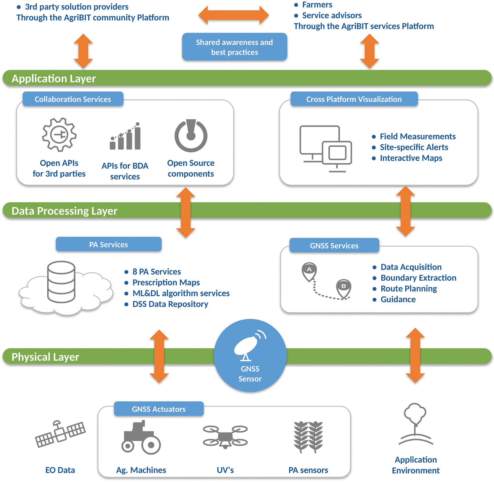
Figure 1. Layered architecture of the RFSAT/AgriBIT integrated precision-agriculture platform, fusing GNSS, Earth Observation, IoT sensing and AI analytics across the physical, data-processing and application layers.
The distinctive feature of the architecture is the tight fusion of GNSS with EO and in-situ information. Centimetre-accurate positioning allows every observation — whether a multispectral image captured from a UAV or a reading from an environmental sensor — to be placed on a common, highly accurate spatial reference. Combined with AI, this fusion supports automated detection and classification of field issues from surveillance imagery, automated machine operations, and decision support in which machine-learning algorithms reuse previous experience. The modular design lets end-users adopt individual elements selectively and gradually, keeping the solution flexible and competitive across a wide range of exploitation scenarios.
On top of this architecture the platform delivers a coherent bundle of PA services: climate services for farmers, tillage and irrigation scheduling, prescription mapping for irrigation, fertilisation and spraying, crop-growth monitoring, crop-yield estimation, and early warning for pests and diseases. These services draw on heterogeneous data sources — in-situ weather and pollution sensors, mobile sensors on UAVs and vehicles, open-data platforms and EO products from Copernicus/Sentinel-25 and Landsat-8,6 complemented where useful by commercial monitoring services such as EOS Crop Monitoring7 and CropSAT/Dataväxt8 to maintain service availability even under high cloud cover.
3. Pilot sites and validation context
The technologies were validated at operational pilot sites chosen to represent high-value Mediterranean cropping systems with contrasting agronomic challenges (Figure 2). The Greek pilot focuses on the full management of peach orchards — and, in adjacent trials, olive groves — where tree-canopy geometry limits the usefulness of coarse EO and UAV data and therefore benefits most from centimetre-accurate 3D modelling. The Italian pilot covers roughly 200 ha of vineyards, emphasising automated guidance, reduced water use and interoperability with other farm-management platforms. The Portuguese pilot addresses open-field tomatoes, targeting earlier, in-season detection of disease so that corrective measures can be applied before harvest.

Figure 2. Operational pilot sites spanning high-value Mediterranean crops: peach orchards and olives (Greece, left), vineyards (Italy, centre) and open-field tomatoes (Portugal, right).
Across these sites the same integrated workflow was exercised end-to-end: centimetre-accurate georeferencing of UAV and ground observations, generation of multispectral 3D crop models and vegetation-index maps, fusion with IoT and EO data, and AI-based analysis of crop health. The diversity of crops, canopy structures and climates provided a demanding test of both accuracy and robustness.
4. High-precision GNSS positioning
Precise positioning is the backbone of the whole platform. Based on the state-of-the-art analysis carried out in AgriBIT, a challenging set of performance targets was derived, respecting explicit user needs while remaining competitive with the best commercial solutions; the performance ultimately achieved against them is summarised in
Table 1. In the field, the receiver combines multiple constellations (Galileo, GPS, GLONASS and BeiDou) with SBAS augmentation — primarily EGNOS — to reach roughly 30 cm horizontal accuracy. Beyond this, RTK corrections are applied to reach the 1–2 cm level requested by users. The commonly adopted approach streams PPP-RTK corrections as RTCM messages over terrestrial IP networks, either from a commercial service or from a locally deployed reference station. Both were tested in AgriBIT: a third-party NTRIP service from HEXAGON,9 and in-situ RTK ground stations based on the DJI D-RTK 210 and an EOS Arrow Gold receiver.11
Table 1. Performance of the GNSS receiver built by RFSAT.
| Spec | Description |
|---|
| Constellations | GPS, Galileo, BeiDou, GLONASS and QZSS |
| SBAS support | EGNOS & WAAS detected |
| Accuracy (autonomous) | HPOS <1 m (static) / <1.75 m (dynamic); VPOS <2.16 m (static) / <2 m (dynamic) |
| Accuracy (SBAS) | HPOS <13.6 cm (static) / <50 cm (dynamic) |
| Accuracy (RTK) | HPOS <0.99 cm (static) /0.8–1.31 cm (dynamic); VPOS <2.2 cm (static) /1.9 cm (dynamic, D-RTK2) |
| Reliability | 95–99% |
| TTFF | Cold start <60 s (incl. Base connect); fix <30 s; reacquisition <10 s with LTE (float) |
| Output I/F | Bluetooth and USB (UART) |
| Protocol | NMEA-0183 (all navigational and status messages) |
| Networking | Embedded Wi-Fi and cellular modems |
| OS supported | Any OS with a web browser |
| Form factor | 55 × 35 × 45 mm (LCD); 55 × 35 × 35 mm (no LCD) |
| Weight | <200 g (prototype) |
| Price | £436 (prototype) |
| Autonomy | 13.4 h with 3350 mAh Li-Ion USB power bank |
| Power supply | <5.13 V & <0.25 A in RTK mode |
| ISOBUS | Provision for ISOBUS-11783 anticipated |
As documented in the AgriBIT deliverable D3.3,22 RFSAT provided RTK augmentation to the project in three complementary ways: an embedded solution based on the EOS Arrow Gold device (supporting L1/L2/L5 frequencies) reaching a final horizontal accuracy of about 0.6 cm; the DJI D-RTK 2 base station used as a local reference (GPS, Galileo, BeiDou and GLONASS) giving relative horizontal accuracy of 1–2 cm; and a third-party PPP-RTK (NTRIP) service, for example from METRICA/HEXAGON, also achieving 1–2 cm horizontally. Throughout these developments, RFSAT’s prior experience with software-based GPS and Galileo models built in MATLAB was used to advantage, proving analytically that the required relative or absolute positioning precision could be achieved before committing it to hardware.
A local RTK reference station sits close to the rover, keeping timing corrections as accurate as possible, whereas commercial services may be tens of kilometres away, where differing satellite delays can dilute the achievable precision. Nevertheless, provided the baseline to the commercial reference station stays within about 50 km, its cost is significantly lower than that of a dedicated station; unless the required precision exceeds what the commercial service delivers, deploying a custom station in the field is not recommended. Because RTK corrections must be communicated from terrestrial stations, the receiver integrates IP connectivity — embedded Wi-Fi and a cellular modem — to reach the correction service directly or via a paired smartphone.
The receiver prototype (Figure 3) is built around a u-blox multi-frequency GNSS module (ZED-F9R)12, 22 providing position and RTK fix, a Quectel BG95 LTE modem13 with GPRS fallback for reaching the RTCM streaming service, and an ESP32 microcontroller14 running an NTRIP client and logging NMEA output15 to an SD card. The GNSS module alone provides up to ~30 cm accuracy with SBAS; injecting RTK corrections raises this to the centimetre level with >95% availability. The F9P chipset can act as either base or rover, whereas the F9R offers rover functionality with dead-reckoning. A multiband antenna connects to the SMA-F socket; where Wi-Fi delivers the RTCM stream the cellular board can be omitted, shrinking the device to roughly 3 × 4 × 2 cm. Power can be drawn from battery, 12/24 V vehicle supply or backup solar panels, and an optional module reads speed and heading from the CAN bus for dead reckoning. An optional LAN module with RJ45 addresses scenarios where a wireless RTCM stream is undesirable. Optional support for ISO 11783-9 (Tractor ECU)16 is provisioned for direct connection to agricultural machinery over CAN.
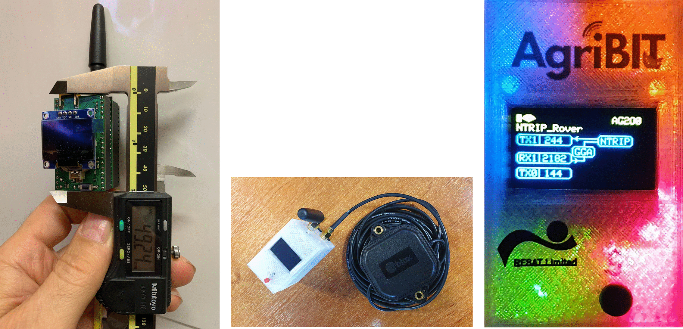
Figure 3. The RFSAT high-precision GNSS receiver: board-level design (left), the complete cased prototype with OLED display and antenna (centre), and the device operating in RTK-fixed mode (right).
Maximising configurability was a core priority. An embedded web interface (Figure 4) exposes the full device functionality — switching between Wi-Fi and cellular modems, configuring RTK-service access and cellular options, and selecting which NMEA messages (GGA, RMC, DTM, GLL, GNS, GSA) are delivered and how (Wi-Fi, Bluetooth or UART over USB). The modular build lets each unit be tailored to a specific application while minimising complexity and cost.
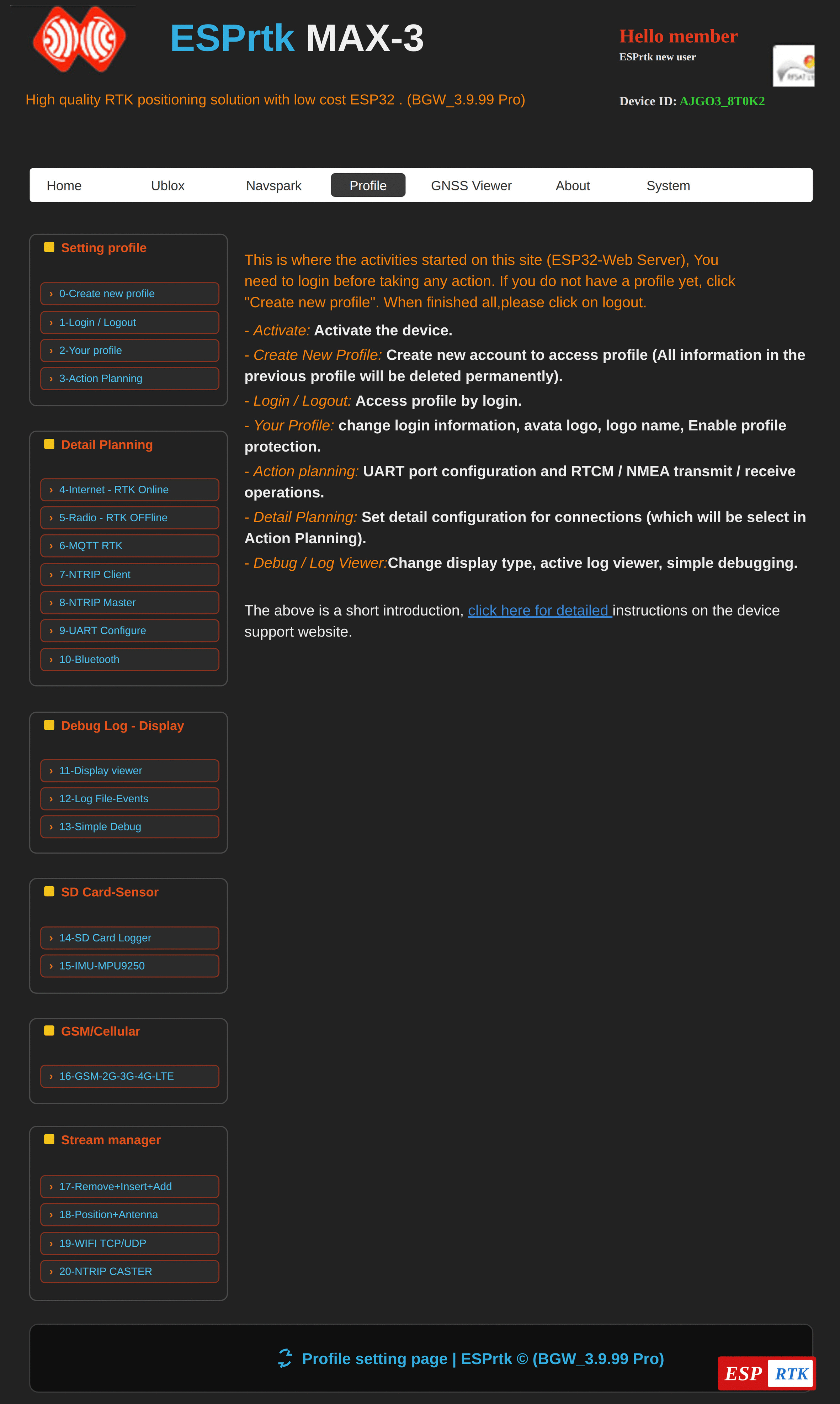
Figure 4. Embedded web interface (ESPrtk MAX-3) for configuring the GNSS receiver.
5. Technical Validation of the GNSS Receiver
Development of the custom receiver concluded with extensive technical validation against the derived specifications, culminating in a prototype ready for pilot deployment. Recent effort resolved design issues (F9P compliance, ISOBUS support, RTK-service interfacing) and customisation options (GPIO, SIM, NMEA), as well as unforeseen problems — replacing incompatible SIM cards, adapting to the EU-wide withdrawal of 2G/3G services — while optimising the precision-versus-power trade-off. Validation involved individual compliance tests in the laboratory and the field, in both static and dynamic (in-vehicle) scenarios; for added stringency, dynamic tests were driven in the city to increase shading and multipath rarely seen in rural areas. The final prototype fully met both user needs and formal specifications.
Table 1 summarises the key performance indicators achieved.
Antenna choice proved a critical and economical factor in reaching centimetre accuracy. While an EOS active antenna (≈£800) gave the best performance, a u-blox active antenna (≈£60) was ultimately selected — a tenfold cost reduction for the loss of only about half a centimetre of precision. The distance to the RTK reference station also had a measurable impact: a third-party station ~30 km away was compared with a D-RTK 2 station at the field itself, the latter improving accuracy by more than half a centimetre.
In the static RTK test the receiver achieved approximately 0.96 cm horizontally and 1.88 cm vertically (±3% spread), as shown in Figure 5. Similar horizontal accuracy was observed in the dynamic test (Figure 6), with vertical accuracy relaxing slightly to about 2.13 cm at a comparable ±3% spread. These results confirm that a European-sourced, low-cost receiver can deliver the centimetre-level georeferencing on which the remainder of the platform depends.
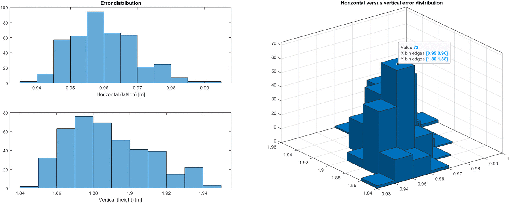
Figure 5. Horizontal and vertical error distributions achieved by the receiver in static RTK mode.
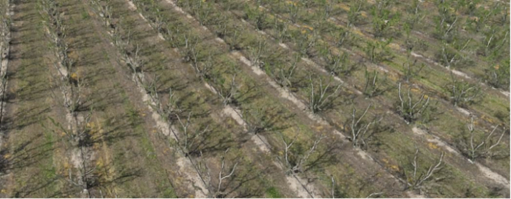
Figure 6. Positioning performance of the receiver in a moving vehicle (dynamic RTK test).
6. UAV multispectral remote sensing and 3D crop modelling
The rise of UAS with embedded precision GNSS has made highly accurate aerial surveillance practical for agriculture. AgriBIT adopted the DJI Mavic 3 Multispectral (Mavic 3 M),17 whose payload combines a 20-megapixel RGB camera with narrow-band Green (560 ± 16 nm), Red (650 ± 16 nm), Red-edge (730 ± 16 nm) and Near-Infrared sensors, together with a sunlight sensor that records solar irradiance for light compensation — yielding more accurate and temporally consistent NDVI and other indices. The design is compatible with earlier RFSAT work on multispectral surveillance using the Parrot Sequoia+ camera,18 whose multispectral and sunshine sensors likewise assess plant vitality from absorbed and reflected light.
The decisive contribution of the RFSAT receiver is the improvement of image georeferencing from the 2.5–5 m of standard GNSS to 1–2 cm. This step-change transforms the resulting 3D reconstructions: instead of merely recognising bushes and plants, individual branches and even flower petals can be resolved and modelled from imagery captured above 30 m. In a representative survey, 245 twenty-megapixel images were captured by the Mavic 3 M over a 150 × 30 m field from 26 m altitude (Figure 7), and the receiver’s ~ 1 cm positioning enabled an accurate photogrammetric reconstruction and volumetric analysis of crop growth not attainable with standard GNSS. A comparable survey flown in the earlier FP7-AF3 project21 with a standard receiver is shown alongside for reference. In AgriBIT pilot trials at ACP in Greece, relative positioning of the DJI Mavic 3 M imagery was achieved to within 2.6 cm horizontally and 5 cm vertically.22
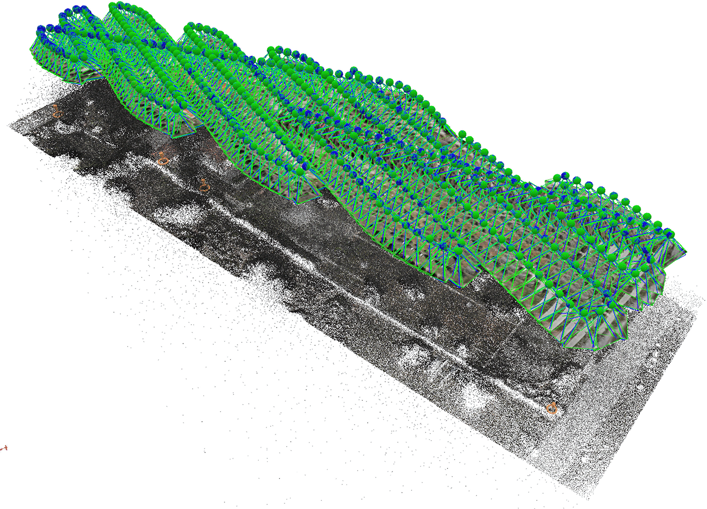
Figure 7. Dense photogrammetric point cloud/3D mesh of crop rows reconstructed from centimetre-georeferenced UAV imagery.
Beyond photogrammetry, centimetre georeferencing lets the platform build orthomosaics with a ground sampling distance of roughly 0.5 cm/pixel (Figure 8).
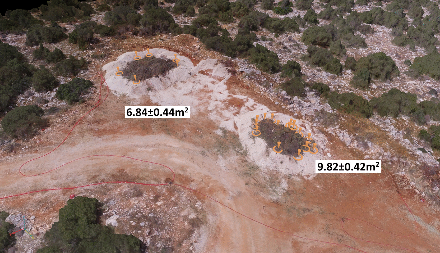
Figure 8. The 3D crop-canopy models for comparable field sizes: (top) AgriBIT with RFSAT centimetre receiver, (bottom) earlier AF3 survey with common GNSS device for volumetric plant estimate.
At this resolution, individual trees, canopy gaps and even sub-canopy features are clearly separable, which is essential in orchards where tree geometry defeats coarse satellite products. In representative olive-orchard flights in Greece (April 2023), a 3D mesh was produced from about 1,975 images at a GSD of ~0.92 cm/pixel, and in a larger campaign 2,065 images across all cameras were combined into precisely georeferenced index maps and a field model at ~0.5 cm/pixel (Figure 9).
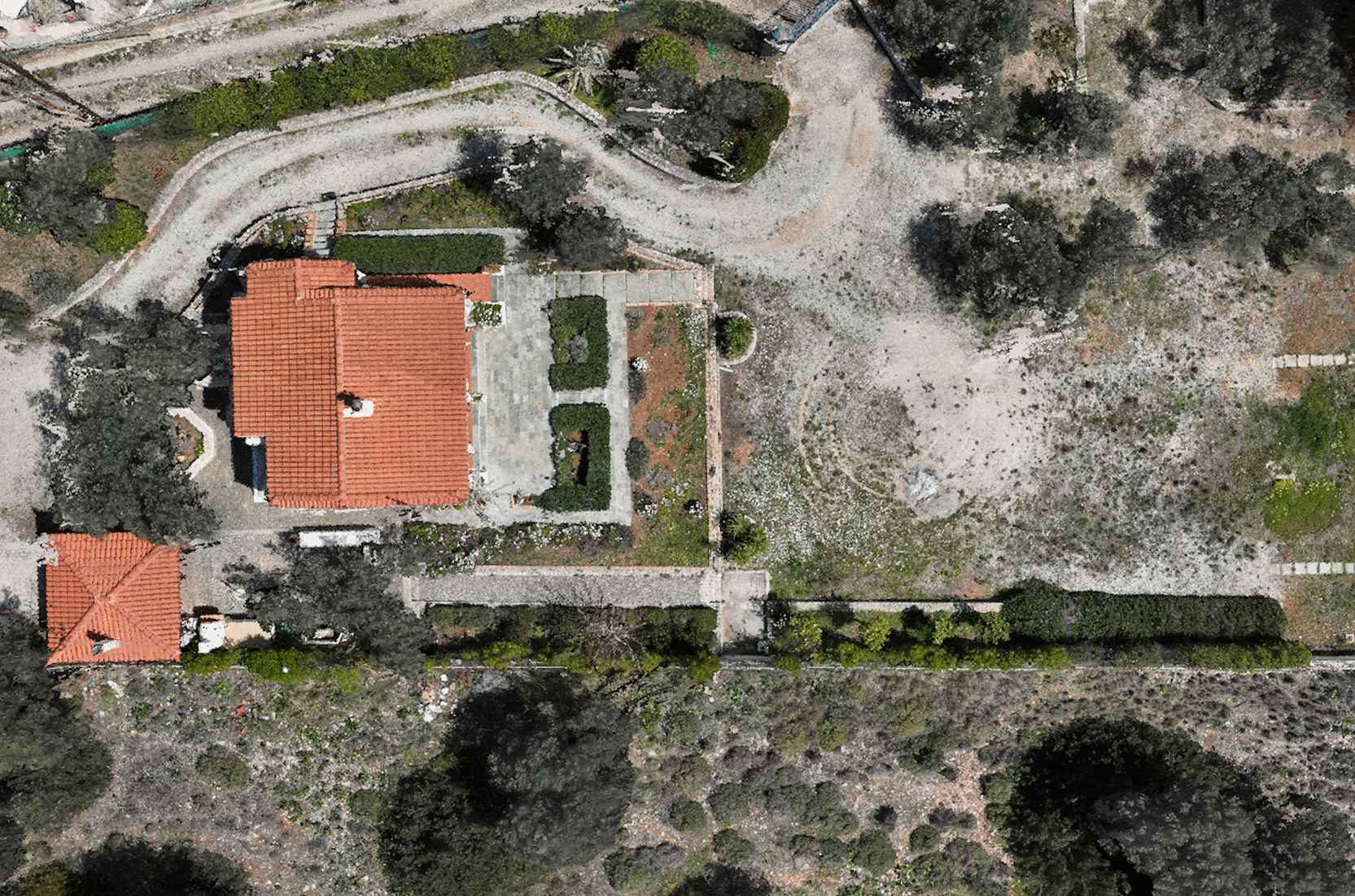
Figure 9. High-resolution orthomosaic detail (GSD ≈ 0.5 cm/pixel) enabled by centimetre-accurate georeferencing.
7. Vegetation indices and precision-agriculture services
RFSAT centimetre-accurate positioning accuracy and multispectral products feed a family of GNSS-enabled precision-agriculture services that were developed by other AgriBIT consortium partners, led by AGROAPPS, with contributions from AGENSO, AGRICOLUS, INOV and ENG, and delivered and visualised through the project’s collaborative platform, developed by ENG.23, 24 These services are exposed through a cross-visualisation dashboard (Figure 10) that aggregates parcels, activities, early-warning charts and service outputs for the farmer.
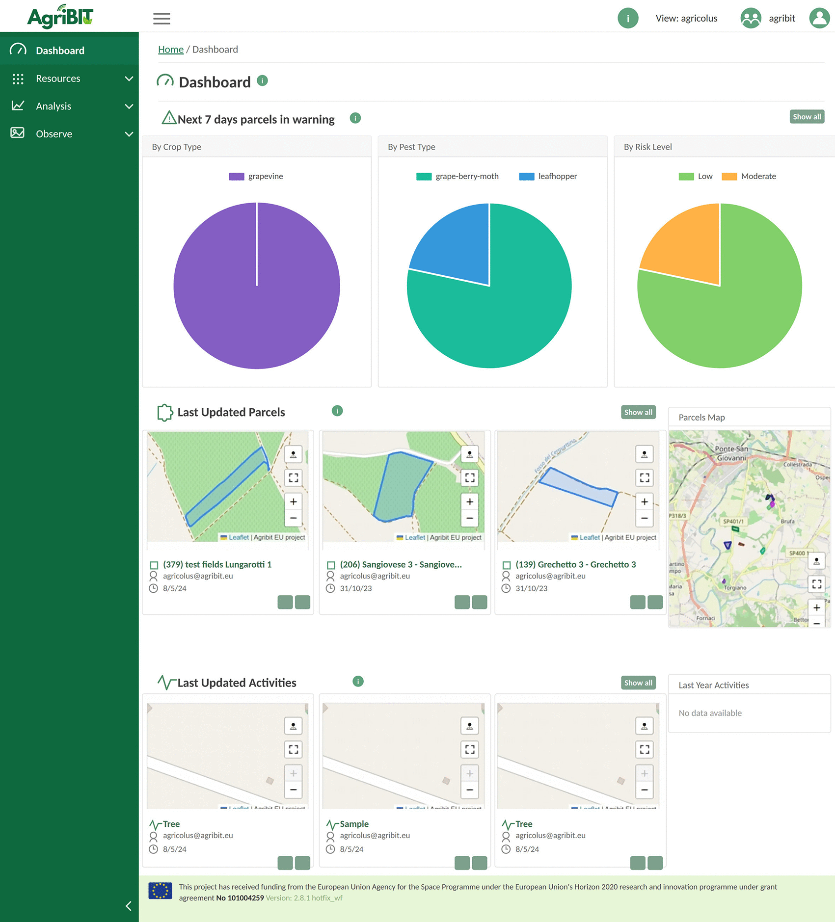
Figure 10. Cross-visualisation dashboard aggregating parcels, activities, early-warning charts and service outputs for the farmer; developed by AgriBIT partners, with platform provided by ENG.
The crop-growth-monitoring service delivers vegetation indices tailored to field and tree crops, including OSAVI (computed from Sentinel-2 imagery), CRI1 and ARI, from satellite multispectral data and UAV imagery, published as web-map heat-map layers (10 m for OSAVI, 20 m for CRI1 and ARI). NDVI maps derived from the UAV’s NIR band highlight within-field variability: in a typical olive-orchard product, red areas indicate dry, low-vigour ground while green areas mark healthy tree canopies (Figure 11).
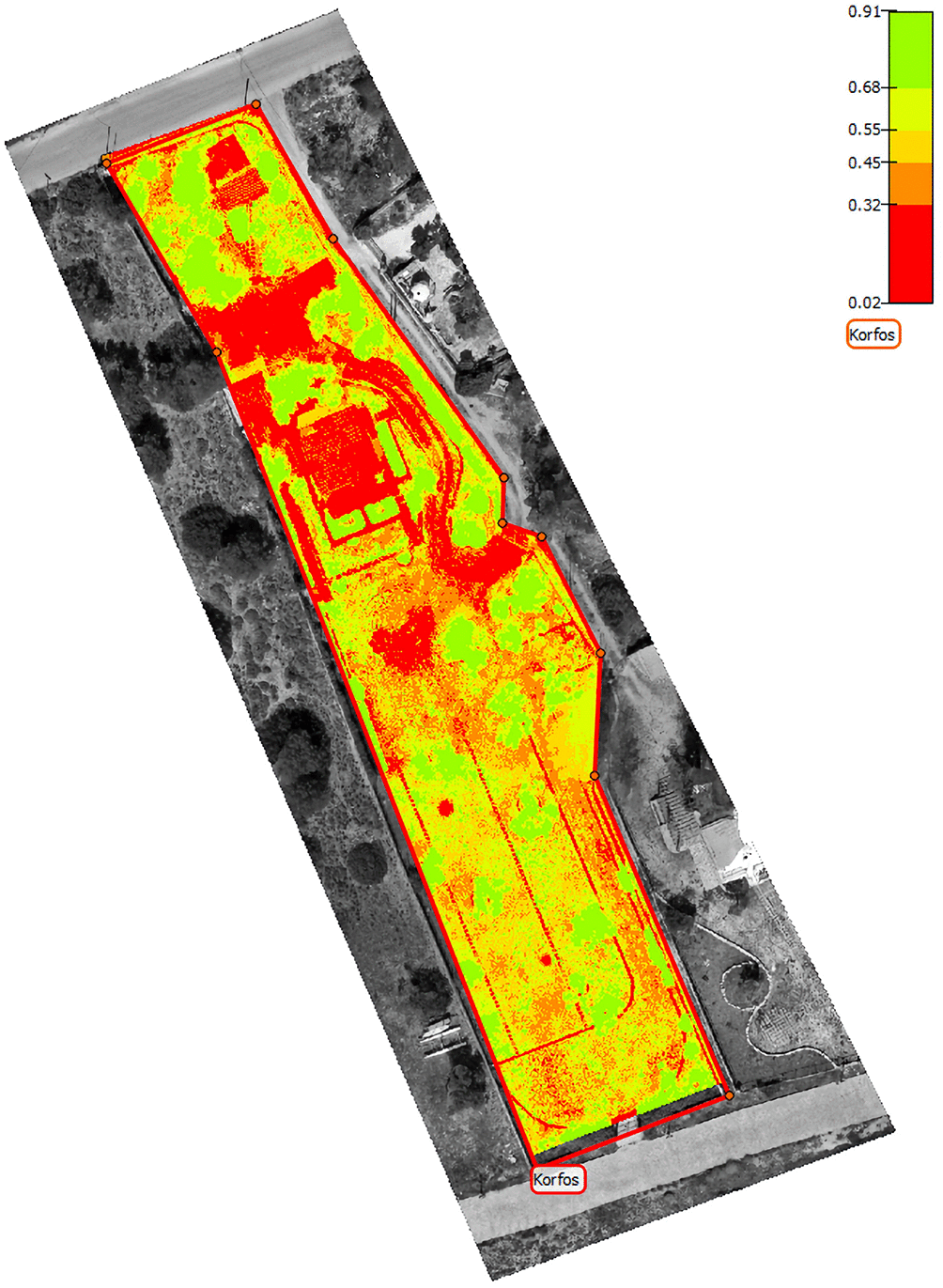
Figure 11. Example NDVI index map of a pilot field; red indicates dry/low-vigour ground and green indicate healthy tree canopies.
The crop-yield-estimation service furnishes daily yield estimates that reflect within-field heterogeneity, together with seasonal forecasts, driven by the AgroApps Weather Intelligence Engine, spanning twelve yield values across climatic scenarios (RCP2.6, RCP4.5 and RCP8.5) representing different greenhouse-gas concentration pathways shown in Figure 12. The climate-and-weather service provides high-resolution, hourly seven-day forecasts, updated twice daily, of air temperature and humidity at 2 m, wind at 10 m, accumulated precipitation, reference evapotranspiration, leaf wetness, hail events, solar radiation, cloud cover and mean sea-level pressure, helping farmers schedule field operations. The tillage- and irrigation-scheduling services, both built on the AquaCrop model, translate soil-moisture and gravimetric analyses into parcel-specific tillage-condition and topsoil (30 cm) moisture maps that are evaluated daily.24
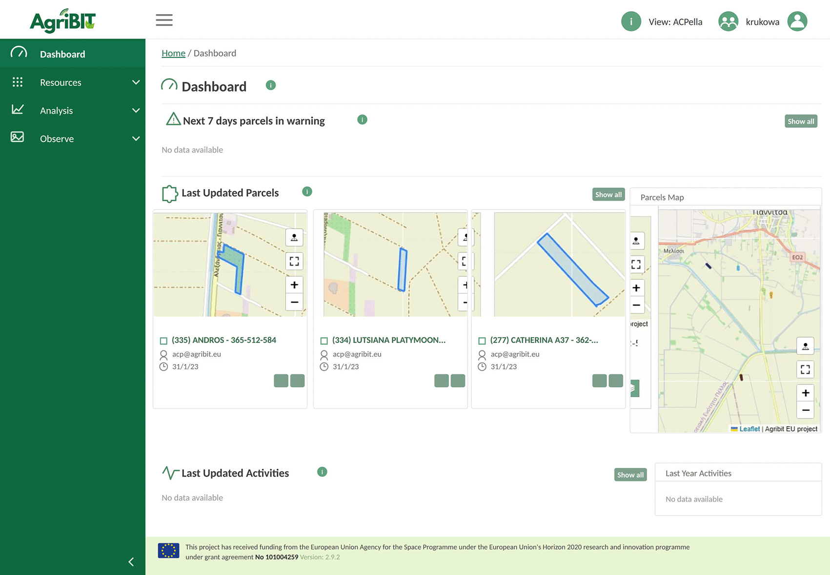
Figure 12. Vegetation-index and reflectance products delivered through the crop-growth-monitoring service (a GNSS-enabled service developed by AgriBIT partners).
Underpinning the whole bundle are three GNSS enablers that RFSAT centimetre-accurate positioning makes possible: a boundary-extraction enabler (the Demarcator app) that defines field borders and points of interest, a route-planning enabler (the LightBar app) that computes optimal guidance routes for autonomous aerial and ground vehicles, and a data-acquisition enabler that gathers geo-referenced sensor data. As detailed in the integrated-services deliverable D5.6,25 these enablers and the seven services are stitched together by an ENG-developed integration platform built on a flow-based data pipeline (Apache NiFi) with MongoDB geospatial store and Big-Data-Analytics dashboard, to allow every service to consume consistent, centimetre-referenced view of the field.
The prescription-mapping service (Figure 13), likewise part of the partner-developed service bundle, supports Variable-Rate Application (VRA): from farmer-supplied soil analyses per management zone and EO data, it derives vegetation zones and nutrient-requirement maps that drive fertilisation advice and variable-rate spraying. A practical concern when publishing centimetre-accurate products is that common GIS platforms (Google Maps, OpenStreetMap) use WGS-84 and metre-level base maps; to avoid losing accuracy, the full processing chain is performed in local datums and only the final products are oriented to the GIS visualisation datum. Locally deployed RTK ground stations, feeding corrections to all GNSS-enabled devices, give additional confidence that every product is accurately co-registered.
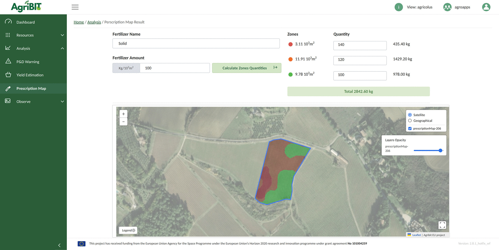
Figure 13. Prescription mapping: management zones and nutrient-requirement maps supporting Variable-Rate Application; a GNSS-enabled service developed by AgriBIT partners.
8. IOT Monitoring and the digital twin
Remote-sensing component is complemented by an IoT monitoring infrastructure of environmental and microclimatic sensors deployed across the fields. Originally developed within AgriBIT and now being upgraded within ENACT,4 the platform continuously collects weather, soil and environmental parameters together with crop-development indicators. Fusing these in-situ observations with georeferenced remote-sensing products creates a comprehensive digital twin of the agricultural environment: a spatially and temporally coherent model in which every measurement shares the same centimetre-accurate reference frame. The digital twin underpins the PA services above and provides substrate on which analytics operate, letting operators query current and historical state of each parcel and reason about interventions before they are applied in the field.
9. AI-based crop-health analytics
Advanced AI and machine-learning techniques are applied to the integrated datasets to automatically identify and precisely locate crop anomalies — water stress, insufficient irrigation, nutrient deficiencies, disease outbreaks, pest infestations and other indicators of degraded health. Automated analysis sharply reduces expertise and time required for field inspection while enabling early intervention and site-specific action, supporting precision irrigation, target agrochemical application, yield prediction, prescription-map generation and climate-smart management.
As a concrete example, multispectral images acquired autonomously at high altitude were processed with a deep convolutional SqueezeNet network19 pre-trained on about 55,000 images of tomato plants (half contaminated, half healthy) to detect fungal and pest damage. The approach demonstrated the feasibility of automated detection of tomato infections flagged as a serious issue at European level, reaching about 93% accuracy — the shortfall attributed mainly to limited reliable training data. RFSAT developed an online application, running under the MATLAB Application Server, that processes drone imagery to detect the tomato leaf miner (Tuta absoluta); the HTML version of the application can be accessed from https://www.rfsat.com/projects/H2020-AgriBIT/DL4AgriBIT.html,20 with severity- and density-analysis rules under development. Results, including assessment of infection risk and certainty alongside visual localisation of problem areas, are shown in Figure 14.
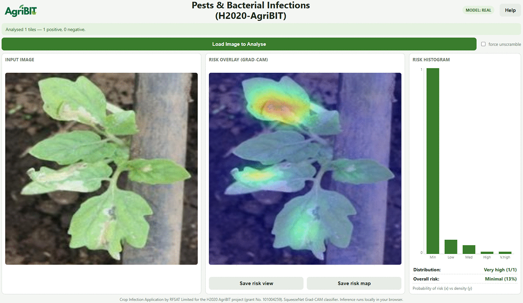
Figure 14. Deep-learning detection of pest/bacterial infection (tomato leaf miner, Tuta absoluta) from field imagery, with risk and severity assessment.
10. Conclusions and future work
This paper has presented an integrated precision-agriculture platform in which a low-cost, European-sourced, centimetre-accurate GNSS receiver serves as the backbone for multispectral remote sensing, IoT monitoring and AI analytics, fused into a georeferenced digital twin of the field. The receiver, built in modular form, fully meets both user requirements and system specifications, and its centimetre georeferencing was shown to be the decisive enabler of high-resolution 3D crop modelling, sub-centimetre orthomosaics and accurate vegetation-index and prescription products. The complete workflow was validated across orchards, vineyards and open-field crops in Greece, Portugal and Italy, where it improved monitoring accuracy, reduced input consumption and enhanced management decisions.
Future work, largely within the ENACT project, will upgrade the IoT infrastructure and extend the digital twin, refine the AI analytics with larger and more reliable training datasets, and broaden pest- and disease-detection coverage beyond the current tomato use case. On the hardware side, a new custom PCB will be designed for LAN, Wi-Fi, Bluetooth, USB and battery-powered variants with different ingress-protection levels; further antenna types (patch, helix, active and passive) will be evaluated for open-sky, urban-canyon and mixed environments; and LoRa or ZigBee links will be added for areas without cellular coverage. Together these developments aim to make climate-smart, resilient and resource-efficient farming practical at scale.
Ethics and consent
Ethical approval and consent were not required for this work.
Data availability
The 3D models mentioned in this article have been derived from aerial drone images collected over the military naval base in Scaramanga in Greece, as being a security restricted area, data from such surveillance cannot be made available via Open Access. Other drone surveillance areas concern data collected over private properties with permission granted only during and for the purpose of work in the relevant project, hence data availability via Open Access is subject to the explicit consent of the respective property owners. Interested readers are may contact the authors to request access to such a data, subject to permission from data owners.
Acknowledgment
The AgriBIT project received funding from the EU Horizon 2020 research and innovation programme (Grant Agreement No. 101004259). The authors thank the AgriBIT consortium partners, mainly AGROAPPS, AGENSO, AGRICOLUS, INOV and ENG, whose GNSS-enabled services and collaborative platform are illustrated here, and acknowledge the ongoing ENACT project (Grant Agreement No. 101157151), which supports the continued development of the IoT and analytics components described.
References
- 1.
AgriBIT project.
Reference Source
- 2.
AgriBIT on CORDIS (EU Horizon 2020).
Reference Source
- 3.
European Union Agency for the Space Programme (EUSPA).
Reference Source
- 4.
ENACT project, Horizon Europe research and innovation programme. Reference Source
- 5.
Copernicus/Sentinel-2.
Reference Source
- 6.
USGS Landsat 8.
Reference Source
- 7.
EOS Crop Monitoring.
Reference Source
- 8.
CropSAT/Dataväxt.
Reference Source
- 9.
HEXAGON Geosystems (NTRIP/RTK).
Reference Source
- 10.
DJI D-RTK 2 ground station.
Reference Source
- 11.
EOS Arrow Gold GNSS receiver.
http
- 12.
u-blox ZED-F9P/ZED-F9R modules.
Reference Source
- 13.
Quectel BG95 LTE modem.
Reference Source
- 14.
Espressif ESP32.
Reference Source
- 15.
NMEA-0183 protocol.
Reference Source
- 16.
ISO 11783-9: Tractor ECU.
Reference Source
- 17.
DJI Mavic 3 Multispectral.
Reference Source
- 18.
Parrot Sequoia+ multispectral camera.
Reference Source
- 19.
Iandola FN, et al.:
SqueezeNet: AlexNet-level accuracy with 50× fewer parameters.
arXiv:1602.07360
2016:
Reference Source
- 20.
RFSAT DL4AgriBIT online detection application.
http
- 21.
FP7-AF3 project on CORDIS:
Reference Source
- 22.
AgriBIT Deliverable D3.3:
“GNSS receiver architecture and baseline prototype” (WP3, Task 3.2), RFSAT (lead) and AGENSO.2023.
- 23.
AgriBIT collaborative platform (ENG):
Reference Source
- 24.
AgriBIT Deliverable D4.3:
“GNSS enablers and GNSS-enabled services (2nd release),” AGROAPPS (lead) with RFSAT, AGENSO, AGRICOLUS, INOV and ENG.2023.
Reference Source
- 25.
AgriBIT Deliverable D5.6:
“Integrated AgriBIT services” (WP5, Task T5.2), AGROAPPS (lead) with ENG, RFSAT and AGENSO.2024.
Reference Source