Introduction
New correlations
We report a remarkable correlation between the strike of major transform faults around the world and those of orogens and related contractional structures on adjacent continental margins. A striking characteristic of the orogens correlating with major transform faults is that they consistently strike highly oblique to orthogonal to the rift and mid-ocean ridge and parallel to the transform faults that offset the rift and mid-ocean ridge (Figure 1). Since the orogens are consistently older than the rifts and transforms with which they correlate (Figure 1), they are therefore proposed to have played a central role in controlling the formation of the transform faults and in forcing the rift to step sideways and/or in delaying or preventing continental breakup, acting as potential barriers to rifting.
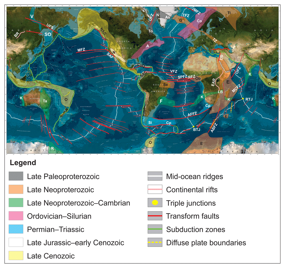
Figure 1. World topographic and bathymetric map showing the location and extent of the proposed orogenic bridges, related orogens (colored by age of last deformation events), and associated major transform faults (except the Timanian orogenic bridge in the Fram Strait).
The diffuse plate boundaries in the southwestern Indian Ocean are from Chu and Gordon (1999). The basemap is from Jakobsson et al. (2004). Abbreviations: A: Appalachian Orogen; AFFZ: Agulhas–Falkland fault zone; As: Ammassalik Belt; BR: Baikal Rift; BTJ: Bouvet Triple Junction; Ca: Cape Fold Belt; Co: Caledonian Orogen; CuO: Cuban Orogen; DS: Dead Sea Transform; E: East African–Antarctica Orogen; EAR: East African Rift; F: Dom Feliciano Belt; G: Greenland–Iceland–Faroe Ridge; JMFZ: Jan Mayen fault zone; K: Kuunga Orogen; LB: Lurio Belt; MCFZ: Marie Celeste fault zone; MFZ: Mendocino fault zone; N: Nagssugtoqidian Orogen; NAC: North American Cordillera; O: Oceanides; Ob: Oubangides/Central African Orogen; OFZ: Owen fault zone; R: Ross Orogen; RFZ: Romanche fault zone; RTJ: Rodrigues Triple Junction; SAC: South African Cordillera in Colombia and Venezuela; SAF: San Andreas fault; Se: Sergipano Belt; Si: Sierra de la Ventana Fold-and-Thrust Belt; SO: Sea of Okhotsk; SPFZ: Saint Paul fault zone; Ta: Tasman–Delamerian–New England–Lachlan–Thompson–Mosman Orogen; TFZ: Tjörnes fault zone; Ti: Timanian Orogen; To: Torngat Orogen; TZ: Tornquist Zone; UFS: Ulakhan fault system; UFZ: Ungava fault zone; V: Verkhoyansk Fold-and-Thrust Belt; VFZ: Vema fault zone.
It was possible to establish this correlation in great part due to major improvements in the quality of seismic imaging and partly to our ability to now identify major shear zones (e.g., Bird et al., 2016; Fazlikhani et al., 2017; Hedin et al., 2016; Lenhart et al., 2019; Phillips et al., 2016; Ye et al., 2020), major thrust systems, and related contractional structures on seismic data (e.g., Koehl, 2020; Koehl, 2021; Koehl et al., 2022; Koehl et al., 2023a; Koehl et al., 2023b; Morley et al., 2017). Although mylonitic detachments have been identified for quite some time on seismic data (e.g., Christensen, 1965; Fountain et al., 1984; Hurich et al., 1985), the spectrum of contractional structures correlated from onshore outcrops to subsurface seismic data was significantly broadened very recently and now includes stacks of thrust sheets separated by mylonitic shear zones, contractional duplexes, antiformal thrust stacks, and asymmetric (up to recumbent and isoclinal) folds within shear zones (Koehl, 2021; Koehl et al., 2022; Koehl et al., 2023a).
Major issues with plate tectonics
Plate tectonics, which evolved from the Wegener’s Continental Drift Theory (1929), governs our vision of the evolution of Earth’s surface over time. Surface movements are related to deep processes, which are thought to be a key component of present-day plate tectonics (e.g., Burke & Torsvik, 2004). However, deep processes do not explain all data, in particular offshore areas of anomalously thick crust (e.g., Iceland). Such crust typically displays continental affinities (e.g., Foulger et al., 2020a). In addition, offshore thickened slices of crust, e.g., the Walvis and Rio Grande ridges, commonly strike oblique to nearby major transform faults. Since transform faults are direct indicators of the direction of spreading at mid-ocean ridges and therefore of plate movements, should anomalously thick crustal ridges comprise deep mafic igneous rocks built by static magma reservoirs, they would be expected to lie parallel to the transform faults. This is rarely the case.
Some major transform faults in the Atlantic and Indian oceans, e.g., the Romanche and Andrew Bain fault zones (Figure 1), do not conform with typical transform fault geometries. Instead, they comprise multiple segments (Ligi et al., 2002) that bound slivers of lithosphere that switched movement direction as seafloor spreading progressed (the “oscillatory spreading” of Bonatti and Crane, 1982). These faults show the largest age offset of the mid-ocean ridges they truncate and most likely have a different thermal structure, i.e., they probably also affect cold lithosphere (Ligi et al., 2002). In addition, they do not lie on small circles about the Eulerian pole of rotation (Cande et al., 1988; Chu & Gordon, 1999; Sclater et al., 2005; Shaw & Cande, 1990), so they do not coincide well with the spreading direction.
Large areas of (hyper-) extended continental crust have now been discovered offshore. New offshore continental blocks generally not included in full-plate-tectonic reconstructions (e.g., Cao et al., 2021; Domeier & Torsvik, 2014; Merdith et al., 2021; Young et al., 2019) include the Lomonosov Ridge (Knudsen et al., 2017; Rekant et al., 2019), the Alpha–Mendeleev Ridge (Foulger et al., 2023 submitted; Jackson & Chian, 2019), the De Long Islands block (Ershova et al., 2016), the Laptev Sea (Shipilov et al., 2021), portions of the Eurasian Basin (Jokat & Schmidt-Aursch, 2007), and the Chukchi Borderlands in the Arctic Ocean (Brumley et al., 2015; O’Brien et al., 2016). In the northeastern Atlantic Ocean, they include the Hovgård and East Greenland ridges (Dumais et al., 2020), Icelandia (Foulger et al., 2020a; Geoffroy et al., 2022a), the Jan Mayen Microcontinent Complex (Bott, 1985; Johnson & Heezen, 1967; Schiffer et al., 2018), and the Rockall Plateau and Rockall Bank (Dickin, 1992; Roberts et al., 1973), and the Davis Strait High in the northwestern Atlantic Ocean (Dafoe et al., 2022). In the Central Atlantic Ocean, such blocks include the Newfoundland and Iberian margins (Lymer et al., 2019; Shillington et al., 2006). In the South Atlantic, blocks of continental affinities include the Walvis–Rio Grande Ridge (Fromm et al., 2017a; Fromm et al., 2017b; Ventura Santos et al., 2019), a wide portion of the continental margin off Namibia (Geoffroy et al., 2022b), and Maurice Ewing Bank and the Falkland Plateau (Chemale Jr. et al., 2018; Stanca et al., 2022). In the Indian Ocean, continental affinities are probable for the Mozambique and Madagascar ridges (Klimke et al., 2018; Ryzhova et al., 2022; Sato et al., 2022), the Del Cano Rise (Sato et al., 2022), and Mauritia (Torsvik et al., 2013), and for Zealandia in the southwestern Pacific Ocean (Luyendyk, 1995; Mortimer et al., 2006; Mortimer et al., 2017).
The issues around transform faults and relatively recently discovered offshore continental blocks present major issues for past and present-day plate tectonics, the formation of oceanic crust at mid-ocean ridges, and the repeated opening and closing of oceans between the continents (e.g., opening and closing of Iapetus between Laurentia and Svalbard followed by the opening of the northeastern Atlantic Ocean). They imply that current models are overly simplistic and the degree to which the basic model should be revised is in need of consideration. We propose a new approach and views that can address these issues. Notably, we propose that major transform faults form along rift-orthogonal orogens and that RRR triple junctions form at the intersection of (at least) two orogens. The new approach also helps predict the future tectonic evolution of Earth’s surface (e.g., propagation and steps in rift axis) and test the existence of paleo-transform faults. Overall, we suggest less dynamism in paleo-plate tectonics, thus both partly in agreement with Continental Drift and modern plate tectonics, and partly with the Land Bridge Theory.
The orogenic bridge theory (OrBiT)
Every major transform fault on Earth strikes parallel to an orogen and related structures on one or several adjacent rifted margins. By “major transform faults” we mean transform faults showing offset of active mid-ocean ridges greater than a few kilometers. By “orogens”, we mean belts deformed intensely during contractional strain for several tens of million years leading to the development of kilometer-wide, hundreds of kilometers long, kilometer-thick structures such as thrust faults, shear zones, folds, and other related fabrics.
This relationship has received little attention despite the potential ground-breaking implications it may have. This may be because of complexity (e.g., the need for interdisciplinary science) and inhomogeneity (e.g., conflicting opinions and approaches) in the geological literature. Contributing issues may be outdated, faulty assumptions about the geology of specific areas, incomplete data particularly from remote areas (e.g., the Arctic, Fram Strait, and Davis Strait), or areas of poor exposure that are covered by young basins and sediments. Geophysical data may also be limited in extent and/or quality, especially in areas where seismic data are more challenging to acquire (e.g., onshore central Europe).
In the present contribution, we review the relationship between major transform faults and preexisting orogens on adjacent margins across all oceans. The orogenic bridge theory (OrBiT) states that the style of continental rifting (e.g., orthogonal, oblique, transform) is intrinsically controlled by preexisting orogens and that, notably, the occurrence of orogens perpendicular to the opening rift result in the development of orogenic bridges (strong barriers), which force the rift to step or stop. Preexisting orogenic belts striking parallel to a propagating rift will facilitate the opening and propagation of the rift and control the strike and geometry of structures formed during rifting. These include dominantly extensional structures such as brittle normal faults and ductile detachments bounding sedimentary basins and basement horsts and metamorphic core complexes (Figure 2a). This endmember has been in several papers (e.g., Chenin et al., 2015; Li et al., 2023; Osagiede et al., 2020; Péron-Pinvidic & Osmundsen, 2020; Péron-Pinvidic et al., 2022; Salazar-Mora et al., 2018).
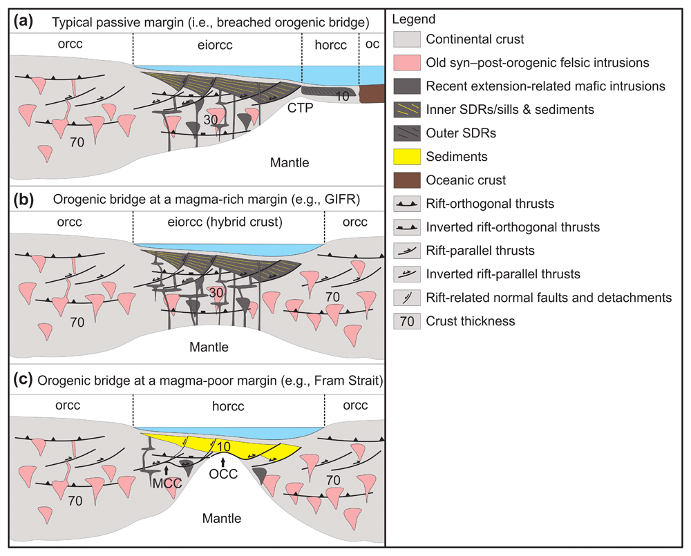
Figure 2. Sketch illustrating different types of crusts.
(a) Typical rifted margin with thinned continental crust, SDRs, and oceanic crust (based on Geoffroy et al., 2022b). (b) Orogenic bridge at a magma-rich margin, e.g., the GIFR, where large amounts of mafic magma intruded thinned orogenic continental crust, thus producing hybrid continental crust (i.e., extensively intruded by mafic magma). (c) Orogenic bridge at a magma-poor margin, e.g., the Fram Strait, where metamorphic and oceanic core complexes formed both orthogonal (parallel to the section) and parallel (annotated on the sketch) to the active rift. In both (b) and (c), preexisting thrust systems parallel and perpendicular to the rift thinned the continental crust. This implies that the regions studied here were affected by at least two (non-coeval) orogenic events whose main stress were perpendicular to one another. Orogens (in the present case parallel to the propagating rift) generally show a dominant transport direction (i.e., the orogens are generally asymmetric rather than symmetric) and, therefore, the internal crustal asymmetry of continental margins in (b) and (c) is rather the rule than the exception. Abbreviations: CTP: Crustal Thin Point; eiorcc: extended and intruded orogenic continental crust; horcc: hyperextended orogenic continental crust; MCC: metamorphic core complex; oc: oceanic crust; OCC: oceanic core complex; orcc: orogenic continental crust; SDRs: Seaward-Dipping Reflectors.
Conversely, orogens striking highly oblique to perpendicular to a propagating rift will act as barriers and significantly delay rift propagation or prevent the rift from opening in a linear fashion or from propagating. The term “orogenic bridge” refers to the orogenically thickened crust part of a rift-orthogonal orogen, which was (hyper-) extended during rifting (Figure 2b and c). The term “bridge” is used in reference to the land bridges (also called Isthmian Links) inferred by the Land Bridge Theory to explain similar fauna and flora on separate continents (e.g., Gregory, 1929; Schuchert, 1932; von Ihering, 1931; Willis, 1932). All those sites match the location of orogenic bridge sites that we propose here, thus suggesting that plate tectonics and the Land Bridge Theory are not completely incompatible (Figure 1). Should rifting continue long enough, rift-orthogonal orogens will force the rift to reorient locally (e.g., Molnar et al., 2017) to accommodate a major sideway step before propagating further or merging two propagating rifts on either side of an orogenic bridge. An example is the parallel northeastern Atlantic and Arctic rifts that are linked via the oblique Fram Strait rift, which opened tens of millions of years after the rifts formed. As a result, rift-orthogonal orogens are thought to localize the formation of major (> a few kilometers lateral offset) transform faults.
Interestingly, all the land bridges (Isthmian Links) postulated by the Land Bridge Theory (e.g., Gregory, 1929; Schuchert, 1932; von Ihering, 1931; Willis, 1932) correlate with orogenic bridges proposed in the present study (Figure 1). The OrBiT therefore gives a curious new perspective to the Land Bridge Theory, reconciling it with Wegener’s Continental Drift Theory and modern plate tectonics by suggesting that much of the submarine area around the globe consist of (hyper-) extended and/or extensively intruded (i.e., hybrid) orogenic continental crust (Figure 2b and c). Rift-related (hyper-) extension of continental crust, the intrusion of continental crust by large volumes of mafic magma at magma-rich rift segments, and the occurrence of thickened orogenic crust with structures striking orthogonal to propagating rifts may thus together explain present-day datasets and reconcile concepts that were once competing theories. Land bridges were once proposed by knowledgeable geoscientists in the early 20th Century. It is therefore not surprising that it may hold some truth after all.
The OrBiT highlights a new relationship between major transform faults and rift-orthogonal orogens by demonstrating the occurrence of ridges of orogenically-thickened, (hyper-) extended continental crust (orogenic bridges) striking perpendicular to propagating rifts offshore. It suggests that the amount of oceanic crust on Earth and, consequently, the amount of lateral movement by the continental blocks over the history of the Earth are currently overestimated. The OrBiT also potentially enables the prediction of the location of future rift steps and rift opening.
Previous work
Large-scale relationships in the Atlantic Ocean were discussed previously by Lundin and Doré (2005). They noted a coincidence of Neoproterozoic–Phanerozoic fold-and-thrust belts with the volcanic segments of the continental rifted margins. However, the Central African Orogen/Oubangides branch of the Pan African Orogeny, which strikes E–W and separates the Sahara meta-craton from the Congo craton (e.g., Kouémo et al., 2014; Kröner & Stern, 2004; Toteu et al., 2022) and extends into northeastern Brazil as the Sergipano Belt (D’el-Rey Silva, 1999; Oliveira et al., 2006; Oliveira et al., 2010; Oliveira et al., 2015; Figure 1) was not included. With the addition of this orogen, the relationship of volcanic margins with preexisting orogens and of non-volcanic margins with the absence of preexisting orogens becomes tenuous. Another disagreement is the occurrence of the Timanian Orogen at the magma-poor segment of the northeastern Atlantic rift in the Fram Strait along the western Svalbard–Barents Sea margin and the northern Greenland margin (Estrada et al., 2018a; Klitzke et al., 2019; Koehl, 2020; Koehl et al., 2022; Koehl et al., 2023a; Koehl, 2024 awaiting peer review; Rosa et al., 2016).
Lundin et al. (2022) further highlighted the relationship of preexisting orogens with the location of major transform faults, showing that the continental crust at transform margins is on average thicker than the continental crust at rifted margins. This supports the orogenically-thickened character of the continental crust at major transform margins (e.g., Fram Strait). Other studies suggested that oblique and associated major transform fault systems may result in asymmetric hyperextended margins (e.g., Le Pourhiet et al., 2017). However, these studies did not address the causes of major rift offsets or steps.
Discussion
Extent of continental vs oceanic crust
Potential Orogenic Bridges (OrBs)
Potential orogenic bridges we discuss include the Fram Strait (Dumais et al., 2020; Koehl, 2020; Koehl, unpublished manuscript; Koehl et al., 2021), the Greenland–Iceland–Faroe Ridge (GIFR; Foulger et al., 2003; Foulger et al., 2020a; Foulger et al., 2020b; Foulger, 2006; Geoffroy et al., 2022a; Torsvik et al., 2015), and the Davis Strait (Dafoe et al., 2022; Dalhoff et al., 2006) in the North Atlantic region. We also discuss Maurice Ewing Bank and the Falkland Plateau (Chemale Jr. et al., 2018; Stanca et al., 2022) in the South Atlantic, and the Mozambique, Madagascar, and Gunnerus ridges and the Del Cano Rise (Klimke et al., 2018; Leitchenko et al., 2008; Sato et al., 2022) in the Indian Ocean.
Continuous Orogenic Bridges (OrBs)
Timanian orogenic bridge
The recent discovery of continuous, late Neoproterozoic Timanian thrust systems from northwestern Russia to the Svalbard Archipelago throughout the Barents Sea has dramatically changed our perception of pre-Caledonian tectonic history in this entire region (Koehl, 2020; Koehl et al., 2022; Koehl et al., 2023a; Koehl et al., 2023b; Koehl, 2024 awaiting peer review; Figure 3). Some of these structures can be traced across the Fram Strait (e.g., in the Hovgård Ridge; Koehl, 2020 pp. 163–166, Koehl, unpublished manuscript) into blocks of continental crust that are now known to be fully attached to Laurentia and Greenland’s continental crust (Dumais et al., 2020; Figure 3). New magnetic data by Dumais et al. (2020) and seismic reflection data between the Molloy and Spitsbergen fault zones (Koehl, 2020 pp. 167–180, Koehl, unpublished manuscript; Koehl et al., 2021 pp. 9–20; Figure 3) show that there is little to no oceanic crust sensu stricto along the Molloy Ridge. Furthermore, Timanian subduction-related magmatism was recently identified in northern Greenland (Estrada et al., 2018a; Rosa et al., 2016), Arctic Canada (Estrada et al., 2018b), and the Lomonosov Ridge (Rekant et al., 2019; Figure 3), further supporting the continuation of the Timanian Orogen across the northeastern Atlantic–Arctic rift.
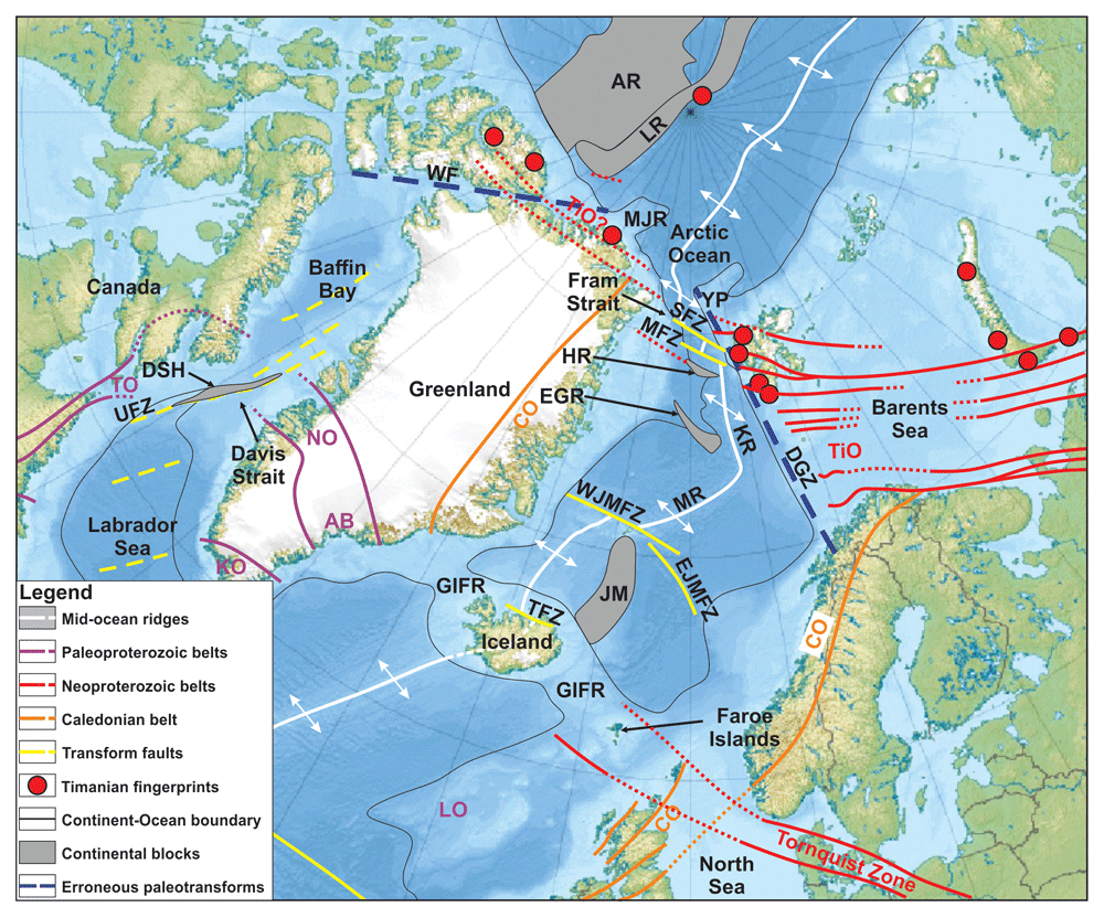
Figure 3. International Bathymetric Map of the Arctic Ocean showing the continent–ocean boundary, continental blocks, major orogens and associated thrust faults, and major transform faults in Arctic regions.
Three orogenic bridges are proposed in the area: the Timanian orogenic bridge in the Fram Strait, the Nagssugtoqidian–Torngat orogenic bridge in the Davis Strait, and the Greenland–Iceland–Faroe orogenic bridge between Greenland, Iceland, and the Faroe Islands (the GIFR). Basemap is from Jakobsson et al. (2012). Abbreviations: AB: Ammassalik Belt; AR: Alpha–Mendeleev Ridge; CO: Caledonian Orogen; DGZ: De Geer Zone; DSH: Davis Strait High; EGR: East Greenland Ridge; EJMFZ: East Jan Mayen fault zone; HR: Hovgård Ridge; JM: Jan Mayen continental crust; KO: Ketilidian Orogen; KR: Knipovich Ridge; LO: Laxfordian Orogen; LR: Lomonosov Ridge; MFZ: Molloy Fault Zone; MJR: Morris Jesup Rise; MR: Mohns Ridge; NO: Nagssugtoqidian Orogen; SFZ: Spitsbergen Fault Zone; TiO: Timanian Orogen; TO: Torngat Orogen; UFZ: Ungava Fault Zone; WF: Wegener Fault; WJMFZ: West Jan Mayen fault zone; YP: Yermak Plateau.
In addition, most studies of seismic reflection data west of Svalbard show that the margin lacks evidence of strike-slip movements (Austegard et al., 1988; Eiken, 1994; Eiken & Austegard, 1987; Gabrielsen et al., 1990; Lasabuda et al., 2018; Riis & Vollset, 1988). This is surprising given the expectation of a major N–S-striking paleo-transform there, the so-called De Geer Zone (Figure 3), which has been inferred on the basis of the linear geometry of the Svalbard–Barents Sea margin and conjugate margin in northern Greenland (du Toit, 1937; Harland, 1961; Harland, 1967; Harland, 1969; Horsfield & Maton, 1970; Wegmann, 1948). Recent studies show that several late Neoproterozoic Timanian thrust systems extend past the speculated location of the early Cenozoic De Geer Zone without any lateral offset (Koehl, 2024 awaiting peer review). This suggests that Timanian thrusts may extend from northwestern Russia to northern Greenland thus forming a continuous orogenic bridge across the Fram Strait (Figure 3). The two active transform faults in the Fram Strait, the Molloy and Spitsbergen fault zones, strike parallel to and probably developed along preexisting Timanian thrusts (Koehl et al., 2021; Koehl, 2024 unpublished manuscript).
Nagssugtoqidian–Torngat orogenic bridge
The Davis Strait connects the Labrador Sea, which is undoubtedly partly underlain by oceanic crust (e.g., Oakey & Chalmers, 2012; Peace et al., 2016), and Baffin Bay, where the existence of oceanic crust is more speculative (e.g., Funck et al., 2012; Welford et al., 2018). Along the strait, a major transform fault, the Ungava Fault Zone (Chalmers & Pulvertaft, 2001; Dafoe et al., 2022; MacLean et al., 1982; Oakey & Chalmers, 2012) along which the mid-ocean ridge is believed to have stepped, flanks a basement high, the Davis Strait High, which was suggested to be of continental nature based on dredge samples (Dalhoff et al., 2006) and seismic reflection data (Dafoe et al., 2022).
On either side of the strait, numerous onshore studies have revealed well-developed Paleoproterozoic orogenic structures of the ENE–WSW-striking Nagssugtoqidian Orogen in western Greenland (Mengel et al., 1998; van Gool et al., 2002a) and of the N–S-striking Torngat Orogen in northeastern Canada (van Gool et al., 2002b; van Gool et al., 2005; Figure 1 and Figure 3). Despite being highly oblique, the two orogens are believed to merge with one another in the Davis Strait and to be part of the same (folded? Indented?) orogen. In northeastern Canada, the Torngat Orogen appears to curve into an ENE–WSW strike in northern Labrador–southeastern Baffin Island, thus potentially forming an arch hundreds of kilometers wide with the Nagssugtoqidian Orogen in map view (Figure 3).
This arch is interpreted as a potentially continuous orogenic bridge (Figure 3) given the continental nature of the Davis Strait High (Dafoe et al., 2022; Dalhoff et al., 2006). This is supported by consistent kinematics in both orogens, i.e., sinistral shear zones and top-SSE (i.e., hanging wall moving to the south-southeast) thrusts in the Nagssugtoqidian Orogen and sinistral shearing and top-east thrusting in the Torngat Orogen (Mengel et al., 1998; van Gool et al., 2002a; van Gool et al., 2002b; van Gool et al., 2005). The continuity character of the Nagssugtoqidian–Torngat orogenic bridge is consistent with the absence of apparent lateral offset of the orogen across the Ungava Fault Zone. This calls for further reexamination of movements along this major fault.
The Greenland–Iceland–Faroe Ridge orogenic bridge
The 25–40 km thick crust below the GIFR (Darbyshire et al., 1998) has long been interpreted as thick oceanic crust formed through the activity of a deep mantle plume, with magmatism initiating at ca. 62 Ma or 54 Ma or even 252 Ma depending on the model (e.g., Torsvik et al., 2015; White & McKenzie, 1995). The anomalously thick crust nevertheless suggests that a continental nature (alternatively a hybrid crust, i.e., continental crust extensive intruded by mafic magma) should be considered (Foulger et al., 2003; Foulger et al., 2020a; Foulger, 2006; Geoffroy et al., 2022a). Foulger et al. (2020a) suggested that the GIFR might represent a section of stretched, orogenically-thickened continental crust, which presented high resistance to rifting and continental breakup. They was suggested that this anomalous crust could be the northern continuation of the Caledonian Orogen in Scotland and might link with the Caledonides of southeastern Greenland.
This model is plausible considering the similarly abrupt (c. 90°) bend of the Scandinavian Caledonides in the southern Barents Sea (Gernigon & Brönner, 2012; Gernigon et al., 2014) from an overall NE–SW strike in Norway and Sweden (e.g., Corfu et al., 2014; Roberts, 2003) to a N–S trend in Svalbard (e.g., Harland et al., 1992; Manby, 1986; Witt-Nilsson et al., 1998). Other orogens worldwide show similar 90° bends (e.g., Verkhoyansk Orogen in northeastern Russia; Figure 1). However, this model neglects the Scandinavian Caledonides, which were proposed to represent the continuation of the southern Scottish Caledonides (e.g., Coward, 1990; Fossen, 2010; McClay et al., 1986; Norton et al., 1987).
If the Scottish Caledonides represent the continuation of the southeastern Greenland Caledonides, it is unclear how and where the Scandinavian Caledonides continue to the southwest. In addition, this model requires not one but two abrupt c. 90° bends of the Caledonian Orogen, and the required two bends of the Caledonian Orogen would have to be generated by overall NW–SE-oriented Cenozoic extension during rifting. This is unlikely because NW–SE extension is more likely to have inverted and overprinted NE–SW-striking Caledonian structures instead of deflecting them by 90°. Major post-Caledonian shear zones onshore southern and western Norway are now known to extend in a northeast–southwest strike offshore (Fazlikhani et al., 2017; Fossen & Hurich, 2005; Lenhart et al., 2019; Osagiede et al., 2020; Phillips et al., 2016; Serck et al., 2022) and to merge with their analogously striking counterparts in the northern UK (Bird et al., 2016; Coward et al., 1989; Platt & Cartwright, 1998).
An alternative source for orogenically thickened crust below the GIFR may be the Paleoproterozoic, WNW–ESE-striking Ammassalik Belt, the probable continuation of the Nagssugtoqidian Orogen in southeastern Greenland (Figure 1 and Figure 3; Bridgewater & Myers, 1979; Chadwick & Vasudev, 1989; Chadwick et al., 1989; van Gool et al., 2002b; van Gool et al., 2005). Major structures in the belt show top-SSW kinematics consistent with structures in the Nagssugtoqidian Orogen in western Greenland (Kalsbeek et al., 1993; van Gool et al., 2002b; van Gool et al., 2005). Other alternatives include the Ketilidian Orogen in southern Greenland (Chadwick et al., 2000; Garde et al., 1997; Garde et al., 2002) and the Laxfordian Orogen on the Rockall Plateau (Attfield, 1987; Dickin, 1992), but these occur further to the southwest. The coeval Ammassalik Belt is our preferred hypothesis (Figure 3).
In Europe, a possible candidate to explain crustal thickening in the GIFR is the WNW–ESE-striking Tornquist Zone, which extends from the Black Sea (Mikolajczak et al., 2019; Narkiewicz et al., 2015) to the southern North Sea (Kalani et al., 2020; Phillips et al., 2018). Available seismic reflection data in the central and northern North Sea and west of the Faroe Islands suggest that the Tornquist Zone may continue as far north as the Shetland Plateau (e.g., Bird et al., 2016; Fossen & Hurich, 2005; Gabrielsen et al., 2015; Koehl et al., unpublished manuscript; Serck et al., 2022). The Tornquist Zone accommodated significant contractional deformation and related crustal thickening as early as the Neoproterozoic during the closure of the Tornquist Ocean (Torsvik & Rehnström, 2003). The Tornquist Zone possibly consists of top-northeast (Abramovitz et al., 1999; Krzywiec et al., 2017; Lyngsie & Thybo, 2007; Mazur et al., 2015; Mazur et al., 2018) and top-SSW thrusts (Koehl et al., unpublished manuscript).
Both the Tornquist Zone in Europe and structures of the Ammassalik Belt in southeastern Greenland parallel the GIFR and the Tjörnes fault zone, a major right-lateral complex shear zone in northern Iceland that connects the Icelandic Northern Volcanic Zone and the Kolbeinsey Ridge (Einarsson, 1976; Einarsson, 1991; Khodayar, 2018; Khodayar & Björnsson, 2018; Rögnvaldsson et al., 1998; Young et al., 1985). We therefore propose that the GIFR represents a continuous orogenic bridge, which prevented full propagation of the mid-Atlantic rift. Further analysis of geophysical data from the GIFR and the North Sea and regional correlation of this major deformation zone would help clarify the impact of the Tornquist Zone on the crustal structure of the GIFR. Nevertheless, special attention should be given to the expression of Paleoproterozoic structures of the Ammassalik Belt on offshore seismic data because of their well constrained top-SSW kinematics and geometry onshore (e.g., Kalsbeek et al., 1993) and our present ability to identify deep-seated orogenic structures and thrust systems on seismic reflection data (e.g., Fazlikhani et al., 2022; Freeman et al., 1988; Hedin et al., 2016; Juhlin et al., 2016; Koehl et al., 2022; Koehl et al., 2023a; Platt & Cartwright, 1998).
Ruptured orogenic bridges
Numerous orogenic bridges were previously continuous and have now been ruptured by rifting. Here we discuss two notable examples – the late Paleozoic Cape Fold Belt in South Africa and its continuation into the Falkland Plateau and Maurice Ewing Bank off southeastern South America (Figure 4) and the late Neoproterozoic East African–Antarctica Orogen, which extends from the Arabian–Nubian Shield in the north to Dronning Maud Land in Antarctica in the south (Figure 5).
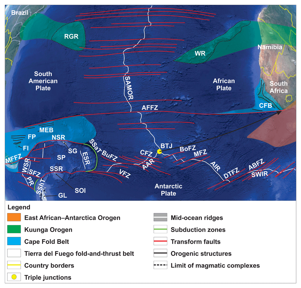
Figure 4. Topographic–bathymetric map of the South Atlantic Ocean showing the ruptured Cape Fold Belt orogenic bridge.
The black arrow links the Bouvet Triple Junction with the intersection of the Cape Fold Belt and East African–Antarctica Orogen prior to rifting. The orogenic structures of the Cape Fold Belt in the Falkland Islands, Falkland Plateau, and Maurice Ewing Bank are from Stanca et al. (2022). Those in South Africa are from Johnston (2000). Basemap is from © Google Earth. Abbreviations: AAR: America–Antarctic Ridge; ABFZ: Andrew Bain fault zone; AFFZ: Agulhas–Falkland fault zone; AIR: Atlantic–Indian Ridge; BoFZ: Bouvet fault zone; BuFZ: Bullard fault zone; BTJ: Bouvet Triple Junction; CFB: Cape Fold Belt; CFZ: Conrad fault zone; DTFZ: Du Toit fault zone; ESR: East Scotia Ridge; FI: Falkland Islands; FP: Falkland Plateau; GL: Graham Land; MEB: Maurice Ewing Bank; MFFZ: Magallanes–Fagnano Fault Zone; MFZ: Moshes fault zone; NSR: North Scotia Ridge; PR: Phoenix Ridge; RGR: Rio Grande Ridge; SAMOR: South Atlantic mid-ocean ridge; SFZ: Shackleton fault zone; SG: South Georgia; SP: Scotia Plate; SOI: South Orkney Islands; SSaT: South Sandwich Trench; SShT: South Shetland Trench; SSR: South Scotia Ridge; SWIR: Southwest Indian Ridge; VFZ: Vinogradov fault zone; WR: Walvis Ridge; WSR: West Scotia Ridge.
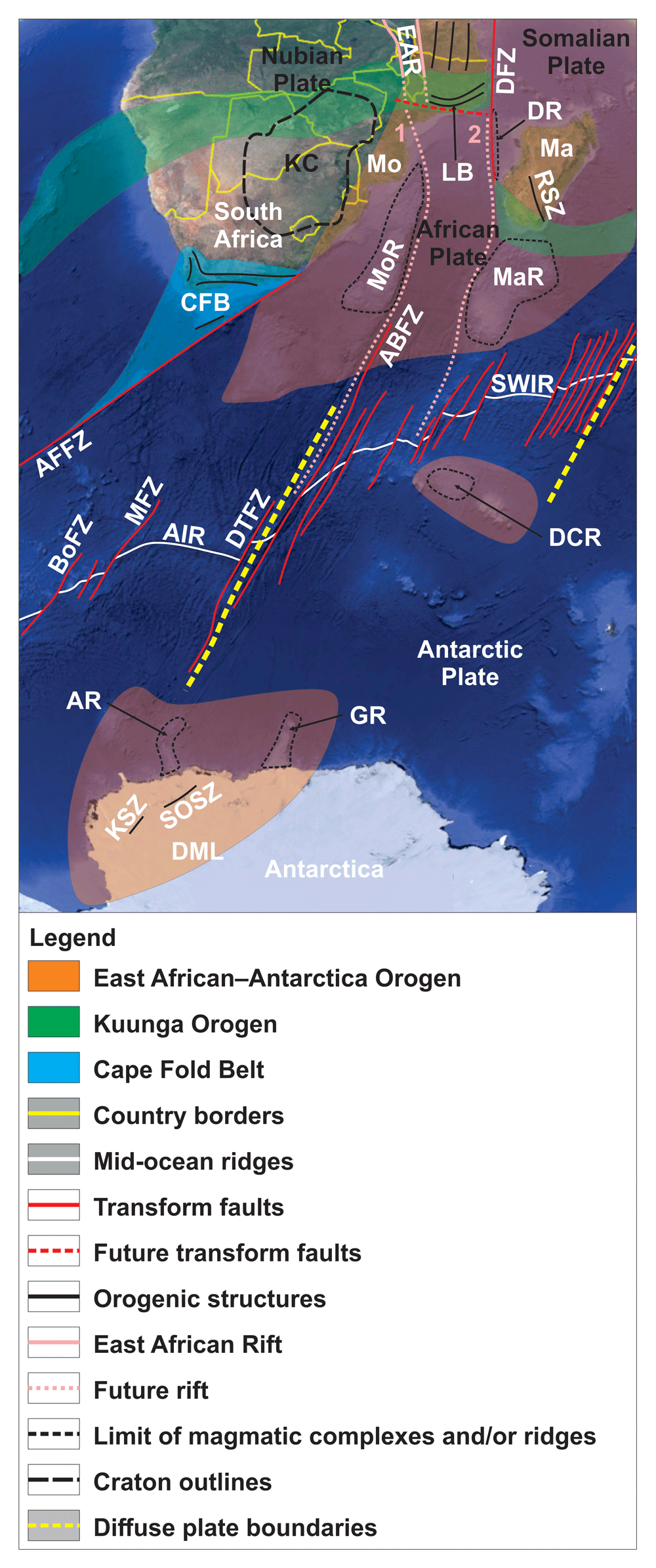
Figure 5. Topographic–bathymetric map showing the ruptured East African–Antarctic orogenic bridge.
The orogenic bridge coincides with the Andrew Bain Fault Zone and other related major transform fault zones crosscutting the Southwest Indian Ridge. The orogenic structures in Antarctica, Africa, and Madagascar are from Jacobs (1999), Johnston (2000), Sacchi et al. (2000), Ruppel et al. (2015), and Armistead (2019). Basemap is from © Google Earth. Abbreviations: ABFZ: Andrew Bain Fault Zone; AFFZ: Agulhas–Falkland fault zone; AIR: Atlantic–Indian Ridge; AR: Astrid Ridge; BoFZ: Bouvet fault zone; DCR: Del Cano Rise; DFZ: Davie fault zone; DML: Dronning Maud Land; DR: Davie Ridge; DTFZ: Du Toit fault zone; GR: Gunnerus Ridge; KC: Kalahari Craton; KSZ: Kirwanveggen Shear Zone; LB: Lurio Belt; Ma: Madagascar; MaR: Madagascar Ridge; MFZ: Moshes fault zone; Mo: Mozambique; MoR: Mozambique Ridge; RSZ: Ranotsara Shear Zone; SOSZ: South Orvin Shear Zone; SWIR: Southwest Indian Ridge.
The Cape–Falkland orogenic bridge
The composition of the crust beneath the Falkland Plateau and Maurice Ewing Bank has long been debated. However, recent studies have provided robust evidence that the crust is continental, albeit relatively thin at Maurice Ewing Bank (e.g., Schimschal & Jokat, 2018). Offshore drilling at Maurice Ewing Bank penetrated continental crust consisting of Mesoproterozoic paragneisses metamorphosed to granulite facies during the late Mesoproterozoic (Chemale Jr. et al., 2018). Moreover, new interpretation of offshore seismic reflection, gravimetric, and magnetic data identified late Paleozoic fold and thrust structures on the Falkland Plateau and at Maurice Ewing Bank (Stanca et al., 2022; Figure 4). From plate paleogeographic reconstructions, folds and thrusts in the Falkland Plateau appear to have been parallel and adjacent to those of the Cape Fold Belt (e.g., Johnston, 2000; Martin et al., 1981; McKay et al., 2018; Mitchell et al., 1986; Newton, 1993; Storey et al., 1999; Veevers et al., 1994; Figure 4). Thus, the late Paleozoic contractional structures on the Falkland Plateau represent the prolongation of the Cape Fold Belt, which rifted away from southeastern South Africa during the opening of the South Atlantic. In the west, onshore southern South America, the Cape Fold Belt correlates with structures of the Sierra de la Ventana fold-and-thrust belt, which shows both comparable structural trends and similar timing of formation (Castillo et al., 2017; du Toit, 1927; Limarino et al., 1999; Lopez-Gamundi, 2006; Rapela et al., 2003; von Gosen et al., 1990; Figure 1 and Figure 4).
The Cape Fold Belt in South Africa and the Falkland Plateau–Maurice Ewing Bank and its continuation onshore South America (Sierra de la Ventana fold-and-thrust belt) parallel major transform faults in adjacent offshore areas. Hence, they strike perpendicular to the active (East Scotia Ridge, American–Antarctic Ridge, and South Atlantic mid-ocean ridge) and paleo-mid-ocean ridges in the area (West Scotia Ridge and Phoenix Ridge; Figure 1 and Figure 4). These include the Agulhas–Falkland fault zone in the South Atlantic (Barker, 1979; Ben-Avraham et al., 1997; Uenzelmann-Neben & Gohl, 2004), and also all major transforms in the southernmost Atlantic Ocean (Conrad, Bullard, and Vinogradov fault zones; Ligi et al., 1999; Mitchell et al., 2000; Sandwell & Smith, 2001) and the Scotia Plate (North Scotia Ridge, South Scotia Ridge, and Shackleton fault zone; Klepeis, 1994; Livermore et al., 2000; Ludwig & Rabinowitz, 1982; Pelayo & Wiens, 1989; Riley et al., 2019; Thomas et al., 2003; Figure 1 and Figure 4). The Falkland Plateau and Maurice Ewing Bank are thus proposed to represent a ruptured, probably partly hyperextended, late Paleozoic orogenic bridge, which forced the opening Mesozoic rift to step along orogen-parallel transform faults.
The southernmost segment of the overall N–S-trending, Cenozoic South America Cordillera in southern Patagonia, the Tierra del Fuego fold-and-thrust belt bends into a WNW–ESE strike (Fuentes, 2023; Klepeis, 1994), i.e., into parallelism with the Sierra de la Ventana fold-and-thrust belt and with the Cape Fold Belt (Figure 4). This contractional belt may therefore also have helped control the formation of major transform faults in the area, though its geometry may have been controlled by the preexisting late Paleozoic fold-and-thrust belts.
The East African–Antarctica orogenic bridge
The late Neoproterozoic East African–Antarctica Orogen is a well-studied branch of the Pan African Orogeny. (e.g., Abdelsalam et al., 1998; Fritz et al., 2013; Shackleton, 1996; Stern & Kröner, 1993). N–S- to NNW–SSE-striking shear zones in Madagascar and eastern Africa potentially extend into the Davie, Mozambique, and Madagascar ridges (Figure 5). These three N–S- to NNW–SSE-striking bathymetric highs are likely cored by continental crust as suggested by new gravimetric and magnetic data and from recent density and plate tectonics modeling (e.g., Klimke et al., 2018; Ryzhova et al., 2022; Sato et al., 2022; Vormann et al., 2020). The Davie and Madagascar ridges are believed to have once been connected to the Gunnerus Ridge (Figure 5) prior to the opening of the southwestern Indian Ocean (Davis et al., 2016; Klimke et al., 2018; Mueller & Jokat, 2019; Vormann & Jokat, 2021).
In Antarctica, the Gunnerus and Astrid ridges represent salients of continental crust off the coast of Dronning Maud Land (Leitchenko et al., 2008; Roeser et al., 1996; Figure 5). Considering the strike of the former, i.e., parallel to major late Neoproterozoic shear zones in Dronning Maud Land, e.g., the South Orvin and Kirwanveggen shear zones (Bauer & Siemes, 2004; Golynski & Jacobs, 2001; Jacobs, 1999; Ruppel et al., 2015; Figure 5), it is probable that structures of the East African–Antarctica Orogen extend offshore into the Gunnerus Ridge.
Such structures may also possibly be preserved at Del Cano Rise, which is also continental (Sato et al., 2022; Figure 5). Further analysis of seismic reflection data at the Gunnerus Ridge and Del Cano Rise should help answer this. Regardless, the sinistral kinematics late Neoproterozoic shear zones in Dronning Maud Land are consistent with that of relative block movements on either side of the Andrew Bain Fault Zone (e.g., Peyve et al., 2007; Sclater et al., 2005), which strike parallel to major late Neoproterozoic faults in Antarctica and the East Africa Orogen (Abdelsalam et al., 1998; Armistead, 2019; Bauer & Siemes, 2004; Boger et al., 2015; Collins et al., 2000; Collins et al., 2012; De Waele et al., 2011; Golynski & Jacobs, 2001; Hamimi et al., 2022; Jacobs, 1999; Johnson, 2014; Key et al., 1989; Mosley, 1993; Quick & Bosch, 1990; Ruppel et al., 2015; Shackleton, 1996; Stern & Kröner, 1993; Figure 5). This also applies to other major transform faults in the region, e.g., the Du Toit, Moshes, and Bouvet fault zones between South Africa and Antarctica (Figure 4 and Figure 5; Ligi et al., 1999), and the Davie fault zone between Madagascar and eastern Africa (Figure 5; Davis et al., 2016). It is therefore probable that the Mozambique, Madagascar and Gunnerus ridges and possibly the Del Cano Rise are part of a disrupted orogenic bridge.
This is further supported by the location of a narrow plate boundary and of a diffuse plate boundary between the Somalia and Nubian plates. This boundary was proposed by Chu and Gordon (1999) to help reconstruct past plate tectonics movements prior to the opening of the Indian Ocean, which is problematic at the Rodrigues Triple Junction (Minster & Jordan, 1978; Royer & Gordon, 1997). The narrow plate boundary coincides with major offsets of the Southwest Indian Ridge by the Andrew Bain Fault Zone and nearby transform faults, whereas the diffuse plate boundary matches the extent of the East African–Antarctica Orogen on either side of the Southwest Indian Ridge (Chu & Gordon, 1999; Meyzen & Schwarz-Schampera, 2023; Figure 1 and Figure 5).
Large-offset, slow-spreading transform such as the Andrew Bain, Vema (southern Caribbean orogenic bridge), and Romanche fault zones (Sergipano–Central African orogenic bridge; Figure 1), display multiple transform segments and oscillatory spreading. Thus, slivers of lithosphere switch from one plate to the other as the plate boundary jumps from one transform fault segment to another (e.g., Bonatti & Crane, 1982). The OrBiT suggests that elongate lithosphere slivers within these transform fault systems are likely continental. This would facilitate the switch of the plate boundary to another fault segment and the switch of movement direction of the lithosphere sliver because it would already be decoupled from the surrounding oceanic lithosphere. The presence of (hyper-) extended continental lithosphere could also explain the different thermal structure of large-offset, multi-segment transform fault systems. These fault systems involve cold crust and they are similar to continental strike-slip faults (Ligi et al., 2002) because they initially developed in continental crust. This is agrees with the presence of older rocks than predicted by typical seafloor spreading within these transform fault system (Bonatti & Crane, 1982; Bonatti et al., 1996).
Passive margins
At passive margins, linear magnetic anomalies near the typically interpreted continent–ocean boundaries do not necessarily reflect the presence of oceanic crust but of (dominantly mafic) igneous intrusions in continental to hybrid crust. In many cases, the continent–ocean boundary is likely to be located farther oceanward (e.g., Geoffroy et al., 2022b; Koopmann et al., 2014). Data from exploration wells that penetrate continental crust offshore are rarely included in current plate tectonics reconstructions. As a result, the extent of oceanic crust has likely been overestimated by 20–100% along many passive margins around the globe (Geoffroy et al., 2022a), e.g., off the coast of Namibia (Geoffroy et al., 2022b), the Newfoundland–Iberian margin (Lymer et al., 2019; Shillington et al., 2006), and the Rockall Plateau north of Ireland (Dickin, 1992; Roberts et al., 1973).
Namibia–Brazil margin
Off the coast of Namibia, seismic reflection, magnetic, and gravimetric data show that the true continent–ocean boundary lies 100 to 300 km farther oceanward (Geoffroy et al., 2022b). The mafic igneous rocks that comprise seaward-dipping reflectors produce linear magnetic anomalies that may be similar to mid-ocean-ridge-related anomalies (Geoffroy et al., 2022a; Geoffroy et al., 2022b; Koopmann et al., 2014; Reeve et al., 2021). Linear magnetic anomalies occur in highly thinned slivers of continental crust intruded by seaward-dipping reflectors along the Namibian passive margin (Geoffroy et al., 2022b). Not only can linear magnetic anomalies not be relied upon to discriminate oceanic and continental crust, it is now necessary to reevaluate the extent of continental versus oceanic crust at volcanic passive margin.
The crust below the Walvis Ridge shows continental affinities with a thickness and seismic velocities comparable to the crust below Iceland (Fromm et al., 2017a; Fromm et al., 2017b). Basalts locally show traces of crustal contamination (e.g., Eroshenko & Kharin, 2019). On the conjugate South American margin, Proterozoic granite, gneiss, granulite, and gabbro were recovered from dredges on the Rio Grande Ridge (Ventura Santos et al., 2019). These new results indicate that the Walvis–Rio Grande Ridge most likely consists of continental to hybrid crust and that the continent–ocean boundary is located 400–500 km farther oceanward on both margins. This suggests that large portions of the offshore areas are underpinned by continental crust.
This is further supported by the deformation of flowlines into map-view rollover structures at the Walvis Ridge, which indicate dextral strike-slip movement at the interface of the Walvis Ridge and oceanic crust to the northwest (Fairhead & Wilson, 2005). These deformation structures suggest relative movement between the Walvis Ridge and South Atlantic oceanic crust, possibly related to a viscosity contrast between continental to hybrid crust within the ridge and oceanic crust in the northwest. A dextral sense of shear is consistent with seafloor spreading in the northwest sliding past an extending continental crust at the Walvis Ridge.
Newfoundland–Iberian margin
Continental breakup at the Newfoundland and Iberian conjugate hyperextended margins is generally ascribed a relatively late age compared to the central and northern segments of the Atlantic rift (e.g., Causer et al., 2022). In line with the findings of Geoffroy et al. (2022a, 2022b), the ages of the earliest anomalies (145 and 120 Ma; Srivastava et al., 2000) contrast with the age inferred from drilling and dating the breakup unconformity (113 Ma; Boillot et al., 1988; Tucholke & Sibuet, 2007). This suggests that the continent–ocean boundary lies farther seaward than previously proposed. Extreme thinning of the continental crust at passive margins due to extreme extension along low-angle detachments is particularly well illustrated along the Iberian margin (e.g., Lymer et al., 2019; Pérez-Gussinyé, 2013). There, potential Variscan folds and thrusts in hyperextended continental basement seem to have controlled the formation of low-angle extensional detachments and show a top-east vergence (Lymer et al., 2019 their figures 5a–d and 7b), i.e., comparable to Variscan structures in the geosyncline onshore northern Iberia (e.g., Franke, 2006; Pastor-Galan et al., 2020; Shaw et al., 2012).
In contrast to the drastically thinned Iberian continental crust, the broad Newfoundland passive margin displays a relatively thick wedge of continental crust. There, Alleghenian thrusts show a top-east vergence that matches that of coeval Variscan structures on the conjugate Iberian margin (Lefort & Haworth, 1984; Lefort et al., 1993). The upper-plate geometry of the Newfoundland margin and lower-plate geometry (e.g., Lister et al., 1986) of the Iberian margin suggest that Variscan thrusts controlled the breakup and the asymmetry of the margin.
Rockall Plateau
Basement rocks in the Rockall Plateau have now been penetrated by multiple exploration wells, many of which show that the crust there was metamorphosed to amphibolite to granulite facies during the Paleoproterozoic Laxfordian–Ketilidian Orogeny (Attfield, 1987; Dickin, 1992). Despite Mesozoic–Cenozoic extension and associated emplacement of thick igneous rock successions (Johnston et al., 2001; Musgrove & Mitchener, 1996; Roberts et al., 1973), which culminated with the opening of the southern North Atlantic Ocean in the Cretaceous, the entire block is believed to be underlain by Paleoproterozoic continental crust (Dickin, 1992). Despite the Paleoproterozoic ages obtained for the crust there, the Rockall Plateau is rarely included in Paleoproterozoic–Paleozoic plate tectonic reconstructions (e.g., Domeier, 2016), thus giving the continental plates and blocks in these reconstructions more space for movement or resulting in large overlaps of adjacent plates (e.g., Johnston et al., 2001).
Implications for RRR triple junctions
On restoration prior to breakup, several triple junctions linking three mid-ocean ridge segments (RRR) appear to originate at the intersection of at least two major orogens that are oblique to one another. Given the control of rift-orthogonal orogens on the formation of major transform faults, a relationship between at least two orogens and mid-ocean-ridge-related triple junctions is unavoidable. Considering that most mid-ocean ridges are crosscut by transform faults at a high-angle and that T-like triple junctions consist of two parallel ridge segments and a third oblique arm, the OrBiT predicts at least two discrete strikes of transform faults at any RRR triple junction. In other words, RRR triple junctions must form at the intersection of at least two preexisting orogens oblique to one another. To illustrate this, we explore the situation at the Bouvet and Rodrigues triple junctions in the southern Atlantic Ocean and the central Indian Ocean respectively (Figure 1, Figure 4, and Figure 5).
Bouvet Triple Junction
In the southern Atlantic Ocean, the Bouvet Triple Junction connects the southern segment of the Atlantic mid-ocean ridge with the American–Antarctic Ridge in the southwest, and with the Atlantic–Indian Ridge in the southeast (Ligi et al., 1999; Figure 1 and Figure 4). The southern part of the Atlantic mid-ocean ridge is crosscut by E–W- to NE–SW-striking transform faults such as the Agulhas–Falkland fault zone (Figure 1 and Figure 4; Barker, 1979; Ben-Avraham et al., 1997; Uenzelmann-Neben & Gohl, 2004). The E–W-striking Agulhas–Falkland fault zone runs parallel to the late Paleozoic Cape Fold Belt in the Falkland Plateau and Maurice Ewing Bank (Johnston, 2000; Martin et al., 1981; Mitchell et al., 1986; Stanca et al., 2022; Storey et al., 1999) and to the Sierra de la Ventana Fold-and-Thrust Belt in Patagonia (Castillo et al., 2017; du Toit, 1927; Limarino et al., 1999; Lopez-Gamundi, 2006; Rapela et al., 2003; von Gosen et al., 1990; Figure 1 and Figure 4). In South Africa, the fault shows a NE–SW strike and runs parallel to the Cape Fold Belt near Cape Town and Port Elizabeth (Figure 4; Johnston, 2000; McKay et al., 2018; Newton, 1993; Veevers et al., 1994).
In the southwest, the American–Antarctic Ridge is offset by a series of transform faults including the Conrad, Bullard, and Vinogradov fault zones (Ligi et al., 1999; Mitchell et al., 2000; Sandwell & Smith, 2001), which also parallel transform faults in the Scotia Plate, e.g., the North Scotia and South Scotia ridges (Klepeis, 1994; Livermore et al., 2000; Ludwig & Rabinowitz, 1982; Pelayo & Wiens, 1989; Riley et al., 2019; Thomas et al., 2003; Figure 4). All these faults also parallel the Cape Fold Belt and Sierra de la Ventana Fold-and-Thrust Belt; Figure 1 and Figure 4).
East of the Bouvet Triple Junction, the Atlantic–Indian Ridge is truncated by NE–SW- to N–S-striking transform faults, which include the Andrew Bain Fault Zone (e.g., Peyve et al., 2007; Sclater et al., 2005) and other minor faults such as the Du Toit, Moshes, and Bouvet fault zones (Figure 4; Ligi et al., 1999). There, the transform faults parallel the East African–Antarctica Orogen and related shear zones, both in Antarctica (Bauer & Siemes, 2004; Golynski & Jacobs, 2001; Jacobs, 1999; Ruppel et al., 2015), eastern Africa (Abdelsalam et al., 1998; Hamimi et al., 2022; Johnson, 2014; Key et al., 1989; Mosley, 1993; Quick & Bosch, 1990; Shackleton, 1996; Stern & Kröner, 1993), and Madagascar (Armistead, 2019; Boger et al., 2015; Collins et al., 2000; Collins et al., 2012; De Waele et al., 2011; Figure 5).
Major transform faults offsetting the southern segment of the Atlantic mid-ocean ridge and the American–Antarctic Ridge strike parallel to one another, and both groups of transform faults parallel the late Paleozoic, E–W-striking Sierra de la Ventana Fold-and-Thrust Belt (Castillo et al., 2017; Lopez-Gamundi, 2006) and its offshore continuation as the Cape Fold Belt (Stanca et al., 2022; Figure 4). However, major transform faults associated with the Atlantic–Indian Ridge (e.g., Andrew Bain Fault Zone) are oblique (c. 45°) to the above-mentioned transforms as they parallel the East African–Antarctica Orogen (Figure 4 and Figure 5; Collins et al., 2000; Collins et al., 2012; Ruppel et al., 2015; Shackleton, 1996). When restored prior to the opening of the three mid-ocean ridge segments, the Bouvet Triple Junction lies at the intersection of the Cape Fold Belt and the East African–Antarctica Orogen near the eastern tip of Maurice Ewing Bank, the eastern tip of the Cape Fold Belt in South Africa, and between the Grunehogna and Kalahari cratons prior to rifting (see black arrow in Figure 1 and Figure 4; e.g., Mueller & Jokat, 2019; Tomasi et al., 2021).
Rodrigues Triple Junction
Similar to the T-like Bouvet Triple Junction in the southern Atlantic Ocean (Figure 4), the Rodrigues Triple Junction connects the NE–SW-striking Southwest Indian Ridge with the NW–SE-striking Southeast Indian and Central Indian ridges in the Central Indian Ocean (Figure 1 and Figure 6; Meyzen & Schwarz-Schampera, 2023; Munschy & Schlich, 1989; Patriat & Segoufin, 1988). The Southeast Indian and Central Indian ridges are crosscut by large NE–SW-striking transform faults such as the Marie Celeste fault zone (Figure 6; Chen et al., 2017; Mahoney et al., 1989; Mukhopadhyay & Iyer, 1993; Nauret et al., 2006). In contrast, the Southwest Indian Ridge is truncated by NE–SW- to N–S-striking transform faults (e.g., Andrew Bain Fault Zone; Figure 4 and Figure 6; Peyve et al., 2007; Sclater et al., 2005) that strike parallel to late Neoproterozoic structures of the East African–Antarctica Orogen (see previous sections and Figure 5).
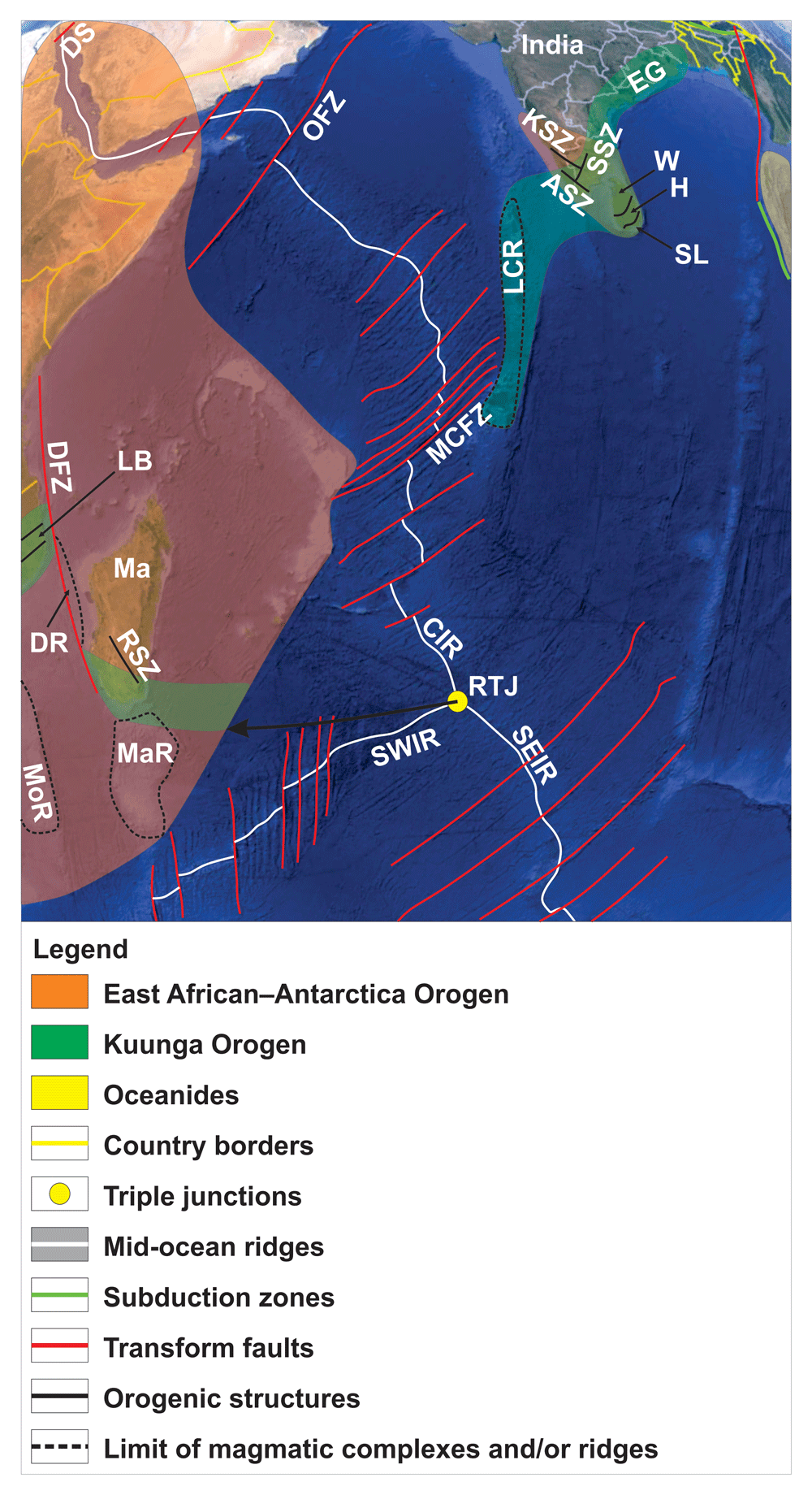
Figure 6. Topographic–bathymetric map showing the relationship of major transform faults in the central and northern Indian Ocean with the East African–Antarctic and Kuunga orogens and related orogenic structures (e.g., Marie Celeste fault zone striking parallel to structures in the Lurio Belt in Mozambique).
When restored prior to the opening of the Indian Ocean, the Rodrigues Triple Junction coincides with the intersection of the Kuunga and East African–Antarctica orogens in southern Madagascar (black arrow). The orogenic structures in India, Madagascar, and Mozambique are from Sacchi et al. (2000), Collins et al. (2003), Brandt et al. (2014), and Armistead (2019). Basemap is from © Google Earth. Abbreviations: ASZ: Achankovil Shear Zone; CIR: Central Indian Ridge; DFZ: Davie fault zone; DR: Davie Ridge; DS: Dead Sea Transform; EG: Eastern Ghats; H: Highland Complex; KSZ: Karur–Kambam–Painavu–Trichur Shear Zone; LB: Lurio Belt; LCR: Laccadive-Chagos Ridge; Ma: Madagascar; MaR: Madagascar Ridge; MCFZ: Marie Celeste fault zone; MoR: Mozambique Ridge; OFZ: Owen fault zone; RSZ: Ranotsara Shear Zone; RTJ: Rodrigues Triple Junction; SEIR: Southeast Indian Ridge; SL: Sri Lanka; SSZ: Suruli Shear Zone; SWIR: Southwest Indian Ridge; W: Wanni Complex.
Transform faults associated with the Southeast and Central Indian ridges show a comparable strike to that of NE–SW-striking folds, thrusts, and shear zones of the late Neoproterozoic–Cambrian Kuunga Orogen, including the Lurio Belt in northeastern Mozambique (Figure 6; Bingen et al., 2009; Collins et al., 2003; Sacchi et al., 2000; Viola et al., 2008) and their counterparts in southern India and Sri Lanka (Figure 6; Axelsson et al., 2020; Brandt et al., 2014; Dharmapriya et al., 2015; Ghosh et al., 2004; He et al., 2018; Hirayama et al., 2020; Srinivasan & Rajeshdurai, 2010). The dominantly sinistral strike-slip, NE–SW-striking shear zones within the Lurio Belt bend E–W westwards, suggesting a possible link with the late Neoproterozoic, WNW–ESE-striking Ranotsara Shear Zone in southern Madagascar, which also displays evidence of sinistral strike-slip kinematics (Figure 5 and Figure 6; Collins et al., 2003; Tucker et al., 2007). The latter was correlated with the Achankovil Shear Zone and/or the Karur–Kambam–Painavu–Trichur Shear Zone in southern India (Figure 6; Collins et al., 2003; Ghosh et al., 2004).
Since the NE–SW-striking, sinistral segment of the Karur–Kambam–Painavu–Trichur Shear Zone appears to continue southwards as the NE–SW-striking Suruli Shear Zone, it is probable that the Karur–Kambam–Painavu–Trichur Shear Zone and the Suruli Shear Zone correlate with NE–SW-striking sinistral shear zones in the Lurio Belt (Brandt et al., 2014; Srinivasan & Rajeshdurai, 2010). Transform faults in the central Indian Ocean, such as the Marie Celeste fault zone, notably parallel the NE–SW-striking segment of the Karur–Kambam–Painavu–Trichur and NE–SW-striking Suruli shear zones in southern India, the NE–SW-striking Eastern Ghats in eastern India, and the NNE–SSW- to NE–SW-striking Highland and Wanni complexes in Sri Lanka (Figure 6; Axelsson et al., 2020; Collins et al., 2003; Dharmapriya et al., 2015; Ghosh et al., 2004; He et al., 2018; Hirayama et al., 2020; Kitano et al., 2017; Meert, 2003).
Reconstruction of the Rodrigues Triple Junction prior to opening of the Indian Ocean shows that it most likely initiated near the southern tip of Madagascar and southern India, the northern tip of the Gunnerus Ridge, and just east of the Lurio Belt in northeastern Mozambique (e.g., Ghosh et al., 2004; Mueller & Jokat, 2019). Thus, the Rodrigues Triple Junction probably formed at the intersection of the N–S-trending East African–Antarctica Orogen in Madagascar (see black arrow in Figure 6; possibly including the Mauritia microcontinent; Torsvik et al., 2013), eastern Africa, and Dronning Maud Land in Antarctica with the NE–SW-striking Kuunga Orogen (e.g., Lurio Belt) in southern Madagascar (and Mauritia), southern India, and Sri Lanka (see black arrow in Figure 1 and Figure 6).
The plume model
Traditionally, offshore areas underlain by anomalously thick crust or shallow bathymetry where the crust thickness is unknown have been assumed to be oceanic crust thickened by extensive magmatism related to a nearby mantle plume. This has been proposed for example for the GIFR in the northeastern Atlantic (Morgan, 1971; White & McKenzie, 1995) and the Madagascar and Mozambique ridges and Del Cano Rise in the Southwestern Indian Ocean (e.g., Jacques et al., 2019; O’Connor et al., 2019; Ryzhova et al., 2022). The crust at the GIFR is 25–40 km thick, and (1) high surface temperature gradients at geothermal fields (50–100°C.km-1) extrapolated linearly (Flovenz & Sæmundsson, 1993; Hermance & Grillot, 1974), (2) shear wave attenuation and deduced high Vp/Vs ratio (Gebrande et al., 1980), and (3) early magnetoteluric data were all interpreted to indicate a layer with 10–20% melt at 10–20 km depth (Eysteinsson & Hermance, 1985; Hermance & Grillot, 1974). This suggested a plume below Iceland.
At the Mozambique Ridge, similar geochemical signatures suggest a genetic link between local basalts and the Karoo–Vestfjella flood basalts, both of which had been interpreted to originate from the same mantle plume (Jacques et al., 2019). At the Madagascar Ridge and the Del Cano Rise, the crust was interpreted to be of oceanic nature based on seismic refraction data, but this interpretation could not explain the anomalously thick crust there (Goslin et al., 1980; Goslin et al., 1981; Goslin & Diament, 1987; Suo et al., 2016).
Although partly supported by geochemical data (e.g., in Iceland and the Mozambique and Madagascar ridges; Jacques et al., 2019; Kerr, 1995), the mantle plume hypothesis does not reconcile all the data available. In Iceland, several severe issues prevent the acceptance of extensive magmatic underplating related to a mantle plume. First, the thickness of the crust varies between 25 and 40 km, which is much thicker than typical 10-km-thick oceanic crust (Darbyshire et al., 1998; Foulger et al., 2003). Second, there is no seismic evidence of anomalously high temperatures or melt in Iceland’s subsurface (Foulger et al., 2003). Third, the distance separating the oldest rocks presumably produced by seafloor spreading is nearly twice (c. 500 km instead of 290 km) what is predicted by the full-plate spreading rate and plate modeling for the North Atlantic Ocean (Foulger, 2006). Fourth, magnetic and gravimetric anomalies related to seafloor spreading do not extend into the GIFR (Foulger et al., 2020a; Gaina et al., 2017). Fifth, reinterpretation of the RRISP shear wave profiles supporting the presence of large amounts of melt at depth and the plume hypothesis (Gebrande et al., 1980) show that the profiles are compatible with solidus temperatures (e.g., Menke et al., 1995), i.e., that a plume and anomalous temperatures below Iceland are not required (Foulger et al., 2003).
South of Africa and Madagascar, the Mozambique Ridge was arbitrarily interpreted to be of volcanic origin (i.e., oceanic crust) based on weak geophysical evidence (magnetic data; König & Jokat, 2010). A continental composition of the crust thus cannot be excluded. This result influenced additional work (e.g., Jacques et al., 2019) and non-volcanic models for the Mozambique Ridge have been neglected. Seismic refraction and bathymetric data alone are insufficient to establish crustal affinity (e.g., Goslin et al., 1980; Goslin et al., 1981) as demonstrated by an early erroneous interpretation of the Falkland Plateau as oceanic crust (e.g., Schimschal & Jokat, 2018). This oceanic interpretation was invalidated by the penetrating of Mesoproterozoic continental crust by offshore drill holes (Chemale Jr. et al., 2018) and by evidence of the continuation of the late Paleozoic Cape Fold Belt into the Falkland Plateau and Maurice Ewing Bank (Stanca et al., 2022; Figure 4). Moreover, the interpretation of gravimetric data leading to the assumption of anomalously thick oceanic crust had been based on the assumption that a mantle plume was present (e.g., Goslin & Diament, 1987; Suo et al., 2016), an example of circular reasoning. It is now clear that both the Mozambique Ridge and the Madagascar Ridge are underlain by 15–30 km-thick continental (to hybrid?) crust (Ryzhova et al., 2022; Sato et al., 2022).
Geophysical evidence unambiguously suggests that mantle plumes are unlikely to have formed the thickened oceanic crust at the GIFR, Mozambique and Madagascar ridges, and Del Cano Rise (Foulger et al., 2003; Foulger et al., 2020a, Foulger et al., 2020b; Geoffroy et al., 2022a; Ryzhova et al., 2022; Sato et al., 2022). A genetic link between igneous rocks at the Mozambique and Madagascar ridges and those of the Karoo–Vestfjella province is not precluded by our model since the magma intruded continental crusts affected by the same orogenic events (e.g., East African–Antarctic Orogen; Figure 5). Nevertheless, certain issues need to be further studied, e.g., the nature and origin of the Walvis and Rio Grande ridges in the South Atlantic, which have been attributed to the migration of the tectonic plates over the Tristan da Cunha hotspot over time (e.g., Hoyer et al., 2022). Both ridges are oblique to the fracture zones and transform faults, which reflect the direction of seafloor spreading and, therefore, the movements of the tectonic plates in the area. Thus, seafloor spreading and hotspot magmatism are difficult to reconcile with the oblique strike of the ridges.
Progress in geophysical imagery tools, the gradual release of private geophysical data, and the increasing amount of offshore drill cores and exploration wells generally indicate that the extent of oceanic crust on Earth is currently overestimated. Conversely, this implies that the extent of continental crust has been significantly underestimated and/or that the occurrence of hybrid crust (i.e., continental crust extensively intruded by mafic magma) should be considered in many previously inferred oceanic crust domains (e.g., Foulger et al., 2020a; Geoffroy et al., 2022a).
Predictions using the OrBiT
Propagation of the Gakkel Ridge towards northern Russia along the Verkhoyansk Orogen
The OrBiT predicts that the Gakkel Ridge in the Arctic Ocean will propagate towards northern Russia along the parallel Verkhoyansk Orogen and then step along the E–W-striking segment of the Verkhoyansk Orogen, where a major transform may form (Figure 7a–b). Existing data suggest that this is already happening. Seismic data between the Russian tip of the Gakkel Ridge and northern Russia show numerous Mw ≥ 5.0 earthquakes suggesting normal focal mechanisms along major fault systems parallel to the Gakkel Ridge in the Laptev Sea and nearby onshore areas (e.g., Cook et al., 1986; Engen et al., 2003; Franke et al., 2001; Imaeva et al., 2018; Imaeva et al., 2019). These indicate extension off axis (Figure 7b). Rifting may thus be proceeding along the same trend as the Gakkel Ridge towards Tiksi in northern Russia, where the Verkhoyansk Orogen and associated structure strike N–S, i.e., parallel to the Gakkel Ridge (Kuzmichev & Danukalova, 2023; Pavlovskaia et al., 2022; Figure 7a).
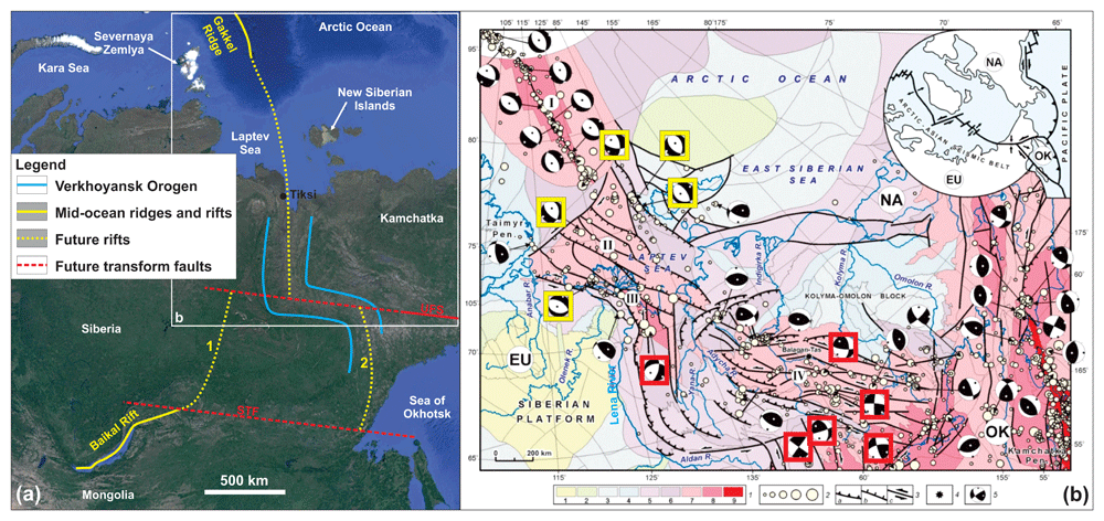
Figure 7.
(a) Location map of the Gakkel Ridge, its termination in the Arctic Ocean, and its possible future propagation (dotted yellow line). The latter could be along the N–S-striking segment of the Verkhoyansk Orogen in northern Russia, stepping sideways along a major future/proto transform fault (e.g., Ulakhan fault system) to form parallel to the E–W-striking segment of the orogen. Southward, the Gakkel Ridge may merge with the Baikal Rift either by stepping to the west along preexisting fabrics of the Vilyui Rift (1) or along the southern continuation of the Verkhoyansk Orogen (2) and via another major step across another transform fault (South Tukuringra fault). Abbreviations: STF: South Tukuringra fault; UFS: Ulakhan fault system. (b) Seismicity related to neotectonic structures in the Laptev Sea and Verkhoyansk Orogen in northern Russia. This shows the dominance of normal movements along the N–S-striking arm of the Verkhoyansk Orogen (yellow squares) and strike-slip kinematics along the E–W-striking segment (red squares) at the location of the predicted future/proto transform fault. 1: Colored areas indicating increasing seismicity; 2: Earthquake epicenters by magnitude (≤ 4.0, 4.1–5.0, 5.1–6.0, 6.1–7.0); 3a: Thrust faults; 3b: Normal faults; 3c: Strike-slip faults; 4: Balagan–Tas volcano; 5: focal mechanisms of earhquakes (lower hemisphere). Modified after Imaeva et al. (2019).
Farther south, the Verkhoyansk Orogen bends c. 90° to an E–W to WNW–ESE strike (Pavlovskaia et al., 2022; Figure 7a). There, the focal mechanisms of Mw ≥ 5.0 earthquakes commonly involve a major component of sinistral strike-slip movement along a WNW–ESE-trending axis (e.g., Cook et al., 1986; Fujita et al., 1997; Imaeva et al., 2018; Imaeva et al., 2019), thus suggesting active, steep, strike-slip faults in the area (Figure 7b). These faults may be related to a major, dominantly sinistral transform plate boundary north of the Sea of Okhotsk possibly related to the Ulakhan fault system (Figure 1; see notably Fujita et al., 1997; Hindle et al., 2006; Hindle et al., 2019; Hindle & Mackey, 2011; Kozhurin et al., 2017; Parfenov et al., 1988).
Although these earthquakes may be related to westwards movements of the Pacific Plate towards the Sea of Okhotsk (e.g., Gorbatov et al., 1994; Gorbatov et al., 1997), should the Gakkel Ridge propagate to the E–W-striking arm of the Verkhoyansk Orogen (Figure 7a), it will meet sub-orthogonal folds and thrust structures crosscut by steeply dipping strike-slip faults in thickened, orogenic continental crust (probably an orogenic bridge). This will hinder the direct linear propagation of rifting (e.g., Molnar et al., 2017). Propagation of the Gakkel Ridge into northern Russia and to the Sea of Okhotsk has already been proposed (e.g., Cook et al., 1986; Fujita et al., 1997). The OrBiT explains the variations in earthquake focal mechanisms in the area – normal in the Laptev Sea and N–S-striking segment of the Verkhoyansk Orogen, and strike-slip at the E–W segment of the orogen (Cook et al., 1986; Imaeva et al., 2018; Imaeva et al., 2019; Figure 7b). This suggests that the Gakkel Ridge will step along a major sinistral transform fault (Ulakhan fault system?) in the Verkhoyansk Orogen (Figure 7a) rather than propagate linearly through northern Russia as suggested by earlier works (e.g., Cook et al., 1986; Imaeva et al., 2019; Parfenov et al., 1988).
From the E–W-striking segment of the Verkhoyansk Orogen and the potential parallel future/proto transform related to the Ulakhan fault system, the Gakkel Ridge may step to the west and merge with the NE–SW-striking segment of the Baikal Rift (which is opening parallel to the late Neoproterozoic and Late Devonian–Mississippian Baikal–Patom Fold-and-Thrust Belt; e.g., de Boisgrollier et al., 2009). This may reactivate preexisting Devonian–Mississippian, NE–SW-striking rift-related structures of the Vilyui Rift in central Siberia (e.g., Kiselev et al., 2012; Polyansky et al., 2017; Ricci et al., 2013; see alternative “1” in Figure 7a). However, there is no indication in the present-day datasets that this is occurring, and the Baikal Rift bends ENE–WSW to the northeast (e.g., Huang & Zhao, 2022; Klyuchevskii et al., 2022; Radziminovich et al., 2013; Figure 7a). Another possibility is that the Gakkel Ridge will step to the east towards the Kuril–Kamchatka volcanic arc possibly in a future backarc setting (alternative “2” in Figure 7a), where the Pacific Plate is subducted below the Sea of Okhotsk (Fujita et al., 1997; Gorbatov et al., 1994; Gorbatov et al., 1997; Parfenov et al., 1988; Rhea et al., 2010). Farther south, the ridge may continue along the southern N–S-striking segment of the Verkhoyansk Orogen (i.e., south of the E–W-striking segment; Figure 7a), and step back to the west and merge with the ENE–WSW-striking arm of the Baikal Rift across another major E–W-striking transform fault, e.g., the sinistral South Tukuringra fault in the Aldan Stanovoy Block (e.g., Imaeva et al., 2017; Ovsyuchenko et al., 2010; Parfenov et al., 1988; Figure 7a).
Southwards propagation of the East African Rift along the East African Orogen
The East African Rift is likely to propagate farther south along existing Ediacaran–Cambrian structures of the East African Orogen (Figure 5). In northeastern Mozambique, it may either (1) propagate south into the N–S-striking Mozambique Ridge (alternative “1” in Figure 5) or (2) step east or west along suborthogonal structures of the Kuunga Orogen in northeastern Mozambique (alternative “2” in Figure 5). Propagation into the continental crust of the Mozambique Ridge (Ryzhova et al., 2022), which was likely deformed by the late Neoproterozoic East African Orogen like adjacent onshore rocks (e.g., Fritz et al., 2013; Shackleton, 1996; Stern & Kröner, 1993), seems the most likely scenario. This is supported by the coincidence of the narrow plate boundary between the Nubian and Somalia plates (Chu & Gordon, 1999) with the potential propagation of the East African Rift along the Mozambique Ridge and the Andrew Bain Fault Zone (Figure 5).
Initially, the NNW–SSE-striking East African Rift would have to propagate through the thickened continental crust of the late Neoproterozoic, NE–SW-striking Lurio Belt (Kuunga Orogen; Bingen et al., 2009; Sacchi et al., 2000; Viola et al., 2008; Figure 5). This may be problematic if the crust is thick. From there, it is hindered from stepping west since those areas comprise long-lived and dry continental crust of the Kalahari Craton (e.g., Oriolo & Becker, 2018; Figure 5). That crust is therefore difficult to extend and cut across (e.g., Peslier et al., 2010). A possible scenario is that the East African Rift steps east (along a major future transform formed parallel to the Lurio Belt?) and further propagates along potential late Neoproterozoic contractional structures of the East African Orogen in the Davie Ridge, Madagascar, and the Madagascar Ridge (Armistead, 2019; Boger et al., 2015; Collins et al., 2000; Collins et al., 2012; De Waele et al., 2011; Klimke et al., 2018; Sato et al., 2022; Vormann & Jokat, 2021), possibly also reusing younger structures (e.g., Davie fault zone; Davis et al., 2016; alternative “2” in Figure 5).
Regardless of whether it propagates through the Mozambique Ridge or the Davie and Madagascar ridges, the East African Rift would propagate within the diffuse plate boundary between the Somalian and Nubian plates inferred to comprise a prolongation of the East African–Antarctica Orogen across the Southwest Indian Ridge (Chu & Gordon, 1999; Meyzen & Schwarz-Schampera, 2023; yellow dashed lines in Figure 5). The OrBiT may therefore help predict the location of future plate boundaries (e.g., future rifts and mid-ocean ridges) and explain the existence of diffuse plate boundaries as transitional plate boundaries, i.e., existing prior to full separation of two or more plates.
However, according to the OrBiT, the new plate boundary and the triple junction at the Southwest Indian Ridge would probably not consist exclusively of mid-ocean ridges, since RRR triple junctions likely form at the intersection of two orogens. In the southwestern Indian Ocean, only one orogen is known in the area where the East African Rift is believed to propagate towards the Southwest Indian Ridge, the East African Orogen (Figure 5). Thus, it is probable that part of the new plate boundary would comprise a transform fault segment, e.g., the Andrew Bain Fault Zone (Figure 5).
Testing the existence of tentative (paleo) transform faults
The OrBiT can help test the plausibility or likelihood of tentative (paleo) transform faults. It predicts that the formation of major transform faults is controlled by orogens (sub-) orthogonal to propagating rifts. Any transform or paleo-transform fault that does not fulfill this condition may thus be discarded as a transform fault or even simply as a fault. Two such examples are the Hornsund Fault Complex segment of the De Geer Zone in western Svalbard and the Wegener Fault between Greenland and Ellesmere Island (Figure 3).
The De Geer Zone
The De Geer Zone is a 1000-km-long, early Cenozoic paleo-transform fault that was assumed to run along the western Svalbard–Barents Sea margin and its postulated conjugate margin in northern Greenland (du Toit, 1937; Faleide et al., 1993; Faleide et al., 2008; ; Harland, 1961; Harland, 1967; Harland, 1969; Horsfield & Maton, 1970; Piepjohn et al., 2016; Wegmann, 1948; Figure 3). The existence of such a physiographic lineament was first proposed based on the linear geometry of both margins (De Geer, 1926). It was subsequently adopted with little criticism as a major paleo-transform fault and became broadly accepted as a fact (e.g., du Toit, 1937; Harland, 1961; Harland, 1967; Harland, 1969; Horsfield & Maton, 1970; Wegmann, 1948). Plate tectonic modeling over the last few decades has usually included the De Geer Zone to explain the opening of the northeastern Atlantic and Arctic oceans (e.g., Cianfarra & Salvini, 2015; Faleide et al., 1993; Harland, 1969; Torsvik & Cocks, 2016). During extension, the De Geer Zone was proposed to have accommodated c. 400 km of lateral movement of Svalbard to the south (Breivik et al., 1998; Faleide et al., 1993; Faleide et al., 2008; Håkansson & Pedersen, 2001; Harland, 1969).
Nevertheless, the De Geer Zone hypothesis does not take into account that nearly half of this transform movement was accommodated by the Spitsbergen and Molloy fault zones in the Fram Strait, which are oblique to the De Geer Zone (Figure 3). Both the Molloy and the Spitsbergen fault zones are observed on various datasets (e.g., Crane et al., 1982; Johnson & Eckhoff, 1966; Myhre & Thiede, 1995; Thiede et al., 1990).
Recent interpretations of geophysical data in the Fram Strait, Svalbard, and the Barents Sea suggest that (1) the Timanian thrust systems continue into the Fram Strait and are found on the conjugate northeastern Greenland passive margin (Koehl, 2020; Koehl et al., 2021; Figure 2), (2) Timanian thrust systems west of Svalbard can be traced continuously without any lateral offset across the presumed De Geer Zone (Figure 3; Koehl, 2024 awaiting peer review), and (3) N–S-striking fault segments of the De Geer Zone such as the Hornsund Fault Complex are extensional normal faults rather than strike-slip faults (e.g., Austegard et al., 1988; Eiken, 1994; Gabrielsen et al., 1990; Riis & Vollset, 1988; Schaaf et al., 2020). These observations cast doubt on the presumed 400 km of dextral movements of Svalbard considered to have occurred along the N–S-striking De Geer Zone. An additional problem is the unrealistic slip rate that would be required along the De Geer Zone, which would be as much as three times higher than the San Andreas fault in California. The latter moves in tandem with fast-spreading at the Pacific mid-ocean ridge, whereas the De Geer Zone supposedly moved in response to ultra-slow spreading at the Mohns and Knipovich ridges, which thus cannot justify such anomalously high slip rates (Koehl, 2024 awaiting peer review).
The Wegener Fault
The Wegener Fault was a hypothetical major early Cenozoic sinistral strike-slip fault proposed to exist on the basis of the linear morphology of the Nares Strait and the potential sinistral offset of rock units across the strait (e.g., Taylor, 1910; Figure 3). It was later proposed to have formed as a major transform during the opening of the Labrador Sea and Baffin Bay (e.g., Piepjohn et al., 2016; Saalmann et al., 2005).
The latter is likely almost fully underlain by continental crust (e.g., Welford et al., 2018) and, furthermore, late Neoproterozoic dykes are continuous across the proposed Wegener Fault (e.g., 627 Ma Kap Leiper Dyke) across the Nares Strait with no trace of lateral offset (Dawes, 2008; Hansen et al., 2011; Oakey & Damaske, 2006; Oakey & Stephensen, 2008; Rasmussen & Dawes, 2011). This fault is thus no longer a viable working hypothesis. Nevertheless, some studies continue to use the Wegener Fault hypothesis in tectonic models (e.g., Gilotti et al., 2018; von Gosen et al., 2019).
The OrBiT suggests that since the presumed Wegener Fault does not parallel any known orogens in nearby areas (Figure 3), it is unlikely to exist. Noteworthy, the Wegener Fault does not parallel the other transform faults in the Labrador Sea and Baffin Bay either (e.g., Ungava Fault Zone; Figure 3). The OrBiT can therefore be used to (1) predict the orientation of future transform and paleo-transform faults, and (2) test the plausibility of existing models and transform fault hypotheses.
Implications for plate tectonics and modeling
We propose the existence of long-lived, continuous orogenic bridges, e.g., the late Neoproterozoic Timanian orogenic bridge in the Fram Strait, Paleoproterozoic Nagssugtoqidian–Torngat orogenic bridge, and Paleoproterozoic or late Neoproterozoic GIFR. The theory suggests that past plate tectonics was less dynamic than typically suggested by current plate models. Models involving the repeated opening of Phanerozoic oceans between continental blocks and continents still connected by continuous (or recently ruptured) Precambrian orogenic bridges are no longer viable solutions to geological observations and geophysical datasets, e.g., opening of the Iapetus Ocean and now of the northeastern Atlantic Ocean between Svalbard and Greenland (Kosminska et al., 2014) because they would require the rupture of an orogenic bridge (e.g., Timanian orogenic bridge between Svalbard and northern Greenland) that is still continuous at present (Figure 3). Similarly, models involving large lateral movements of various terranes hundreds to thousands of kilometers in different directions over a few tens of million years (e.g., Harland et al., 1992; Majka et al., 2021) cannot explain local heterogeneities in basement rocks in continuous or recently disrupted orogenic bridges (e.g., Timanian orogenic bridge; Koehl, 2020; Koehl et al., 2022).
The implied overestimation of the extent of oceanic crust on Earth, especially at orogenic bridges (e.g., Foulger et al., 2003; Foulger et al., 2020a; Foulger et al., 2020b; Geoffroy et al., 2022a) and magmatic passive margins (e.g., Geoffroy et al., 2022a; Geoffroy et al., 2022b; Koopmann et al., 2014; Reeve et al., 2021), suggests that the dynamism of seafloor spreading at mid-ocean ridges and the extent of hybrid continental crust should be reexamined. The dynamism and intensity of seafloor spreading at mid-ocean ridges may have been overestimated in many paleogeographic reconstructions.
Further considerations need to be given to preexisting orogens when producing new paleogeographic reconstructions. Many of these commonly include cryptic, unrealistic transform plate boundaries (e.g., Cao et al., 2021; Domeier, 2016; Domeier, 2018; Domeier & Torsvik, 2014; Merdith et al., 2021; Torsvik & Cocks, 2016; Young et al., 2019). These cryptic transform boundaries generally do not fulfill the requirement set by the OrBiT, i.e., formation of major transform faults parallel to preexisting, rift-orthogonal orogens. This suggests that they are unlikely to have formed.










