Introduction
Volcanoes along Mid Ocean Ridges (MORs) are the primary conduits of mantle volatile to the surface of the planet (Bekaert et al., 2021). The plutonic and volcanic complexes left in place into and onto the lithosphere (e.g., intrusive vs. extrusive formations) by magmatic activity also contribute to the fertilization of the upper crust with metals and trace elements important for life (Edmonds et al., 2018; Giovannelli, 2022; Giovannelli, 2023a; Hay Mele et al., 2023). These complexes act to drive local geothermal circulation, sustaining hydrothermally derived springs and secondary geothermal manifestations over timescales of thousands to millions of years. As they slowly cool, the geochemistry and nature of the associated geothermalism change, altering the composition of fluids that influence the diversity of microbial communities in the subsurface.
While active volcanic complexes, such as those found along convergent margins, provide a means to access how subsurface communities respond to volatile degassing at the surface, hotspot volcanism may provide insight into mantle-crust interactions over long timescales. A hotspot is defined as a relatively stable area of the mantle where deep mantle plumes are believed to cause thinning and melting of the overlying lithosphere. Hotspots can be viewed as being stationary over geological timescales in an absolute reference frame, where overriding lithospheric plates ultimately create characteristic hotspot tracks as observed in Hawaii (Jiang et al., 2021) and Yellowstone (Nelson & Grand, 2018).
Because the Iceland hotspot interacts with the North Atlantic Ridge, its track back in time is not characterized by a continuous and age progressed volcanic chain, in contrast to Hawaii for example. Volcanic rocks that characterize the Icelandic hotspot can be found in East and West Greenland and on the west coast of Scotland and Ireland as well as on the North Atlantic Ocean floor (Storey et al., 2007), thus providing clear evidence for the opening of the North Atlantic Ocean (Figure 1).
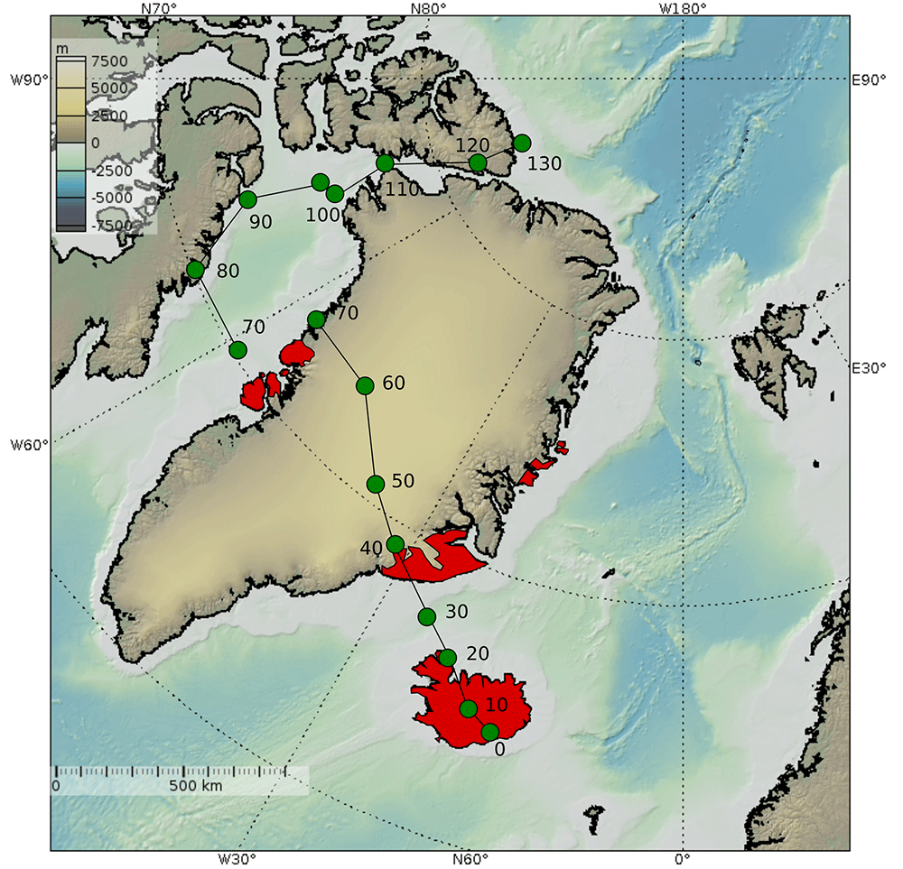
The area in its entirety is known as the North Atlantic Large Igneous Province and has emerged from the Iceland mantle plume activity over the last 70-80 Ma (Saunders et al., 1997). Hotspot-related igneous extrusive rocks are found in East and West Greenland, where they, along with their intrusive counterparts, drive lower temperature thermal springs, comparable to those found on Iceland at present (Hjartarson & Armannsson, 2010). The highest temperature thermal springs in Greenland are found on the east coast, north and south of Scoresbysund, where recorded temperatures reach 62°C. In west Greenland the maximum recorded temperature of a thermal spring is approximately 18°C, on Disko Island (Figure 1).
Disko Island represents a unique location where 70 Ma basalts associated with the Icelandic hotspot are exposed on land and produce low temperature thermal springs. Thousands of springs are present on the island (Figure 2), with a large number of them known by the Innuit as Unatoq. The first mention of the springs in western literature is in 1852 (Rink, 1855). The flora and fauna in these springs were later investigated and found to have a more “southern composition” by Kristensen (Kristensen, 1987).
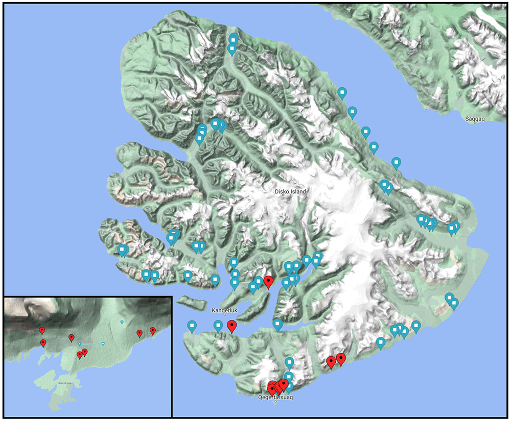
Figure 2. Topographic map of Disko Island with the location of known and putative geothermal manifestations on the island, including cold and warm springs and mud volcanoes on the northern fault system.
The springs appear to be associated with the basaltic fault system present on the island, and emerge often at the contact between the underlying gneiss and overlaying tertiary basalt (see geological description). The insert in the bottom left corner shows a magnification around the Qeqertarsuaq settlement on the south coast of the island where the Arctic Station (University of Copenhagen) is located. Turquoise markers represent putative springs that appear in the literature with no exact coordinates. Red markers represent sampled springs during the GHOST Leg 1 expedition. The map was obtained from Google Maps, Imagery ©2023 TerraMetrics, Map data ©2023.
A series of papers in recent years by Kristensen and others described the tardigrade, rotifera and meiofauna populations found in these springs (reviewed in Funch & Sørensen, 2001; Meyer, 2013). The springs are described as homeothermic, such that their temperature remains constant throughout the year, as opposed to the other surface springs in the area that freeze or dry out during the winter months due to the low temperatures and/or lack of meltwaters (Kristensen, 1987). Six springs in Disko were investigated for their geochemistry and potential geothermal utilization in 2005 (Hjartarson & Armannsson, 2010). No information is available regarding the microbial communities associated with these springs.
The aim of the GHOST project is to provide a glimpse into the microbial diversity associated with these deeply sourced springs. These springs are unique compared with several other geothermally sourced springs found globally, both in terms of their latitude, surrounding environment, as well as the driving rock geochemistry and composition. Additionally, comparing their diversity with the diversity of springs found in Eastern Greenland (sampled in August 2022) and in Iceland (sampled during past expeditions and to be sampled in the framework of the ERC CoEvolve project, https://www.coevolve.eu) provides a unique opportunity to track how the subsurface microbial communities respond to cooling (and differential leaching of metals and volatiles) of the volcanic rocks associate with the Icelandic hotspot. Sampling the hot springs in Disko will simultaneously provide: i) information on the unique diversity present in these springs, ii) information regarding the microbial community interaction with deeply sourced volatiles and biogeochemical cycling in the Arctic, and iii) a unique set of samples providing a transect across the movement of the plate over the Icelandic hot spot.
This report describes the sampling on Disko Island from July 25th to August 2nd, 2022.
Expedition team and logistics
The project team is composed of interdisciplinary scientists spanning the fields of microbiology, biogeochemistry, microbial ecology and gas geochemistry. The expedition was hosted by the Arctic Station (University of Copenhagen) located on the southern coast of Disko Island, West Greenland (69°15’ N, 53°34’ W). Access to the station was provided through the INTERACT III project (EU H2020 Grant Agreement No.871120) Transnational Access call. The Field Science Party was responsible for sample collection and field measurements. Given the remote location of the springs and the lack of roads and paths on the island, access to the springs was limited to a handful of locations within a 4 km radius of the Arctic Station. Two additional springs were sampled in the central part of the island using a small boat to reach the area. The Onshore Science Party was responsible for supporting the logistics and preparation of the expedition as well as collaborating on sample processing and analysis.
Field Science Party composition: Donato Giovannelli (Expedition Leader and PI of the project), Matteo Selci and James A. Bradley.
Onshore Science Party composition: Angelina Cordone, Luciano di Iorio, Monica Correggia, Margaret Cramm, Karen G. Lloyd, J. Maarten de Moor, Peter H. Barry, Shaunna M Morrison, Stefano Caliro, Sæmundur A. Halldórsson.
Geological and environmental settings
The Greenland Ice Sheet is the second largest reservoir of fresh water on Earth and ~80% of Greenland is ice covered. For these reasons, the subglacial thermal conditions, geology, and lithospheric structure of the continental interior are not well known and require indirect methods. Rock outcrops are only accessible near the coast, where direct access provides information regarding their petrology and geochemistry. Greenland is mainly composed of Precambrian provinces that collided during the Early Proterozoic (Braun et al., 2007) (Figure 3). Even though Greenland is considered a stable craton, exposing some of the oldest Archaean rocks on the planet, its lithosphere has been affected by the passage of the Iceland hotspot in the last 90 Mya. Areas of hotspot-related magmatism have been identified based on geochemical signatures both in east Greenland and west Greenland around Disko Island (Figure 3).
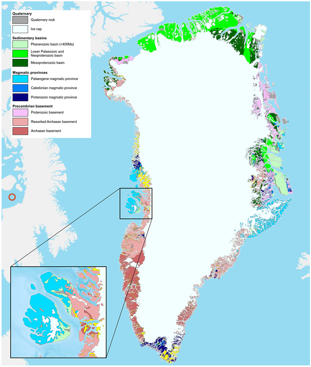
Figure 3. Geological map of Greenland (1:2,500,000) showing the location of the tertiary volcanic basalts (cyan color) on Iceland, East Greenland and West Greenland.
The insert shows the composition of the geology of Disko Island. The geological map was obtained from the Geological Survey of Denmark and Greenland (GEUS) portal (https://maps.greenmin.gl/geusmap).
Disko Island is the second largest island in Greenland after the mainland. The reworked basement of Disko Island is mainly composed of Cretaceous sandstone and Precambrian gneiss, with overlaying tertiary basalt flows visible all over the island dated more than 60 Ma (Figure 4). Geothermal activity is known in several places on Disko Island, with earlier reports dating back to 1852. The source of the geothermal heat and its relation to the stratigraphy and tectonics are unknown, but it seems to be connected to the early Tertiary volcanism associated with the Icelandic hotspot. Known geothermal springs are located along fault systems present on the island (Figure 2), and generally emerge at the contact between the gneiss basement and the overlying basalt (Figure 5).
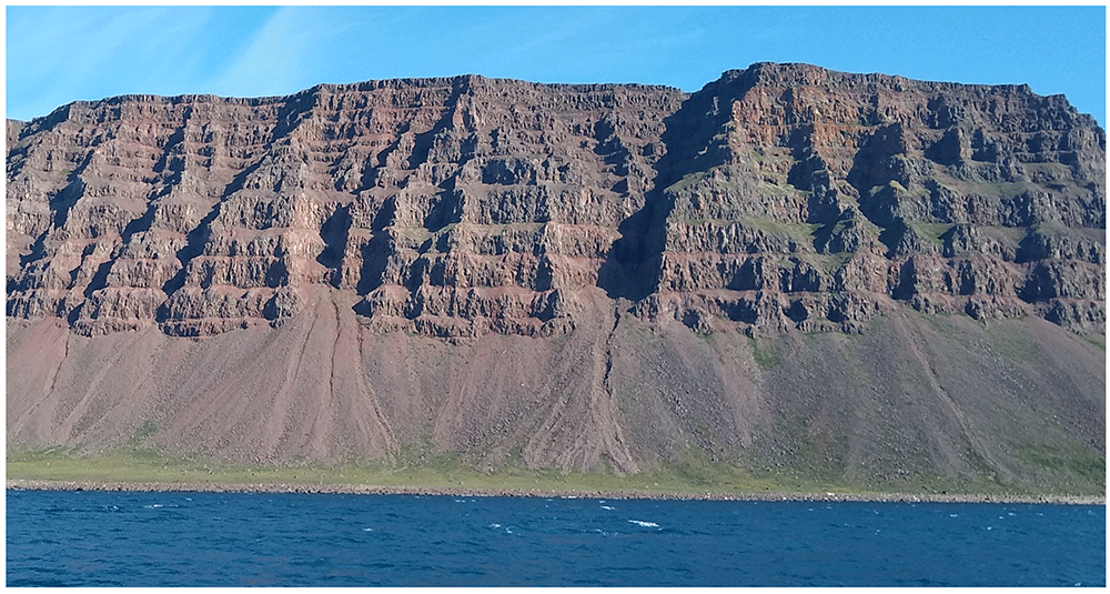
Figure 4. Basalt flow layers overlying the gneiss basement visible on the southern shores of Disko Island.
Photograph taken by author DG for this publication.
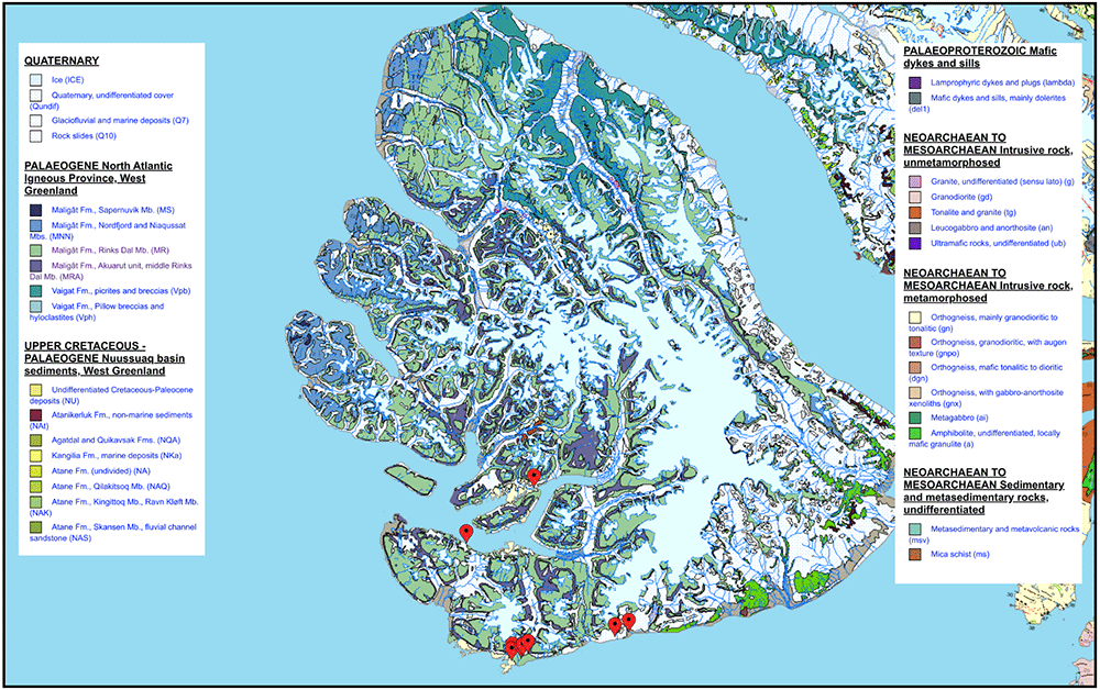
Figure 5. High resolution geological map (1:500,000) of Disko Island.
The sample springs are associated with the contact between Paleocene basalts and the Neoarchaean gneiss. Sampling sites are marked with a red placemark. The geological map was obtained from the Geological Survey of Denmark and Greenland (GEUS) portal (https://maps.greenmin.gl/geusmap).
The springs are characterized by a specific group of plants colonizing their surroundings. The majority of the visited spring showed a strong bright green color in the proximity of the source, mainly linked to the presence of moss and the biennial plant Angelica (Angelica archangelica), an edible wild relative of celery used in Greenlandic cuisine. The presence of this plant in proximity of homeothermic streams provides a useful bioindicator to recognize stable (i.e., not influenced by seasonality) streams on Disko. Kristensen (1987) broadly classified the springs in three groups: 1) cold (0–3 °C) homeothermic springs low in nutrients and characterized by the presence of green moss; 2) warm (3–12 °C) springs low in nutrients and characterized by the presence of Angelica and Arctic willow; and 3) warm (12–18.5 °C) springs rich in nutrients and characterized by “southern” continental species such as orchids and ferns. The latter, he commented, are not recognizable from distance due to the lack of the characteristic bright green color in the surrounding vegetation. Despite the presence of this possible bioindicator, the homeothermic nature of the springs can only be confirmed by measuring their temperature both in the summer and winter, as accomplished in the past by Kristensen (1987). In winter, due to cold air temperatures, springs may be characterized by icings (sheet-like masses of layered ice formed by repeated flows of groundwater to the surface).
Sampling methodologies
Sample selection and environmental parameters
Fluids, sediments and background soils were collected from six locations identified based on the literature (Giovannelli, 2023b). The springs show characteristics compatible with the definition of deeply sourced seeps (Giovannelli et al., 2022). At each sampling site, the main seep outlet was identified using a combination of previous data from literature, field observation, pH, conductivity and temperature measurement. The objective was to sample the pristine gases and fluids as they emerged from the subsurface, minimizing their mixing and interaction with the surface and the atmosphere. Background soil samples from the nearby area that did not show geothermal alterations. The rationale behind this type of sampling approach is to maximize the subsurface information that can be extrapolated from the data. Temperature, conductivity, pH, redox potential, total suspended solids and dissolved oxygen were measured directly in the field using a Hanna Multiparameter WP probe, regularly calibrated. Alkalinity and dissolved hydrogen sulfide were also measured in the field as described below.
Geochemistry samples acquisition
Dissolved gas geochemistry. Fluids for dissolved gas analysis were collected both for gas composition analysis and noble gas isotope systematics. Fluid samples for noble gas analysis were first flushed through silicone tubing and into 3/8-inch copper tubes. After sample flushing (i.e., approximately 10x the volume of the tubing), stainless steel clamps were closed on each end of the copper tubes, trapping the sample inside of the copper tubing, between the clamps (Barry et al., 2022). Fluids for dissolved gas composition were collected in pre-evacuated 250 mL Giggenbach bottles filled to ¾ of the volume taking care to avoid air contamination during collection (Barry et al., 2019).
Aqueous and sediment geochemistry. For the characterization of the major dissolved ions, 0.22 µm filtered fluids were collected in a 50 mL conical tube. A duplicate sample was collected in acid-washed tubes and acidified with nitric acid (2% final concentration) for the analysis of trace elements. Filtered fluids (0.22 µm) were also collected in a 10 mL penicillin vial air-free for dissolved inorganic carbon isotope composition, and 6 mL of fluids were fixed with 2 mL 5% zinc acetate for the quantification of hydrogen sulfide. Sediment samples as close as possible to the fluid outlet point were collected into 50 mL acid-washed conical tubes.
Biological samples acquisition
At each site, sediments and fluid samples were collected aseptically for molecular analysis. Within each pool, the main inlet was identified by using a combination of field observation, pH and temperature analyses (Giovannelli et al., 2022). The objective was to sample the pristine gases and fluids as they emerged from the subsurface. Sediments were collected in close proximity (within centimeters when available) to the inlet. Fluids for DNA extraction (2 L) were filtered in triplicate 0.22 µm Sterivex filter cartridges (MilliporeSigma) (Fullerton et al., 2021). Filtration was achieved using a 3D-printed custom designed peristaltic pump (https://github.com/giovannellilab/Field_3D-printed_peristaltic_pump) connected to a battery powered portable drill. Sediments and background solid were collected in sterile 50 mL conical tubes. Sediments, background and filters were immediately frozen at the Arctic Station. Fluids were also collected in 2 mL cryovial preserved in 3% paraformaldehyde for cell counts. Glass vials (120 mL) were filled with biofilms and fluids for culturing and isolation purposes.
Sites and samples log
Details on the sampling locations are given in Table 1, while the measured environmental parameters are reported in Table 2 (Giovannelli, 2023b). The sampled springs range covers a narrow range of temperatures, with the pH fluctuating between neutral and alkaline conditions (Figure 6). Salinity and total alkalinity (Figure 6 and Figure 7) did not vary systematically with temperature and pH. The description of each sampled location follows together with pictures useful for future identification of the site. A .kmz file containing the exact location of the sampled location is available on the online GitHub repository associated with this report (https://github.com/giovannellilab/GRL22_Leg1_Expedition_report; Giovannelli, 2023b).
Table 1. Sampled springs coordinates and hosting rock type.
| SiteID | CollectionID | Site name | Date | Latitude (°N) | Longitude (°E) | Altitude (m) | Rock type |
|---|
| OR | OR220726 | Orpinguit spring | 2022/07/26 | 69.257247 | -53.518495 | 99.8 | basalt |
| QW | QW220726 | Qeqertarsuaq water | 2022/07/26 | 69.262363 | -53.533825 | 136 | gneiss |
| UH | H220727 | Unartorssuaq High | 2022/07/27 | 69.265183 | -53.5672 | 212 | basalt |
| UK | UK220727 | Unartorssuaq beach | 2022/07/27 | 69.259692 | -53.566644 | 4 | gneiss |
| TQ | TQ220728 | Tarajungistoq | 2022/07/28 | 69.55685 | -53.606526 | 60 | gneiss |
| UN | UN220727 | Unatorq | 2022/07/28 | 69.432154 | -53.890429 | 30 | basalt |
| NJ | NJ220731 | Naujánguit | 2022/07/31 | 69.261233 | -53.462571 | 99 | basalt |
| KU | KU220731 | Kuannit | 2022/07/31 | 69.264886 | -53.443278 | 20.3 | basalt |
| SiteID | CollectionID | Temp
(°C) | pH | ORP
(mV) | DO
(%) | DO
(ppm) | SPC
(mS/cm) | TDS
(ppm) | Sal
(PSU) | Alk
(mg/L) | Flow
(L/s) | Radio
(Bq/L) |
|---|
| OR | OR220726 | 2.1 | 8.31 | -42.3 | 105 | 12.98 | 0.53 | 265.00 | 0.26 | 53.3 | 20 | NA |
| QW | QW220726 | 2.2 | 8.99 | -50.3 | 109 | 13.5 | 0.275 | 140 | 0.14 | 80.0 | 35 | NA |
| UH | H220727 | 3.8 | 9.5 | -44.9 | 93 | 11.2 | 0.434 | 213 | 0.2 | 56.7 | NA | NA |
| UK | UK220727 | 15 | 7.5 | -21 | 43 | 4.39 | 1.315 | 658 | 0.66 | 113.3 | 3.1 | NA |
| TQ | TQ220728 | 12.8 | 8.16 | -16 | 0 | 0 | 3.037 | 1520 | 1.6 | 73.3 | 5 | 705 |
| UN | UN220727 | 12 | 10.4 | -25 | 86 | 8.8 | 0.512 | 255 | 0.25 | 86.7 | 7 | 61 |
| KU | KU220731 | 5.67 | 10.01 | -16 | 87.5 | 10.38 | 0.21 | 105 | 0.1 | 93.3 | NA | NA |
| NJ | NJ220731 | 14 | 8.1 | -10.3 | 95 | 9.8 | 0.114 | 57 | 0.05 | 60.0 | NA | NA |
| QG | QG220801 | 7.9 | 7.27 | -1.6 | 91.6 | 10.22 | 86 | 44 | 0.04 | 60.0 | NA | NA |
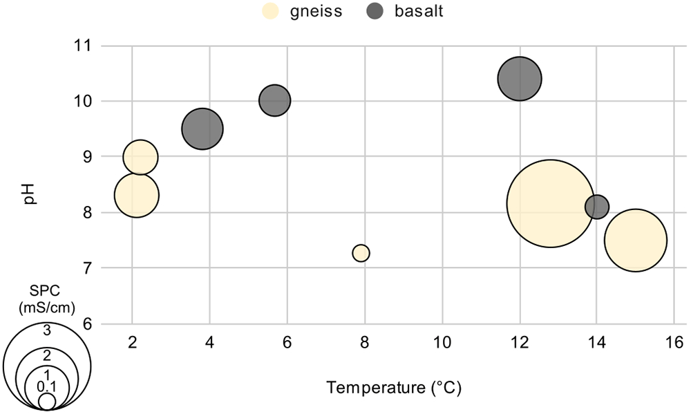
Figure 6. Graph showing the temperature (°C), pH, and conductivity (proportional to the size of the circles in µS/cm) of the sampled locations.
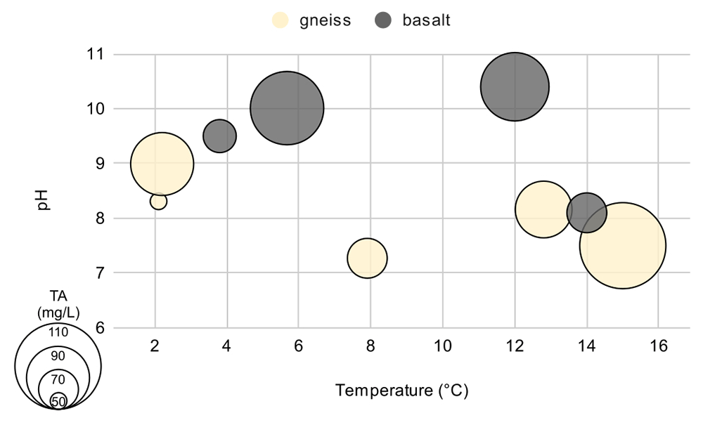
Figure 7. Graph showing the temperature (°C), pH, and total alkalinity (proportional to the size of the circles expressed in mg CaCO3/L) of the sampled locations.
Orpinguit spring (OR)
Orpinguit spring is located approximately 450 m north of the Arctic Station. The cold fluids seep from a fracture in the basalt dome (Figure 8). Fluids were sampled directly from the fracture at about 2.5 meters height. No visible sediments were present at the source, and orange and green biofilms coated the basalt wall influenced by the fluids.
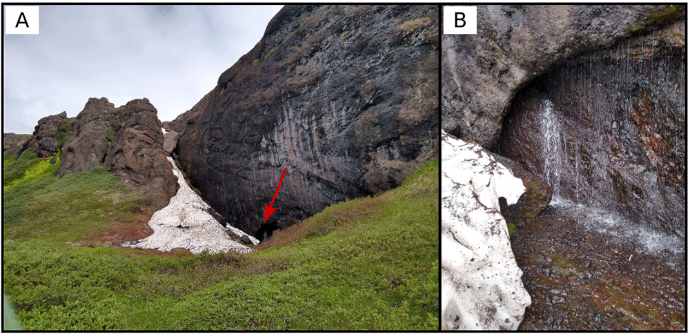
Figure 8. Orpinguit spring, located in a small cove on the side of a volcanic rock outcrop.
A. Large view of the sampling site. B. Detail of the sampling location where the fluids were collected. The red arrow indicates the exact location of the sampling point shown in B. Photograph taken by author DG for this publication.
Qeqertarsuaq water source (QW)
The drinking water supply to the town of Qeqertarsuaq is from one of the homeothermic springs located approximately 1.7 km north of the town. The site has multiple springs seeping from the gneiss outcrops (Figure 9), and the largest are channeled to provide water to the settlement. The characteristic bright green due to the growth of moss is visible in the area of fluid seepage. Samples were collected from the source free from the water supply tubes on the north wall of the area at the point of seepage.
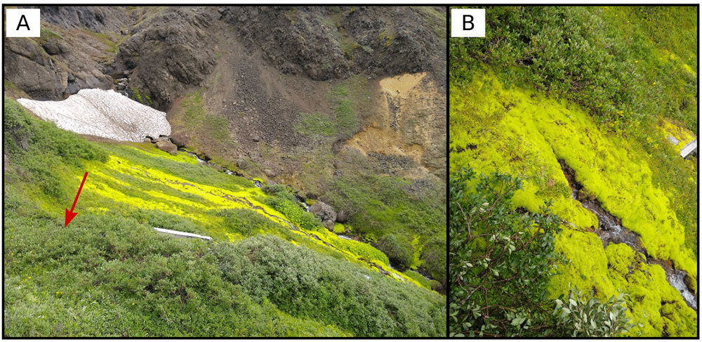
Figure 9. Qeqertarsuaq water source springs, located to the north of the town in the middle of the gneiss outcrops.
Multiple springs were present on site. A. Large view of the sampling site. B. Detail of the sampling location where the fluids were collected. The red arrow indicates the exact location of the sampling point shown in B. Photograph taken by author DG for this publication.
Unartorssuaq high (UH)
A spring in Unartorssuaq, previously described by Hjartarson and Armannsson (2010) was seeping at the contact between the gneiss and the tertiary basalt. The cold spring was seeping from the base of a bush on the slope of the gneiss (Figure 10) and was surrounded by Angelica plants and connected with numerous other springs in the area. The area is characterized by several springs, and the complex terrain makes it difficult to access. A point source was identified for the seep described in Hjartarson and Armannsson (2010).
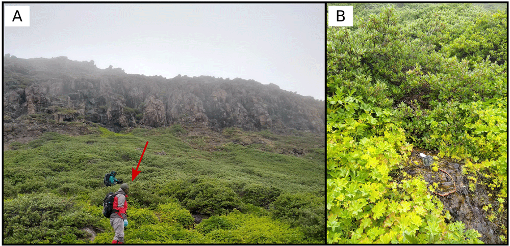
Figure 10. Unartorssuaq high spring, located at the base of the basalt outcrop in contact with the gneiss basement.
Multiple springs were present on site. A. Large view of the sampling site. B. Detail of the sampling location where the fluids were collected. The red arrow indicates the exact location of the sampling point shown in B. Photograph taken by author DG for this publication.
Unartorssuaq beach middle spring (UK)
The Unartorssuaq springs located on the beach of the bay are part of the warm springs sampled previously by Hjartarson and Armannsson (2010), and are the warmest springs sampled during this expedition. The fluids were seeping from the base of erratic gneiss rocks (Figure 11) before disappearing into the gravel of the beach. The waters re-emerge on the gravel before disappearing again. The middle seep was sampled during this expedition. The area, also known as Englishmen Harbor, is difficult to access from the plateau above - requiring hiking down a rockfall and grassy slopes and through a narrow canyon created by the mainstream channel.
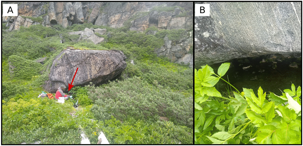
Figure 11. The middle spring, located in Unartorssuaq on the beach.
Multiple springs were present on the beach, and the one that was sampled is located in the middle of the bay. A. Large view of the sampling site. B. Detail of the sampling location where the fluids were collected. The red arrow indicates the exact location of the sampling point shown in B. Photograph taken by author DG for this publication.
Tarajungistoq (TQ)
Tarajungistoq spring is located about 200 meters inland from the north coast of Disko Fjord. From the beach it is possible to follow the outflow channel upstream until a narrow source quickly opening up into a depression can be identified. The fluids precipitate white minerals on the rocks (Figure 12), and thick pink and white microbial biofilms, possibly representing anoxygenic phototrophs and sulfur oxidizers coat the outlet of the spring. The waters are saline, anoxic and radioactive.
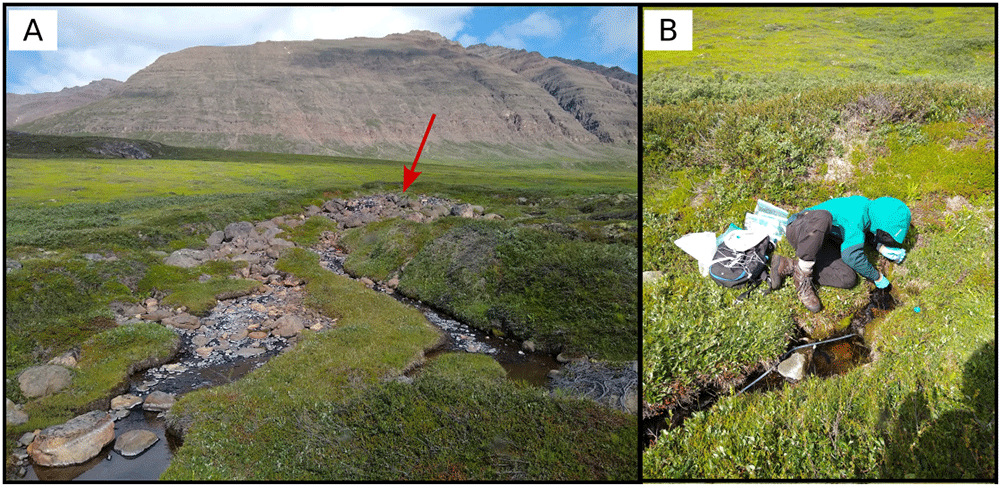
Figure 12. The Tarajungistoq spring, located in the northern coast of Disko fjord, 200 meters from the coast.
A. Large view of the sampling site. B. Detail of the sampling location where the fluids were collected. The red arrow indicates the exact location of the sampling point shown in B. Photograph taken by author DG for this publication.
Unatorq (UN)
The Unatorq spring is located 80 meters inland from the southern coast of Disko Fjord. Multiple small outlets converge into a larger channel (Figure 13). The bottom of the spring is coated with dark green and gray microbial mats, and occasional bubbles are released from the sandy bottom. Unfortunately, the stream of gas was too irregular to allow for sampling. A few locations where fluids were seeping from the spring floor were identified and the more upstream source was sampled. With a pH of 10.4, this is the most alkaline spring sampled.
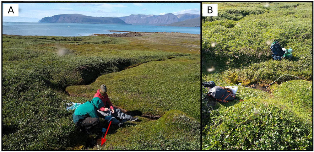
Figure 13. The Unatorq spring, located in the southern coast of Disko fjord, approximately 100 meters from the coast.
A. Large view of the sampling site. B. Detail of the sampling location where the fluids were collected. The red arrow indicates the exact location of the sampling point shown in B. Photograph taken by author DG for this publication.
Kuannit (KU)
The Kuannit area, located on the east of the Arctic Station at about 3.5 km, is characterized by spectacular columnar basalts. Contrary to the previously described locations, exact coordinates for the spring reported originally by Kristensen (1987) are not available, and after measuring basic physico-chemical parameters for a number of sources, a spring seeping directly from fractures in the columnar basalt wall was selected. The spring has a conductivity approximately twice as high as the other surface streams tested during this trip and a pH of 10.01, suggesting water-rock interactions. The fluids were sampled on the right side of the wall in a small crack (Figure 14), directly from the outlet to avoid air contamination. Large quantities of moss and Angelica were present in the area.
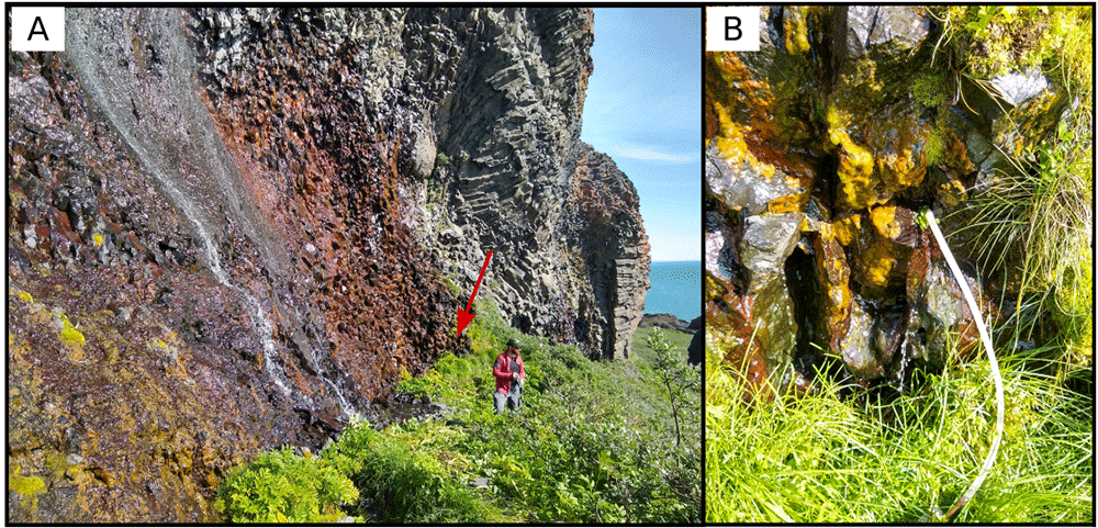
Figure 14. The fluids of Kuannit spring seeping from cracks in the columnar basalt wall.
Fluids were sampled from a small crack on the right side of the outcrop, selected for the easy access to the seep. A. Large view of the sampling site. B. Detail of the sampling location where the fluids were collected. The red arrow indicates the exact location of the sampling point shown in B. Photograph taken by author DG for this publication.
Naujánguit (NJ)
One of the springs in the valley of Naujánguit was sampled on the way back to the station from Kuannit. As for the previous one, no exact coordinates were available for the spring in the area. The spring lacked the characteristic bright green vegetation previously described by Kristensen (1987) (Figure 15) and potentially used as a bioindicator and, based on our initial interpretations, is considered a surface background sample with minimal mixing with deeply derived fluids.
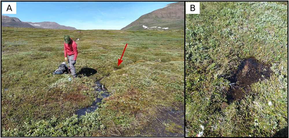
Figure 15. The surface spring is located in the Naujánguit locality in proximity of the yellow trail connecting Qeqertassuaq to Kuannit.
A. Large view of the sampling site. B. Detail of the sampling location where the fluids were collected. The red arrow indicates the exact location of the sampling point shown in B. Photograph taken by author DG for this publication.
Qeqertarsuaq gneiss spring (QG)
The last sampled spring is located in the gneiss formation on the backside of the Arctic Station and seems to be the primary source of the water used at the research station. The location of the spring was extracted from the map by Hjartarson and Armannsson (2010), however no description or previous data are available and therefore the location cannot be confirmed. Personnel at the Arctic Station confirmed that the spring used by the base as source water is a low temperature homeothermic spring available year around. However, the exact source of the fluids could not be identified since it emerged from underneath a large boulder field, and the earliest surface appearance of the fluids between the rocks was sampled (Figure 16). At the source no characteristic vegetation was found, but bright green moss was present downstream.
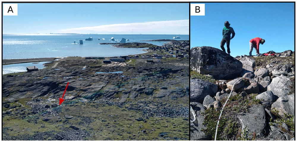
Figure 16. The surface spring is located in a gneiss formation on the backside of the Arctic Station and seems to be the primary source of the water used at the research station.
A. Large view of the sampling site. B. Detail of the sampling location where the fluids were collected. The red arrow indicates the exact location of the sampling point shown in B. Photograph taken by author DG for this publication.
Summary
The expedition successfully sampled a number of springs, including confirmed homeothermic deeply sourced springs described in previous papers (Funch & Sørensen, 2001; Hjartarson & Armannsson, 2010; Kristensen, 1987). This is the first attempt to connect the microbiology of Greenlandic hot springs with the Icelandic hotspot source rocks. A number of other promising springs were too far away for easy access, and will eventually require a dedicated project, possibly in late winter to be able to minimize the influence of meltwaters. All the collected samples were brought back to our home laboratories in Italy, the UK, and the USA for analysis. The data obtained will be made public according to the FAIR Principles for scientific data management.
Ethics and consent
Ethical approval and consent were not required.
Acknowledgements
The authors wish to acknowledge the Arctic Station in Qeqertarsuaq for logistical support in the field and Kasper Broberg for logistic support in sampling some of the springs.
Faculty Opinions recommendedReferences
- Ago S:
Geology of Iceland - Part 2: The Iceland hotspot.
Steemit.
2018; [Accessed July 30, 2022]. Reference Source
- Barry PH, De Moor JM, Chiodi A, et al.:
The Helium and Carbon Isotope Characteristics of the Andean Convergent Margin.
Front Earth Sci.
2022; 10. Publisher Full Text
- Barry PH, Nakagawa M, Giovannelli D, et al.:
Helium, inorganic and organic carbon isotopes of fluids and gases across the Costa Rica convergent margin.
Sci Data.
2019; 6(1): 284. PubMed Abstract
| Publisher Full Text
| Free Full Text
- Bekaert DV, Turner SJ, Broadley MW, et al.:
Subduction-Driven Volatile Recycling: A Global Mass Balance.
Annu Rev Earth Planet Sci.
2021; 49: 37–70. Publisher Full Text
- Braun A, Kim HR, Csatho B, et al.:
Gravity-inferred crustal thickness of Greenland.
Earth Planet Sci Lett.
2007; 262(1–2): 138–158. Publisher Full Text
- Edmonds M, Mather TA, Liu EJ:
A distinct metal fingerprint in arc volcanic emissions.
Nat Geosci.
2018; 11(10): 790–794. Publisher Full Text
- Fullerton KM, Schrenk MO, Yücel M, et al.:
Effect of tectonic processes on biosphere–geosphere feedbacks across a convergent margin.
Nat Geosci.
2021; 14: 301–306. Publisher Full Text
- Funch P, Sørensen MV:
Rotifers in saline waters from Disko Island, West Greenland. In: Rotifera IX. (Springer), 2001; 273–282.
- Giovannelli D:
Geosphere and Biosphere coevolution: the role of trace metals availability in the evolution of biogeochemistry.
EarthArXiv.
X5QH1G, 2022. Publisher Full Text
- Giovannelli D:
Trace metal availability and the evolution of biogeochemistry.
Nat Rev Earth Environ.
2023a; 4: 597–598. Publisher Full Text
- Giovannelli D:
Greenland 2022 GHOST Project: Sampling Greenland Geothermal Springs - Expedition Report Data. Zenodo. [Dataset], 2023b. http://www.doi.org/10.5281/zenodo.10378858
- Giovannelli D, Barry PH, de Moor JM, et al.:
Sampling across large-scale geological gradients to study geosphere-biosphere interactions.
Front Microbiol.
2022; 13: 998133. PubMed Abstract
| Publisher Full Text
| Free Full Text
- Hay Mele B, Monticelli M, Leone S, et al.:
Oxidoreductases and metal cofactors in the functioning of the earth.
Essays Biochem.
2023; 67(4): 653–670. PubMed Abstract
| Publisher Full Text
| Free Full Text
- Hjartarson A, Armannsson H:
Geothermal research in Greenland. In: Proceedings World Geothermal Congress. 2010; 1–8. Reference Source
- Jiang Z, Li S, Liu Q, et al.:
The trials and tribulations of the Hawaii hot spot model.
Earth-Sci Rev.
2021; 215: 103544. Publisher Full Text
- Kristensen RM:
The "southern" flora and the "marine" fauna elements in the homothermic springs on Disko Island, West Greenland.
Ber Über Grönlandsexkursion Inst Für Polarökologie Vom.
1987; 2: 25. Reference Source
- Lawver LA, Müller RD:
Iceland hotspot track.
Geology.
1994; 22(4): 311–314. Publisher Full Text
- Martos YM, Jordan TA, Catalán M, et al.:
Geothermal Heat Flux Reveals the Iceland Hotspot Track Underneath Greenland.
Geophys Res Lett.
2018; 45(16): 8214–8222. Publisher Full Text
- Meyer HA:
Terrestrial and freshwater Tardigrada of the Americas.
Zootaxa.
2013; 3747: 1–71. PubMed Abstract
| Publisher Full Text
- Nelson PL, Grand SP:
Lower-mantle plume beneath the Yellowstone hotspot revealed by core waves.
Nat Geosci.
2018; 11: 280–284. Publisher Full Text
- Rink HJ:
De danske Handelsdistrikter i Nordgrønland: deres geographiske Beskaffenhed og produktive Erhvervskilder. AF Høst, 1855. Reference Source
- Saunders AD, Fitton JG, Kerr AC, et al.:
The north Atlantic igneous province.
Geophys Monogr Ser.
1997; 100: 45–94. Publisher Full Text
- Steinberger B, Bredow E, Lebedev S, et al.:
Widespread volcanism in the Greenland–North Atlantic region explained by the Iceland plume.
Nat Geosci.
2019; 12: 61–68. Publisher Full Text
- Storey M, Duncan RA, Tegner C:
Timing and duration of volcanism in the North Atlantic Igneous Province: Implications for geodynamics and links to the Iceland hotspot.
Chem Geol.
2007; 241(3–4): 264–281. Publisher Full Text