Introduction
Forest regeneration is a critical component of ecosystem recovery, particularly following disturbances such as windstorms, which can have long-term impacts and potentially severe consequences for ecosystem services (Romagnoli et al., 2023). Monitoring and quantifying forest regeneration plays a vital role in sustainable forest management and adaptive planning (Miina et al., 2006; Witzmann et al., 2025). Traditionally, optical remote sensing techniques such as satellite and aerial imagery (Lin et al., 2024), multispectral sensors (Panuju et al., 2020), and vegetation indices like NDVI (Huang et al., 2021) have been widely applied to assess regeneration at broad spatial scales. However, these methods are limited in their ability to detect subcanopy structure, individual saplings, or early-stage regeneration (Johnston et al., 2018; Pontius et al., 2020). Wind disturbance is currently the most significant natural disturbance affecting European forests (Seidl et al., 2014), causing widespread tree damage and influencing microclimatic conditions (Palm-Hellenurm et al., 2024). In mountain forests, such disturbances can result in long-lasting ecological consequences, including altered regeneration trajectories and shifts in forest composition (Romagnoli et al., 2023). One of the most impactful examples is Storm Vaia (October 27–30, 2018), which severely affected Northern Italy, damaging more than 42,500 hectares of forest with wind gusts exceeding 200 km/h (Barbagallo et al., 2024; Chirici et al., 2019). Understanding natural regeneration in such contexts is essential for designing post-disturbance management strategies that foster ecosystem recovery and resilience (Taeroe et al., 2019). In recent years, TLS has become an important tool for detailed structural analysis of forests, producing high-resolution 3D point clouds that allow direct measurements of canopy height, stem density, leaf area index (LAI), and vertical profiles (Liang et al., 2016). TLS enables the detection of saplings, small trees, and even herbaceous layers (Åkerblom & Kaitaniemi, 2021; Vicari et al., 2019; Wilkes et al., 2017). While previous reviews have comprehensively addressed TLS applications in mature forest inventory, biomass estimation, and canopy structure analysis (Calders et al., 2020; Liang et al., 2016), the specific application of TLS for monitoring post-disturbance forest regeneration remains relatively underexplored. Regeneration monitoring presents distinct challenges that differentiate it from mature forest assessment: (i) the need to detect small-stature vegetation including saplings often below 2 m in height, (ii) high spatial heterogeneity characteristic of early successional stages, (iii) the presence of mixed vegetation types including woody regeneration, herbaceous cover, and coarse woody debris, and (iv) rapid temporal changes in structural complexity. These characteristics make regeneration monitoring particularly well-suited to TLS’s fine-scale structural detection capabilities, yet systematic comparison with traditional optical remote sensing approaches in this specific context has been limited. This study addresses this gap by combining a structured literature synthesis with empirical field data to evaluate the comparative advantages of TLS for characterizing post-disturbance regeneration dynamics.
The aim of this study is to evaluate the potential of TLS in characterizing forest regeneration and to identify which structural characteristics can be detected with TLS but not with optical remote sensing methods. This paper combines a systematic literature review with original TLS and remote sensing data collected from a regenerating forest plot affected by Storm Vaia 2018, demonstrating the practical application of TLS for assessing structural features in forest recovery.
This study was guided by the following objectives:
• To conduct a systematic literature review to determine the key structural characteristics of forest regeneration that are more accurately captured by terrestrial laser scanning (TLS) than by optical remote sensing methods.
• To demonstrate the application of TLS through experimental field data to assess parameters such as tree segmentation, height distribution analysis, and leaf area index (LAI) in a regenerating forest plot.
Material and methods
Systematic literature review
A systematic literature review (SLR) was conducted through targeted searches in academic databases, including Scopus, Web of Science, Research Gate, which were selected to cover a broad range of peer-reviewed literature in forestry and remote sensing.
The search strategy combined keywords related to laser scanning, forest regeneration, and optical sensing, including “terrestrial laser scanning”, “TLS”, “LiDAR”, “forest regeneration”, “understory”, “optical remote sensing”, “NDVI”, and “EVI”. Boolean operators (“AND”, “OR”) were used to combine terms, and only articles published between 2020 and 2025 were considered in order to capture recent methodological developments.
The initial search returned 68 records (
Table 1). After removal of duplicates and screening of titles and abstracts, 52 studies were retained for further evaluation. Studies were retained if they (i) focused on forest regeneration or early successional stages, (ii) applied TLS and/or optical remote sensing methods to characterize structural or canopy attributes, and (iii) were published in peer-reviewed journals. Studies were excluded if they addressed unrelated applications (e.g. urban environments, infrastructure) or did not report structural forest metrics relevant to regeneration.
Table 1. Overview of the literature selection and inclusion process.
|
Selection stage | Criteria applied |
Records (n) |
|---|
| Initial search | Database search: Scopus, Web of Science, ResearchGate Years: 2020–2025 | 68 |
| Title/Abstract screening | Document type: Peer-reviewed articles Topic relevance: Forest + TLS + regeneration | 52 |
| Full-text assessment | Inclusion: Field data, forest ecosystems, TLS structural metrics Exclusion: No field validation, non-forest, no quantitative comparison | 34 |
| Final synthesis | Complete assessment of TLS vs optical methods for regeneration | 34 |
Table 2. Comparison of forest regeneration characteristics as measured by TLS and optical remote sensing techniques.
|
Regeneration parameter | TLS |
Optical RS | References |
|---|
| Canopy Structure | Direct measurement | Indirect estimation | Santos et al., 2022; Wardius & Hein (2024) |
| Tree detection- Stem density | High accuracy, including saplings | Limited, often missed in dense canopy | Bogdanovic et al., 2021; Calders et al., 2020; Wardius & Hein, 2024 |
| LAI | Calculated from structural data | Indirect estimation via NDVI or models | Tian et al., 2025; Wang & Fang, 2020; Wei et al., 2020 |
| NDVI -Vegetation Indices | Not applicable | Commonly used for spectral data | Liang et al., 2025; Montero et al., 2023 |
| Vertical structure | Full 3D profile, including multiple layers | Limited to upper canopy | Muumbe et al., 2021; Schraik et al., 2023 |
| Understory-Subcanopy detection | Clearly captured with high detail | Rarely detected below canopy | Adhikari et al., 2023; Puletti et al., 2021 |
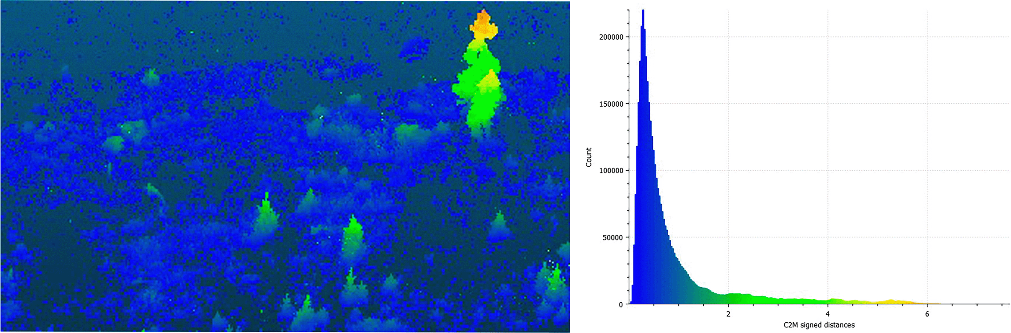
Figure 1. Left: Point cloud colorized by C2M signed distance showing above-ground vegetation structure. Right: Canopy height distribution histogram, showing the frequency of point heights derived from the C2M model.
Following full-text screening, 34 articles met the inclusion criteria and were retained for qualitative synthesis. From these studies, data were systematically extracted on study location, forest type, disturbance context, TLS specifications, derived metrics, and comparative performance with optical methods. Key regeneration-related structural parameters were extracted and compared, including canopy height, stem density, leaf area index (LAI), vertical structure, and understory detection, in order to assess the relative strengths of TLS and optical remote sensing approaches.
Experimental data collection and TLS sampling
Study area
A TLS survey was conducted in May 2025 in a regenerating forest near Nova Levante, Bolzano, Italy (46.42190° N, 11.57144° E), an area impacted by Storm Vaia in 2018. The site lies in a humid continental climate (Dfb, Köppen classification) with an average annual temperature of 5.5°C and annual precipitation of 1,022 mm. Dominant tree species include Norway spruce (Picea abies), European larch (Larix decidua), and Swiss stone pine (Pinus cembra). The study plot was established to assess early forest recovery following windthrow disturbance, with TLS used to measure sapling density, height distribution, and structural complexity.
TLS data acquisition
TLS data were acquired using a RIEGL VZ-600i terrestrial laser scanner (RIEGL Laser Measurement Systems GmbH, Horn, Austria), which operates at a 1550 nm wavelength and utilizes time-of-flight ranging with short infrared laser pulses. The scanner features a beam divergence of 0.3 mrad and offers a full 360° horizontal and 105° vertical field of view, enabling nearly spherical coverage from each scan position. Point cloud acquisition was performed using high-resolution scan settings (6 mm point spacing at 10 m distance) with a pulse repetition rate of up to 2.2 MHz, allowing for rapid data capture across varying terrain and vegetation structures. Multiple scan positions were established across the plot to ensure complete coverage and minimize occlusion effects from dense vegetation and terrain variability.
Point cloud registration and preprocessing
Multiple scan positions were co-registered and georeferenced using RiSCAN PRO software (RIEGL Laser Measurement Systems, Austria). Point clouds from individual scans were cleaned to remove noise, outliers, and non-vegetation objects, then aligned and merged into a unified coordinate system. The registered 3D point cloud was exported to CloudCompare version 2.12.4 (64-bit, GPL software) for subsequent structural analysis.
Ground classification and height normalization
To separate terrain from vegetation, a Cloth Simulation Filter (CSF) was applied within CloudCompare. This algorithm simulates a cloth draped over the inverted point cloud to identify ground points, which were then used to create a Digital Terrain Model (DTM). Off-ground points were retained for canopy analysis. Vegetation height was calculated as the cloud-to-mesh (C2M) signed distance between each vegetation point and the DTM surface. The resulting scalar field was analyzed using CloudCompare’s histogram tool, providing a height distribution of all vegetation in the plot. This distribution was used to assess vertical structure and to establish a 2 m threshold for filtering low vegetation, which typically includes shrubs, herbaceous cover, and ground clutter.
Tree segmentation and individual crown
After filtering out points below 2 m height, the remaining canopy points were segmented into individual tree crowns using connected component labeling in CloudCompare. The “Label Connected Components” tool grouped spatially continuous points into discrete clusters, each representing a potential tree individual. Segmented clusters were visually inspected and colorized by height. One representative tree was selected for detailed vertical profile analysis, and its height distribution was visualized to assess crown structural complexity.
Field observations documented vegetation composition, sapling height, and regeneration density, supported by photographs to aid interpretation of TLS data. NDVI, EVI, and LAI were derived from Sentinel-2 Level-2A surface reflectance imagery using Google Earth Engine. LAI was estimated from NDVI using empirical relationships previously established for temperate coniferous forests (Propastin & Panferov, 2013; Wang et al., 2005). These optical indices provided complementary information on vegetation greenness and canopy density alongside the three-dimensional structural information obtained from TLS.
Results
Results from literature review
Across the literature, TLS proved more effective than optical remote sensing for capturing detailed structural attributes of regenerating forests, especially in early successional stages. Common TLS-derived metrics included canopy height (29 studies), individual tree detection and stem density (25), LAI (18), and vertical structure including subcanopy layers (21). Optical methods more often provided NDVI and related indices (31), broad canopy cover estimates (19), and vegetation health assessments (14). TLS offers direct structural measurements, while optical methods primarily yield indirect estimates from spectral data. Studies consistently report that TLS offers superior performance in detecting early-stage regeneration and subcanopy structure compared to optical methods. Table 2 compares regeneration parameters, showing TLS’s clear advantage in detecting fine-scale details such as saplings and subcanopy structure. The table highlights TLS’s superior performance in capturing fine-scale structural details that are typically missed by optical sensors.
Results from experimental plot
Tree segmentation, height distribution analysis and CHM
The TLS-derived point cloud revealed detailed information on forest structure at both stand and individual tree levels. As shown in
Figure 1, the colorized point cloud illustrates substantial spatial variability in canopy height across the plot, with isolated taller individuals emerging from a predominantly low-stature vegetative matrix. The accompanying histogram confirms a highly skewed height distribution, with the majority of points concentrated below 2 meters typical of early regeneration stages. In contrast,
Figure 2 focuses on a segmented individual tree extracted using connected component analysis. The 3D point cloud reveals a well-defined vertical profile, while its height distribution shows multiple peaks, suggesting structural differentiation within the canopy.
Figure 3 shows CHM generated from TLS data, presented as a rasterized grid. The color gradient represents vegetation height in meters, with blue indicating lower vegetation and red representing taller canopy structures. Black cross markers (+) denote the locations of treetops identified using a local maximum filter applied to the CHM. This spatial representation reveals pronounced heterogeneity in vertical structure across the regenerating plot, with clusters of taller individuals embedded within a predominantly low-stature matrix. The CHM not only supports visualization of canopy development but also enables tree counting and spatial pattern analysis, contributing to a more detailed assessment of regeneration dynamics.
The quantitative contrasts in
Table 3 reflect the structural characteristics observed in the study plot, where regeneration was dominated by saplings between 0.5 and 2.5 m in height. TLS enabled direct detection and segmentation of these individuals, whereas Sentinel-2 based optical indices provided spatially averaged information dominated by the upper vegetation signal. This illustrates why TLS is particularly suitable for characterizing early-stage forest regeneration, while optical remote sensing is better suited for broader-scale monitoring of canopy greenness and temporal trends.
Table 3. Quantitative comparison of terrestrial laser scanning (TLS) and optical remote sensing for forest regeneration assessment in the study plot.
| Parameter | TLS (this study) |
Optical remote sensing
(Sentinel-2) |
|---|
| Spatial resolution | ~6 mm point spacing at 10 m | 10 m pixel size |
| Detectable vegetation height | Saplings ≥0.5 m | Dominant canopy signal only |
| Dominant regeneration height | 0.5–2.5 m saplings clearly resolved | Height not directly resolved |
| Detection of individual saplings | Individual saplings segmented | Individual saplings not detectable |
| Sensitivity to vegetation <2 m | High (majority of points <2 m detected) | Very low |
| Height information | Direct 3D measurement | Indirect proxy |
| LAI estimation | Structure-based
| Spectral index-based
|
| Suitability for early regeneration | High | Limited |
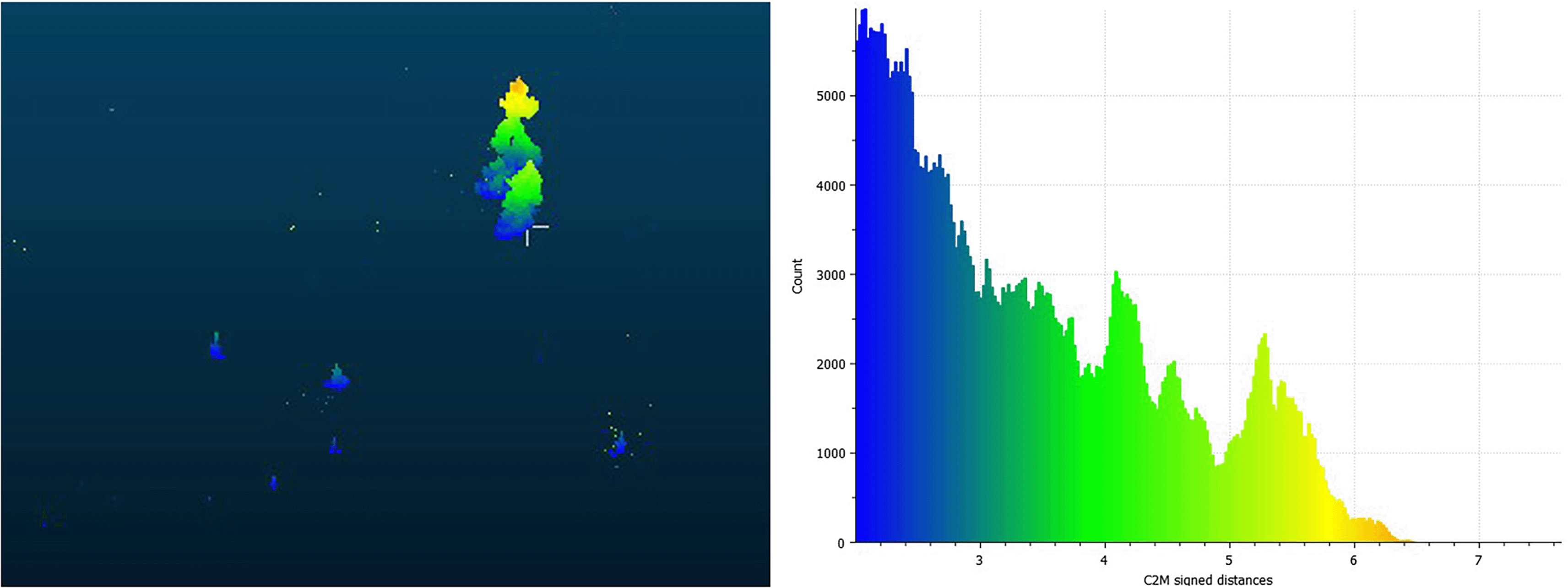
Figure 2. Individual tree extracted from TLS point cloud using connected component segmentation. Left: tree crown point cloud colorized by height (C2M signed distance). Right: vertical distribution of points within the tree, representing the canopy structure and height range.
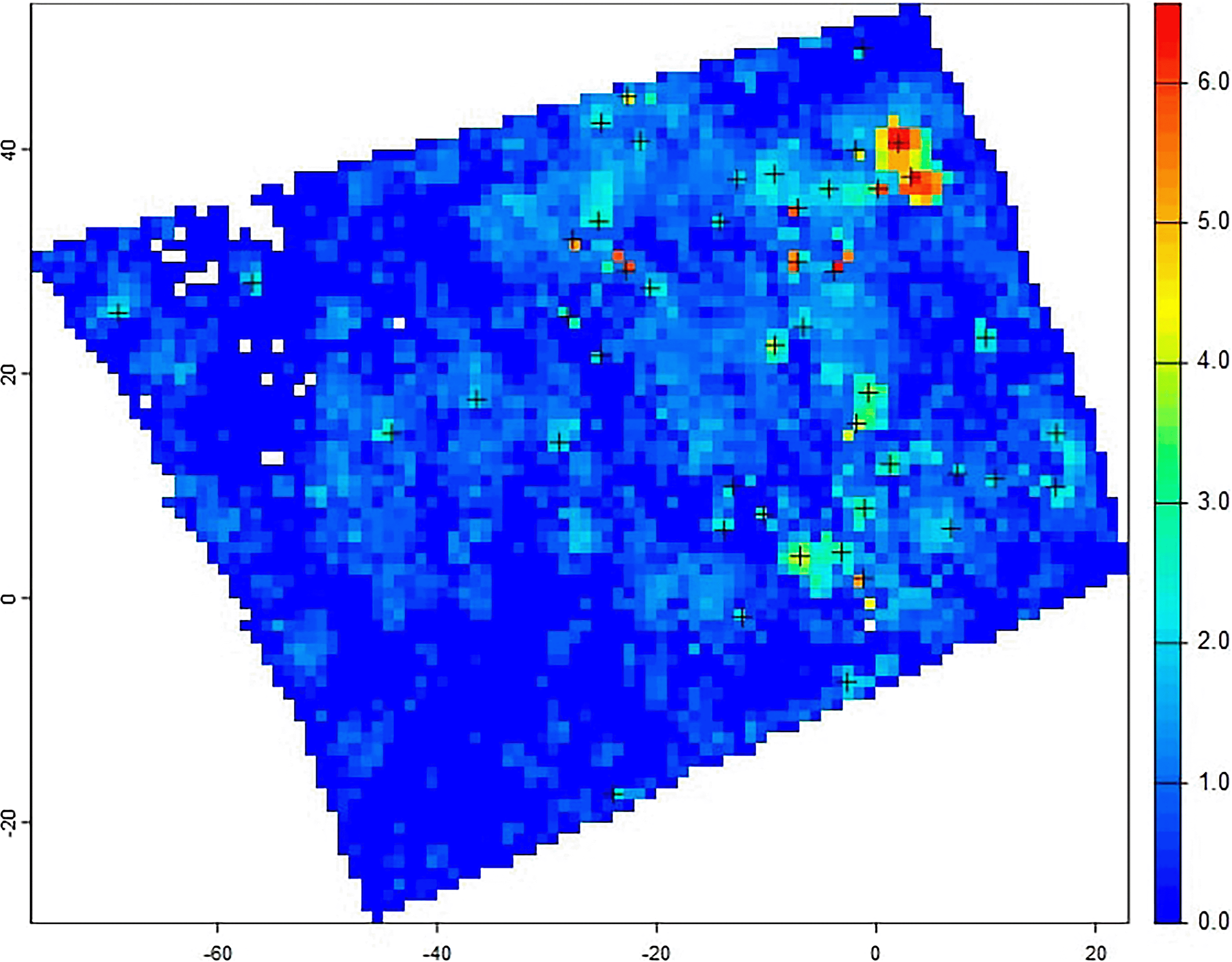
Figure 3. CHM generated from TLS data, showing canopy height (in meters) and detected individual treetops (black crosses) based on local maxima analysis.
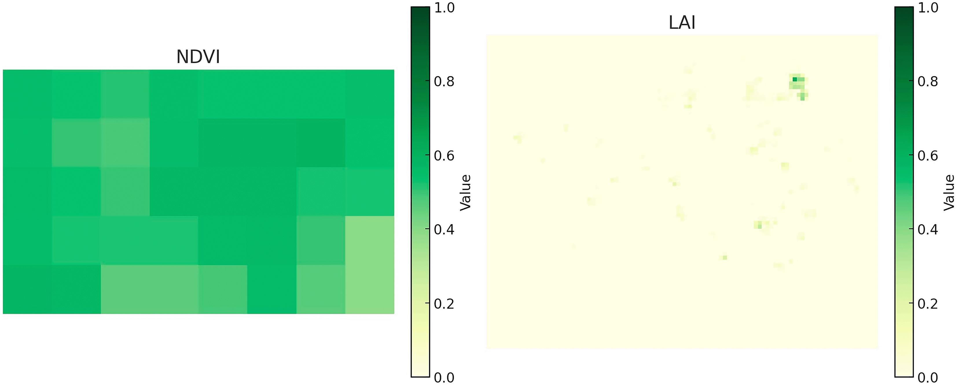
Figure 4. Mapped distribution of NDVI and LAI across the study area in 2025. The left panel shows NDVI (0–1) and the right panel shows LAI (0–6), derived from remote sensing data.
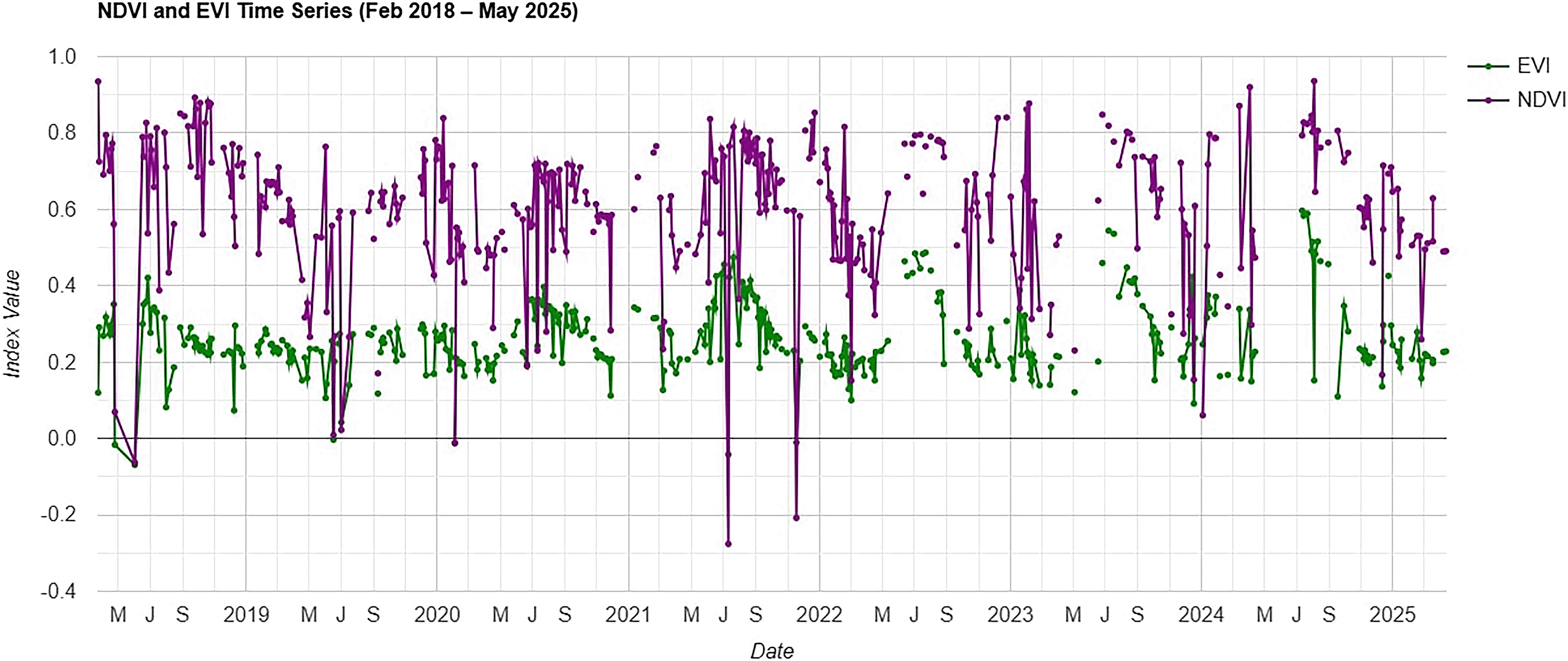
Figure 5. Time series of NDVI and EVI for the study area.
Spatial and temporal patterns in vegetation indices
In 2025, NDVI values (0–1) reflected vegetation greenness, while LAI values (0–6) indicated canopy density (
Figure 4). Both maps showed high spatial heterogeneity, with patches of dense, green canopy interspersed among sparsely vegetated areas typical of early-stage regeneration. Time-series analysis of NDVI and EVI (2018–2025) revealed clear seasonal cycles, with peaks in the growing season and lows in winter (
Figure 5). NDVI was consistently higher, reflecting greater sensitivity to canopy greenness, whereas EVI was more conservative due to reduced atmospheric and soil background effects.
Interannual variation was linked to climate, phenology, and disturbance events, with occasional outliers from residual cloud or atmospheric noise. Together, these indices provided complementary insights into spatial structure and temporal dynamics when integrated with TLS measurements.
Integration of TLS with optical remote sensing
To fully leverage the complementary strengths of TLS and optical remote sensing, we propose several concrete integration strategies for operational forest regeneration monitoring. First, TLS-derived structural metrics (tree height, crown dimensions, stem density, vertical profiles) can serve as high-fidelity reference data for upscaling and validating structural predictions from drone or satellite imagery at broader spatial scales (Calders et al., 2020). For example, plot-level TLS measurements of sapling height and density could be used to train random forest or neural network models that predict these parameters from multispectral drone imagery across entire watersheds. Second, TLS-derived 3D canopy structure can provide direct input to physically-based radiative transfer models (e.g., DART, librat) to improve retrieval of biophysical parameters such as LAI, fraction of absorbed photosynthetically active radiation (fAPAR), and chlorophyll content from satellite spectral data (Gastellu-Etchegorry et al., 2015; Widlowski et al., 2013). Third, a multi-scale hierarchical approach combining plot-level TLS (~102 m2), landscape-level drone LiDAR (~104–106 m2), and regional satellite imagery (~106–109 m2) offers a practical pathway for upscaling fine-scale regeneration processes to management-relevant extents while maintaining structural fidelity (Duncanson et al., 2022). Drone-based LiDAR serves as a critical intermediate scale, bridging the resolution gap between TLS and satellite platforms (Wallace et al., 2016). However, this multi-scale integration presents challenges including differences in sampling geometry, spatial resolution mismatches, and the need for robust upscaling algorithms that account for within-pixel heterogeneity in early-successional forests. Future research should focus on developing standardized protocols for TLS-to-satellite data fusion and quantifying uncertainty propagation across scales (Calders et al., 2020).
Limitations and challenges
Several limitations should be acknowledged. First, our case study was conducted in a single forest type- a mixed conifer forest dominated by Norway spruce, European larch, and Swiss stone pine limiting generalizability to other vegetation communities such as broadleaf forests, mixed temperate forests, or tropical systems. Additionally, the study focused on a single disturbance event (Storm Vaia 2018), and findings may not directly translate to other disturbance regimes such as fire, insect outbreaks, clear-cutting, or drought-induced mortality. Second, the single-epoch TLS survey provides a structural snapshot but cannot capture temporal dynamics of regeneration; based on observed sapling growth rates in similar post-windthrow sites, we recommend repeated TLS surveys at 2–3 year intervals to effectively monitor structural changes while balancing logistical constraints. Third, TLS data collection and processing are resource-intensive, requiring specialized equipment, trained personnel, and approximately 4–6 hours of field time per plot, compared to freely available satellite imagery. Fourth, while TLS excels at capturing fine-scale structure, it lacks the spectral information needed for species identification or physiological assessment without complementary data sources. Fifth, TLS performance may decline in extremely dense regeneration where occlusion limits laser penetration, though this was not a major constraint in our early-successional plot. Finally, our study focused on plot-scale assessment (~400 m2); scaling TLS-derived insights to landscape or regional levels would require integration with airborne LiDAR or satellite-based approaches.
Conclusion
This study highlights the value of TLS as a high-resolution tool for monitoring forest regeneration, particularly in structurally complex or early successional stands. Our literature review and case study show that TLS captures canopy height, stem density, and vertical structure often missed by optical remote sensing. The integration of TLS-derived structural metrics with spectral indices such as NDVI and EVI allowed for a more comprehensive assessment of vegetation condition, capturing both physiological and architectural aspects of forest recovery. Our findings support the growing body of evidence advocating for the use of TLS in forest ecology and suggest that combining structural and spectral data can enhance the accuracy and interpretability of regeneration assessments. TLS should be considered a complementary component in multi-source monitoring strategies aimed at evaluating post-disturbance forest dynamics and informing sustainable forest management.
Ethics and consent
Ethical approval and consent were not required.
Data availability
The datasets used in this study, including NDVI and LAI raster files and TLS point-cloud data, are openly available on Zenodo: 10.5281/zenodo.15762119 (Petrovic et al., 2025). The version used in this article is 10.5281/zenodo.17349048 (Petrovic et al., 2025; Version 3). All files are released under a Creative Commons Attribution 4.0 International (CC BY 4.0) licence and are freely accessible without login or embargo. The Zenodo repository contains all processed outputs of the study, including NDVI and LAI raster files (GeoTIFF format), NDVI and EVI time series data (CSV format), TLS point cloud data (LAS format), representative figures (JPEG), and a README file describing the workflow. For transparency and reproducibility, the Google Earth Engine script used for NDVI/EVI processing is archived in the repository as a standalone JavaScript file. All data and code can be downloaded directly from Zenodo.
Software availability
Al software and scripts used in this study are openly available to ensure transparency and reproducibility.
TLS data processing
RiSCAN PRO (RIEGL, Austria) was used for point cloud registration and georeferencing. CloudCompare v2.12.4 (https://www.cloudcompare.org) was used for ground filtering, height calculations, tree segmentation, and visualization.
Data is available under the terms of the GNU General Public License (GPL).
Authors’ contributions
All authors contributed to the project’s conceptualization, methodology, data collection, and visualization. B. P contributed to TLS data collection, analysis, and manuscript writing. A. C and C. G contributed to data analysis and interpretation. M.S.F supported visualization and manuscript review. E. T supervised the project. All authors approved the final manuscript.
Acknowledgements
The author thanks the Free University of Bozen-Bolzano for hosting her during the Short-Term Scientific Mission, and for providing access to research infrastructure and field equipment.
References
- Adhikari A, Peduzzi A, Montes CR, et al.:Assessment of understory vegetation in a plantation forest of the southeastern United States using Terrestrial Laser Scanning.
Ecol Inform.
2023; 77: 102254. Publisher Full Text
- Åkerblom M, Kaitaniemi P:Terrestrial Laser Scanning: a new standard of forest measuring and modelling?
Ann Bot.
2021; 128(6): 653–662. PubMed Abstract
| Publisher Full Text
| Free Full Text
- Barbagallo B, Rocca N, Cresi L, et al.:Enhanced impacts of extreme weather events on forest: the upper Valtellina (Italy) case study.
Remote Sens.
2024; 16(19): 3692. Publisher Full Text
- Bogdanovic E, Perez-Priego O, El-Madany TS, et al.:Using Terrestrial Laser Scanning for characterizing tree structural parameters and their changes under different management in a Mediterranean open woodland.
For Ecol Manage.
2021; 486: 118945. Publisher Full Text
- Calders K, Adams J, Armston J, et al.:Terrestrial Laser Scanning in forest ecology: expanding the horizon.
Remote Sens Environ.
2020; 251: 112102. Publisher Full Text
- Chirici G, Giannetti F, Travaglini D, et al.:Stima dei danni della tempesta “Vaia” alle foreste in Italia.
Forest@.
2019; 16: 3–9. Publisher Full Text
- CloudCompare (version 2.12.4) [GPL software]. 2022.
- Duncanson L, Kellner JR, Armston J, et al.:Aboveground biomass density models for NASA’s Global Ecosystem Dynamics Investigation (GEDI) lidar mission.
Remote Sens Environ.
2022; 270: 112845. Publisher Full Text
- Gastellu-Etchegorry JP, Yin T, Lauret N, et al.:Discrete anisotropic radiative transfer (DART 5) for modeling airborne and satellite spectroradiometer and LIDAR acquisitions of natural and urban landscapes.
Remote Sens.
2015; 7(2): 1667–1701. Publisher Full Text
- Gorelick N, Hancher M, Dixon M, et al.:Google earth engine: planetary-scale geospatial analysis for everyone.
Remote Sens Environ.
2017; 202: 18–27. Publisher Full Text
- Huang S, Tang L, Hupy JP, et al.:
A commentary review on the use of Normalized Difference Vegetation Index (NDVI) in the era of popular remote sensing.
J For Res.
2021;32(5): 1–6. Publisher Full Text
- Johnston JM, Johnston LM, Wooster MJ, et al.:Satellite detection limitations of sub-canopy smouldering wildfires in the North American boreal forest.
Fire.
2018; 1(2): 28. Publisher Full Text
- Liang D, Cao B, Wang Q, et al.:A new remote sensing index for the detection of multi-type forest anomalies based on sentinel-2 imagery.
Forests.
2025; 16(3): 497. Publisher Full Text
- Liang X, Kankare V, Hyyppä J, et al.:Terrestrial Laser Scanning in forest inventories.
ISPRS J Photogramm Remote Sens.
2016; 115: 63–77. Publisher Full Text
- Lin FC, Shiu YS, Wang PJ, et al.:
A model for forest type identification and forest regeneration monitoring based on deep learning and hyperspectral imagery.
Ecol Inform.
2024;80: 102507. Publisher Full Text
- Miina J, Eerikäinen K, Hasenauer H:
Modeling forest regeneration. In: Hasenauer H (eds)Sustainable forest management.
Springer, Berlin, Heidelberg; 2006. Publisher Full Text
- Montero D, Aybar C, Mahecha MD, et al.:
A standardized catalogue of spectral indices to advance the use of remote sensing in Earth system research.
Sci Data.
2023;10(1): 197. PubMed Abstract
| Publisher Full Text
| Free Full Text
- Muumbe TP, Baade J, Singh J, et al.:Terrestrial Laser Scanning for vegetation analyses with a special focus on Savannas.
Remote Sens.
2021; 13(3): 507. Publisher Full Text
- Palm-Hellenurm K, Tullus T, Vodde F, et al.:Delayed response of bryophytes to wind disturbance and salvage logging in hemiboreal mixed forests.
For Ecol Manage.
2024; 555: 121718. Publisher Full Text
- Panuju DR, Paull DJ, Griffin AL:Change detection techniques based on multispectral images for investigating land cover dynamics.
Remote Sens.
2020; 12(11): 1781. Publisher Full Text
- Petrovic B, Candotti A, Grande C, et al.: NDVI, LAI, and TLS data for forest regeneration study (2025). dataset.
Zenodo. Version 3,2025. Publisher Full Text
- Pontius J, Schaberg P, Hanavan R: Remote sensing for early, detailed, and accurate detection of forest disturbance and decline for protection of biodiversity. In: Cavender-Bares J, Gamon JA, Townsend PA (eds)
Remote Sensing of Plant Biodiversity.
Springer, Cham; 2020. Publisher Full Text
- Propastin P, Panferov O:Retrieval of remotely sensed leaf area index using Landsat ETM+ data and ground measurements of solar radiation and vegetation structure: implication of leaf inclination angle.
Int J Appl Earth Obs Geoinf.
2013; 25: 38–46. Publisher Full Text
- Puletti N, Galluzzi M, Grotti M, et al.:Characterizing subcanopy structure of Mediterranean forests by Terrestrial Laser Scanning data.
Remote Sens Appl.
2021; 24: 100620. Publisher Full Text
- RIEGL Laser Measurement Systems:RiSCAN PRO – RIEGL’s 3D point cloud processing software.2023.Reference Source
- Romagnoli F, Cadei A, Costa M, et al.:Windstorm impacts on European forest-related systems: an interdisciplinary perspective.
For Ecol Manage.
2023; 541: 121048. Publisher Full Text
- Santos EG, Nunes MH, Jackson T, et al.:
Quantifying tropical forest disturbances using canopy structural traits derived from Terrestrial Laser Scanning.
For Ecol Manage.
2022;524: 120546. Publisher Full Text
- Schraik D, Wang D, Hovi A, et al.:Quantifying stand-level clumping of boreal, hemiboreal and temperate European forest stands using Terrestrial Laser Scanning.
Agric For Meteorol.
2023; 339: 109564. Publisher Full Text
- Seidl R, Schelhaas MJ, Rammer W, et al.:
Increasing forest disturbances in Europe and their impact on carbon storage.
Nat Clim Chang.
2014;4(9): 806–810. Publisher Full Text
PubMed Abstract
|
- Taeroe A, de Koning JHCC , Löf M, et al.:Recovery of temperate and boreal forests after windthrow and the impacts of salvage logging: a quantitative review.
For Ecol Manage.
2019; 446: 304–316. Publisher Full Text
- Tian X, Jia X, Da Y, et al.:
Evaluating the sensitivity of vegetation indices to leaf area index variability at individual tree level using multispectral drone acquisitions.
Agric For Meteorol.
2025;364: 110441. Publisher Full Text
- Vicari MB, Calders K, Burt A, et al.:
Leaf and wood classification framework for terrestrial LiDAR point clouds.
Methods Ecol Evol.
2019;10(5): 680–694. Publisher Full Text
- Wallace L, Lucieer A, Malenovský Z, et al.:Assessment of forest structure using two UAV techniques: a comparison of airborne laser scanning and structure from motion (SfM) point clouds.
Forests.
2016; 7(3): 62. Publisher Full Text
- Wang Q, Adiku S, Tenhunen J, et al.:On the relationship of NDVI with leaf area index in a deciduous forest site.
Remote Sens Environ.
2005; 94(2): 244–255. Publisher Full Text
- Wang Y, Fang H:Estimation of LAI with the LiDAR technology: a review.
Remote Sensing.
2020; 12(20): 3457. Publisher Full Text
- Wardius Y, Hein S:Terrestrial Laser Scanning vs. manual methods for assessing complex forest stand structure: a comparative analysis on plenter forests.
Eur J Forest Res.
2024; 143: 635–649. Publisher Full Text
- Wei S, Yin T, Dissegna MA, et al.:An assessment study of three indirect methods for estimating leaf area density and leaf area index of individual trees.
Agric For Meteorol.
2020: 292–293. PubMed Abstract
| Publisher Full Text
- Widlowski JL, Pinty B, Lopatka M, et al.:The fourth radiation transfer model intercomparison (RAMI-IV): proficiency testing of canopy reflectance models with ISO-13528.
J Geophys Res Atmos.
2013; 118(13): 6869–6890. Publisher Full Text
- Wilkes P, Lau A, Disney M, et al.:Data acquisition considerations for Terrestrial Laser Scanning of forest plots.
Remote Sens Environ.
2017; 196: 140–153. Publisher Full Text
- Witzmann S, Gollob C, Kraßnitzer R, et al.:Quantification of forest regeneration on forest inventory sample plots using point clouds from personal laser scanning.
Remote Sens.
2025; 17(2): 269. Publisher Full Text