Introduction
In the last decades, the European geothermal heat pump market has continued to increase, reaching 2.1 million operating units during 20201. Despite the COVID-19 pandemic decreasing the sales of ground source heat pumps (GSHPs) in some countries, around 100,000 were sold in countries with Nordic or Alpine climates such as Sweden, Germany, and Netherlands that cover half of European sales1 where high GSHP penetration rates prevailed. Moreover, Switzerland represents one of the first five countries using shallow geothermal energy where borehole heat exchanger (BHE) systems are the dominant application2 in terms of installed capacity of thermal power per population (MWth/population), land area (MWth/area) and annual energy use for area (TJ/yr/area)2.
Even if in the latest years the total number heat pumps sold is increasing more in the global market, also GSHPs maintain an average of 90 thousand units sold in the period 2014–20183. The use of vertical ground source heat exchangers (GSHEs) increases in urban and built environments. For example, in Stockholm, more than one third of all single-family houses, not connected to district heating, have a ground source heat pump4.
The EU’s energy policy is focused on improving efficiency5 and the use of the renewable energy6. These two factors have to be addressed in the context of the sustainability concept, which insists that the resource must be available even in the long term7.
In urbanized areas, a combination of district heating and stand-alone GSHP systems can result in minimum primary energy requests to supply heat to all the users. Nevertheless, different constraints on GSHP such as thermal interferences between neighbors, should be considered8,9.
The objective of this article is to present recommendations, starting from the state of the art used to find a method and applying this method to the case studies collected and analysed during the GEO4CIVHIC project10. The aim is giving indications to resolve or prevent possible thermal interferences between nearby geothermal systems. These preventative recommendations would help to maximise and guarantee long term efficiency for all geothermal systems. Since the end of the 20th century, studies have confirmed that if geothermal systems are near to each other, there are thermal interferences that can have important effects on the sustainable operation of the system over time, leading to inefficiencies and potential system failure8,11. For these reasons, interference must be considered during the planning phase of any geothermal project. The incorrect management of the resource can generate problems: the thermal and physical interference, malfunction and blocking operation of the systems and ground freezing12,13.
Methods
The most important key factors necessary for the correct planning of installations of GSHPs are presented on the right side of the diagram in Figure 1. These factors were chosen based on the analysis of the data and of the different regulatory procedures required in several countries that was conducted inside the GEO4CIVHIC project and described in a public deliverable14.
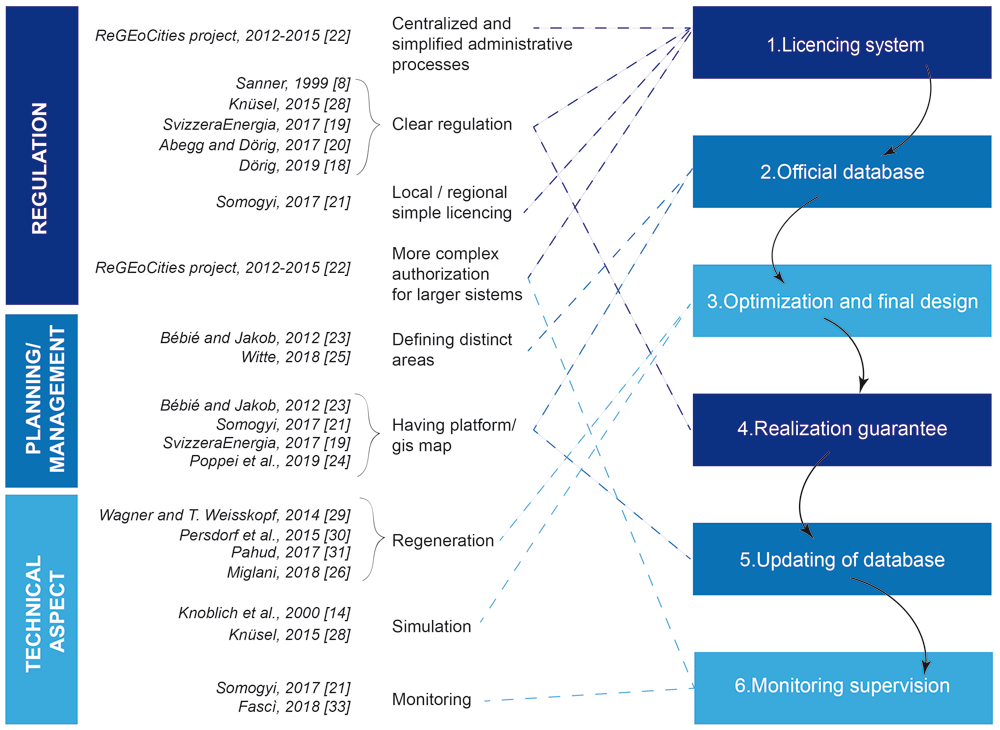
Figure 1. Scheme of the research and main technical references considered related to thermal interference.
Based on previous literature review described in 14, the present research updates and present a literature review of the state of the art related to interferences between geothermal systems with BHE (Figure 1).
The literature review involved in particular:
● national and international technical reports (considering documents in the language English, German, French and Italian);
● the Scopus database using specific keywords in the field of proximity of shallow geothermal systems (e.g.: proximity of borehole heat exchangers system, ground source heat pumps in neighborhood, geothermal interference, geothermal installations in dense urban areas);
● documentation the authors of this article had access to through participation and collaboration with professional associations, working groups, and research programs in the shallow geothermal context.
The approach was not only to include the technical standpoint, that is usually considered in papers and technical studies, but also considering other key factors that are also necessary in the correct installation of a geothermal plant.
A set of basic chronological steps were structured to define all the stakeholders involved in the licencing, planning, design, construction, and operation of geothermal systems. A conceptual model, that simplifies the major phases of the BHE systems installation was elaborated and is presented as a 6-phase circular procedure (P1, P2, etc.) in Figure 2. The licencing system (P1), the presence of an official database where data are collected (P2) and the optimization phase (P3) are the first three steps of the procedure. After the realization of the geothermal system, the correct implementation of the project must be verified (P4). After this verification of the implementation, the updating of the database (P5) is essential to ensure that data recorded corresponds to the information declared as part of the planning, installation and optimisation phases. This is important for the future planning of nearby installations. Monitoring and supervision are the last phase of the procedure (P6). This last step allows verification of the efficiency of the operating system, allowing for the licensing system and the database to be updated, and finally to evaluate the need for any possible adjustments.
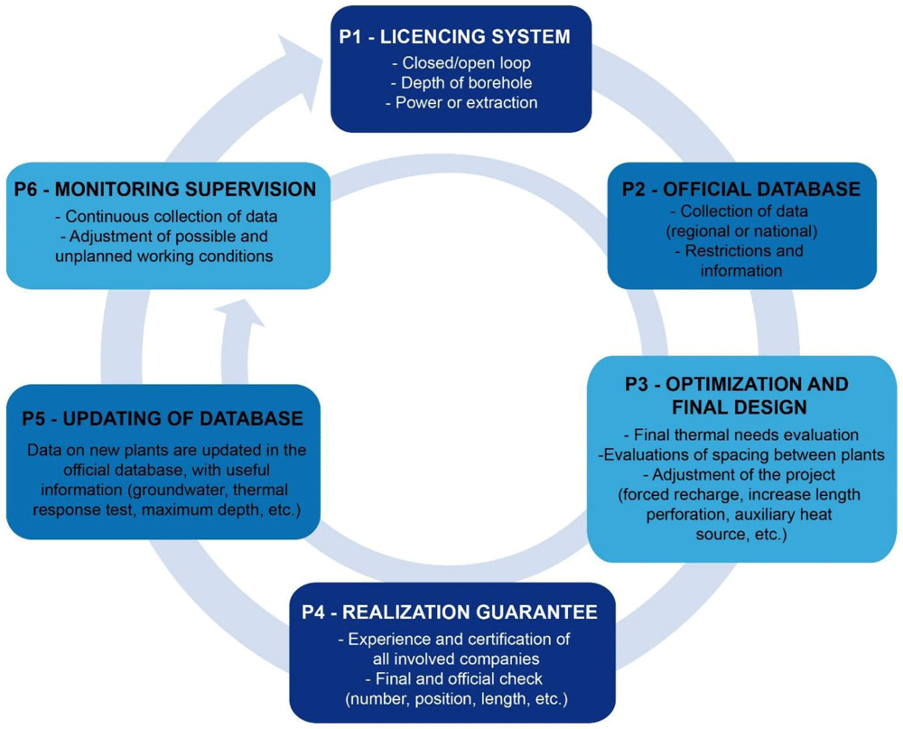
Figure 2. Conceptual model (CM) considering the complete and ideal phases for the realization of a ground source heat pump system.
The conceptual model was then applied to the GEO4CIVHIC virtual and real case study sites with a semi-qualitative approach14. The possibility to apply the model on case studies located in different European countries and frameworks allowed bringing to light more critical points to consider in the European policy to prevent future thermal interference effects.
A conceptual model for geothermal planning
As mentioned in 8, since 1999 “how sustainable is shallow geothermal energy?” has been a question needing to be answered. Thanks to the monitored data, the importance of the correct sizing was stressed as a fundamental aspect8. At that time, the importance of the cooperation between different stakeholders and people involved operating in the geothermal sector already appeared clear, as well as the presence of straight politics at European level. Specific software for simulation was already used to counteract the mutual influence in heat extraction, providing longer probes lengths in the case of dense buildings11.
Knowledge of the geothermal potential of an area is very useful to sustainably exploit shallow geothermal energy15 and to perform technical and economical pre-feasibility assessments for new systems16. Planning with an integrated strategy is also necessary to manage conflicts between resources in the urban planning of the underground17.
Clear regulations are necessary to implement and realize the BHE systems18–20. The licencing system should be as simple21 and centralized as possible in such a way as to facilitate end-users interested in installing BHE systems. For large systems, a more complex authorization is more appropriate, including risk assessment, environmental impact assessment, authorization and subsequent monitoring22. The presence of a public platform or geographic information system (GIS) based map can be very useful12,19,21,23,24. Some countries (e.g., Netherland and Switzerland) propose the definition of different areas based on the energy demands of the buildings to manage future installations25. Measures need to be taken to prevent thermal interference in densely populated areas that take into account the presence of neighbouring boreholes during the design phase9. In addition, some GIS based methods to estimate the technical potential of BHE systems considering potential thermal interference have been developed26,27.
In some cases, simulation of BHE systems11,28 and regeneration could be a way to prevent interference29–32. Monitoring should be implemented21,33 in order to observe if the system is operating as planned and, if not, allow any correction or changes to be made. The updated Swiss standard12 also underlines the importance of measurements, which should observe the thermal behaviour of the BHE over time, allowing it to be optimised if needed.
The diagram in Figure 1, brings together information from different publications and groups them into macro-areas, emphasising that very different aspects (regulation, planning/management, technical aspect) have a direct impact on the possible thermal interaction between geothermal systems. The diagrammatic representation of the review analysis aims to systematically describe the topics that should be introduced, at a regional or national level, for an efficient management of GSHP systems.
Based on the review analysis, and as described in the previous report underlying this work14, it was possible to highlight key points that have been simplified and integrated to propose a circular licensing system as a 6-phase conceptual model (Figure 2). The circularity nature shows the connection between the steps and demonstrates that, if any conditions are not compatible with the previous steps, the process must be repeated. As an example, if the monitoring (P6, Figure 2) shows parameters out of the range addressed in phases 1 to 5 (e.g., temperatures or heating requirements) it is necessary to check that the licensing system requirements for the operating system are respected.
The P1-Licencing system is necessary to check if the project fits the existing requirements, which should be clear, rigorous, and inclusive of all relevant aspects for the BHE system installation process. The licencing system should be simple and not too onerous or, at least, not too onerous for smaller systems that normally have a small thermal impact. It should also consider all relevant aspects in the field of interference. To avoid misunderstandings between private individuals, professionals and public administrations, the system should be coherent and approved at least at national level, whilst its management can be delegated at regional level.
During the second phase, the P2-Official database, the data collected in the first phase (licensing system) should be uploaded in a common geo-localized database to facilitate improved territorial management of the BHE systems. This database should be implemented, managed, and maintained by national or regional public offices, depending on the specific regulation. The geo-localized database allows the valorisation of information, an increase in knowledge and reduction in data gaps, a better monitoring of deployment trends of BHE systems, prevention of interference and clear guidance for GSHP systems in areas where legislative restrictions occur. This database makes the diffusion of the system more efficient and rapid, increasing awareness and management of past and future installations. According to the Swiss standard12, GIS are fundamental for the sustainability of every BHE project and the necessary data are: drilling location, depth, expected annual amount of energy extracted and annual amount of heat injected.
The third step is the P3-Optimization and the final design phase: an optimal system simultaneously allows the temperature of the heat transfer fluid and the minimum number of BHE installed to be satisfied simultaneously. The optimization of the system must, therefore, make it as efficient as possible, from an economic, energetic, and from an environmental standpoint. The thermal requirements must be accurately estimated and it must remain the same over the years, or in any case, their modification should not penalize the overall functioning of the system, in order to ensure a long-term system operation. Moreover, the number and layout of drillings is a fundamental parameter to correctly evaluate the geothermal system operation. The presence of drillings close to the property boundaries can in fact increase the probability of thermal interference with neighbouring systems in dense urban areas12. Finally, where other geothermal plants are in the proximity, it is necessary to evaluate solutions that can cancel or limit the negative effects of thermal interference between plants.
The fourth step is the P4-Realization guarantee: once the technical aspects are defined, one of the steps that is often missing is a verification that the project is carried out and installed as described, and therefore all the specifications considered during phase 3 are put into practice. The realization guarantee can be verified in two ways. The first is that the companies responsible for the construction and installation of the system, are certified or that they are able to carry out the work using state of the art methods (this aspect can be improved through training of professionals with regular courses and updates in techniques and construction materials). The second is that competent authorities verify, during the construction phase, that the implementation is realized according to P1.
The fifth step is the P5-Updating of database: during the drilling and construction phase, variations in the original project planned due to unforeseen ground conditions occur. Impediments related to some geological or aquifer water pressures issues may force the length, number or location of the perforations to be reconsidered. For these reasons, updating the information on the databases, after the implementation phase is essential to ensure that the correct data is present. When the data is not updated, the information in the database remains incorrect and consequently erroneously influences future considerations on the planning and recommendation for deploying GSHP systems.
The sixth phase is the P6-Monitoring phase,where any discrepancies from what was initially planned emerge. If, during the operational phase, the planned conditions are not respected, it is possible to subsequently adapt the system and to repeat the licensing procedure (P1) evaluating the compliance with the regulations and the subsequent steps. For large BHE systems, monitoring equipment that tracks at least the forward and return temperatures from the probes and the thermal regeneration of the ground has to be taken into account12.
Application of the model to the real and virtual cases
Within the framework of the GEO4CIVHIC project, 16 case studies, located in several European countries, were examined (Figure 3).
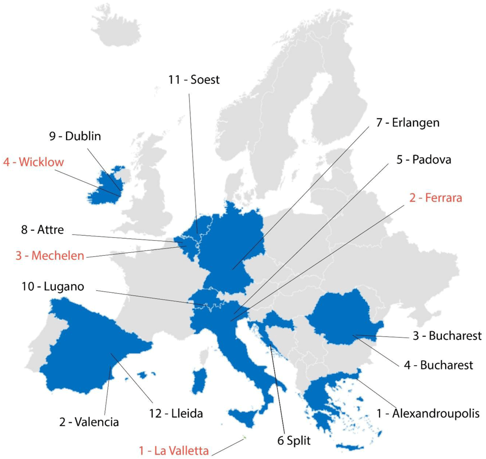
Figure 3. Maps of the real (written in red) and virtual (written in black) case studies of the GEO4CIVHIC project.
Each one of the four real and 12 virtual case studies were analysed and assessed using the proposed 6-phase conceptual model (Figure 2). For the details of the single case studies, see chapter 2 of the deliverable D6.3 of the GEO4CIVHIC project14, where each case study is described.
Each phase of the conceptual model was assessed for each case study and a score from 0 to 3 (with 0 = not implemented at all, 3 = completely implemented) assigned. Specifically, if the phase is only partially satisfied, but can be significantly improved, then the score assigned is 1 (as an example, a database not precisely geolocated and not easily accessible); if the phase is performed, but can still be improved, the score is 2 (as an example, a geolocated, structured and constantly updated database, but that lacks easy access, because the database is not public); if the step is performed completely and optimally, the score is 3 (as an example, a reliable and geolocated database, which contains a lot of additional useful information public and easily accessible). Figure 4 shows real and virtual case studies, for details of the single case studies, see deliverable 6.314.
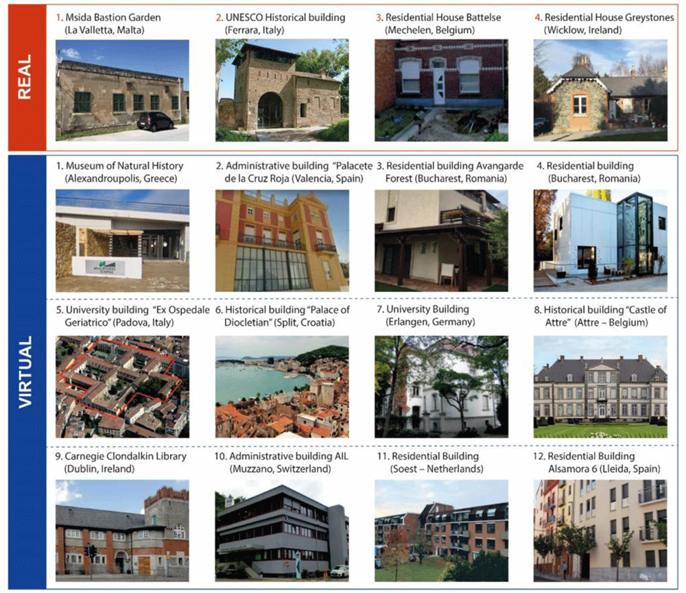
Figure 4. Real and virtual case studies of the GEO4CIVHIC project.
A percentage was then obtained for each step. This indicates the level of detail to which a phase is performed (general or in-depth) for each of the case studies analysed.
The results obtained from the application of the model are shown in Figure 5, which describes an overall framework of the situation at each case study site. More details on the data used and underlying this figure are available in 14.
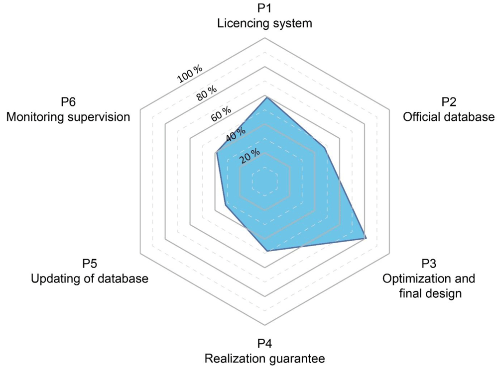
Figure 5. Results of the application of the model to the GEO4CIVHIC case studies.
Many interesting aspects emerged by analysing the different real and virtual buildings located in several countries. However, it is not possible to generalize at national level, as the license systems can be at national, regional, or municipal level with different conditions and requirements, even in the same country.
The results based on the 16 cases show that typically the best addressed phase is the "optimization and final design” phase (P3, Figure 5).
The licencing or permit system (P1, Figure 5) represents the second-best addressed phase (58%). However, even if many countries show that usually a general licencing system is present, the assessment has noted that sometimes these generic systems lack specific or clear licencing procedures especially for closed-loop systems. In addition, the drilling permission is not always required. This leads to a lack of knowledge of existing and future installation that prevents the implementation of adequate management and planning strategies that can promote the suitable development of resources.
When considering the possible interference prevention between neighbourhood systems, the results of the analysis from the 16 case studies shows that a minimum distance between plants is not always defined. The reason in some cases is that there was no clear legislative requirement for defining such distance. In some other cases, the use of adequate design tools and methodologies to optimise the planning and specification of the systems are not used (a detailed description of each case study with criticalities and strengths is available in 14). This lack of specific rules or tools about the interference, sometimes lead to unwritten rules which vary from case to case, and it risks them being inconsistent, or in any case leads to results that are not always easily assessable or demonstrable. Furthermore, not having defined and specific rules and regulations on this topic, implies that specific analyses of possible interferences are not required and therefore are not carried out.
The realization guarantee (P4, Figure 5) resulted in a score of 49% and the presence of a database (P2, Figure 5) a score of 46%. The realization guarantee (P4, Figure 5) along with the database (P2, Figure 5) are often missing and where these exist, the information is not publicly available. When present, the database management is implemented at different levels (national, regional, municipal). The lack of a database does not allow knowledge of the location and lengths of single drillings associated with GHSP systems. This hinders the realization of future new plants and the ability to manage new and previous installations. Moreover, it is almost impossible to find information on previous installations, hence once the localisation of a single BHE is lost, a significant data gap in the future management and planning of resources is generated.
Finally, the monitoring phase (P6, Figure 5) results are 40% and the update of the database (P5, Figure 5) 33%. The monitoring phase (P6) is rarely present. Generally, the monitoring is considered expensive, and if the licencing system does not require this to be performed, it is not completed (especially for a closed loop systems). In other cases, monitoring is simply performed for control and to ensure that the system is performing adequately, but no historical data is collected or stored to facilitate further in-depth analysis.
The database update (P5, Figure 5) is the phase with the worst score, in some cases because there is no database at all (P2, Figure 5), in others, because the final data are not reported or updated. The database update is important because data inserted at P2, during the planning, can differ from the real data after the final implementation and should be updated (as an example, changes on the number of the drillings, on their length and position can significantly influence the overall thermal physics in the subsoil).
Conclusions
The deployment of geothermal heat pumps within Europe is extremely heterogeneous from one country to another; sometimes it is very different even between regions of the same country. In this context, thermal interference is not usually well known or addressed. Usually, it is also influenced by the presence or absence of a licensing system, procedures, management of existing data and an approach not based on the planning of installations, especially in dense urban areas, where interference problems can produce long term effects in systems operation.
A literature review highlighted three main aspects that are fundamental to preventing thermal interference problems: regulation, planning/management and technical aspects.
Thanks to the reworking of the review and to data from the GEO4CIVHIC project, a 6-phase conceptual licensing flow chart was created. This diagram represents a guideline to identify weaknesses in the planning process and final realization of a BHE, giving suggestions on how to improve the specific (national, regional, or municipal) systems to prevent interference. The 6 steps are: (P1) the presence of a licensing system; (P2) the availability of an official GIS database; (P3) the technical optimization and final design phase; (P4) the realization guarantee through certification of companies involved and the final check from administration; (P5) the database update, important to have consistent and reliable data and information for future realization; (P6) the monitoring which allows finding problems in the operation in order to adjust them.
The 6-phase flow diagram (Figure 2) was applied to 16 real and virtual case studies from different European countries included in the GEO4CIVHIC project to analyze how the different steps were addressed in different contexts and giving a score according to how many of the aspects of each phase were satisfied or present. The application of the conceptual licensing system model to the case studies showed that the optimization and final design phase (P3) was the step which received the highest score. This result reflects the great effort performed by technicians and specialists to improve the functioning of a geothermal system. Unfortunately, even if the optimization and final design are well implemented, the failures in the previous or following phases can jeopardize the overall procedure, leading to potential future thermal interferences between different systems.
The analysis of the case studies led to the following general considerations:
● regulation requires the presence of centralized and simplified administrative processes, more structured authorization, especially for large systems, and a good integration of different procedure levels (national/regional);
● an updated, public GIS platform, which stores and allows the visualization of collected data, including characteristics of specific installations and their thermal needs, would allow for better planning and management of existing and future installations;
● to prevent interferences, it is important to use specific tools which can simulate the long-term sustainability of the geothermal system before its realization. Those specific tools allow for the calculation and simulation of complex cases that can occur and that cannot be foreseen using simple “unwritten rules”.
The application of this 6-step model was useful to understand where there are critical aspects in specific case studies and how these can be best addressed to try and prevent long term thermal interference between systems as well as identifying different stakeholders that can help prevent this.
The results of the case study analysis showed that one of the key shortcomings is the lack of information on data (location, length, number of drillings). An official database is usually missing and sometimes only the companies have detailed knowledge of these basic data. The final data in the database sometimes only shows the project data (and not the final implementation data). For this reason, the data might not show the right position and layout of BHE systems.
Through a reliable database, where information is digitised and geo-referenced in a public portal, the management of geothermal systems could become easier in the present and in the future. It is important that data are entered correctly during implementation because, unlike other technologies such as photovoltaics, solar thermal, wind or hydro, which can be easily detected later e.g. using remote sensing or other techniques based on high-resolution image recognition, shallow geothermal systems are difficult to detect after installation due to their low visual impact. Policy should provide rules that favour such data collection and sharing to promote the long-term sustainable development of geothermal technology especially in dense urban spaces.
This 6-step conceptual model is a method that can be extended to all shallow geothermal systems for long-term planning. The methodology has to be applied considering the peculiarities of the context, such as national and local standards, the presence or absence of a database, stakeholder involvement and knowledge. The lack of a regulatory framework in some locations is one of the main barriers to successful implementation of geothermal energy systems. The application of the method allows a systematization of the local framework and facilitates the identification of possible strengths or weaknesses in order to improve the local energy planning strategy.
Data availability
Source data
This study involves a literature review and a case study which were used to present results in an existing report available from 14 and also from https://doi.org/10.3030/792355 (see section “Documents, reports”).
Ethics and consent
Ethical approval and consent were not required
Faculty Opinions recommendedReferences
- 1.
European Geothermal Energy Council - EGEC: 2020 EGEC Geothermal Market Rreport Key Findings. 2021. Reference Source
- 2.
Lund JW, Toth AN:
Direct utilization of geothermal energy 2020 worldwide review.
Geothermics.
2020; 90: 101915. Publisher Full Text
- 3.
European Heat Pump Association - EHPA: Heat pump sales overview. 2021.
- 4.
SITRA: Ground source heat pumps, Stockholm. 2021. Reference Source
- 5.
EU Commission: Directive 2012/27/EU of the European Parliament and of the Council of 25 October 2012 on energy efficiency, amending Directives 2009/125/EC and 2010/30/EU and repealing Directives 2004/8/EC and 2006/32/EC. Official Journal of the European Union. 2012. Reference Source
- 6.
EU Commission: Directive 2018/2001/EU of the European Parliament and of the Council of 11 December 2018 on the promotion of the use of energy from renewable sources. Official Journal of the European Union.2018. Reference Source
- 7.
Turkson C, Acquaye A, Liu W, et al.:
Sustainability assessment of energy production: a critical review of methods, measures and issues.
J Environ Manage.
2020; 264: 110464. PubMed Abstract
| Publisher Full Text
- 8.
Sanner B:
Prospects for ground-source heat pumps in Europe.
IEA Heat Pump Newsletter.
1999; 17(1): 19-22.
- 9.
Fascí ML, Lazzarotto A, Acuna J, et al.:
Analysis of the thermal interference between ground source heat pump systems in dense neighborhoods.
Science and Technology for the Built Environment.
2019; 25(8): 1069-1080. Publisher Full Text
- 10.
GEO4CIVHIC project, received funding from the European Union’s Horizon 2020 research and innovation programme under grant agreement No. 792355. Reference Source
- 11.
Knoblich K, Sanner B, Behr W:
Neubaugebiete mit Erdwärmesonden in Werne und Dortmund-Mengede.
Geothermische Fachtagung Herne.
Bd. Tagungsband 6. 2000. Reference Source
- 12.
Schweizerische Ingenieur und Architektenverein – SIA. SIA 384/6: 2021. Erdwärmesonden. In German.2021.
- 13.
Verein Deutscher Ingenieure (VDI): VDI 4640 Sheet 2. Thermal use of the underground. Ground source heat pump systems.2019.
- 14.
Belliardi M, Pasquali R, Sanner B, et al.:
D6.3 Reccomandation for the planning and implementation of new GSHP systems in dense urban environments and related tool. D6.3 GEO4CIVHIC. 2020; [last accessed: 01.02.2022]. Reference Source
- 15.
Kohl T, Rybach L, Baujard C, et al.:
Geothermische Energie im Kanton Zürich.Baudirektion Kanton Zürich, Zürich Switzerland. In German, 2007. Reference Source
- 16.
Perego R, Pera S, Galgaro A:
Techno-economic mapping for the improvement of shallow geothermal management in southern Switzerland.
Energies.
2019; 12(2): 279. Publisher Full Text
- 17.
Li H, Li X, Soh CK:
An integrated strategy for sustainable development of the urban underground: From strategic, economic and societal aspects.
Tunnelling and Underground Space Technology.
2016; 55: 67–82. Publisher Full Text
- 18.
Dörig L:
Das Recht zur Nutzung der Erdwärme. Dike. In German, 2019. Reference Source
- 19.
SvizzeraEnergia: Procedure di autorizzazione nei diversi Cantoni per l’installazione di sonde geotermiche verticali. In Italian, 2017; [last accessed: 15.02.2022]. Reference Source
- 20.
Abegg A, Dörig L:
Das Recht und die Regulierung von Erdwärme. Jusletter, In German. 2017; 1–8. Reference Source
- 21.
Somogyi V, Sebestyén V, Nagy G:
Scientific achievements and regulation of shallow geothermal systems in six European countries–A review.
Renewable and Sustainable Energy Reviews.
2017; 68: 934–952. Publisher Full Text
- 22.
Pasquali R, O'Neill N:
D3.4 Recommendation guidelines for a common European regulatory framework. ReGeoCites, Co-funded by the Intelligent Energy Europe Programme of European Union. 2015.
- 23.
Bébié B, Jakob M:
Wärmeversorgung: potential der Quartiere. TEC 21, 12/2012. In German, 2012.
- 24.
Poppei J, Wilhelm C, Gischig V, et al.:
Überprüfung der Auslegungskennwerte zur strategischen Planung von Erdwärmesonden. Anwendungsbeispiele des grundstücksflächenbezogenen Wärmeentzugs. CSD Ingenieure AG im Auftrag des Bundesamts für Energie, EnergieSchweiz. In German, 2019.
- 25.
Witte HJ:
A novel tool for assessing negative temperature interactions between neighbouring borehole heat exchanger systems. Proocedings of the 14th international conference on energy storage - EnerSTOCK2018, Turkey. 2018. Reference Source
- 26.
Miglani S, Orehounig K, Carmeliet J:
Integrating a thermal model of ground source heat pumps and solar regeneration within building energy system optimization.
Applied Energy.
2018; 218: 78–94. Publisher Full Text
- 27.
Walch A, Mohajeri N, Gudmundsson A, et al.:
Quantifying the technical geothermal potential from shallow borehole heat exchangers at regional scale.
Renewable Energy.
2021; 165: 369–380. Publisher Full Text
- 28.
Knüsel P:
Erdwärmesonden im Dichtestress. TEC21 9-10/2015. In German, 2015.
- 29.
Wagner R, Weisskopf T:
Erdsondenpotenzial in der Stadt Zürich. Im Auftrag des Amtes für Hochbauten der Stadt Zürich. In German, 2014.
- 30.
Persdorf P, Ruesch F, Haller MY:
RegenOpt Optionen zur Vermeidung nachbarschaftlicher Beeinflussung von Erdwärmesonden: energetische und ökonomische Analysen. Amt für Hochbauten der Stadt Zürich, Zürich. In German.2015.
- 31.
Pahud D:
Haute densité de sondes géothermiques - Calcul des effets à long terme d’installations géothermiques dans un quartier.2017; [last accessed: 17.03.2022]. Reference Source
- 32.
Miglani S, Orehounig K, Carmeliet J:
A methodology to calculate long-term shallow geothermal energy potential for an urban neighbourhood.
Energy and Buildings.
2018; 159: 462–473. Publisher Full Text
- 33.
Fascì ML, Lazzarotto A, Acuna J, et al.:
Thermal influence of neighbouring GSHP installations: Relevance of heat load temporal resolution. Proceedings of the IGSHPA Research Track 2018. 2018. Publisher Full Text