Introduction
Geological indicators of past sea levels are fundamental to assessing how ice sheets melted in the past and provide fundamental benchmarks to define possible scenarios of ice sheets melting in a warmer future climate1. To be used as a sea level index point (SLIP, also called “relative sea-level indicator“), a geological feature must be assigned an elevation and geographic location, an age via radiometric dating or chronostratigraphic correlation, and must have a quantifiable relationship with a former sea level, called indicative meaning2. Knowing these three parameters, it is possible to reconstruct the relative sea level (RSL) at a point in time in the past. In turn, RSL corresponds to the sum of global mean sea level and post-depositional land motions caused by different processes (e.g., tectonics, glacial isostatic adjustment, sediment compaction3).
The advent of data digitalisation has provided paleo sea-level researchers with new opportunities to discover and access studies from different research groups. Among the tools facilitating the exchange of information, scientific articles and open-access repositories have opened the possibility to download, analyse and in some case visualize4 sea-level data to anyone with internet access. However, access to new studies and data comes with additional challenges. A widespread issue is that the information related to sea-level indicators is communicated in multiple ways (e.g., graphs, tables, in-text explanations, supplementary information) that require readers to navigate among different styles and conventions. Sea level researchers often face additional challenges as a correct interpretation of data requires an understanding of several measurement and dating techniques, and requires in-depth knowledge of how the original information (e.g., the stratigraphic context of geological sea-level index points) was interpreted by the authors. Recent efforts among the sea-level research community have resulted in standardised formats designed to store and share information on sea-level indicators in a way that allows different researchers to understand the origin and details of their measurements and reproduce the process to extract their components5,6.
The World Atlas of Last Interglacial Shorelines (WALIS) is a standardised database that includes data from thousands of studies published since the early 1900s. The focus is on sea-level indicators formed during the Last Interglacial (~80 to 130 ka), although the database includes some older data points7. The database includes 4545 sea-level proxies and 4110 dated samples standardised from 2130 references compiled by multiple research groups within a special issue of the Earth System Science Data journal. The structure of the database consists of multiple tables, that are openly available in Zenodo8 in different export formats (e.g., CSV and geoJSON). In this work, we present a dashboard that allows exploring WALIS data, and can be used both offline and online. The basic use of the dashboard does not require downloading the database or extensive coding knowledge.
The WALIS Dashboard
The main purpose of the WALIS Dashboard is to provide an alternative entry point for end users to explore the information included in WALIS. We note that our use of WALIS falls within the license under which the database is shared (CC-BY 4.0). The WALIS Dashboard was originally coded in the framework of the master thesis of Sebastián Garzón9. The first version (ver. 1.0) of the WALIS Dashboard was released in 202110. The second version (ver. 2.0) was released at the end of October 202211 and is briefly outlined within the WALIS database description paper7. For the peer-review of this manuscript, we prepared version 3.0, which includes bug fixes and improvements to the interface12. Post-review, we released version 3.113 , which considers the reviewer’s comments and proposes further improvements to the interface.
The WALIS Database
The WALIS Dashboard is based on a simplified, single-table version, of the WALIS database (called Summary Table), which is included (together with the code used to generate it) in the WALIS database repository (see Underlying data). This table is created from the “Summary sheet” included in WALIS, calculating percentiles of the probability distribution for paleo RSL and age (0.1,2.3,15.9,50,84.1,97.7 and 99.5 percentiles). The RSL percentiles for each SLIP are calculated by applying, to each index point, the following procedure:
1. If the SLIP is a "Single Coral", the percentiles are obtained from a gamma function interpolated considering the upper limit of living range inserted in the database as, respectively, the 2.3 and 97.7 percentiles of the distribution.
2. If the RSL Indicator is a "Sea Level Indicator" or "Single Speleothem": the percentiles on paleo RSL are calculated from the Gaussian distribution represented by the field "Paleo RSL (m)" and its associated uncertainty (1-sigma).
3. If the RSL Indicator is a "Terrestrial Limiting" or "Marine Limiting", the RSL percentiles are not calculated.
For which concerns age percentiles, for SLIPs with radiometric ages they are calculated from the Gaussian distribution of the mean age and its associated 2-sigma uncertainty. In case the age of the SLIP is present in WALIS only as a time period (e.g., the SLIP is attributed to Marine Isotopic Stage 5), the age range is treated as a uniform distribution, with upper and lower age limits matching those indicated by Lisiecky and Raymo (2005)14 and Spratt and Lisiecky (2016)15, that are already coded into WALIS (e.g., a MIS 5 age assignment corresponds to an age range between 71 and 130 ka).
Rationale and software description
WALIS is a complex database framework, as it includes several tables connected by several SQL relations (see Rovere et al., 20237 for a detailed description of the database). Traditional access to WALIS for end-users would require them to directly download the full dataset from Zenodo or connect to the SQL server that hosts the database. Given the complexity required to standardize SLIPs, these tasks would require end users to familiarize themselves with the dataset structure and with either Python or SQL to explore, visualize, or perform data analysis on the database. While the WALIS distribution8 includes Python scripts to perform simple queries on the data, end-users would still need a good proficiency level in Python to use and modify these scripts to their needs. Given the challenges described above, we created the WALIS Dashboard to allow for a quick exploration, query, and analysis of the SLIPs included in the database. The WALIS Dashboard software architecture is described hereafter and the software is available for open access (see Software availability).
The WALIS Dashboard is an interactive application developed using open-source R packages. The software was developed using R (RRID:SCR_001905) version 4.1.016. The application is built using the R-Shiny package (RRID:SCR_001626)17 that allows the integration of data visualization and analysis in an interactive web platform. The application includes individual data visualisations often used in the literature to provide context on SLIPs, such as maps, sea-level plots, and tables. Additionally, the application provides the end users an interface to apply a Monte Carlo method9 to merge and summarise multiple SLIPs within the same geographic context.
The WALIS dashboard can be accessed both online and offline. The online version is available as a freely-hosted shiny app here (Last access January 30th, 2024). We coded the online application targeting end-users who want to explore the WALIS data set without installing any R package or manipulating code. Access to the online version only requires a stable internet connection. The dashboard can be also accessed in a local build after downloading the source code available on our GitHub repository or in the Zenodo repository12. The target for the offline version is researchers who want to contribute to expanding the capabilities of the dashboard, or who need to run more computationally intense data analyses. Contributions are welcome as new issues or pull requests in the main GitHub repository.
Main features
The application is divided into three tabs: "Interactive map", "Summary table", and "Merge SLIPs" (Figure 1). These are described hereafter one by one, but we remark that the operations (e.g., filtering) done on the data in one tab are propagated to the other ones.
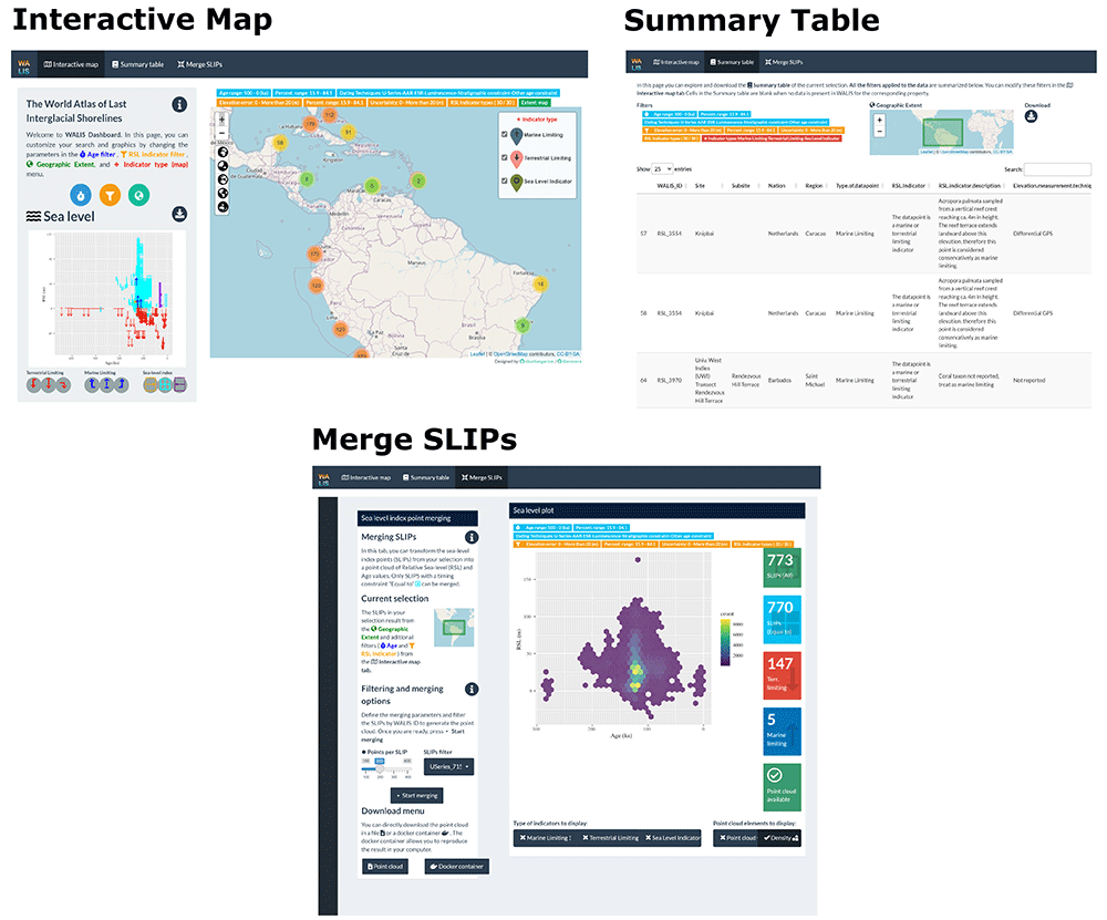
Figure 1. WALIS Dashboard interactive tabs.
Interactive map
The starting page of the WALIS Dashboard is divided into three main parts: a filtering application, a map, and a sea-level plot. The filtering application allows querying the data through age properties (age range with user-specified percentile bounds and dating technique, SLIP properties (elevation error, RSL uncertainty and associated percentiles, and type of RSL indicator), and geographic extent (either gathered from the map display or via a polygon drawn by the user). The map shows the location of the SLIPs included in WALIS. Clicking on one point in the map, a popup menu appears with general information about the selected record. As a default, when panning and zooming onto the map the sea-level plot is updated. The sea-level plot shows RSL on the Y-axis and Age (ka) on the X-Axis and is the main element of data visualisation in the "Interactive map" tab. Based on the filters applied to the data, the graph is updated in real time. In the graph, we implemented a symbology for the nine types of sea-level indicators and associated ages allowed by the WALIS database7. The sea-level plot can be downloaded in PNG format.
Summary table
The second tab in the WALIS dashboard is called "Summary table" and includes the data as filtered in the "Interactive map" tab. As a visual guide, on the top of the page, two insets show the current filters active on the data and a map that defines the area of interest. The table displayed on this page includes all the information available from the simplified version of WALIS described in the previous sections. In the upper right corner of this page, a button allows downloading the data in CSV format.
Merge SLIPs
The "Merge SLIP" tab allows the end-user to create a point cloud or density plot that represents a probability distribution of RSL vs age, using the SLIPs that were selected in the "Interactive map" tab. In this tab, the end-user can combine the different probability distributions of Age and RSL values of each sea-level index point (SLIP) into a single point cloud. Before merging the data, the user can further filter the dataset (by excluding selected index points) and determine the number of points to be sampled within each SLIP.
The merging method follows the methodology proposed by Garzón (2022)9, which was adapted from the work of Bender et al. (2020)18 (code available in Rovere et al., 202019). The method consists of a Monte Carlo sampling of RSL and Age for each SLIP within their probabilistic distributions (Figure 2). In the WALIS Dashboard, the end-user can select how many times per SLIP the workflow shown in Figure 2 is repeated. The WALIS Dashboard limits the number of points per SLIP depending on the number of SLIPs selected for the analysis. Analysis including a large number of samples can be performed by downloading a docker container from the “Download” menu after merging a selection of SLIPs.
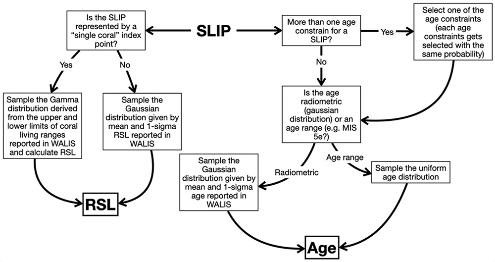
Figure 2. Overview of the processing done on each SLIP within the WALIS Dashboard at each run of the Monte Carlo processing.
After the SLIPs are merged, the user can explore the results in a RSL vs Age plot. The results can then be exported using two different strategies: "Point cloud download" or "Docker container". The first option exports the resulting point cloud into a CSV file accompanied by a geoJSON file with information about the filters used. The second option creates a docker image accompanied by the required data and code to fully reproduce the results of the data merging. In this way, the results obtained remotely in the Dashboard are fully reproducible on a local machine.
Operation
System requirements
The WALIS dashboard is available both online and offline. The online version only requires a stable internet connection to access the interactive web app. To guarantee the long-term availability of the application, here we explain two alternatives to deploy the application on a local machine.
Local shiny application
Users can deploy a local implementation of the shiny application using the {renv} package. This option provides the required files and R packages information. An R installation is a prerequisite for this option.
1. Download the WALIS dashboard from GitHub - see Software availability
2. Open R and install the renv package.
3. Open the R Project file (WALIS_Visualization.Rproj). This file should start the process of restoring the dependencies of the project using the Lockfile (renv.lock). You can manually restore the dependencies using the function restore() from the R package renv
library("renv")restore(renv.lock)
4. Open the app.R file.
5. Run the App using the runApp() function from the Shiny R package.
Docker image
A Docker image to run the application is available as part of the application. This docker image allows the application to be fully reproducible as the instructions and computational requirements (e.g., operating system, R packages) to deploy the application inside a software container are automated. The only prerequisite is to have Docker () installed and running on the local machine.
Download and start-up instructions - Docker
1. Download the WALIS dashboard from GitHub - see Software availability
2. Open Docker to run in the background
3. Open a terminal and access the folder with the application
4. Create a Docker container using the Dockerfile image. This process could take hours the first time as it requires setting up all computational requirements.
5. Run the Docker container
6. Open the application in a web browser at http://localhost:3838
Use case
In the following sections, we use the WALIS Dashboard to test a simple hypothesis using RSL data included in WALIS. We want to test the hypothesis that across the island of Curaçao there is a long-term North-South tectonic tilting, similar to the one already suggested for the nearby island of Bonaire20,21. If present, such tilting should be evident from the paleo RSL record on Curaçao (that is, the local sea-level indicated by SLIPs across the island, uncorrected for any post-depositional displacement).
Step 1 – Data query
The first step is to verify that data is present for the island of Curaçao, in the Lesser Antilles. This is done by panning and zooming on the map to the island. From the WALIS Dashboard, we can verify that there is data across large parts of the island, mostly on its Northern, Central, and Central-Southern parts (Figure 3A). The data spans a large age range (~80-160 ka) and indicate that RSL could have attained elevations between 0 and 20 meters above present (Figure 3B). For our work, we want to limit the age of the SLIPs to Marine Isotope Stage 5e, i.e., 110-130 ka), and we want to discard marine limiting points (i.e., points that indicates that sea-level was above the measured feature, but for which no relation with the former sea-level is provided). We therefore filter our data using the "Age filter" menu to keep only the desired age range, and we turn off from the legend in the main map the "Marine Limiting" points.
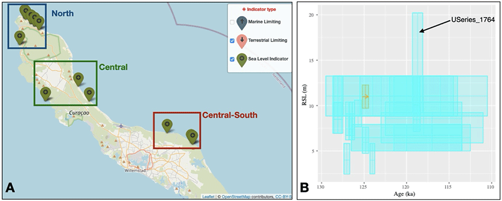
Figure 3.
A) Map and B) RSL vs Age plot from the WALIS Dashboard for the island of Curaçao after the filtering described in the text. The datapoint labelled in B) has been excluded before merging the SLIPs, as described in the text.
Step 2 – Database Exploration
From the "Summary Table" page, we can explore the data and see what literature sources are present. The data in this area has been inserted in the WALIS database by two studies, Chutcharavan and Dutton (2021)22 and Rubio-Sandoval et al. (2021)23, who reviewed the works of Schellmann et al. (2004)24 and Muhs et al. (2012)25. The full references to these studies are present in the full version of WALIS8. In total, in Curaçao, there are 26 SLIPs with ages between 130 and 110 ka, most of them concentrated in the North (n=18), the others in the Central (n=4) and Central-South (n=4) sub-areas (Figure 3A).
Step 3 – Merge SLIPs
We use the geographic filter option to select and export (via the "Summary Table" page) one CSV file for each sub-area shown in Figure 3A. For each sub-area, we then use the "Merge SLIP" function to create a point cloud describing the probability distribution of RSL and age in each sub-area. We use a sample of 10.000 points per SLIP in each area. For each sub-area, we download both the point cloud and the docker container. In the Central-South sub-area, we exclude from merging the index point labelled as "USeries_1764" (labelled in Figure 3B), which is characterized by very large error bars, and therefore may be unreliable.
We then use the exported point cloud within a graphic software to explore in detail the trends in the data (Figure 4A-C). From the histograms of RSL in each area (Figure 4D), we verify that there is an overlap between the RSL records in the North, Central, and Central-South areas. However, the first and third quantiles of the distribution show that, in the North, RSL is slightly higher (6.5-10.3 m) than in the Central (6.1-8.9 m) and Central-South (5.4-7.4 m) parts.
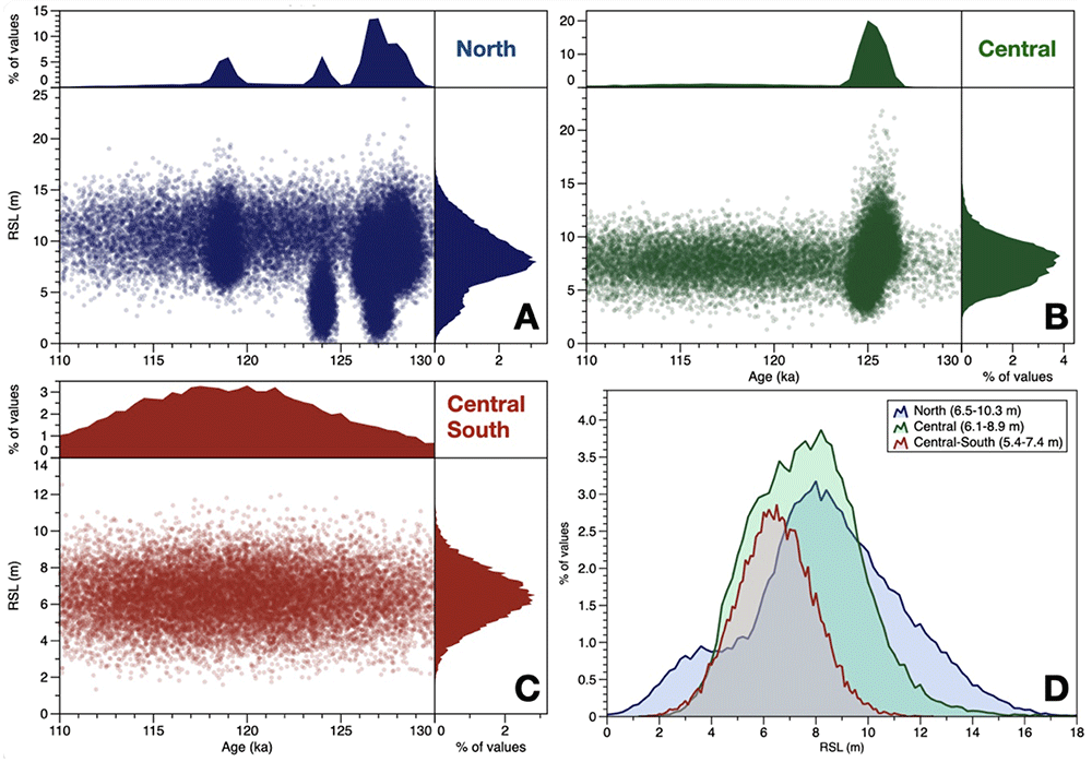
Figure 4.
A-C) Plots showing the point clouds expoted from the WALIS Dashboard after the "Merge SLIP" processing. The upper and right panels show the histograms of, respectively, age and RSL derived from the point clouds. D) Histograms of RSL for each of the three areas. Within the legend, in parenthesis, are indicated the first and third quartile of each histogram.
Therefore, the WALIS Dashboard allowed us to extract the data to test a simple hypothesis on the North-South tilting of the island of Curaçao. Standing the results, the hypothesis is rejected, as there is no significant difference between the probability distribution of RSL across the island. However, the data also suggests that there might be some differences (as per the quartiles shown in Figure 4D), therefore highlighting the need for more precise in-situ surveys across the island to gauge whether these differences might reflect a different post-depositional deformation signal across the island.
Conclusions
In this article, we presented an open-source online dashboard developed using R packages to explore the WALIS database. This dashboard is an example of how open-source tools can be used to simplify access to database information for research teams with limited software development or use capabilities. The interactive application consists of three tabs that summarise the database information for researchers to provide a user-friendly point of connection to the information. The application includes basic data processing methods that provide meaningful observations for researchers to start analysing the content of the database. Given the application design, end-users of the application should be able to easily explore the WALIS database before engaging in more complex and time-consuming tasks to understand the database structure. To promote further developments and guarantee the long-term and offline maintenance of the application, the software includes reproducibility strategies such as software containers and dependency management strategies. Similarly, the application is licensed under an MIT permissive free software license, to encourage researcher teams to implement similar interactive visualisation approaches for other databases.
Ethics and consent
Ethical approval and consent were not required.
Acknowledgements
We thank Dr. Kim Cohen for his valuable comments during the development of the visualisation tool.
Faculty Opinions recommendedReferences
- 1.
Golledge NR, Clark PU, He F, et al.:
Retreat of the antarctic ice sheet during the last interglaciation and implications for future change.
Geophys Res Lett.
2021; 48(17): e2021GL094513. Publisher Full Text
- 2.
Shennan I, Long AJ, Horton BP:
chapter 2, Handbook of sea-level research. John Wiley & Sons; 2015; 3–25. Publisher Full Text
- 3.
Rovere A, Stocchi P, Vacchi M:
Eustatic and relative sea level changes.
Curr Clim Change Rep.
2016; 2(4): 221–231. Publisher Full Text
- 4.
Drechsel J, Khan NS, Rovere A:
PALEO-SEAL: A tool for the visualization and sharing of Holocene sea-level data.
Quat Sci Rev.
2021; 259: 106884. Publisher Full Text
- 5.
Khan NS, Horton BP, Engelhart S, et al.:
Inception of a global atlas of sea levels since the last glacial maximum.
Quat Sci Rev.
2019; 220: 359–371. Publisher Full Text
- 6.
Düsterhus A, Rovere A, Carlson AE, et al.:
Palaeo-sea-level and palaeo-ice-sheet databases: problems, strategies, and perspectives.
Climate of the Past.
2016; 12(4): 911–921. Publisher Full Text
- 7.
Rovere A, Ryan DD, Vacchi M, et al.:
The World Atlas of Last Interglacial Shorelines (version 1.0).
Earth Syst Sci Data.
2023; 15(1): 1–23. Publisher Full Text
- 8.
Rovere A, Ryan DD, Vacchi M, et al.:
WALIS - The World Atlas of Last Interglacial Shorelines (Ver 1.0 final).
Zenodo. Published online November 2022. Publisher Full Text
- 9.
Garzón S:
A methodology to compare sea-level index points and sea-level models. Published online January 21, 2022. Publisher Full Text
- 10.
Garzón S, Rovere A:
WALIS visualization interface.
Zenodo.
Published online June 14, 2021. Publisher Full Text
- 11.
Garzón S, Rovere A:
WALIS visualization interface (Version 2.0).
Zenodo.
Published online 2022. Publisher Full Text
- 12.
Rovere A, Garzón S:
WALIS visualisation interface (v3.0).
Zenodo.
Published online June 7, 2023. Publisher Full Text
- 13.
Garzón S, Rovere A:
WALIS visualization interface (Version 3.1). Published online 2024. Publisher Full Text
- 14.
Lisiecki LE, Raymo ME:
A Pliocene‐Pleistocene stack of 57 globally distributed benthic δ18O records.
Paleoceanography.
2005; 20(1): 2004PA001071. Publisher Full Text
- 15.
Spratt RM, Lisiecki LE:
A Late Pleistocene sea level stack.
Clim Past.
2016; 12(4): 1079–1092. Publisher Full Text
- 16.
R Developement Core Team: R: A Language and Environment for Statistical Computing. Published online 2010. Reference Source
- 17.
Chang W, Cheng J, Allaire JJ, et al.:
shiny: Web Application Framework for R. Published online 2017. Reference Source
- 18.
Bender M, Mann T, Stocchi P, et al.:
Late Holocene ( 0–6 ka ) sea-level changes in the Makassar Strait , Indonesia.
Clim Past.
2020; 16(4): 1187–1205. Publisher Full Text
- 19.
Rovere A, Stocchi P, Bender M:
Models, data and python tools for the analysis of sea level data in the Spermonde Archipelago (version 2.2)..
Zenodo.
Published online October 11, 2020. Publisher Full Text
- 20.
Herweijer J:
Late Pleistocene depositional and denudational history of Aruba, Bonaire and Curagao (Netherlands Antilles).
Geol Mijnbouw.
1978; 57(2): 177–187.
- 21.
Lorscheid T, Felis T, Stocchi P, et al.:
Tides in the Last Interglacial: Insights from notch geometry and palaeo tidal models in Bonaire, Netherland Antilles.
Sci Rep.
2017; 7(1): 16241. Publisher Full Text
- 22.
Chutcharavan PM, Dutton A:
A global compilation of U-series-dated fossil coral sea-level indicators for the Last Interglacial period (Marine Isotope Stage 5e).
Earth Syst Sci Data.
2021; 13(7): 3155–3178. Publisher Full Text
- 23.
Rubio-Sandoval K, Rovere A, Cerrone C, et al.:
A review of last interglacial sea-level proxies in the western Atlantic and southwestern Caribbean, from Brazil to Honduras.
Earth Syst Sci Data.
2021; 13(10): 4819–4845. Publisher Full Text
- 24.
Schellmann G, Radtke U, Scheffers A, et al.:
ESR Dating of Coral Reef Terraces on Curaçao (Netherlands Antilles) with Estimates of Younger Pleistocene Sea Level Elevations.
J Coast Res.
2004; 2004(204): 947–957. Publisher Full Text
- 25.
Muhs DR, Pandolfi JM, Simmons KR, et al.:
Sea-level history of past interglacial periods from uranium-series dating of corals, Curaçao, Leeward Antilles islands.
Quat Res.
2012; 78(2): 157–169. Publisher Full Text